Interstate H-201 is a 4.10 mile auxiliary spur of Interstate H-1 located on the Island of O'ahu in the State of Hawaii. Interstate H-201 westbound begins near downtown Honolulu at Interstate H-1 and jogs back to it at Aiea. Interstate H-201 is known as the Moanalua Freeway and was originally constructed as Hawaii Route 78.
This page is part of the Gribblenation Hawaii Roads series. A compellation of all Hawaii-related media from both Gribblenation and RoadwayWiz can be found by clicking here.
Part 1; the history of Interstate H-201 and the Moanalua Freeway
The corridor of Interstate H-201 is tied historically to Moanalua Road which skirted the namesake Moanlau Valley. Moanalua Road was constructed during the 19th Century and originally connected from King Street in Honolulu westward to Aiea. Moanalua Road was paved in macadam circa 1899 which greatly enhanced overland travel. The Moanalua Road can be seen on the 1899 J.T. Taylor map of O'ahu listed as the "Government Road" through the Moanlau Military Reservation.
Construction of U.S. Army Fort Shafter began in 1905 and would be completed during 1907. The establishment of Fort Shafter led to an influx of traffic on the Moanalua Road which began to degrade. Moanalua Road was repaired during the 1910s and plans were announced in 1921 to straighten it.
During World War II the territory of Hawaii saw an influx of military activity following the attack on Pearl Harbor on December 7th, 1941. Numerous Military Routes and early Hawaii Routes were signed through the Hawaiian Territory to aid military personnel in navigating the islands. Military Highways were assigned US Route style shields whereas lesser highways were assigned an early variation of what is now the Hawaii Route Spade. A 1946 Army Map of the Island of O'ahu shows the existing Moanalua Road signed as Hawaii Route 103 ("HI 103"). A full version of the 1946 Army Map of O'ahu can be seen on hawaiihighways.com here.
The Hawaiian Territorial government began construction of a four lane expansion of HI 103/Moanalua Road following the opening of the Triple Army Medical Center in 1948. The full scope of the expansion project would reduce the number of curves on Moanalua Road by 75% and was planned to connect with the Mauka Arterial (now Interstate H-1) in Honolulu. The westernmost 2.7 miles of the expanded Moanalua Road opened to traffic on April 28th, 1954.
Circa 1955 following the conclusion of World War II the United States Bureau of Public Roads renumbered the Hawaii Route System. The 1955 Hawaii Route renumbering saw most of the conventions utilized by the current Hawaii State Route System established. Primary Hawaii Routes were given two digit numbers whereas Secondary Hawaii Routes were given three digit numbers. The Hawaii Routes were assigned in sequence for what Island/County they were located on coupled with what Federal Aid Program number they were tied to. In the case of O'ahu the Island was assigned numbers in the range of 60-99. HI 103/Moanalua Road was subsequently renumbered as part of HI 72 during due it being designated a primary highway. A far more detailed explanation of the 1955 Hawaii Route Renumbering can be found at hawaiihighways.com here.
The 1959 Gousha Map of Hawaii provides a detailed insert for the City of Honolulu. From Aiea HI 72/Moanalua Road eastbound is shown as a four lane highway from Hale Street to the boundary of Fort Shafter. The 1959 Gousha Map of Hawaii shows a planned realignment of HI 72/Moanalua Road through Fort Shafter. The realignment of HI 72/Moanalua Road is stated to have a anticipated completion during 1959 and would connect to King Street and the planned western extent of the Lunalilo Freeway.
On August 21st, 1959 Hawaii became the 50th State which saw it's profile rise significantly. The Hawaii Department of Transportation's History of Interstate H-3 guide details much of the early history of the Interstate System in Hawaii. The Interstate System in Hawaii was authorized as part of the 1960 Statehood Act. The 1960 Statehood Act authorized Interstates H-1, H-2 and H-3 on the Island of O'ahu. Notably HI 72/Moanalua Road was not included in the initial run of Interstates on O'ahu.
During late 1971 work began to convert the corridor of Moanalua Road to a freeway. The Moanalua Road corridor was reassigned as HI 78 which reflected it's freeway conversion largely being funded under Federal Aid Primary 78. The conversion of Moanalua Road into the Moanalua Freeway is listed as being fully available to traffic by January 23rd, 1975 in the AASHTO Database.
On April 6th, 1988 the Honolulu Division Administrator of the Hawaii Department of Transportation submitted a request to the Federal Highway Administration to add entirety of HI 78 and the Moanalua Freeway to the Interstate System as Interstate H-1A. On November 1st, 1989 The Federal Highway Administration informed the Hawaii Department of Transportation that HI 78/Moanalua Freeway was approved to be added to the Interstate System as Interstate H-1A. The Federal Highway Administration did note that the Middle Street Interchange did not conform to Interstate standards. The Federal Highway Administration further noted the Hawaii Department of Transportation would need to petition the American Association of State Highway and Transportation ("AASHTO") Route Numbering Committee to approve the designation of Interstate H-1A.
On May 18th, 1990 the Hawaii Department of Transportation submitted an application to the AASHTO for Interstate H-1A to be designated over HI 78/Moanalua Freeway.
On June 14th, 1990 the AASTHO informed the Hawaii Department of Transportation that the consideration of the approval of the designation of Interstate H-1A was withheld pending further review.
The Federal Highway Administration in a letter to the AASHTO dated June 18th, 1990 noted that it was aware the latter was no longer approving suffixed US Routes and Interstates. The Federal Highway Administration went onto add it would ask the Hawaii Department of Transportation to seek a three digit auxiliary designation for the Moanalua Freeway given it looped to/from Interstate H-1.
On October 24th, 1990 the Hawaii Department of Transportation petitioned to the AASHTO assigned the Moanalua Freeway as Intestate H-101. On December 8th, 1990 the AASHTO Executive Committee approved the designation of Interstate H-201 on the Moanalua Freeway. In the AASHTO's response to the Hawaii Department of Transportation noted it selected H-201 given the Moanalua Freeway was a loop of Interstate H-1 and thusly an even digit auxiliary designation was appropriate. Note; odd three digit Interstate numbers are intended to denote auxiliary spur Intestates.
The designation of Interstate H-201 was not signed on the Moanalua Freeway for numerous years and the existing HI 78 signage remained in place. The Hawaii Department of Transportation over years noted several concerns over signing Interstate H-201:
- The department wanted to encourage travelers to use Interstate H-1 on the Queen Liluokalini Freeway over the older Moanalua Freeway.
- The department was concerned motorists would confuse Interstate H-201 for Interstate H-2.
- The department struggled to fit four digits into a 36 inch wide Interstate shield.
Beginning during July of 2004 the Hawaii Department of Transportation began converting HI 78 signage to Interstate H-201. Very few instances of HI 78 can still be found such as the example below at the parking lot at Pearl Harbor National Memorial.
Part 2; a drive on Interstate H-201 and the Moanalua Freeway
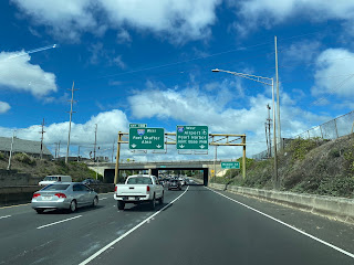
From Interstate H-1/Lunalilo Freeway westbound in Honolulu traffic staying in lane merges onto Intestate H-201/Moanalua Freeway at the Middle Street Interchange via Exit 19B. Oddly Interstate H-1 crosses over itself to transition from the Lunalilo Freeway to the Queen Liliuokalani Freeway.
Interstate H-201/Moanalua Freeway westbound Exit 4 accesses Fort Shafter via Ahua Street.
Interstate H-201/Moanalua Freeway westbound Exit 3 accesses HI 7310/Puuloa Road.
Interstate H-201/Moanalua Freeway westbound Exit 2 accesses Moanalua Valley, Salt Lake and Red Hill.
Interstate H-201/Moanalua Freeway westbound Exit 1E accesses Aloha Stadium whereas Exit 1D accesses Interstate H-3. Interstate H-201 Exit 1C accesses Interstate H-1 before the Moanalua Freeway terminates at HI 99/Kamehameha Highway.
Part 3; Roadwaywiz on Interstate H-201
During May of 2019 Dan Murphy of the Roadwaywiz YouTube Channel (and Gribblenation) featured real time drives on Interstate H-201. Below Interstate H-201 and the Moanalua Freeway can be seen eastbound.
Below Interstate H-201 and the Moanalua Freeway can be seen westbound.
The Pre-Emption Road (or rather a series of roads named Pre-Emption Road) follows a survey line called the Pre-Emption Line, drawn in the early days of the United States. The story begins with Massachusetts and New York having competing land claims to modern day Western New York State that have their roots in colonial charters granted by the British. After the Revolutionary War ended, this land became the frontier of the nation and its settlement became a priority for the new American government. During this era, there were a lot of competing land claims that needed to be settled. It was no different with the land claims between New York State and Massachusetts. On November 30, 1786, Massachusetts and New York sent representatives to Hartford, Connecticut to resolve their competing land claims. In less than three weeks, the representatives had reached a compromise. Massachusetts would receive pre-emption rights, meaning the right to sell the land after the Indian title ...
Our tagline on the Gribblenation blog is "because every road tells a story". Some roads tell different stories than others. Along our travels, we may see historic markers that tell us a little story about the roads we travel or the places we pass by. Some historic markers are more general, as to telling us who lived where or what old trail traversed between two towns. During my travels across New York State and other states or provinces, I pass by many historic markers, some with interesting or amusing references to roads. I wanted to highlight a few of the markers I've seen along my travels around the Empire State and help tell their stories. Those stories may be as specific as explaining the tales of a tree that was used to help measure a distance of eight miles from Bath to Avoca in Steuben County, as referenced on the Eight Mile Tree historical marker above. They may also help point the way along historical roads first used centuries ago, or may help tell a local l...
After leaving Barstow via Old Highway 58 my next destination was in Death Valley. To access Death Valley from rural San Bernardino County required a trek on north on Interstate 15 to California State Route 127 which becomes Nevada State Route 373 at the state line. Along I-15 I encountered the road sign oddity that is Zzyzx Road about eight miles south of Baker. Zzyzx Road is a four mile road that used to go to the Zzyzx Mineral Springs and Health Spa. The spa was founded in the 1940s and the owner made up the name "Zzyzx" to claim it was the last word in the English Language. The spa has been shut down since the 1970s and is now part of a Desert Studies Center for California State University. The southern terminus of CA 127 in Baker is located at I-15 exit 246. CA 127 is a 91 mile north/south highway which runs to the Nevada State Line in Inyo County. CA 127 is called Death Valley Road from I-15 northward. South of CA 127 ...


Comments