
Hawaii Route 61 is a 10.8 mile long State Highway mostly known as the Pali Highway. Hawaii Route 61 is one of three highways that crosses the Ko'olau Range of the Island of O'ahu. Hawaii Route 61 originates at Hawaii Route 98/Vineland Boulevard near downtown Honolulu. From Honolulu Hawaii Route 61 ascends through Nu'uanu Valley to the cliffs of Nu'uanu Pali in the Ko'olau Range. From Nu'uanu Pali the alignment of Hawaii Route 61 descends through the Nu'uanu Pali to a northern terminus in Kailua.

This page is part of the Gribblenation Hawaii Roads series. A compellation of all Hawaii-related media from both Gribblenation and RoadwayWiz can be found by clicking here.

Much of the early history of the Pali Highway can be found displayed at the Nu'uanu Pail Lookout. What is now the Pali Highway was originally a trail used by the Hawaiians to cross the Ko'olau Range to the windward side of O'ahu. The Pali Trail is most well known historically for the 1795 Battle of Nu'uanu. The Battle of Nu'uanu was spurred by Kamehameha I as part of his conquest to unite the Hawaiian Islands under his rule. The Battle of Nu'uanu saw the forces of Kamehameha I pitted against the O'ahu forces led by Maui's Chief Kalanikūpule. The Battle of Nu'uanu culminated in the forces of Kalanikūpule being forced uphill from Nu'uanu Valley and over the cliffs of Nu'uanu Pali. Kamehameha I following the conquest of O'ahu would go on to become the first king of a united Hawaii.

The difficulties of the Pali Trail are stated at the Nu'auanu Pail Lookout via a 1831 quote from Reverend Rueben Tinker:
"The pass was almost too fearful to be enjoyed. I suffered from apprehension lest I should fall from the rock steep. I took off my shoes and by setting my feet in the crevices of the rock, I worked along, assisted by a native , who saw nothing to wonder at but my awkwardness and fear on passing this grand highway."
In 1845 the Pali Trail was expanded to a six foot wide stone roadway which permitted horses to travel over Nu'aunu Pali. The expansion of the Pail Trail into a roadway saw the travel time from Honolulu to the windward side of O'ahu drop to three hours overland.

In 1897 a new alignment of the Pali Road was built directly beneath the 1845 alignment. During excavation of the 1897 Pali Road numerous skull fragments from warriors slain in the 1795 Battle of Nu'aunu were discovered beneath Nu'aunu Pali. The 1897 Pali Road opened to the public during 1898. The 1897 Pali Road featured a 20 foot wide roadway and grades of 8% percent.


During the lead up into World War II the 1897 Pali Road was modernized to facilitate automotive traffic. This culminated in the Pali Road Bridge being completed over the cliffs of Nu'aunu Pail in 1932. The Pali Road Bridge is a concrete stringer design which can be found directly below the Nu'aunu Pali Lookout along with the ruins of the abandoned 1897 Pali Road.


During World War II the territory of Hawaii saw an influx of military activity following the attack on Pearl Harbor on December 7th, 1941. Numerous Military Routes and early Hawaii Routes were signed through the Hawaiian Territory to aid military personnel in navigating the islands. Military Highways were assigned US Route style shields whereas lesser highways were assigned an early variation of what is now the Hawaii Route Spade. A 1946 Army Map of the Island of O'ahu shows the Pali Road assigned as part of Military Route 13 south of Nu'aunu Pali and Hawaii Route 160 north of it. A full version of the 1946 Army Map of O'ahu can be seen on hawaiihighways.com here.


Circa 1955 following the conclusion of World War II the United States Bureau of Public Roads renumbered the Hawaii Route System. The 1955 Hawaii Route renumbering saw most of the conventions utilized by the current Hawaii State Route System established. Primary Hawaii Routes were given two digit numbers whereas Secondary Hawaii Routes were given three digit numbers. The Hawaii Routes were assigned in sequence for what Island/County they were located on coupled with what Federal Aid Program number they were tied to. In the case of O'ahu the Island was assigned numbers in the range of 60-99. A far more detailed explanation of the 1955 Hawaii Route Renumbering can be found at hawaiihighways.com here.
In the case of the Pali Road it was assigned as Hawaii Route 61 ("HI 61") given it's improvements were tied to Federal Aid Secondary Program 610. Federal Aid Secondary Program 610 included improvements to the existing Pali Road via the planned Nu'aunu Pali Tunnels. The southern Nu'aunu Pali Tunnels were completed during 1959 the same year Hawaii obtained Statehood. The northern Nu'aunu Tunnels were completed during 1961 with the final portions of the new Pali Highway being completed in 1962 according hawaiiroads.com. Following the completion of the Nu'aunu Pail Tunnels the older 1897 Pali Road was abandoned. Since the 1960s HI 61 and the Pali Highway have seen few changes. A photo showing existing HI 61 during 1960 during the transition to the modern Pali Highway can be seen on hawaiihhighways.com here.
Part 2; a drive on Hawaii Route 61
As noted in Part 1 HI 61 begins from HI 98 at Vineland Boulevard in Honolulu. Our tour of HI 61 eastbound begins from Interstate H-1. Interstate H-1 westbound intersects HI 61 0.2 miles from it's western terminus at HI 98 via Exit 21B.


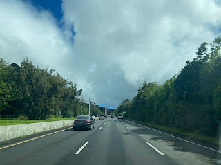
HI 61 east of Interstate H-1 transitions onto the four lane expressway Pali Highway. Approaching Kuakini Street travelers on HI 61 are advised there is access to the National Memorial Cemetery of the Pacific at the Punchbowl Crater.


Punchbowl Crater is an extinct volcanic tuff cone located above downtown Honolulu which is thought to have formed 75,000-100,000 years ago. The National Memorial Cemetery of the Pacific was approved by Congress during February of 1948 and was dedicated on September 2nd, 1949. The National Memorial Cemetery of the Pacific mostly houses the remains of Veterans from World War II, the Korean War and Vietnam War. In total over 61,000 Veterans are interred at the National Memorial Cemetery of the Pacific.

The view of downtown Honolulu from Punchbowl Crater along Puowaina Drive.

Returning to HI 61 eastbound the highway ascends into Nu'uanu Valley and intersects it's older alignment at Nu'uanu Pali Drive.


HI 61 eastbound ascends through Nu'uanu Valley to the Nu'uanu Pali Lookout Exit.


Nu'uanu Pali Lookout is located at an elevation of 1,168 feet above sea level. From Nu'uanu Pail Lookout one can see the sheer cliffs for the Ko'olau Mountains contrasted with the waters of Kāneʻohe Bay. Kāneʻohe Bay and the cliffs of the Ko'olau Mountains are the remains of the western half of the Ko'olau Volcano. Much of the Ko'olau Volcano's eastern half has long slid northeast into the Pacific Ocean over a 100 mile wide debris field. Kāneʻohe Bay essentially is the remaining caldera of the Ko'olau Volcano.


As noted in Part 1 the remains of the 1897 Pali Road can be found from the Nu'uanu Pali Lookout.


From the Nu'uanu Pali Lookout the northern Nu'uanu Pali Tunnels can be observed.

From the Nu'uanu Pali Lookout HI 61 eastbound passes through the southern Nu'uanu Pali Tunnels.


From the northern Nu'uanu Pali Tunnels HI 61 eastbound descends to a junction with HI 83/Kamehameha Highway.


HI 61 eastbound follows Kailua Road into Kailua. HI 61 terminates on Kailua Road as it crosses Kawainui Bridge (dated via year stamp to 1940). According to hawaiiroads.com HI 61 likely originally followed Kailua Road and Kuulei Road to former Honolulu County Route 638 at Kalaheo Road.


Kailua Beach can be found along Kalaheo Avenue at what was likely the original eastern terminus of HI 61. From across Kailua Bay one can see Marine Corps Station Hawaii along with Popoia Island.


Part 3; RoadwayWiz on Hawaii Route 61
During May of 2019 Dan Murphy (also of Gribblenation) featured the entirety of HI 61 on the RoadwayWiz Youtube Channel. Below HI 61 eastbound can be seen following the Pail Highway from HI 92/Vineland Boulevard to Interstate H-1.
Below HI 61 eastbound can be seen following the Kalaniana'ole Highway to HI 72.
Below HI 61 eastbound can be seen following Kailua Road to it's terminus in Kailua.
Comments