
Diamond Head State Monument

Diamond Head Crater is a volcanic tuff cone on the Hawaiian Island of O'hau located in the City of Honolulu.  The Diamond Head Crater is surrounded by several neighborhoods of Honolulu and offers a vista of the City from the top of the Summit Trail.  Diamond Head Crater in the Hawaiian language is known as Lēʻahi.

This page is part of the Gribblenation O'ahu Highways page.  All Gribblenation and Roadwaywiz media related to the highway system of O'ahu can be found at the link below:

https://www.gribblenation.org/p/gribblenation-oahu-highways-page.html


Part 1; the history of Diamond Head State Monument 

The formation of O'ahu began between 2.5-4 million years ago with volcanic eruptions from two shield volcanos emerging into a land mass from the Pacific Ocean.  Over time the erosion of the two shield volcanos formed the basis of the modern Ko'olau and Wai'anae Mountain Ranges.  Approximately 1.3 million years ago volcanic activity began in the Pacific Ocean at the southeastern end of the Ko'olau Range forming numerous cones.  Lēʻahi is thought to have formed approximately 300,000 years ago from a single and brief eruption.  Since erupting Lēʻahi began to erode into the state it is seen today.

In 1825 Lēʻahi was named "Diamond Hill" by British Sailors.  The British mistook the volcanic calcite crystals on Lēʻahi for diamonds.  Despite the lack of actual diamonds present on Lēʻahi the English name stuck and eventually became "Diamond Head" due to it being part of a headland.  Diamond Head/Lēʻahi can be seen on 1856 J.H. Colton Map of the Hawaiian Islands on O'ahu. 


Diamond Head can be seen in much greater detail on the 1881 Hawaiian Government Survey Map of O'ahu


In 1904 Diamond Head was purchased by the Federal Government of the United States and designated for military use.  Fortification of Diamond Head began in 1908 with construction of gun emplacements and the Kapahulu Tunnel on the northern rim.  Originally known as "Diamond Head Reservation" the military encampment was renamed to "Fort Ruger" during 1909.  The Fire Control Station which is now the top of the Summit Trail to the top of Diamond Head was constructed circa 1908-1910.  Coastal Batteries were added to Diamond between 1910-1916 with one additional (Battery 407) being constructed during 1943.  The construction of Battery 407 included excavation of the Kahala Tunnel through the eastern rim of Diamond Head which now is part of the State Monument entrance road.  Diamond Head and Fort Ruger as they were immediately after World War II can be seen on the 1946 Army Map of O'ahu.


The importance of Fort Ruger diminished following World War II with much of the U.S. Army infrastructure inside Diamond Head becoming obsolete.  Diamond Head Crater was declared a Hawaii State Monument in 1962 and became a National Natural Landmark in 1968.  In modern times a few military facilities such remain active at Diamond Head Crater such as; the northern Kapahulu Tunnel, Battery 407, the Hawaii State Civil Defense Headquarters and a National Guard emergency operations center.


Part 2; hiking the Summit Trail to the top of Diamond Head Crater

From flying overhead Honolulu Diamond Head Crater is an obvious geographic feature.  From the view below Diamond Head Crater can be seen towering east of Waikiki. 


Diamond Head State Monument is accessible via Diamond Head Road along the eastern rim of the Crater.  Traffic entering Diamond Head Crater must utilize the one lane Kahala Tunnel.  


Traffic emerges from the Kahala Tunnel into the center of Diamond Crater where the trailhead for the Summit Trail can be found at the Diamond Head State Monument Visitor Center.  


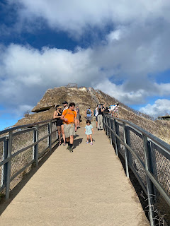
The Summit Trail is approximately 0.8 miles long but gains 560 feet in elevation.  The starting portion of the Summit Trail is paved but comes a rock surface approaching the Diamond Head Crater rim.  


The Summit Trail ascends through a series of rock switchbacks to an observation deck overlooking the center of Diamond Head Crater. 


The Summit Trail ascends 74 stairs to a 225 foot long tunnel.  


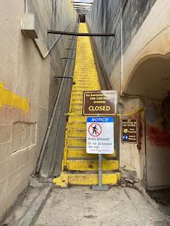
The Summit Trail emerges onto a second set of stairs which has 99 steps.  The second set of stairs is advertised as a spur which can be used to access a second tunnel to the interior of the Fire Control Station.  Unfortunately the spur trail to the Fire Control Station was closed when I was hiking the Summit Trail. 


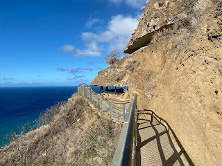
The Summit Trail approaches a metal staircase with a spur which overlooks Koko Crater east of Diamond Head Crater. 


The metal staircase is 82 steps high approaching the Fire Control Station observation point.  From the top of the 82 step metal staircase the 1917 Diamond Head Lighthouse can be below.  


A final 54 step metal staircase ascends to the Fire Control Station observation point located at 761 feet above sea level.  Looking westward a full view of Waikiki and downtown Honolulu can be observed. 


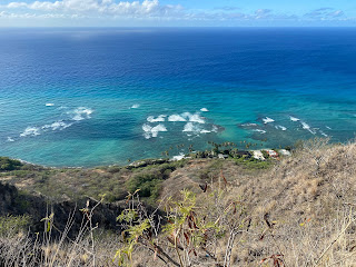
The entirety of Diamond Head Crater can be seen from the Fire Control Station observation point facing east.  Much of the Ko'olau Range and Koko Crater can also be observed facing eastward. 


Comments

Popular posts from this blog

North Carolina Continues to Move Forward with Rail

2023 and the first half of 2024 have seen continued growth in North Carolina's passenger rail system.  From increased daily trains from Raleigh to Charlotte, federal funds for studying additional corridors, and receiving a historic grant to begin the construction of high-speed rail between Raleigh and Richmond, the last 18 months have been a flurry of activity at NCDOT's Rail Division.  And that's just the tip of the iceberg. As ridership and routes increase - the engine of North Carolina passenger rail trains will become a more common sight. (Adam Prince) Increased Passenger Train Service: On July 10, 2023, a fourth Piedmont round-trip rail service between Raleigh and Charlotte commenced.  The four Piedmont trains plus the daily Carolinian (to Washington, DC, and New York) bring the total of trains serving the two cities daily to five. The current daily Piedmont and Carolinian schedule between Charlotte and Raleigh (NCDOT) The result was over 641,000 passengers utilized pa

US Route 101 in Benbow, Garberville and Redway

The communities of Benbow, Garberville and Redway can all be found along US Route 101 within southern Humboldt County.  The former surface alignment of US Route 101 in Garberville and Redway once crossed the Garberville Bluffs along what is now Redwood Drive via a corridor constructed as part of the Redwood Highway during the 1910s.  US Route 101 through Benbow, Garberville and Redway was modernized by 1935.  US Route 101 would eventually be upgraded to freeway standards in Benbow, Garberville and Redway by extension of the Redwood Freeway during 1966-68.  As the cover photo the original grade of US Route 101 and the Redwood Highway can be seen at the Garberville Bluffs during 1934.  US Route 101 can be seen in the communities of Benbow, Garberville and Redway on the 1935 Division of Highways Map of Humboldt County .   The history of US Route 101 in Benbow, Garberville and Redway Benbow, Garberville and Redway lie on the banks of the South Fork Eel River of southern Humboldt County.  D

The Midway Palm and Pine of US Route 99

Along modern day California State Route 99 south of Avenue 11 just outside the City limits of Madera one can find the Midway Palm and Pine in the center median of the freeway.  The Midway Palm and Pine denotes the halfway point between the Mexican Border and Oregon State Line on what was US Route 99.  The Midway Palm is intended to represent Southern California whereas the Midway Pine is intended to represent Northern California.  Pictured above the Midway Palm and Pine can be seen from the northbound lanes of the California State Route 99 Freeway.   This blog is part of the larger Gribblenation US Route 99 Page.  For more information pertaining to the other various segments of US Route 99 and it's three-digit child routes check out the link the below. Gribblenation US Route 99 Page The history of the Midway Palm and Pine The true timeframe for when the Midway Palm and Pine (originally a Deadora Cedar Tree) were planted is unknown.  In fact, the origin of the Midway Palm and Pine w