
Hawaii Route 98 Vineyard Boulevard

Hawaii Route 98 is a 1.8-mile State Highway located on the Island of O'ahu in the City of Honolulu.  The entirety of Hawaii Route 98 is aligned on Vineyard Boulevard from Interstate H-1/Luanlilo Freeway Exit 20B to Exit 22.  

This page is part of the Gribblenation O'ahu Highways page.  All Gribblenation and Roadwaywiz media related to the highway system of O'ahu can be found at the link below:

https://www.gribblenation.org/p/gribblenation-oahu-highways-page.html


Part 1; the history of Hawaii Route 98

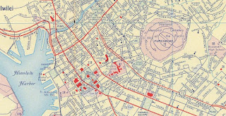
Prior to the Statehood the first signed highways within Hawaii Territory came into existence during World War II.   During World War II the territory of Hawaii saw an influx of military activity following the attack on Pearl Harbor on December 7th, 1941.  Numerous Military Routes and early Hawaii Routes were signed through the Hawaiian Territory to aid military personnel in navigating the islands.  Military Highways were assigned US Route style shields whereas lesser highways were assigned an early variation of what is now the Hawaii Route Spade.  What is now Vineyard Boulevard in Boulevard was originally known as Vineland Street and did not have a World War II era Hawaii Route assigned to it.  Vineyard Street was named after the numerous vineyards which used to line it.  A full version of the 1946 Army Map of O'ahu can be seen on hawaiihighways.com here.  


The beginnings of what is now known as the Lunalilo Freeway was completed in downtown Honolulu as the Mauka Arterial during November 1953.  The Mauka Arterial was approximately 1 mile length between Kapiolani Boulevard westward to Kapiolani Hospital at Punahou Street.

Circa 1955 following the conclusion of World War II the United States Bureau of Public Roads renumbered the Hawaii Route System.  The 1955 Hawaii Route Renumbering saw most of the conventions utilized by the current Hawaii State Route System established.  Primary Hawaii Routes were given two digit numbers whereas Secondary Hawaii Routes were given three digit numbers.  The Hawaii Routes were assigned in sequence for what Island/County they were located on coupled with what Federal Aid Program number they were tied to.  In the case of O'ahu the Island was assigned numbers in the range of 60-99.  In the case of the Mauka Arterial corridor it was initially assigned as part of Hawaii Route 72.  A far more detailed explanation of the 1955 Hawaii Route Renumbering can be found at hawaiihighways.com here

The planned corridor of the Mauka Arterial can be observed on the 1956 Shell Highway Map of Honolulu.  The Mauka Arterial is shown having a planned connection to Vineyard Street.  


The 1959 Gousha Map of Hawaii shows the Vineland Street extension acting as part of the interim alignment of Hawaii Route 72 while the Lunalilo Freeway was under construction.  Hawaii Route 72 is shown diverting from the end of the completed Lunalilo Freeway segment onto Lunalilo Boulevard west to the Vineyard Street extension.  Hawaii Route 72 is shown aligned on Vineyard Street west to Nuuanu Boulevard and southward to Beretania Street.  Notably the Vineyard Street extension is not shown to be yet continuous with the existing segment west of Foster Botanical Garden.  

On August 21st, 1959 Hawaii became the 50th State which saw its profile rise significantly.  The Hawaii Department of Transportation's History of Interstate H-3 guide details much of the early history of the Interstate System in Hawaii.  The Interstate System in Hawaii was authorized as part of the 1960 Statehood Act.  The 1960 Statehood Act authorized Interstates H-1, H-2 and H-3 on the Island of O'ahu.  Hawaii Route 72 was reassigned as part of Interstate H-1 as part of the 1960 Statehood Act. 


Hawaiihighways.com details the construction history of Interstate H-1 on their O'ahu page.  The first segment of the Lunalilo Freeway to be constructed as Interstate H-1 between Exit 25B east to 26A was completed by 1965.  This segment can be seen under construction in the 1965 Hawaii Department of Transportation photo below.  


Interstate H-1 on the Queen Liliuokalani Freeway from Exit 5 (Hawaii Route 76/Hawaii Route 750) to its western terminus opened during 1967.  The remainder of the Lunalilo Freeway segment of Interstate H-1 in Honolulu was completed by July 1969.  The entirety of Vineyard Boulevard can be seen assigned as Hawaii Route 98 on the October 1968 Interstate H-4 proposal document titled: Proposed Route H-4.


Hawaii Route 98 can be seen as a loop of Interstate H-1/Lunalilo Freeway Exit 20B-22 on the 1969 USGS Map of Honolulu.  


Part 2; a drive on Hawaii Route 98

Eastbound Hawaii Route 98 begins from Interstate H-1/Lunalilo Freeway Exit 20B. 


Hawaii Route 98 follows Vineyard Boulevard 1.8 miles eastward back to Interstate H-1/Lunalilo Freeway with the only major coming Hawaii Route 61/Pali Highway.  Eastbound Hawaii Route 98 is well signed and even has an END placard upon terminating at Interstate H-1/Lunalilo Freeway.


Westbound Hawaii Route 98 begins from Interstate H-1/Lunalilo Freeway Exit 22.


An oddly specific 1.76 Mile Marker can be seen as westbound Hawaii Route 98 begins on Vineyard Boulevard. 


Traffic on westbound Hawaii Route 98/Vineyard Boulevard is notified Punchbowl Street can be used to returned to westbound Interstate H-1/Lunalilo Freeway.  


Hawaii Route 98/Vineyard Avenue intersects Hawaii Route 61/Pali Highway and loops back to Interstate H-1/Lunalilo Freeway. 


Miscellaneous photos of westbound Hawaii Route 98/Vineyard Boulevard.  Notably there is signals on Hawaii Route 98/Vineyard Boulevard westbound showing if the Tunnels on Hawaii Route 63/Likelike Highway and Interstate H-3 are closed. 


During May of 2019 Dan Murphy of the Roadwaywiz YouTube Channel and Gribblenation featured real-time drives on Hawaii Route 98.  Below Hawaii Route 98 westbound can be viewed. 


Below Hawaii Route 98 eastbound can be viewed.


Comments

Popular posts from this blog

Former US Route 50 and the Pioneer Route Lincoln Highway on Johnson's Pass Road

Johnson's Pass Road is one of the oldest highway corridors in California.  Johnson's Pass was part of the Lake Tahoe Wagon Road as it was completed during 1856 over the Sierra Nevada.  The pass would later be incorporated into the Pioneer Branch of the Lincoln Highway in 1913 and US Route 50 in 1926.  Johnson's Pass Road would be bypassed by a new alignment of US Route 50 over Echo Summit in 1938.  A replacement of the Meyers Grade east of Johnson's Pass would be opened to traffic in 1947.   Johnson's Pass Road remains accessible to traffic and is still signed by the Lincoln Highway Association.  Pictured as the blog cover is the view from the top of Johnson's Pass Road overlooking modern US Route 50 and Lake Tahoe.   Part 1; the history of Johnson's Pass Much of the history of what become the Lake Tahoe Wagon Road is discussed in the  September 1950 California Highways & Public Works  during its Centennial Edition.  The or...

Former US Route 50 and the South Lincoln Highway from Folsom east to Placerville

The corridor of Folsom of Sacramento County east to Placerville of El Dorado County has been a long established corridor of overland travel dating back to the California Gold Rush.  The Folsom-Placerville corridor was once part of the path of the Lake Tahoe Wagon Road which became the first California State Highway and later the South Lincoln Highway.  In time the South Lincoln Highway's surface alignment was inherited by US Route 50.  The Folsom-Placerville corridor also includes the communities of; Clarksville, Shingle Springs and El Dorado. Part 1; the history of the Lake Tahoe Wagon Road, South Lincoln Highway and US Route 50 through Folsom-Placerville Folsom is located on the American River/Lake Natoma of eastern Sacramento County.  That lands now occupied by the City of Folsom were part of Rancho Rio de los Americanos prior to the finding of gold at Sutter's Mill during 1848.  During the California Gold Rush the lands of Rancho Rio de los Americanos were p...

Old NC 10 - The Central Highway: Old Fort to Black Mountain through the Royal Gorge

A unique way of tracing the remnants of the Central Highway is through the mountainous terrain of Eastern Buncombe and Western McDowell Counties.  From the east on US 70, you reach the base of Blue Ridge Mountains at the town of Old Fort.  Old Fort is a tiny rail town that the old Central Highway and now US 70 goes through.  The Central Highway can be followed via a right onto Mill Creek Road from US 70.  Follow the highway as it takes you closer to the mountains.  When Mill Creek Road bears right to head towards Andrews Geyser stay straight until the road ends at a gate.  The nearby Piney Grove Church can be used for parking.  At this point, the old Central Highway began a 3.5 mile climb of the mountain to Swannanoa Gap.  NC 10 and later US 70 travelers followed this road for over 30 years until a new and modern four lane US 70 was built to the south.  This same four lane road would eventually become Interstate 40.    The Centra...