
Colemanville Covered Bridge - Lancaster County, Pennsylvania


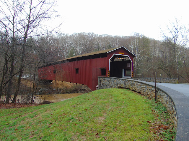
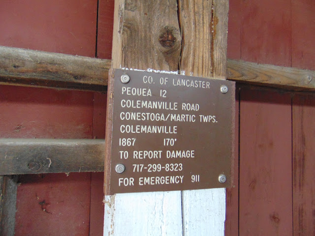
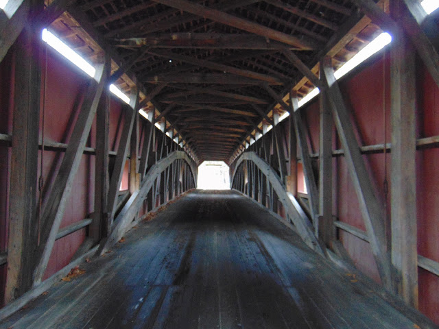
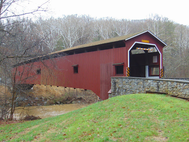
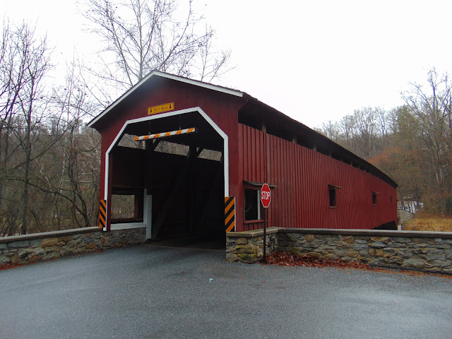
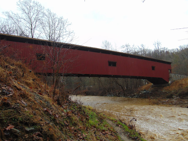
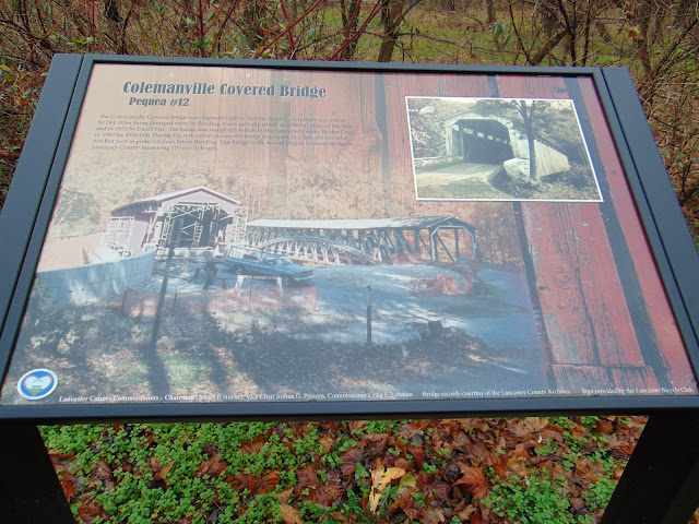
The Colemanville Covered Bridge is the second longest covered bridges in Lancaster County and also one of the longer covered bridges in the entire Commonwealth of Pennsylvania, spanning 156 across the Pequea Creek on the border between Conestoga and Martic Townships. Given the alternate name of Pequea # 12 in Lancaster County's list of covered bridges, the Colemanville Covered Bridge was first built in 1856 by James C. Carpenter at the cost of $2,224. It is Lancaster County's second longest single span covered bridge that is still in use. The bridge has a single span with double Burr arch trusses design with the addition of steel hanger rods. The bridge deck is made from oak planks. Like most bridges in Lancaster County, the Colemanville Covered Bridge is painted red, which is the traditional color used for covered bridges in the county.

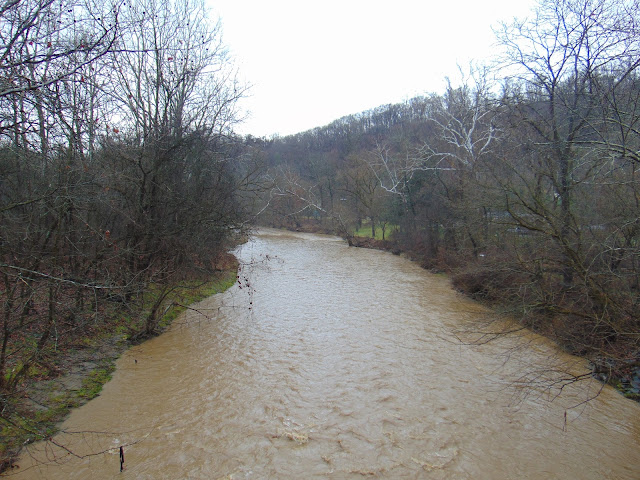
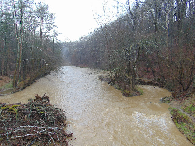
The bridge was partially rebuilt in 1938 and 1973 after flooding events caused damage to the covered bridge. Then in 1992, the Colemanville Covered Bridge was completely rebuilt at the tune of $350,000. During the rebuilding, the bridge was raised by six feet and moved slightly to the west in order to prevent future flooding from damaging the bridge. As a result, the bridge can be enjoyed for generations to come. I managed to visit the bridge on a day following plenty of rain and am happy to report that the bridge remained high and dry.


How to Get There:


Sources and Links:
Bridgehunter.com - Colemanville Covered Bridge 38-36-55
Galenfrysinger.com - Colemanville Covered Bridge
Visit Lancaster PA - Covered Bridges in Lancaster PA
Interesting Pennsylvania and Beyond - Colemanville Covered Bridge, Lancaster County


Update Log:
January 14, 2022 - Crossposted to Quintessential Pennsylvania - https://quintessentialpa.blogspot.com/2022/01/colemanville-covered-bridge.html

Comments

Popular posts from this blog

When did people begin to refer to the "Ridge Route" as "The Grapevine?" (former US Route 99 and Interstate 5)

The segment of US Route 99 from Los Angeles north to Bakersfield was traditionally known in State Highway documents as the "Ridge Route."  Even as the Ridge Route was transitioning from curvy mountain grade to the facility now occupied by Interstate 5nthe name largely persisted in California Highways & Public Works documents.  During modern times the name "Ridge Route" has be usurped in popular lexicon in favor to the nickname known as "The Grapevine."  This blog will attempt to decipher the origins of "The Grapevine" and how it came into popular use today.  Featured as the blog cover photo is a view of Interstate 5 in Grapevine Canyon and former US Route 99 at Deadman's Curve of the Ridge Route. This blog is part of the larger Gribblenation US Route 99 Page.  For more information pertaining to the other various segments of US Route 99 and it's three-digit child routes check out the link the below. Gribblenation US Route 99 Page Note:

US Route 101 in Benbow, Garberville and Redway

The communities of Benbow, Garberville and Redway can all be found along US Route 101 within southern Humboldt County.  The former surface alignment of US Route 101 in Garberville and Redway once crossed the Garberville Bluffs along what is now Redwood Drive via a corridor constructed as part of the Redwood Highway during the 1910s.  US Route 101 through Benbow, Garberville and Redway was modernized by 1935.  US Route 101 would eventually be upgraded to freeway standards in Benbow, Garberville and Redway by extension of the Redwood Freeway during 1966-68.  As the cover photo the original grade of US Route 101 and the Redwood Highway can be seen at the Garberville Bluffs during 1934.  US Route 101 can be seen in the communities of Benbow, Garberville and Redway on the 1935 Division of Highways Map of Humboldt County .   The history of US Route 101 in Benbow, Garberville and Redway Benbow, Garberville and Redway lie on the banks of the South Fork Eel River of southern Humboldt County.  D

Old Stage Road in Tulare County and Kern County

Old Stage Road is an approximately 30-mile rural highway comprised of Tulare County Mountain Road 1, Kern County Mountain Road 447 and Tulare County Mountain Road 109.  Old Stage originates at Jack Ranch Road near Posey and ends at the outskirts of Porterville at Deer Creek.  Old Stage Road notably is comprised of two 19th Century stage routes.  From White Mountain Road northwest to Fountain Springs, Old Stage Road overlays Thomas Baker's 1860s era stage road to Linn Valley (now Glennville) and the Kern River Gold Rush Claims.  From Fountain Springs to Deer Creek, Old Stage Road is comprised of the 1853 Stockton-Los Angeles Road. Featured as the blog cover is the northward descent on Old Stage Road along Arrastre Creek to the town site of White River.  What became White River was settled along a spur of the Stockton-Los Angeles Road as "Dog Town" when gold was discovered nearby.  By 1856 the community had been renamed Tailholt.  A stage road from Tailholt to Linn Valley w