
Wyoming Road Trip - Days 7 & 8: Returning Home

Wyoming and South Dakota were amazing - but now it's time to head back to North Carolina with two long days of driving ahead.

Day 7 Route: I-180, I-80, I-74, local roads to Champagne, IL.

Photo Set on Flickr: Wyoming Road Trip Day 7

Day 8 Route: I-74, I-465, I-65, I-64, I-75, I-40, US 25/70, I-240, I-40, NC 16, I-485, Home.

Photo Set on Flickr: Wyoming Road Trip Day 8

Friday, Day 7, was a true go as far as you can in as little time as you can.  The plan was to take two days to get back to Charlotte plus time for Joe to drive the three and a half hours to Wilmington on Saturday evening.  

We left at around 5:30 am and finally traveled the infamous Interstate 180 to I-80 to start going west.  Since it was dark, no photos, which I know to some in the roadgeeking hobby is probably a good thing.  

We did, however, catch a pretty nice sunrise in Western Nebraska.


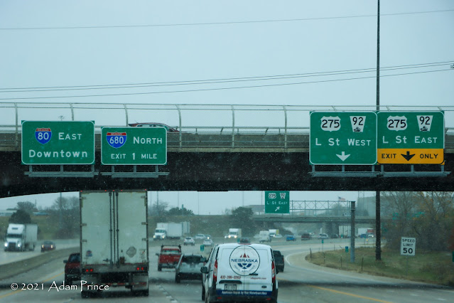
Snow flurries in Omaha - Somewhere in the Middle of America

Interstate 80, as we discussed earlier, is a rather boring non-descript highway.  But around Omaha, things got a little more interesting and some light snow flurries saved an otherwise photo-less part of the trip.

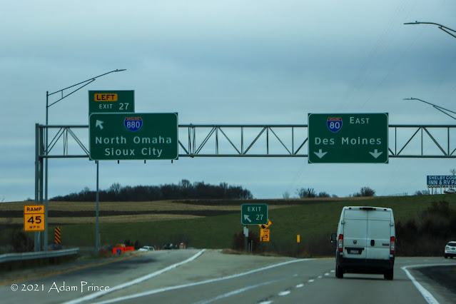
Interstate 880 is one of the newest designations in the Interstate System.


This time I got to see Iowa in daylight.  With the cold overcast day, there wasn't too much to take photos of, and by the time we go to Illinois, it was dark.   

Saturday, Day 8, would be a little more interesting.

We weren't planning to go through Downtown Indianapolis, and that's a good thing.  Construction on the I-65/70 "North Split" has Indiana recommending thru traffic to use the 465 loop.


We started to find a return to some fall color in Kentucky and Tennessee.


Our original plan was simple, take 40 through the mountains home.  Unfortunately, a vehicle fire at the TN/NC line - and construction for a new bridge and wildlife underpass at the Harmons Den (Exit 7) interchange on I-40 were causing significant delays.  So backup plan, US 25/70 to Asheville and I-40.  It had been a good 12-15 years since I had taken this route, so it was a great final pleasant surprise.

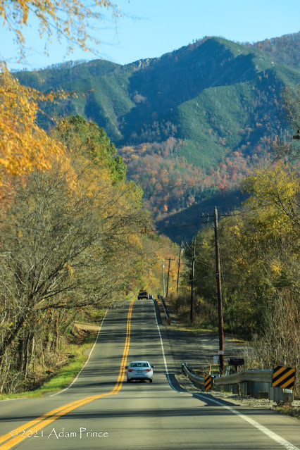
US 25/70 in Eastern Tennessee


With that, it was an easy ride home and the end to a wonderful trip.

2021 Wyoming Road Trip Site Navigation:

Comments

Popular posts from this blog

The 1915-era Teilman Bridge (the only known Concrete Pony Truss Bridge in California)

The Teilman Bridge is a semi-abandoned structure over Fresno Slough west of Burrell siding near the intersection of Elkhorn Avenue and Elkhorn Grade.  This structure is the only known Concrete Pony Truss Bridge constructed in California and was designed by Ingvart Teilman.  Teilman's Bridge would open in late 1915 when the Elkhorn Grade was the primary road between Fresno and Coalinga.  The structure would be replaced in 1991 but was left standing as it carries pipelines over Fresno Slough.  Part 1; the history of the Teilman Bridge In the early Twentieth Century the most direct highway between Fresno and Coalinga followed the Elkhorn Grade.  The Elkhorn Grade began at Fresno Slough a short distance west of Burrell siding.  From Fresno Slough the Elkhorn Grade followed a generally southwestern course through San Joaquin Valley into the Kettleman Hills towards Coalinga.   The Elkhorn Grade can be seen on the  1914 C.F. Weber map of Fresno Coun...

The Dummy Lights of New York

  A relic of the early days of motoring, dummy lights were traffic lights  that  were  placed  in the middle of a street intersection. In those early days, traffic shuffled through busy intersections with the help of a police officer who stood on top of a pedestal. As technology improved and electric traffic signals became commonplace, they were also  originally  positioned on a platform at the center of the intersection. Those traffic signals became known as  " dummy lights "  and were common until  traffic lights were moved  onto wires and poles that crossed above the intersection.  In New York State, only a handful of these dummy lights exist. The dummy lights  are found  in the Hudson Valley towns of Beacon and Croton-on-Hudson, plus there is an ongoing tug of war in Canajoharie in the Mohawk Valley, where their dummy light has been knocked down and replaced a few times. The dummy light in Canajoharie is currently...

Prunedale Road (Monterey County)

Prunedale Road is a short 2.6-mile-long frontage corridor of US Route 101 in the namesake Monterey County community of Prunedale.  Prior to 1932 US Route 101 bypassed Prunedale in favor of the San Juan Grade to the east.  Prunedale Road along with nearby Moro Road served as an alternative connecting highway between Salinas and San Juan Bautista.  Following the realignment of US Route 101 onto the Prunedale Cutoff the former through route along Prunedale Road would be rendered as a western frontage.   Part 1; the history of Prunedale Road Prunedale Road is located in and is named after the Monterey County community of Prunedale.  Said community was founded near the junction of San Migeul Canyon, Langley Canyon and Echo Valley.  Watsonville settler Charles Langley (namesake of Langley Canyon) was one of the prominent early community settlers.  The Prunedale Post Office would open for the first time in 1894 but would close by 1908.  Early agricu...