After completing Nevada State Route 431 over Mount Rose I continued onto NV 341 on Geiger Grade Road. My next destination was Virginia City in Storey County.

NV 341 is a 22 mile State Highway from US 395A/NV 431 in Washoe County southward over the Virginia Range through Storey County to US 50 in Lyon County. From US 395A/NV 431 the route of NV 341 begins a rapid ascent on Geiger Grade Road.

The Geiger Grade opened in 1860 as a toll road from Washoe Valley to the Comstock Lode Mines of Virginia City. The Geiger Grade while narrow is a relatively shallow grade compared to the route north of Mound House to Virginia City (modern NV 342). The Geiger Grade was first signed as NV 17 in 1929.
1929 State Highway Map
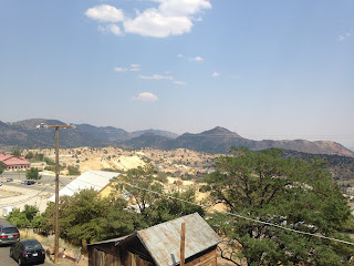
From Geiger Lookout Wayside Park there is a large overlook of Truckee Meadows and the ascending Geiger Grade/NV 341.


South from Geiger Lookout Wayside Park NV 341/Geiger Grade enters Storey County. At Lousetown Road NV 341 encounters a former way station community site which was Lousetown.


Directly south of Lousetown NV 341 emerges onto C Street in Virginia City.

Virginia City was founded in 1859 during the boom following the discovery of the Comstock Lode. Mineral wealth in the Virginia City area has been long known with gold deposits in the Virginia Range had been discovered as early as 1850 near modern day Dayton. The Comstock Lode is a large deposit of silver ore that was discovered west of Virginia City on the slopes of Mount Davidson.
The Comstock Lode is name after Henry Comstock but the earliest claims on Mount Davidson are largely attributed to discoveries by Ethan Allen and Hosea Ballou Grosh in 1857. Hosea Ballou Grosh died before any of the ore found at the claims at Mount Davidson were assessed. Ethan Allen Grosh died trying to cross the Sierras to California due to frostbite in attempt to have his ore assessed. Henry Comstock took over the Grosh Brothers cabin and claims after learning of the latter's death.
The Ophir Claim on Henry Comstock's land was later discovered and began a mining boom in the Virginia Range in vicinity of Mount Davidson which led to the Comstock Lode Gold Rush of 1859. Virginia City was quickly created and soon became the County Seat of the newly created Storey County in 1861 as Nevada Territory was split from Utah Territory. Virginia City quickly grew around the new mining claims of the Comstock Lode and reached a population of about 15,000 residents by 1863. The population boom and money generated by the Comstock Lode played a primary role in Nevada becoming a state in 1864.
Virginia City reached it's peak population of about 25,000 following the Big Bonanza of sometime between 1873 to 1875. In 1875 the Great Fire of Virginia City destroyed most of the community but it was largely rebuilt due to the mineral wealth of the Comstock Lode. By 1879 the Comstock Lode began to finally play out the City declined to about 11,000 residents.
By 1930 the population of Virginia City declined below 1,000 residents and has remained below that level ever since. The present population of Virginia today hovers just over 800. Storey County has begun to regrow slightly in areas outside of Virginia City with the present population exceeding 4,000 largely due to urban sprawl from Reno-Sparks.


Virginia City being a historic mining community has a large swath of historic buildings and other interesting structures. I parked my car at the Comstock Lode Memorial above and walked C Street/NV 341 into downtown. As I was walking into downtown Virginia City I took note of these older style gas pumps.

At Six Mile Canyon Road NV 341 encounters what was NV 79. NV 79 was 7.9 mile Legislatively Defined State Highway to Dayton and US 50 that was deleted during the 1976 State Highway renumbering.

NV 79 first appears on the 1942 Nevada State Highway Map.
1942 Nevada State Highway Map
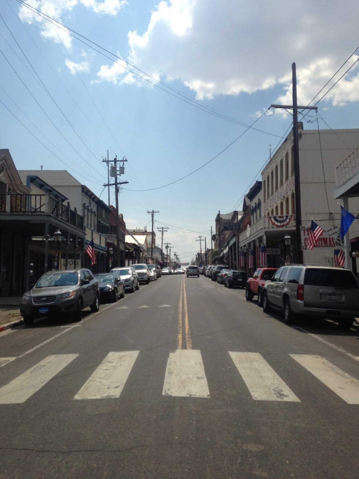
NV 341 appearance as a modern two-lane highway feels out of place in downtown Virginia City which is lined with historic buildings on C Street.


The street grid of Virginia City consists of a series of steps which provide a panoramic view of Six Mile Canyon the desert to the east from NV 341/C Street.


Another southward view on NV 341/3rd Street.

Some of the older structures in Virginia like the Washoe Club and an old fire station pre-date the 1875 Great Fire.


South of Virginia City on the outskirts of Gold Hll NV 341 has a junction with NV 342. NV 341 bypasses the communities of Gold Hill and Silver City by taking the relatively shallow Occidental Grade to the east crossing the Virginia and Truckee Railroad in the process.

NV 341 meets the southern junction of NV 342 in Silver City and continues south out of the Virginia Range into Lyon County where it terminates at US 50.

Back in 2014 I took NV 342 south from Virginia City instead of NV 341 to see Gold Hill and Silver City.


NV 341 is a 22 mile State Highway from US 395A/NV 431 in Washoe County southward over the Virginia Range through Storey County to US 50 in Lyon County. From US 395A/NV 431 the route of NV 341 begins a rapid ascent on Geiger Grade Road.

The Geiger Grade opened in 1860 as a toll road from Washoe Valley to the Comstock Lode Mines of Virginia City. The Geiger Grade while narrow is a relatively shallow grade compared to the route north of Mound House to Virginia City (modern NV 342). The Geiger Grade was first signed as NV 17 in 1929.
1929 State Highway Map
From Geiger Lookout Wayside Park there is a large overlook of Truckee Meadows and the ascending Geiger Grade/NV 341.


South from Geiger Lookout Wayside Park NV 341/Geiger Grade enters Storey County. At Lousetown Road NV 341 encounters a former way station community site which was Lousetown.


Directly south of Lousetown NV 341 emerges onto C Street in Virginia City.

Virginia City was founded in 1859 during the boom following the discovery of the Comstock Lode. Mineral wealth in the Virginia City area has been long known with gold deposits in the Virginia Range had been discovered as early as 1850 near modern day Dayton. The Comstock Lode is a large deposit of silver ore that was discovered west of Virginia City on the slopes of Mount Davidson.
The Comstock Lode is name after Henry Comstock but the earliest claims on Mount Davidson are largely attributed to discoveries by Ethan Allen and Hosea Ballou Grosh in 1857. Hosea Ballou Grosh died before any of the ore found at the claims at Mount Davidson were assessed. Ethan Allen Grosh died trying to cross the Sierras to California due to frostbite in attempt to have his ore assessed. Henry Comstock took over the Grosh Brothers cabin and claims after learning of the latter's death.
The Ophir Claim on Henry Comstock's land was later discovered and began a mining boom in the Virginia Range in vicinity of Mount Davidson which led to the Comstock Lode Gold Rush of 1859. Virginia City was quickly created and soon became the County Seat of the newly created Storey County in 1861 as Nevada Territory was split from Utah Territory. Virginia City quickly grew around the new mining claims of the Comstock Lode and reached a population of about 15,000 residents by 1863. The population boom and money generated by the Comstock Lode played a primary role in Nevada becoming a state in 1864.
Virginia City reached it's peak population of about 25,000 following the Big Bonanza of sometime between 1873 to 1875. In 1875 the Great Fire of Virginia City destroyed most of the community but it was largely rebuilt due to the mineral wealth of the Comstock Lode. By 1879 the Comstock Lode began to finally play out the City declined to about 11,000 residents.
By 1930 the population of Virginia City declined below 1,000 residents and has remained below that level ever since. The present population of Virginia today hovers just over 800. Storey County has begun to regrow slightly in areas outside of Virginia City with the present population exceeding 4,000 largely due to urban sprawl from Reno-Sparks.


Virginia City being a historic mining community has a large swath of historic buildings and other interesting structures. I parked my car at the Comstock Lode Memorial above and walked C Street/NV 341 into downtown. As I was walking into downtown Virginia City I took note of these older style gas pumps.

At Six Mile Canyon Road NV 341 encounters what was NV 79. NV 79 was 7.9 mile Legislatively Defined State Highway to Dayton and US 50 that was deleted during the 1976 State Highway renumbering.

NV 79 first appears on the 1942 Nevada State Highway Map.
1942 Nevada State Highway Map
NV 341 appearance as a modern two-lane highway feels out of place in downtown Virginia City which is lined with historic buildings on C Street.


The street grid of Virginia City consists of a series of steps which provide a panoramic view of Six Mile Canyon the desert to the east from NV 341/C Street.


Another southward view on NV 341/3rd Street.

Some of the older structures in Virginia like the Washoe Club and an old fire station pre-date the 1875 Great Fire.


South of Virginia City on the outskirts of Gold Hll NV 341 has a junction with NV 342. NV 341 bypasses the communities of Gold Hill and Silver City by taking the relatively shallow Occidental Grade to the east crossing the Virginia and Truckee Railroad in the process.

NV 341 meets the southern junction of NV 342 in Silver City and continues south out of the Virginia Range into Lyon County where it terminates at US 50.

Back in 2014 I took NV 342 south from Virginia City instead of NV 341 to see Gold Hill and Silver City.

NV 342 is a 3.8 Mile State Highway as stated above was the primary and most direct route used to reach Virginia City from Mound House during the boom of the Comstock Lode. NV 342 despite being the shorter route has a 15% sustained grade which makes it difficult for trucks to traverse but isn't much of an issue in a car due to the short length of the highway. The routing of NV 342 first appears as a spur route of NV 17 in 1937.
The routing of NV 342 was changed to NV 80 by 1942 which remained through the 1976 Nevada State Highway renumbering.
The initial drop from Virginia City to Gold Hill on NV 342/Main Street is the 15% grade and crosses the Virginia and Truckee Railroad.


South of the Virginia and Truckee Railroad the path of NV 342/Main Street enters Gold Hill. Gold Hill was incorporated in 1862 and was the largest suburb of Virginia City. Gold Hill reached a peak population of about 8,000 residents during the peak of the Comstock Lode Gold Rush. Today Gold Hill has less than 200 residents and largely is a crumbling ruin with decaying buildings next to abandoned mines.


South of Gold Hill on NV 342/Main Street is Silver City at approximately 5,200 feet above sea level. Silver City is located in a formation known as the "Devil's Gate." Silver City is the terminus of NV 342 at NV 341 and dates back to 1859 during the Comstock Lode Gold Rush. Silver City apparently never grew much beyond 1,000 residents as it was bypassed by the Virginia and Truckee Railroad in 1870.


Comments