As I stated in the previous post I was due for the 8:20 AM boat out of St. Ignace to Mackinac Island. I'm really finding it to my advantage to get up early since nobody really wants to get moving in Michigan before 9 AM. I figured that I would get a lap of the island in on a bike along M-185 before the crowds showed up. The boat rides to Mackinac are only a couple minutes and land on the shore in the city of Mackinac Island.


I grabbed a 7-speed bike near the ferry dock and got started on M-185 traveling island counter-clockwise. M-185 is a state highway maintained solely for non-motorized traffic and is primarily known as a bike route. M-185 is approximately eight miles in length and only has two shields; one in each direction next to Marquette Park. M-185 is known as Main Street in the city of Mackinac Island and Lake Shore Road around the rest of the island. The road that became M-185 was built from 1900 to 1910 and was assigned a trunkline number in 1933. M-185 is open to emergency vehicles but otherwise motorized traffic is completely prohibited. My bike sucked (it kept dropping 6th gear) but it did give me some extra speed over the single-speed cruisers, I've done a distance biking in my time and slow wasn't coming to cut it.


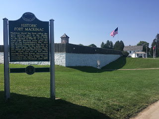
What is now Mackinac Island State Park was originally the second National Park after Yellowstone. Mackinac Island National Park was in place from 1875 to 1895 when it was transferred back to the state of Michigan. Really with the volume of things to do on the island and all the history it is no wonder to me that it was one of the first National Parks. I went to; Arch Rock, Fort Holmes, Fort Mackinac, The Grand Hotel, and cruised the city to find ice cream before departing for the day. Supposedly I got 5.6 miles of hiking in through the core of the island after I dropped off the bike.


Had a hell of a view from the hotel room to enjoy the rest of the night as I was editing photos.


I grabbed a 7-speed bike near the ferry dock and got started on M-185 traveling island counter-clockwise. M-185 is a state highway maintained solely for non-motorized traffic and is primarily known as a bike route. M-185 is approximately eight miles in length and only has two shields; one in each direction next to Marquette Park. M-185 is known as Main Street in the city of Mackinac Island and Lake Shore Road around the rest of the island. The road that became M-185 was built from 1900 to 1910 and was assigned a trunkline number in 1933. M-185 is open to emergency vehicles but otherwise motorized traffic is completely prohibited. My bike sucked (it kept dropping 6th gear) but it did give me some extra speed over the single-speed cruisers, I've done a distance biking in my time and slow wasn't coming to cut it.


What is now Mackinac Island State Park was originally the second National Park after Yellowstone. Mackinac Island National Park was in place from 1875 to 1895 when it was transferred back to the state of Michigan. Really with the volume of things to do on the island and all the history it is no wonder to me that it was one of the first National Parks. I went to; Arch Rock, Fort Holmes, Fort Mackinac, The Grand Hotel, and cruised the city to find ice cream before departing for the day. Supposedly I got 5.6 miles of hiking in through the core of the island after I dropped off the bike.


Had a hell of a view from the hotel room to enjoy the rest of the night as I was editing photos.

Comments