
Great Lakes Road Trip Day 7 Part 1; Clinching M-26

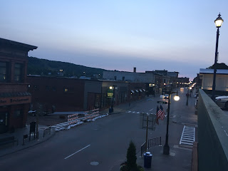
I started the morning in Houghton just as the sun was coming up.  I had a pretty decent view of US 41 northbound on Shelden Avenue and the Portage Lake Lift Bridge from the hotel.


My understanding is that M-26 used to go directly through Atlantic Mine but the modern highway bypasses it.  The next major inhabited location south of Atlantic Mine and Houghton is South Range.  South Range was settled in 1902 and incorporated in 1906 with said name because it was at the southern end of the copper mining district in the Keweenaw Peninsula. 


South of South Range is Trimountain and Painesdale.  At least in the case of Painesdale it was built for the Champion Mine in 1889 which operated nearby.  


The next community southbound is Toivola which was settled in 1845.  Toilova was originally a logging town but became a stop on Copper Range Railroad which operated from 1899 to 1972.


South of Toivola is the ghost town Donken.  Donken appears to have never been much more than a rail siding for the Copper Range Railroad.  Supposedly postal service operated in Donken from 1919 to some time in the 1930s.  There isn't much left of the town other than a couple abandoned buildings off the side of M-26.


South of Donken M-26 enters Ontonagon County and picks up M-38 for about a mile before splitting off towards Mass City. 


Mass City was settled in 1848 when copper deposits were found in the area.  Apparently the town was never incorporated but more officially plotted out in the 1850s.  Apparently Mass City takes it's name from the Mass Mining Company which operated the deposits nearby. 


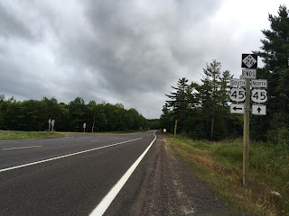
South of Mass City M-26 meets US 45 and terminates.  Before the US Route system M-26 actually used to connect to what was WI 26.  Odd to think that many of the Mid-West states already had well plotted out highway systems before the US Routes that have stood the test of time over the last century.


Comments

Popular posts from this blog

Hawaii Route 8930

Hawaii Route 8930 is a 2.5-mile State Highway on the Island of O'hau.  Hawaii Route 8930 is aligned over Kualakai Parkway over the course of its entire alignment south from Interstate H-1 to Kapolei Parkway.  Hawaii Route 8930 is one of the newest Hawaii Routes only having been completed during 2010.   This page is part of the Gribblenation O'ahu Highways page.  All Gribblenation and Roadwaywiz media related to the highway system of O'ahu can be found at the link below: https://www.gribblenation.org/p/gribblenation-oahu-highways-page.html Part 1; the history of Hawaii Route 8930 The history of Hawaii Route 8930 is brief given it is a modern facility.  Hawaii Route 8930 and what was known as "North-South Road" were built to facilitate the developing areas of Kapolei on western O'ahu.  According to hawaiihighways.com the first stage of Hawaii Route 8930 was completed from Kapolei Parkway north to Farrington Highway as a four-lane highway during November...

Old US Route 60/70 through Hell (Chuckwall Valley Road and Ragsdale Road)

Back in 2016 I explored some of the derelict roadways of the Sonoran Desert of Riverside County which were part of US Route 60/70; Chuckwalla Valley Road and Ragsdale Road. US 60 and US 70 were not part of the original run of US Routes in California.  According to USends.com US 60 was extended into California by 1932.  US 60 doesn't appear on the California State Highway Map until the 1934 edition. USends.com on US 60 endpoints 1934 State Highway Map Conversely US 70 was extended into California by 1934, it first appears on the 1936 State Highway Map. USends.com on US 70 endpoints 1936 State Highway Map When US 60 and US 70 were extended into California they both utilized what was Legislative Route Number 64 from the Arizona State Line west to Coachella Valley.  LRN 64 was part of the 1919 Third State Highway Bond Act routes.  The original definition of LRN 64 routed between Mecca in Blythe and wasn't extended to the Arizona State Line until 1931 acc...

Paper Highways; Interstate H-4 through downtown Honolulu

The Hawaiian Island of O'ahu is home to four Interstate Highways; H-1, H-2, H-3 and H-201.  Had history gone slightly differently during the 1960s a fifth Interstate corridor on O'ahu could have been constructed through downtown Honolulu and the neighborhood of Waikiki.  The proposed corridor of Interstate H-4 can be seen above as it was presented by the Hawaii Department of Transportation during October 1968 .   This page is part of the Gribblenation O'ahu Highways page.  All Gribblenation and Roadwaywiz media related to the highway system of O'ahu can be found at the link below: https://www.gribblenation.org/p/gribblenation-oahu-highways-page.html The history of proposed Interstate H-4 The corridor of Interstate H-4 was conceived as largely following what is now Hawaii Route 92 on Nimitz Highway and Ala Moana Boulevard.   Prior to the Statehood the first signed highways within Hawaii Territory came into existence during World War II.    Dur...