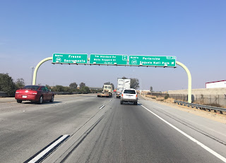
After leaving Bakersfield I decided to take a mountain side way back to Fresno and turned off CA 99 onto the southern portion of California State Route 65.
CA 65 was one of the original 1934 signed state highways. Back in 1934 CA 65 ran from US 99 north to CA 180/Dunlap Road near General Grant National Park. CA 65 is now a split route with a large unbuilt segment in between the two sections, the portion north of CA 198 is now CA 245. All of CA 65 from US 99 north to CA 180 was part of Legislative Route Number 129 which was established in 1929. CA 65 has a ton of alignment changes, renumbering and general shifts so I'll cover that at the end of this blog. For now CAhighways.org covers the changes and history of CA 65 pretty well if you feel like reading it in advance.
CAhighways.org on CA 65
CAhighways.org on LRN 129
CA 65 northbound begins at the outskirts of Bakersfield in Kern County. CA 65 is briefly an expressway before dropping to a two-lane segment through the oilfields of the Sierra Foothills. CA 65 north pretty all the way to Porterville is designated as a Safety Corridor.

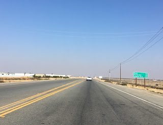

Kind of interesting seem all the oil derricks surrounding CA 65. The last time I was through this stretch of 65 was back in 2012 during a heavy fog which obstructed the view.


CA 65 junctions CA 155 on the Graces Highway. Ironically CA 155 used to end near Bakersfield while CA 65 had a much more northward south terminus in Famaso.


After a big dip in the road, CA 65 enters Tulare County.


As CA 65 approaches the White River railroad tracks along with Richgrove Drive/Signed County Route J35 can be seen. At the White River bank is an abandoned highway bridge that used to be part of CA 65 along Richgrove Drive.

The above bridge is part of an important alignment shift of CA 65. Originally CA 65 began from US 99 in Famaso using the Famaso-Porterville Highway north to Tulare County where it became Richgrove Drive. Richgrove Drive continued over the modern alignment of CA 65 becoming Avenue 236 in Ducor. This alignment is clear on the 1935 California Divisions of Highway Map for Kern County and the 1938 State Highway Map.
1935 Kern County Highway Map
1938 State Highway Map
CA 65 used to be a much more urbanized route from Ducor north to Lindsay. CAhighways.org provides the former alignment between Ducor and Lindsay at the link I referenced above:
"The following portions of Route 65 were bypassed by freeway or expressway:
With all that mind, back to the road album portion of the blog.... CA 65 travels under the rails on an underpass.

If you read the CA 43 blog then you already know that Avenue 56 was part of LRN 135 and is currently part of the unsigned County Route J22. LRN 135 ran from Ducor northwest to Hanford while J22 runs directly west to Alpaugh and County Route J33


CA 65 north to Terra Bela is largely still two-lanes.


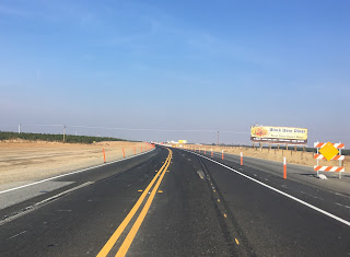
North of Terra Bela CA 65 has an active construction project widening the highway out to an expressway to CA 190 in Porterville.


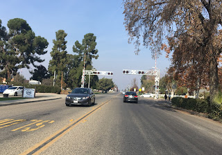
Through Porterville CA 65 is a freeway which drops down to a four-lane expressway in Lindsay.


North of Lindsay CA 65 drops to two-lanes on a brief western jog before turning north again towards Exeter at the junction of CA 137.


The rest of CA 65 north through Exeter to CA 198 is pretty straight-forward. I do recall back in 2012 stopping at the water tower in downtown Exeter to grab a soda before heading up CA 245 to reach Kings Canyon National Park. I want to say the Generals Highway was undergoing a major widening at the time which is how I accidentally discovered CA 245 which is now one of my favorite driving roads. The north end of CA 65 even has an "end" placard.


Of course as I mentioned previously and is obvious on the 1938 State Highway Map, CA 65 used to continue north of CA 198 to CA 180. That particular segment of former CA 65 is now CA 245 which I did take a photo album of earlier in the year (and it is on my future blog list given how awesome it is).
CA 245 Photo Album
By 1942 the north terminus of CA 65 shifted when CA 180 was moved north onto it's modern alignment off of Dunlap Road.
1942 State Highway Map
By 1948 the southern terminus of CA 65 was shifted away from Famaso onto it's modern alignment near Bakersfield. The former alignment from Famaso to Ducor became LRN 136.
1948 State Highway Map
By 1957 the freeway alignment of CA 65 in Porterville is show complete.
1957 State Highway Map
By 1960 LRN 249 appears on state highway maps connecting CA 65 from CA 198 northwest to US 99E near Sacramento. LRN 249 apparently was designed to be an alternate to US 99 and ultimately is the reason why CA 65 now has two segments. LRN 249 was defined in 1959 according to CAhighways.org as noted above on the CA 65 link.
1960 State Highway Map
By 1964 LRN 136 had been renumbered to CA 211, LRN 249 to LRN 65, and LRN 69 appears over CA 65 north of CA 198.
1964 State Highway Map
By 1965 CA 69 was designated over what was CA 65 north of CA 198. US 99E is co-signed as the north CA 65 segment.
1965 State Highway Map
By 1967 CA 211 is deleted as a state highway and US 99E is removed in favor of the stand alone northern CA 65. Parts of CA 211 became Signed County Route J35 by 1975. The proposed expressway alignment of CA 65 from Ducor to Terra Bela appears on the map as well. The freeway section of CA 65 in Porterville is shown built, I'm not sure when it was completed.
1967 State Highway Map
By 1969 the expressway bypass of Ducor and Terra Bela is shown as complete.
1969 State Highway Map
In 1972 CA 69 was renumbered to CA 245 which was likely due to sign theft.
CAhighways.org on CA 245
Obviously CA 65 was never finished between CA 198 and Sacramento, it likely never will be. The terrain is largely in the rural Sierra Foothills and it would junction various state highways (including CA 59 in Snelling). At this point the northern segment of CA 65 might as well be renumbered to something else to avoid the duplication.

CA 65 was one of the original 1934 signed state highways. Back in 1934 CA 65 ran from US 99 north to CA 180/Dunlap Road near General Grant National Park. CA 65 is now a split route with a large unbuilt segment in between the two sections, the portion north of CA 198 is now CA 245. All of CA 65 from US 99 north to CA 180 was part of Legislative Route Number 129 which was established in 1929. CA 65 has a ton of alignment changes, renumbering and general shifts so I'll cover that at the end of this blog. For now CAhighways.org covers the changes and history of CA 65 pretty well if you feel like reading it in advance.
CAhighways.org on CA 65
CAhighways.org on LRN 129
CA 65 northbound begins at the outskirts of Bakersfield in Kern County. CA 65 is briefly an expressway before dropping to a two-lane segment through the oilfields of the Sierra Foothills. CA 65 north pretty all the way to Porterville is designated as a Safety Corridor.


Kind of interesting seem all the oil derricks surrounding CA 65. The last time I was through this stretch of 65 was back in 2012 during a heavy fog which obstructed the view.


CA 65 junctions CA 155 on the Graces Highway. Ironically CA 155 used to end near Bakersfield while CA 65 had a much more northward south terminus in Famaso.


After a big dip in the road, CA 65 enters Tulare County.


As CA 65 approaches the White River railroad tracks along with Richgrove Drive/Signed County Route J35 can be seen. At the White River bank is an abandoned highway bridge that used to be part of CA 65 along Richgrove Drive.

The above bridge is part of an important alignment shift of CA 65. Originally CA 65 began from US 99 in Famaso using the Famaso-Porterville Highway north to Tulare County where it became Richgrove Drive. Richgrove Drive continued over the modern alignment of CA 65 becoming Avenue 236 in Ducor. This alignment is clear on the 1935 California Divisions of Highway Map for Kern County and the 1938 State Highway Map.
1935 Kern County Highway Map
1938 State Highway Map
CA 65 used to be a much more urbanized route from Ducor north to Lindsay. CAhighways.org provides the former alignment between Ducor and Lindsay at the link I referenced above:
"The following portions of Route 65 were bypassed by freeway or expressway:
- Orris, Terra Bella, Elmco north to Teapot Dome Avenue in Lois: Road 236 (Road 232 is the current Route 65 expressway)
- Teapot Dome Avenue in Lois to Zante at Avenue 178, passing through downtown
- Porterville: Main Street
- Avenue 178 in Sante north to Avenue 190 in Strathmore: Orange Belt Drive
- Avenue 190 in Strathmore north to Avenue 200 in Strathmore: Depot Drive
- Avenue 200 north to Avenue 216 in Stout: Orange Belt Drive
- Avenue 216 north to Valencia Street in Lindsay: Mirage Drive
- Through Lindsay, the routing is: Elmwood Avenue north to Tulare Road; west on Tulare Road to reconnect with Route 65 (which continues as Tulare Road west to the Route 137 junction at Cairns Corner.)"
With all that mind, back to the road album portion of the blog.... CA 65 travels under the rails on an underpass.

If you read the CA 43 blog then you already know that Avenue 56 was part of LRN 135 and is currently part of the unsigned County Route J22. LRN 135 ran from Ducor northwest to Hanford while J22 runs directly west to Alpaugh and County Route J33


CA 65 north to Terra Bela is largely still two-lanes.


North of Terra Bela CA 65 has an active construction project widening the highway out to an expressway to CA 190 in Porterville.


Through Porterville CA 65 is a freeway which drops down to a four-lane expressway in Lindsay.


North of Lindsay CA 65 drops to two-lanes on a brief western jog before turning north again towards Exeter at the junction of CA 137.


The rest of CA 65 north through Exeter to CA 198 is pretty straight-forward. I do recall back in 2012 stopping at the water tower in downtown Exeter to grab a soda before heading up CA 245 to reach Kings Canyon National Park. I want to say the Generals Highway was undergoing a major widening at the time which is how I accidentally discovered CA 245 which is now one of my favorite driving roads. The north end of CA 65 even has an "end" placard.


Of course as I mentioned previously and is obvious on the 1938 State Highway Map, CA 65 used to continue north of CA 198 to CA 180. That particular segment of former CA 65 is now CA 245 which I did take a photo album of earlier in the year (and it is on my future blog list given how awesome it is).
CA 245 Photo Album
By 1942 the north terminus of CA 65 shifted when CA 180 was moved north onto it's modern alignment off of Dunlap Road.
1942 State Highway Map
By 1948 the southern terminus of CA 65 was shifted away from Famaso onto it's modern alignment near Bakersfield. The former alignment from Famaso to Ducor became LRN 136.
1948 State Highway Map
By 1957 the freeway alignment of CA 65 in Porterville is show complete.
1957 State Highway Map
By 1960 LRN 249 appears on state highway maps connecting CA 65 from CA 198 northwest to US 99E near Sacramento. LRN 249 apparently was designed to be an alternate to US 99 and ultimately is the reason why CA 65 now has two segments. LRN 249 was defined in 1959 according to CAhighways.org as noted above on the CA 65 link.
1960 State Highway Map
By 1964 LRN 136 had been renumbered to CA 211, LRN 249 to LRN 65, and LRN 69 appears over CA 65 north of CA 198.
1964 State Highway Map
By 1965 CA 69 was designated over what was CA 65 north of CA 198. US 99E is co-signed as the north CA 65 segment.
1965 State Highway Map
By 1967 CA 211 is deleted as a state highway and US 99E is removed in favor of the stand alone northern CA 65. Parts of CA 211 became Signed County Route J35 by 1975. The proposed expressway alignment of CA 65 from Ducor to Terra Bela appears on the map as well. The freeway section of CA 65 in Porterville is shown built, I'm not sure when it was completed.
1967 State Highway Map
By 1969 the expressway bypass of Ducor and Terra Bela is shown as complete.
1969 State Highway Map
In 1972 CA 69 was renumbered to CA 245 which was likely due to sign theft.
CAhighways.org on CA 245
Obviously CA 65 was never finished between CA 198 and Sacramento, it likely never will be. The terrain is largely in the rural Sierra Foothills and it would junction various state highways (including CA 59 in Snelling). At this point the northern segment of CA 65 might as well be renumbered to something else to avoid the duplication.
Comments