During a foggy winter morning in December of 2017 I decided to tackle California State Route 43.

California State Route 43 ("CA 43") is a 98 mile long north/south State Highway traversing the center of San Joaquin Valley over much of the watershed of area that used to feed Tulare Lake. The Tule Fog was dense in places during the winter of 2017 which spiced up CA 43 enough to warrant a trip to it's south terminus.


Part 1; a drive on California State Route 43
The north terminus of CA 43 is in the city of Selma in Fresno County at the junction of CA 99. I was heading south out of Fresno thus my starting point on CA 43 was in Selma. The Tule Fog was thick by the CA 99 freeway tends to clear it a little bit due to the heat of the vehicles.


CA 43 really doesn't have a major town at it's southern terminus hence why Wasco is signed at 71 miles to the south instead of CA 119 at 98 miles.
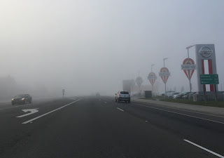
The Tule Fog was especially thick between Selma and Corcoran. Tule Fog season in San Joaquin Valley is typically between November 1st to March 31st during the wet season. Tule Fog tends to stick low to the ground and is caused by high humidity coupled with rapid overnight temperature decreases. The Tule Fog is especially bad the week after a significant rain storm as the humidity and soil in the farm lands tends to be wet. I've often found the Tule Fog to be the worst in spots in and around the low lying areas on San Joaquin Valley near the Tulare Lake bed between Corcoran and Kettleman City.

Just north of the Kings River CA 43 enters Kings County. The asphalt quality was substantially higher on the Kings County section of 43 as opposed to Fresno County.

Upon entering Kings County CA 43 south crosses two branches of the Kings River.


Hanford is the largest city on CA 43 at about 56,000 residents. CA 43 largely bypasses the city of Hanford to the east.


CA 43 passes over a railroad track and approaches a relatively new oundabout at Lacey Boulevard. Lacey Boulevard is the former alignment of CA 198.


Corcoran is signed as 16 miles south of the CA 198 freeway. Luckily the traffic on CA 43 tends to drop south of Hanford which was a good thing considering the fog picked up back up.

CA 43 bypasses Corcoran to the northeast much like it does with Hanford. Corcoran dates back to as early as 1905 with an incorporation dating back to 1914. At 207 feet above sea level Corcoran would have been just below spill crest of the former Tulare Lake which was located directly west of the city. Corcoran is currently experiencing a population boom due to the California State Prison located in the city. The city of Corcoran has approximately 25,000 residents but about 40% are prisoners.


Tulare Lake was once the largest freshwater lake west of the Mississippi River with a maximum surface area of approximately 690 square miles. Tulare Lake was essentially at a low point of San Joaquin Valley where waters from the; Kings River, St. Johns River, Kaweah River, Tule River, White River, and Kern River drained out of the Sierra Nevada Range into. When Tulare Lake reached a height of 210 feet above sea it would drain via Fresno Slough northwest into the San Joaquin River. Agriculture division coupled with upstream reservoirs essentially drove Tulare Lake to dry out and it largely disappears from most maps of California after 1930.
At Whitley Avenue CA 43 meets the junction of CA 137 at a roundabout.


South of Corcoran CA 43 crosses the Tule River and enters Tulare County. The next inhabited town on CA 43 south is Wasco 26 miles away from the County Line.

Much of what is now CA 43 was once part of Legislative Route 135 ("LRN 135") which ran from Ducor northwest to Hanford. LRN 135 used to utilize Avenue 56 east through Earlimart where it intersected US 99/LRN 4. LRN 135 continued east from Earlimart towards LRN 136 in Ducor.


Avenue 56 is now part of Sign County Route J22 which runs from Road 38/Signed County Route J33 in Alpaugh east CA 65 in Ducor. J22 was created in 1968 but isn't signed much like almost every other Tulare Sign County Route. J33 runs from J22 in Alpaugh north to CA 43 via Avenue 112 and was created in 1975. J33 is no exception to the neglect in the Tulare County portion of the Sign County Route program and isn't signed.

Between Corcoran and Wasco is the ghost town of Allensworth which is located on the west side of the BNSF railroad running next to CA 43. Allensworth was on the far eastern banks of Tulare Lake and was founded in 1908 and is named after Colonial Allen Allensworth a freed slave who served in the Civil War. Allensworth was the apparently the only town in California that was built, governed, and completely populated by African Americans. Allensworth's water supply became poisoned by arsenic in the ground water in the 1950s which led to the the town declining. Allensworth became a State Historic Park in the 1970s..


Amtrak Service actually still runs to Allensworth and the station next to the park entrance isn't a display piece. Apparently you have to make special arrangements for Amtrak to drop you off in Allensworth and it isn't listed as a regularly scheduled stop.
South of Allensworth CA 43 enters Kern County. At the Graces Highway traffic can access the Kern National Wildlife Refuge. The Refuge is a habitat restoration for the wetlands that waters from the Kern River would drain through to reach Tulare Lake. Apparently the refuge is just for water fowl and doesn't have any Tule Elk which used to inhabit San Joaquin Valley.


At Pond Road CA 43 passes through the community of Pond. Apparently Pond dates back to the late 1880s but seems to be in a steep decline towards becoming a ghost town with lots of abandoned buildings.


CA 43 meets CA 46 in Wasco and multiplexes eastbound under the railroad tracks before splitting south through downtown.


Wasco dates back to 1899 when it was called Deweyville. Apparently the name of the town changed to Wasco in 1900 and may have been named after a sugar company or a county of the same name in Oregon.

South of Wasco CA 43 widens to an expressway to Shafter.


Shafter was founded as a railroad siding on the Santa Fe lines in the 1890s. The city essentially has become an outskirt of the Bakersfield area and has an approximate population of 19,000.

Exiting Shafter CA 43 cuts south off from Santa Fe Way towards I-5. Guide signs begin to display control cities not even on CA 43.


After crossing a series of rails CA 43 picks up the east/west CA 58 briefly at Blue Star Highway before it cuts towards Bakersfield at Rosedale Highway.


CA 43 crosses another set of rails before meeting the Stockdale Highway. This segment will eventually become part of CA 58 once the Westside Parkway project is completed all the way to CA 99.


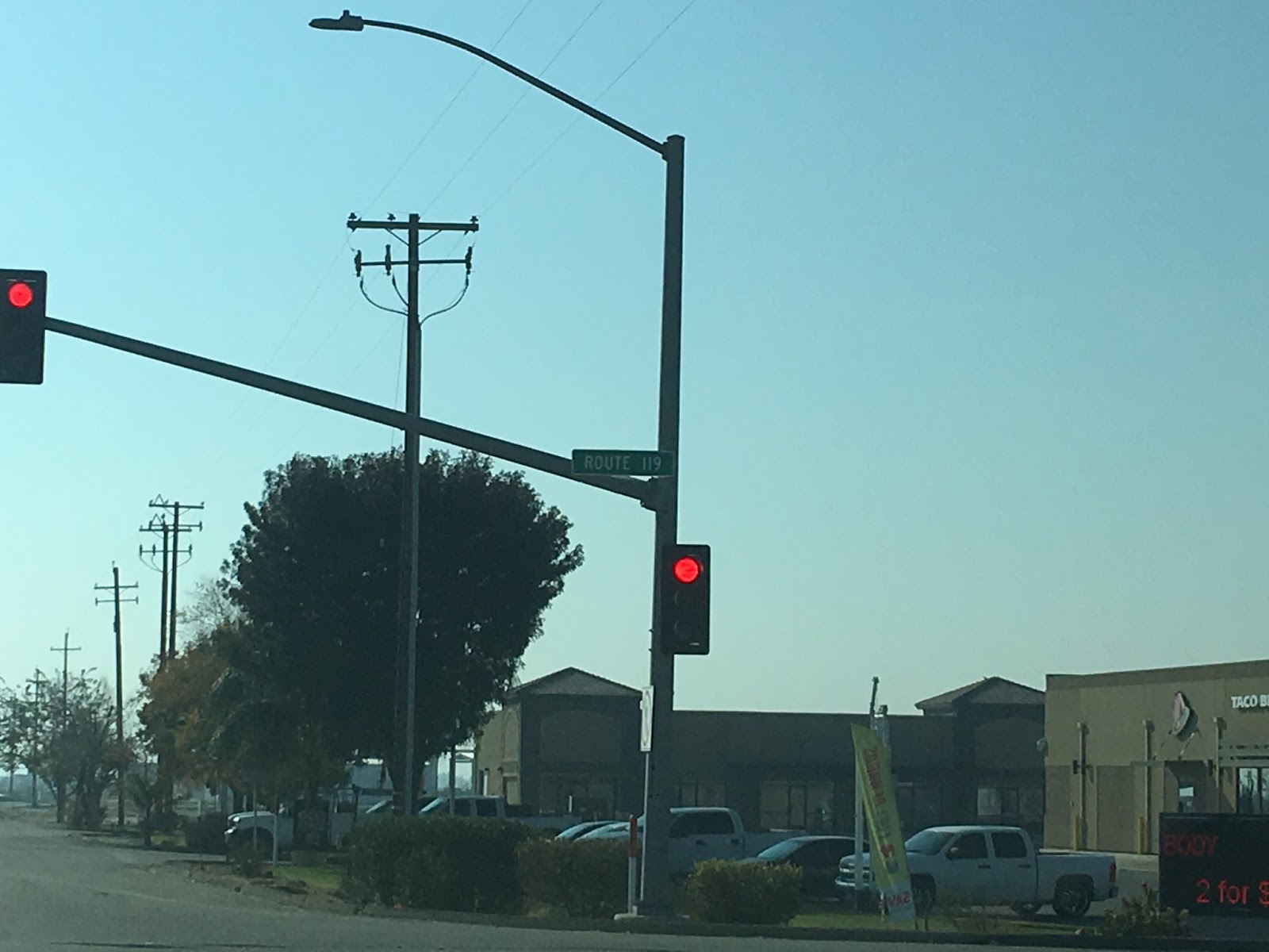
South of Stockdale Highway CA 43 crosses I-5 before ending at CA 119. There is no signage indicating that CA 43 has ended or that you are at the junction of CA 119 aside from street blades.


Part 2; the history of California State Route 43
As stated previously one the precursor routes to CA 43 was LRN 135, but what was LRN 139 was comprised into the modern highway. LRN 135 ran from Lacey Boulevard (the original CA 198 alignment) and 10th Avenue in Hanford southeast to Ducor via Avenue 56 to Road 236 (the original CA 65). LRN 139 ran from US 466 (modern CA 46) in Wasco south to US 399 (modern CA 119). Both early alignments of LRN 135 and LRN 139 can be seen on the 1938 Division of Highways State Map.

According to CAhighways.org both LRN 135 and LRN 139 were added to the State Highway System in 1933.
CAhighways.org on LRN 139
CAhighways.org on LRN 135
By 1953 the alignment of LRN 135 was shifted onto the modern routing of CA 43. LRN 135 can be seen bypassing Corcoran to the northeast like CA 43 does today to a terminus at CA 198/Lacey Boulevard via 7th Avenue where the above roundabout is located today. This change can be seen on the 1953 Division of Highways State Map.

Originally LRN 135 north from Corcoran used; Santa Fe Avenue, Whitley Avenue, 10th Avenue, 10 1/2th Avenue, Kansas Avenue, and 10th Avenue to reach CA 198/Lacey Boulevard in Hanford. This segment of LRN 135 will be discussed in Part 3.
By 1954 LRN 135 was extended south from Avenue 56 to Wasco. The alignment on Avenue 56 was deleted from the state Highway system. According to CAhighways.org the definition of LRN 135 was changed in 1953 to have a south terminus in Wasco.

By 1960 an extension of LRN 135 south from US 99 out of Selma to the Kings County line is shown built. It seems highway traffic was directed onto 10th Avenue which was maintained at the local level to Lacey Boulevard/CA 198 east to 7th Avenue to continue on LRN 135 south.

By 1962 the modern bypass of Hanford was completed as an extension in that connected the gap in LRN 135.

By 1963 all of LRN 135 and LRN 139 were signed as CA 43.

It appears that LRN 139 used to run on Wasco Avenue south from US 466 and cut west over the BNSF Railroad via Kimberlina Road on it's original alignment. This early alignment of LRN 139 can be seen on the 1935 Divisions of Highways Map of Kern County.

Part 3; a drive on former Legislative Route 135 between Hanford and Corcorcan
During the summer of 2020 I found myself in Hanford for a dentist appointment. That being the case I decided to drive the original route of LRN 135 between Hanford and Corcoran. I began my drive from former CA 198 east on Lacey Boulevard and made a southbound turn onto former LRN 135 at 10th Avenue.

Former LRN 135 on 10th Avenue passes over the CA 198 freeway between 4th Street and 3rd Street.


Former LRN 135 on 10th Avenue becomes a two lane highway at 3rd Street. 10th Avenue south passes by the Kings County Fairground and Hanford Cemetery.


Former LRN 135/10th Avenue exits the City of Hanford at Hanford-Armona Road.

Former LRN 135/10th Avenue south passes through the community of Home Garden approaching Houston Avenue.


Former LRN 135 follows 10th Avenue south for approximately 6 miles to the former ATSF siding of Guernsey. At Guernsey former LRN 135 south made a right hand turn onto Kansas Avenue. All that remains of Guernsey today is a derelict bar at the intersection of 10th Avenue and Kansas Avenue.


Former LRN 135/Kansas Avenue crosses over the BNSF freight like in Guernsey where I encountered the San Joaquin Amtrak/Caltrans Line. Amtrak and Caltrans operate three passenger Lines within California, the San Joaquin operates from Bakersfield north to Stockton on the BNSF freight line. The San Joaquin from Stockton has two spur lines; one west to Oakland via the Carquinez Strait, the other north to Sacramento. The San Joaquin line began service in March 1974 and has just over 1 million passengers annually. In the last photo below a Siemens Charger diesel-electric locomotive can be seen pulling Amtrak cars north towards Hanford.


Former LRN 135 turned south from Kansas Avenue onto 10th 1/2 Avenue just west of Guernsey.


Former LRN 135 followed 10th 1/2 Avenue south for 8 miles to the eastern shore of Tulare Lake (or what was Tulare Lake) to Whitley Avenue. At Whitley Avenue former LRN 135 turned east towards Corcoran.


Former LRN 135 east on Whitley Avenue crosses over a 1940s/1950s era Division of Highways Bridge.


Former LRN 135 followed Whitley Avenue east into downtown Corcoran.


Corcoran Station can be found at the northeast corner of Whitley Avenue and Otis Avenue. The current Corcoran Station opened in 1989 and was a replacement for the 1907 ATSF Station which was at the same location.


Former LRN 135 crossed the BNSF Freight Line on Whitley Avenue where it turned south to Santa Fe Avenue via Pickerell Avenue.


Former LRN 135 south on Santa Fe Avenue crossed another 1940s/1950s era Division of Highways Bridge over Sweet Canal.


Former LRN 135 and Santa Fe Avenue merge into modern CA 43 near 4th Avenue.


California State Route 43 ("CA 43") is a 98 mile long north/south State Highway traversing the center of San Joaquin Valley over much of the watershed of area that used to feed Tulare Lake. The Tule Fog was dense in places during the winter of 2017 which spiced up CA 43 enough to warrant a trip to it's south terminus.


Part 1; a drive on California State Route 43
The north terminus of CA 43 is in the city of Selma in Fresno County at the junction of CA 99. I was heading south out of Fresno thus my starting point on CA 43 was in Selma. The Tule Fog was thick by the CA 99 freeway tends to clear it a little bit due to the heat of the vehicles.


CA 43 really doesn't have a major town at it's southern terminus hence why Wasco is signed at 71 miles to the south instead of CA 119 at 98 miles.

The Tule Fog was especially thick between Selma and Corcoran. Tule Fog season in San Joaquin Valley is typically between November 1st to March 31st during the wet season. Tule Fog tends to stick low to the ground and is caused by high humidity coupled with rapid overnight temperature decreases. The Tule Fog is especially bad the week after a significant rain storm as the humidity and soil in the farm lands tends to be wet. I've often found the Tule Fog to be the worst in spots in and around the low lying areas on San Joaquin Valley near the Tulare Lake bed between Corcoran and Kettleman City.

Just north of the Kings River CA 43 enters Kings County. The asphalt quality was substantially higher on the Kings County section of 43 as opposed to Fresno County.

Upon entering Kings County CA 43 south crosses two branches of the Kings River.


Hanford is the largest city on CA 43 at about 56,000 residents. CA 43 largely bypasses the city of Hanford to the east.


CA 43 passes over a railroad track and approaches a relatively new oundabout at Lacey Boulevard. Lacey Boulevard is the former alignment of CA 198.


Corcoran is signed as 16 miles south of the CA 198 freeway. Luckily the traffic on CA 43 tends to drop south of Hanford which was a good thing considering the fog picked up back up.

CA 43 bypasses Corcoran to the northeast much like it does with Hanford. Corcoran dates back to as early as 1905 with an incorporation dating back to 1914. At 207 feet above sea level Corcoran would have been just below spill crest of the former Tulare Lake which was located directly west of the city. Corcoran is currently experiencing a population boom due to the California State Prison located in the city. The city of Corcoran has approximately 25,000 residents but about 40% are prisoners.


Tulare Lake was once the largest freshwater lake west of the Mississippi River with a maximum surface area of approximately 690 square miles. Tulare Lake was essentially at a low point of San Joaquin Valley where waters from the; Kings River, St. Johns River, Kaweah River, Tule River, White River, and Kern River drained out of the Sierra Nevada Range into. When Tulare Lake reached a height of 210 feet above sea it would drain via Fresno Slough northwest into the San Joaquin River. Agriculture division coupled with upstream reservoirs essentially drove Tulare Lake to dry out and it largely disappears from most maps of California after 1930.
At Whitley Avenue CA 43 meets the junction of CA 137 at a roundabout.


South of Corcoran CA 43 crosses the Tule River and enters Tulare County. The next inhabited town on CA 43 south is Wasco 26 miles away from the County Line.

Much of what is now CA 43 was once part of Legislative Route 135 ("LRN 135") which ran from Ducor northwest to Hanford. LRN 135 used to utilize Avenue 56 east through Earlimart where it intersected US 99/LRN 4. LRN 135 continued east from Earlimart towards LRN 136 in Ducor.


Avenue 56 is now part of Sign County Route J22 which runs from Road 38/Signed County Route J33 in Alpaugh east CA 65 in Ducor. J22 was created in 1968 but isn't signed much like almost every other Tulare Sign County Route. J33 runs from J22 in Alpaugh north to CA 43 via Avenue 112 and was created in 1975. J33 is no exception to the neglect in the Tulare County portion of the Sign County Route program and isn't signed.

Between Corcoran and Wasco is the ghost town of Allensworth which is located on the west side of the BNSF railroad running next to CA 43. Allensworth was on the far eastern banks of Tulare Lake and was founded in 1908 and is named after Colonial Allen Allensworth a freed slave who served in the Civil War. Allensworth was the apparently the only town in California that was built, governed, and completely populated by African Americans. Allensworth's water supply became poisoned by arsenic in the ground water in the 1950s which led to the the town declining. Allensworth became a State Historic Park in the 1970s..


Amtrak Service actually still runs to Allensworth and the station next to the park entrance isn't a display piece. Apparently you have to make special arrangements for Amtrak to drop you off in Allensworth and it isn't listed as a regularly scheduled stop.
South of Allensworth CA 43 enters Kern County. At the Graces Highway traffic can access the Kern National Wildlife Refuge. The Refuge is a habitat restoration for the wetlands that waters from the Kern River would drain through to reach Tulare Lake. Apparently the refuge is just for water fowl and doesn't have any Tule Elk which used to inhabit San Joaquin Valley.


At Pond Road CA 43 passes through the community of Pond. Apparently Pond dates back to the late 1880s but seems to be in a steep decline towards becoming a ghost town with lots of abandoned buildings.


CA 43 meets CA 46 in Wasco and multiplexes eastbound under the railroad tracks before splitting south through downtown.


Wasco dates back to 1899 when it was called Deweyville. Apparently the name of the town changed to Wasco in 1900 and may have been named after a sugar company or a county of the same name in Oregon.

South of Wasco CA 43 widens to an expressway to Shafter.


Shafter was founded as a railroad siding on the Santa Fe lines in the 1890s. The city essentially has become an outskirt of the Bakersfield area and has an approximate population of 19,000.

Exiting Shafter CA 43 cuts south off from Santa Fe Way towards I-5. Guide signs begin to display control cities not even on CA 43.


After crossing a series of rails CA 43 picks up the east/west CA 58 briefly at Blue Star Highway before it cuts towards Bakersfield at Rosedale Highway.


CA 43 crosses another set of rails before meeting the Stockdale Highway. This segment will eventually become part of CA 58 once the Westside Parkway project is completed all the way to CA 99.


South of Stockdale Highway CA 43 crosses I-5 before ending at CA 119. There is no signage indicating that CA 43 has ended or that you are at the junction of CA 119 aside from street blades.


Part 2; the history of California State Route 43
As stated previously one the precursor routes to CA 43 was LRN 135, but what was LRN 139 was comprised into the modern highway. LRN 135 ran from Lacey Boulevard (the original CA 198 alignment) and 10th Avenue in Hanford southeast to Ducor via Avenue 56 to Road 236 (the original CA 65). LRN 139 ran from US 466 (modern CA 46) in Wasco south to US 399 (modern CA 119). Both early alignments of LRN 135 and LRN 139 can be seen on the 1938 Division of Highways State Map.

According to CAhighways.org both LRN 135 and LRN 139 were added to the State Highway System in 1933.
CAhighways.org on LRN 139
CAhighways.org on LRN 135
By 1953 the alignment of LRN 135 was shifted onto the modern routing of CA 43. LRN 135 can be seen bypassing Corcoran to the northeast like CA 43 does today to a terminus at CA 198/Lacey Boulevard via 7th Avenue where the above roundabout is located today. This change can be seen on the 1953 Division of Highways State Map.

Originally LRN 135 north from Corcoran used; Santa Fe Avenue, Whitley Avenue, 10th Avenue, 10 1/2th Avenue, Kansas Avenue, and 10th Avenue to reach CA 198/Lacey Boulevard in Hanford. This segment of LRN 135 will be discussed in Part 3.
By 1954 LRN 135 was extended south from Avenue 56 to Wasco. The alignment on Avenue 56 was deleted from the state Highway system. According to CAhighways.org the definition of LRN 135 was changed in 1953 to have a south terminus in Wasco.

By 1960 an extension of LRN 135 south from US 99 out of Selma to the Kings County line is shown built. It seems highway traffic was directed onto 10th Avenue which was maintained at the local level to Lacey Boulevard/CA 198 east to 7th Avenue to continue on LRN 135 south.

By 1962 the modern bypass of Hanford was completed as an extension in that connected the gap in LRN 135.

By 1963 all of LRN 135 and LRN 139 were signed as CA 43.

It appears that LRN 139 used to run on Wasco Avenue south from US 466 and cut west over the BNSF Railroad via Kimberlina Road on it's original alignment. This early alignment of LRN 139 can be seen on the 1935 Divisions of Highways Map of Kern County.

Part 3; a drive on former Legislative Route 135 between Hanford and Corcorcan
During the summer of 2020 I found myself in Hanford for a dentist appointment. That being the case I decided to drive the original route of LRN 135 between Hanford and Corcoran. I began my drive from former CA 198 east on Lacey Boulevard and made a southbound turn onto former LRN 135 at 10th Avenue.

Former LRN 135 on 10th Avenue passes over the CA 198 freeway between 4th Street and 3rd Street.


Former LRN 135 on 10th Avenue becomes a two lane highway at 3rd Street. 10th Avenue south passes by the Kings County Fairground and Hanford Cemetery.


Former LRN 135/10th Avenue exits the City of Hanford at Hanford-Armona Road.

Former LRN 135/10th Avenue south passes through the community of Home Garden approaching Houston Avenue.


Former LRN 135 follows 10th Avenue south for approximately 6 miles to the former ATSF siding of Guernsey. At Guernsey former LRN 135 south made a right hand turn onto Kansas Avenue. All that remains of Guernsey today is a derelict bar at the intersection of 10th Avenue and Kansas Avenue.


Former LRN 135/Kansas Avenue crosses over the BNSF freight like in Guernsey where I encountered the San Joaquin Amtrak/Caltrans Line. Amtrak and Caltrans operate three passenger Lines within California, the San Joaquin operates from Bakersfield north to Stockton on the BNSF freight line. The San Joaquin from Stockton has two spur lines; one west to Oakland via the Carquinez Strait, the other north to Sacramento. The San Joaquin line began service in March 1974 and has just over 1 million passengers annually. In the last photo below a Siemens Charger diesel-electric locomotive can be seen pulling Amtrak cars north towards Hanford.


Former LRN 135 turned south from Kansas Avenue onto 10th 1/2 Avenue just west of Guernsey.


Former LRN 135 followed 10th 1/2 Avenue south for 8 miles to the eastern shore of Tulare Lake (or what was Tulare Lake) to Whitley Avenue. At Whitley Avenue former LRN 135 turned east towards Corcoran.


Former LRN 135 east on Whitley Avenue crosses over a 1940s/1950s era Division of Highways Bridge.


Former LRN 135 followed Whitley Avenue east into downtown Corcoran.


Corcoran Station can be found at the northeast corner of Whitley Avenue and Otis Avenue. The current Corcoran Station opened in 1989 and was a replacement for the 1907 ATSF Station which was at the same location.


Former LRN 135 crossed the BNSF Freight Line on Whitley Avenue where it turned south to Santa Fe Avenue via Pickerell Avenue.


Former LRN 135 south on Santa Fe Avenue crossed another 1940s/1950s era Division of Highways Bridge over Sweet Canal.


Former LRN 135 and Santa Fe Avenue merge into modern CA 43 near 4th Avenue.


Comments