
The day after driving the paved portion of Arizona State Route 88/the Apache Trail it was time to start heading back home towards California. Driving Interstate 10 west of Phoenix seemed cliche and boring so I opted to drive to the western terminus of US Route 60 instead.
This article serves as the 28th entry and Finale of the 2016 Fall Mountain Trip Series. Part 27 covers the history of AZ 88 and the Apache Trail.2016 Fall Mountain Trip Part 27; Arizona State Route 88 the Apache Trail
The Sonoran Desert west of Phoenix is a largely open and hostile landscape filled with few traces of civilization. This corner of the Sonoran Desert is so desolate that it wasn't a favored route of transportation between Central Arizona, the Colorado River, and the Coastal Areas of California until fairly modern times. Most paths of travel were either routed to the south along the general corridor of what would become US Route 80 or to the north along what would become US Route 66 in the Mojave Desert.
Modernized transportation to the Sonoran Desert of western Arizona dates back to the days of the Bradshaw Trail which was a wagon road through the Sonoran Desert east to the Colorado River. During the California Gold Rush the Bradshaw Trail was plotted through the Sonoran Desert by William D. Bradshaw. The Bradshaw Trail was plotted in 1862 through the Sonoran Desert east over the Colorado River to a new mining strike found in La Paz, Arizona (now Ehrenburg). Bradshaw consulted the Cahuilla Tribe who advised him of the best route east of the Salton Sink between the Orocopia Mountains and Chocolate Mountains. The Bradshaw Trail despite it's elongated path essentially was the forerunner of what would become modern I-10 from Palm Springs to the City of Blythe. More information regarding the Bradshaw Trail and where to find it can be found on desertusa.com.
Despite the Bradshaw Trail being a path of travel from California to La Paz it didn't do much to bring travelers eastward to the mining claims Central Arizona. That said, a primitive road east of La Paz to the Vulture Mine and Wickenburg did exist and can be seen on the 1874 Asher & Adams Map of Arizona.

It wasn't until the Atchison, Topeka, and Santa Fe Railroad ("ATSF") began construction of the Arizona & California Railway in 1903 that modern transportation as well as civilization found it's way to the western Sonoran Desert of Arizona. The Arizona & California Railway was completed in 1910 and would spawn the numerous sidings that would become part of US Route 60 later in the 20th Century. From the split at Cadiz, California the Arizona & California Railway traveled to Phoenix by way of the following sidings:
- Chubbuck, CA
- Milligan, CA
- Rice, CA
- Vidal, CA
- Earp, CA
- Parker, AZ
- Bouse, AZ
- Vicksburg, AZ
- Salome, AZ
- Wenden, AZ
- Golden, AZ
- Aguila, AZ,
- Matthie, AZ
- Wickenburg, AZ
- Morristown, AZ
- Wittmann, AZ
- Beardsley, AZ
- Glendale, AZ
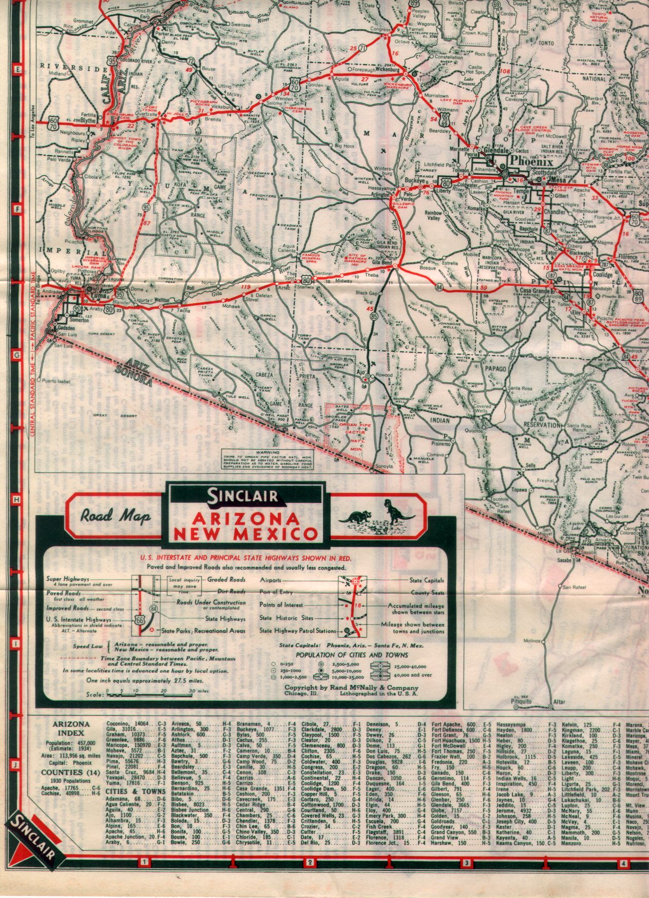
By 1925 a improved road following Grand Avenue west out of Phoenix and current US Route 60 west of Wickenburg to the vicinity of Vicksburg did exist. That said, traffic on the Southern National Highway and Atlantic Pacific Highway followed Salome Highway out of Hassayampa west through Harqua Hala Valley to Salome. The Southern National Highway and Atlantic Pacific Highway followed an ungraded roadway to a ferry which crossed the Colorado River into California. The route of the Southern National Highway and Atlantic Pacific Highway can be seen on the 1925 Rand McNally Map of Arizona/New Mexico.


When the US Route System was approved during November 1926 Grand Avenue west of Phoenix to Wickenburg was selected as the route of US Route 280. US Route 280 would be quickly replaced with an extended US Route 89. The road west of Wickenburg to the Colorado River was not given a US Route nor State Highway designation. US Route 280 on Grand Avenue can be seen on the 1927 Rand McNally Highway Map of Arizona/New Mexico.

According to ArizonaRoads AZ 74 was approved at some point in 1927 as a new State Highway between Wickenburg west to the Colorado River. AZ 74 can be seen in it's original form on the 1931 Clason Highway Map of Arizona/New Mexico.

On the California side of the Colorado River there was actions being taken to build a modern highway through the Sonoran Desert. According to CAhighways.org Legislative Route 64 was added to the State Highway System as part of the 1919 Third State Highway Bond Act routes. The original definition of LRN 64 routed between Mecca in Blythe and wasn't extended to the Arizona State Line until 1931.
CAhighways.org on LRN 64
The construction of a modernized highway from the California and Arizona sides of the Colorado River culminated in the opening the Blythe Bridge in 1931. The completed Blythe Bridge eliminated the need for ferry service over the Colorado River and opened up a fully modern highway. The Bylthe Bridge was a Pratt Truss design and can be seen in this post card.

According to USends in 1932 US Route 60 was extended from Texas to a terminus in downtown Los Angeles. Thusly, US Route 60 was aligned co-signed with US Route 89 on Grand Avenue west from Phoenix to Wickenburg and west on what was AZ 74 to the Colorado River. According to USends 1934 US Route 70 would be extended to Los Angeles as well multiplexed US Route 60 west of Phoenix to the Colorado River. The 1938 Sinclair Road Map of Arizona shows US 60/70/89 co-signed from Phoenix to Wickenburg and US 60/70 co-signed to the Colorado River.

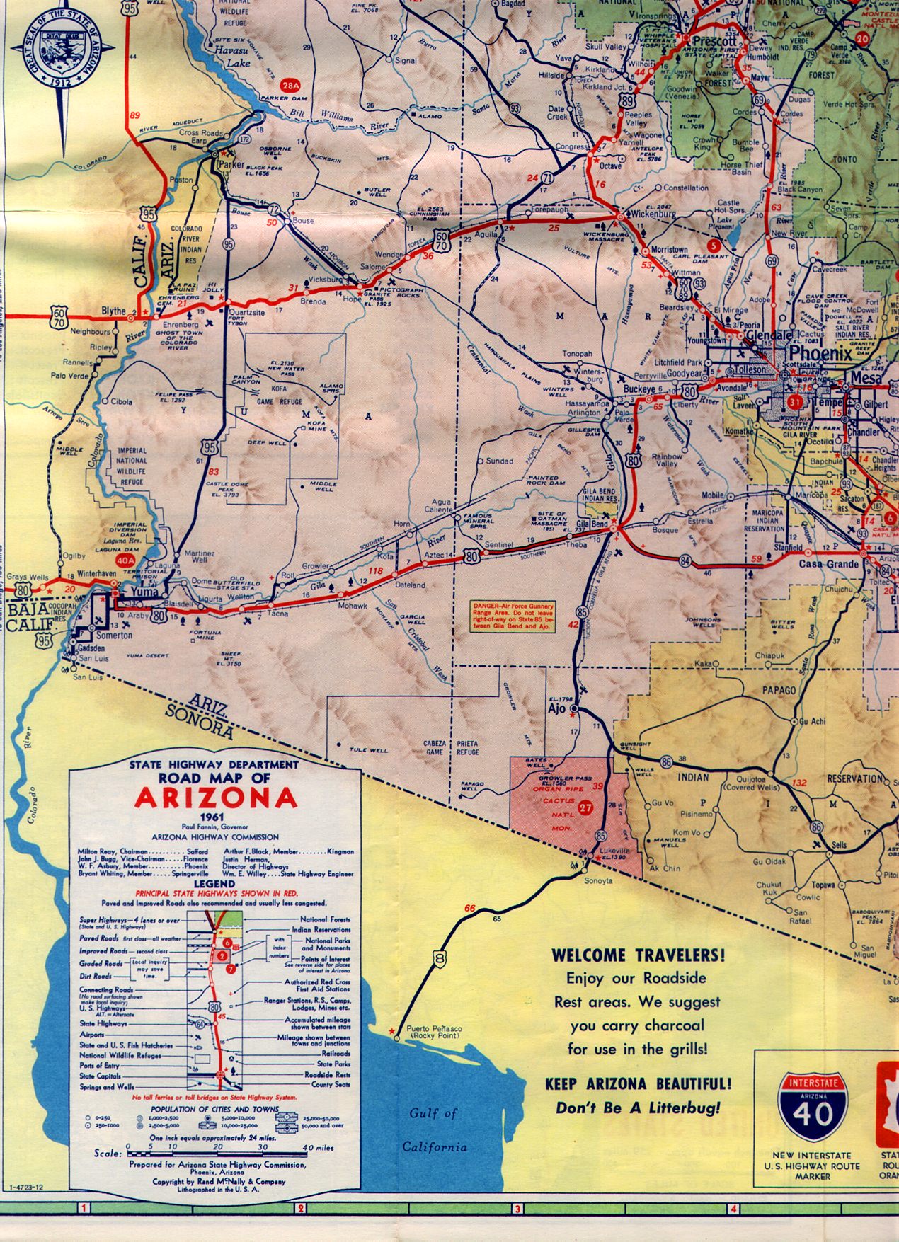
According to USends in 1960 US Route 95 was extended into Arizona via the Blythe Bridge and multiplexed US 60/70 into Quartzsite. The Blythe Bridge was replaced in 1961 by a new structure built for Interstate 10. According to ArizonaRoads AZ 93 was extended south of Wickenburg to Nogales in 1954 and co-signed US 60/70/89 on Grand Avenue to Phoenix. US 60/70/95 can be seen crossing the Colorado River on the 1961 Arizona State Highway Department Map.

During the 1964 California Highway Renumbering US Route 70 was truncated to the Arizona State line. US Route 60 can be seen as a stand alone highway west of Blythe on the 1964 California Division of Highways Map.

At some point between 1967 and 1969 US Route 60 was eliminated from California. US 95 and I-10 can be seen crossing the Colorado River on the 1969 California Division of Highways Map.

According to USends Arizona applied to the AASHTO to have US Route 70 truncated to Globe in 1969 which was approved. US Route 60 officially ended at the Colorado River until 1982 when the AASHTO truncated to it's present terminus at I-10 in Brenda. Both measures can be viewed on official documents which can be viewed on the USends.com links cited above. That said US 60 can be on the 1971 Arizona State Highway Department Map ending in I-10 near Brenda. It is unlikely US 60 was co-signed with I-10 to the Colorado River.

AZ 93 was eliminated at some point between 1984 and 1985 according to ArizonaRoads. The elimination of AZ 93 left US 89 and US 60 co-signed on Grand Avenue between Wickenburg and Phoenix. According to USends US Route 89 was truncated to Flagstaff in 1992 which left only US Route 60 on Grand Avenue between Wickenburg and Phoenix.
Today US Route 60 essentially ends in a lonely strip of the Sonoran Desert at I-10 in the middle of La Paz County.


Chasing down the endpoint of US Route is a good way to end a series but my trip didn't end upon returning to California. Upon my return to California I visited the following locales before heading back home:
- Former US Route 60/70 on Chuckwalla Valley Road and Ragsdale Road.
- Joshua Tree National Park
- California State Route 247
- California State Route 2 over the Angeles Crest Highway
- The Grapevine Grade of Interstate 5
Links to articles pertaining to the topics listed above can be found below:
Old US Route 60/70 through Hell on Chuckwalla Valley Road and Ragsdale Road
Ghost Town Tuesday; Lost Horse Mine and Joshua Tree National Park
Pinto Basin Road and Cottonwood Springs Road; Joshua Tree National Park
California State Route 247; Old Woman Springs Road
California State Route 2 on the Angeles Crest Highway
Legend of the Ridge Route; a history of crossing the mountains between the Los Angeles Basin and San Joaquin Valley from wagon trails to Interstates
Comments