2016 Fall Mountain Trip Part 25; Arizona State Route 69 and Interstate 17 to Phoenix (the history of AZ 69, AZ 79 ii, and I-17)
Upon taking Arizona State Route 89A Spur on Fain Road southeast from mainline AZ 89A I made a left turn south onto AZ 69. My next destination was in Phoenix by way of AZ 69 and I-17. Both AZ 69 and I-17 serve as part of a corridor that made travel through central Arizona massively easier through the progression of the 20th Century.

This article serves as the 25th entry in the 2016 Fall Mountain Trip Series. Part 24 covered the history of AZ 89A/Old US 89A from Flagstaff to Prescott:
2016 Fall Mountain Trip Part 24; Arizona State Route 89A/Old US Route 89A
Prior to the designation of the current AZ 69 the only State maintained highway that took traffic from the Phoenix area to Prescott was US Route 89 (likely US 280 for a short time) over the Bradshaw Mountains via Yarnell Hill and Prescott National Forest. The grades of US 89 on Yarnell Hill were extremely hazardous even by the conventions of the 1920s and the route through Prescott National Forest wasn't much better. Pictured below is Yarnell Hill, the top lanes are the original alignment of US 89.

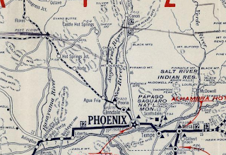
It is odd to consider US 89 was ultimately routed through Yarnell Hill when there was an already established and much shorter route through the Bradshaws between Phoenix-Prescott via Black Canyon. The route north of Phoenix through Black Canyon took travelers through the established mining communities of; Canon (Black Canyon City), Bumble Bee, Cordes, Mayer, Humboldt, and Dewey. In the Auto Trail era this route through Black Canyon was even part of the Evergreen National Highway which can be seen on the 1924 Rand McNally Sectional Highway Map below.


The 1925 Rand McNally Map of Arizona/New Mexico shows the Black Canyon Highway as an Arizona Auto Club Route in addition to being part of the Evergreen National Highway. The Black Canyon Highway was shown to be a dirt surface between Phoenix and Bumblee Bee and gravel surface north to Prescott. Note; the route from Phoenix to Prescott via Yarnell Hill is shown to be entirely gravel by 1925 which probably played a huge factor in why it became US Route 89.


Despite US 89 being routed through Yarnell Hill the route through Black Canyon still remained well maintained. The Black Canyon Highway is shown to be graveled south of Canon on the 1927 Rand McNally Highway Map of Arizona/New Mexico. Note; the 1927 Rand McNally Map displays US Route 280 over Yarnell Hill instead of US 89.

Over the next couple years the Black Canyon Highway was completely graveled all the way to Phoenix as can be seen on the 1931 Clason Highway Map of Arizona/New Mexico.

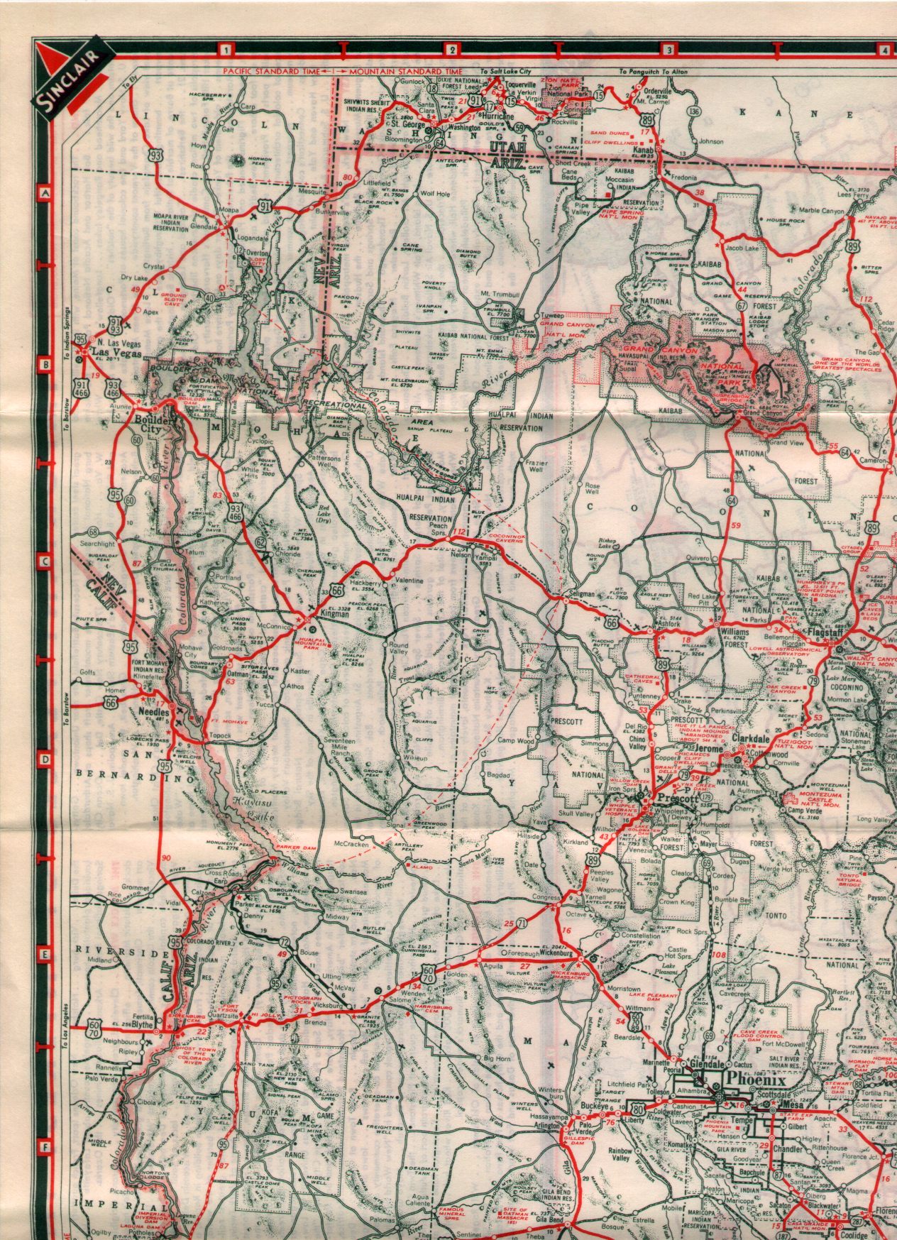
The first AZ 69 was actually commissioned on the new highway from Boulder Dam (Hoover Dam) to Kingman in 1934. This AZ 69 would be replaced quickly by US Route 466 in 1935 but it can be seen on the 1935 Arizona State Highway Department Map.

The current AZ 69 was commissioned in 1936 according to Arizonaroads. The second AZ 69 can be seen on the Black Canyon Highway on the 1938 Rand McNally Highway Map of Arizona.

From Phoenix north to Prescott the original alignment of the current AZ 69 was as follows:
- AZ 69 originated at US 60/70/89 at Grand Avenue at what is now the Glendale/Phoenix City line at 43rd Avenue.
- AZ 69 followed 43rd Avenue north to Yorkshire Drive in Phoenix.
- AZ 69 followed Yorkshire Drive east to 35th Avenue.
- AZ 69 followed 35th Avenue over Skunk Creek into what is now the Skunk Creek Landfill and merged into what is now I-17 near Happy Valley Road.
- AZ 69 followed much of the current route of I-17 north to Black Canyon City. Part of the original route of AZ 69 can be found in New River via North Black Canyon Highway.
- Within Black Canyon City the original route of AZ 69 followed Old Black Canyon Highway.
- North of Black Canyon City AZ 69 originally followed Maggie Mine Road to Crown King Road.
- AZ 69 originally followed Crown King Road through Bumble Bee north to Antelope Creek Road.
- AZ 69 originally followed Antelope Creek Road north through Cordes to Main Street in Mayer.
- In Mayer AZ 69 originally followed Main Street north to Central Avenue.
- From Central Avenue AZ 69 more or less followed the modern highway grade to Old Black Canyon Highway in Humboldt.
- Within Humboldt AZ 69 followed; Main Street, Prescott Street, and Old Black Canyon Highway.
- AZ 69 north of Humboldt followed Old Black Canyon Highway to Dewey.
- From Dewey AZ 69 crossed the modern highway onto a grade that no longer exists to South Dewey Road.
- AZ 69 would have followed a grade through what is now the Prescott Country Club northwest to East Old Black Canyon Highway.
- AZ 69 originally followed East Old Black Canyon Highway back to the modern route.
- AZ 69 originally followed a road through what is now the Lowe's parking lot in Prescott to Old Black Canyon Highway. AZ 69 would have terminated at US 89 via Old Black Canyon Highway which is now located at the intersection of Sun Dog Ranch Road.
According to Arizonaroads.com AZ 69 was slated to become a fully limited access roadway in the Phoenix Area before the Interstate era. The Urban Freeeways page on Arizonaroads.com states that a publication by the Arizona Department of Transportation in 1950 goes into detail regarding the planned upgrades of AZ 69 and the Black Canyon Highway to full limited access.
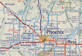
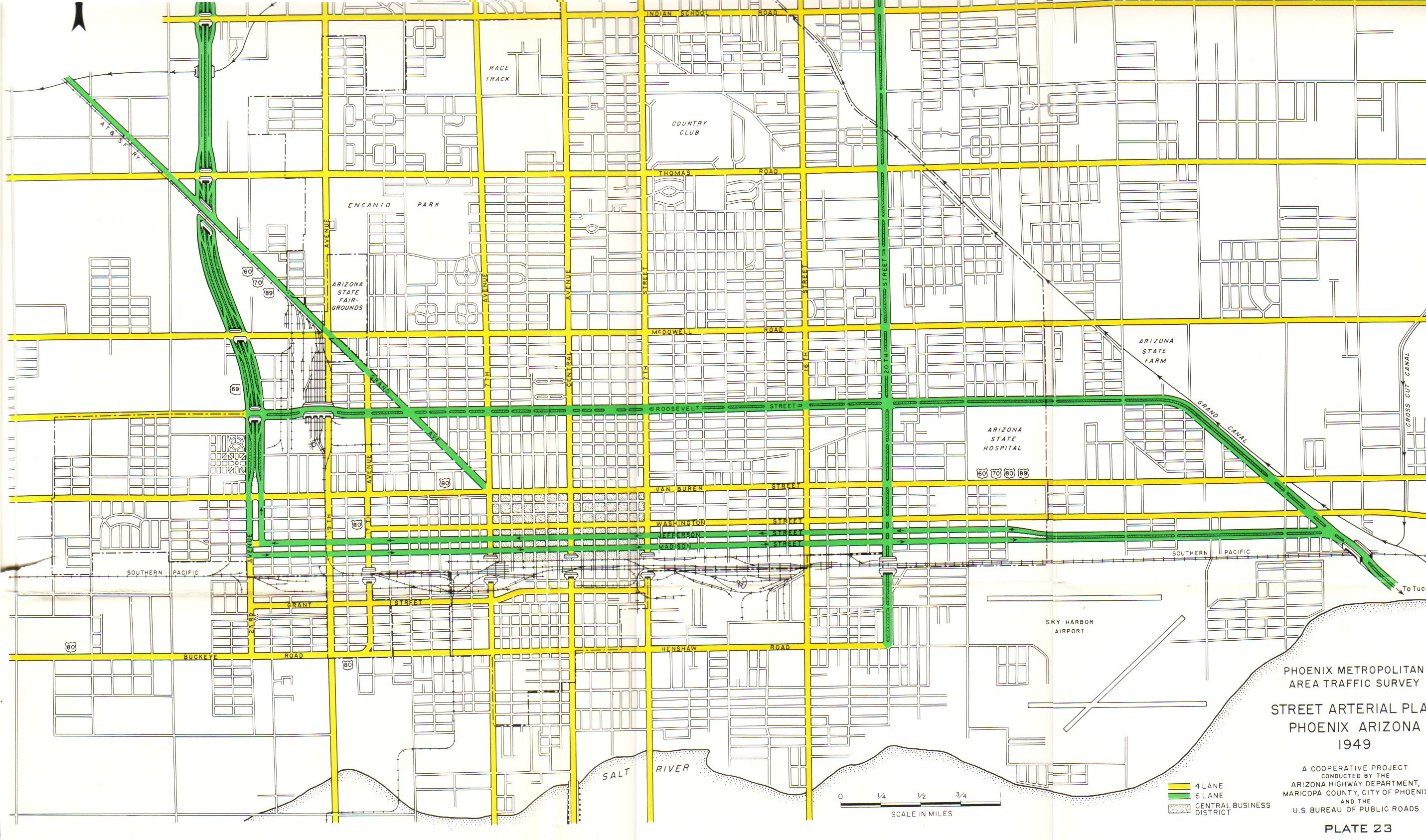
AZ 69 can be seen on the below 1949 planning map as having a limited access terminus at Madison Street in downtown Phoenix. Traffic on AZ 69 southbound would be directed east through downtown Phoenix one-way on Madison Street. Northbound AZ 69 traffic was to be directed one-way west through downtown Phoenix on Jefferson Street. AZ 69 was to have a south terminus at a heavily realigned US 60/US 70/US 89 near Sky Harbor Airport. Presumably AZ 69 would have been multiplexed through downtown Phoenix by US 80.

Beginning in 1950 AZ 69 in the Phoenix Area was realigned from US 60/US 70/US 89 on Grand Avenue north on 27th Avenue to Dunlap Avenue. AZ 69 made a short jog west on Dunlap Avenue where it turned north on 25th Avenue. 25th Avenue and 27th Avenue essentially have become frontage roads of I-17 in modern times. AZ 69 can be seen on the 25th Avenue/27th Avenue alignment on the 1951 Shell Highway Map of Arizona/New Mexico. AZ 69 is also shown to be paved north to the vicinity of Bumble Bee on the Black Canyon Highway.


The construction of AZ 69 to a limited access grade in the Phoenix Area took place through most of the 1950s. AZ 69 is shown to moved partially onto a new freeway grade near Dunlap Avenue on the 1956 Shell Highway Map of Arizona. The same map shows AZ 69 realigned out of Bumble Bee and Cordes onto a new grade that met AZ 79 (ii) in Cordes Junction. The City Insert of Phoenix shows part of AZ 69 completed south of Grand Avenue whereas the highway departs US 60/US 70/US 89/AZ 89 north on 25the Avenue. According Arizonaroads.com (the Black Canyon Highway page) AZ 69 had a temporary alignment south of Grand Avenue on 19th Avenue and Baseline Road.


For reference the second AZ 79 was commissioned in 1954 as a new highway between Cordes Junction and Flagstaff. This new AZ 79 was intended to a be a bypass of US Route 89A through the Jerome area and Sedona. The second AZ 79 is shown complete from Cordes Junction north over the Black Hills to Camp Verde on the 1956 Shell Highway Map. AZ 79 is shown taking a temporary alignment north on AZ 279 to US 89A in Cottonwood. According to Arizonaroads.com the interchange of AZ 69 at Grand Avenue was opened by 1955 and upgraded by 1957

When the Federal Highway Act of 1956 the route of AZ 69 from Phoenix north to Cordes Junction and AZ 79 north to Flagstaff were selected to become part of Interstate 17. I-17 from the get-go was intended to be a major freight route which would connect I-10 in Phoenix to I-40 in Flagstaff. According to Arizonaroads.com the AZ 69 was completed as a freeway north to Dunlap Avenue in November of 1960. AZ 69 can be seen on the 1961 Arizona State Department of Transportation Map as a freeway from US 80/Buckeye Road north to Dunlap Avenue.

AZ 79 is shown completed from Camp Verde to Cordes Junction also on the 1961 Arizona State Department of Transportation Map.

I-10 was aligned off of the Durango Curve in 1969 which became the eastern jog of I-17 in downtown Phoenix. By 1971 AZ 69 between Phoenix and Cordes Junction had been swapped (this apparently occurred in 1968) for I-17 on the 1971 Arizona State Department of Transportation Map. The 1971 map shows I-17 to be completed from I-10 near Sky Harbor Airport close to AZ 279 near Camp Verde. I-17 is also seen with a second completed segment from Camp Verde north to AZ 179. The route from AZ 179 north to Flagstaff is shown carrying the designation of AZ 79 in interim. The remainder of I-17 was completed north to Flagstaff in the Mid-1970s. I-17 can be seen completed on 1976 USGS Maps of Flagstaff.


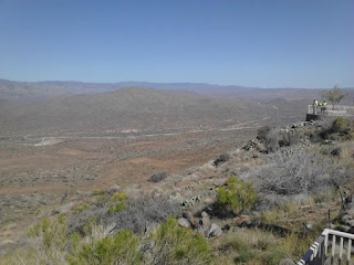
I-17 south of Cordes Junction is the main access point to Agua Fria National Monument via Badger Springs Road at Exit 256. Agua Fria National Monument was declared in 2000 and is easily identified by the infamous "NOT A REST AREA" sign.

South of Badger Springs Road the original alignment of AZ 69 through Black Canyon and Bumble Bee can be seen from the Rest Area at Sunset Point via Exit 252.


Upon descending from Sunset Point I-17 passes through Black Canyon City, New River, and Anthem before entering the northern boundary of the City of Phoenix. In the northern City Limits of Phoenix I-17 intersects AZ 74/Carefree Highway at Exit 223 and AZ Loop 303 at Exit 221.


At Exit 214C I pulled off of I-17 south onto AZ Loop 101 eastbound.

My final turn for the day was onto AZ 51 southbound which I took to my brother's house on Shea Boulevard. The next two days of the trip were spent in the Phoenix Area. I ended up climbing Camelback Mountain and taking a drive out to AZ 88 on the Apache Trail.


As an aside I do have an I-17 shield and AZ 69 shield in my signage collection. My I-17 shield is an extra thick Zumar design which was made to hold up to the strong winds of dust storms.


Part 26 of the 2016 Fall Mountain Trip Series can be found here:
2016 Fall Mountain Trip Part 26; climbing Camelback Mountain

This article serves as the 25th entry in the 2016 Fall Mountain Trip Series. Part 24 covered the history of AZ 89A/Old US 89A from Flagstaff to Prescott:
2016 Fall Mountain Trip Part 24; Arizona State Route 89A/Old US Route 89A
Prior to the designation of the current AZ 69 the only State maintained highway that took traffic from the Phoenix area to Prescott was US Route 89 (likely US 280 for a short time) over the Bradshaw Mountains via Yarnell Hill and Prescott National Forest. The grades of US 89 on Yarnell Hill were extremely hazardous even by the conventions of the 1920s and the route through Prescott National Forest wasn't much better. Pictured below is Yarnell Hill, the top lanes are the original alignment of US 89.
It is odd to consider US 89 was ultimately routed through Yarnell Hill when there was an already established and much shorter route through the Bradshaws between Phoenix-Prescott via Black Canyon. The route north of Phoenix through Black Canyon took travelers through the established mining communities of; Canon (Black Canyon City), Bumble Bee, Cordes, Mayer, Humboldt, and Dewey. In the Auto Trail era this route through Black Canyon was even part of the Evergreen National Highway which can be seen on the 1924 Rand McNally Sectional Highway Map below.


The 1925 Rand McNally Map of Arizona/New Mexico shows the Black Canyon Highway as an Arizona Auto Club Route in addition to being part of the Evergreen National Highway. The Black Canyon Highway was shown to be a dirt surface between Phoenix and Bumblee Bee and gravel surface north to Prescott. Note; the route from Phoenix to Prescott via Yarnell Hill is shown to be entirely gravel by 1925 which probably played a huge factor in why it became US Route 89.


Despite US 89 being routed through Yarnell Hill the route through Black Canyon still remained well maintained. The Black Canyon Highway is shown to be graveled south of Canon on the 1927 Rand McNally Highway Map of Arizona/New Mexico. Note; the 1927 Rand McNally Map displays US Route 280 over Yarnell Hill instead of US 89.

Over the next couple years the Black Canyon Highway was completely graveled all the way to Phoenix as can be seen on the 1931 Clason Highway Map of Arizona/New Mexico.

The first AZ 69 was actually commissioned on the new highway from Boulder Dam (Hoover Dam) to Kingman in 1934. This AZ 69 would be replaced quickly by US Route 466 in 1935 but it can be seen on the 1935 Arizona State Highway Department Map.

The current AZ 69 was commissioned in 1936 according to Arizonaroads. The second AZ 69 can be seen on the Black Canyon Highway on the 1938 Rand McNally Highway Map of Arizona.

From Phoenix north to Prescott the original alignment of the current AZ 69 was as follows:
- AZ 69 originated at US 60/70/89 at Grand Avenue at what is now the Glendale/Phoenix City line at 43rd Avenue.
- AZ 69 followed 43rd Avenue north to Yorkshire Drive in Phoenix.
- AZ 69 followed Yorkshire Drive east to 35th Avenue.
- AZ 69 followed 35th Avenue over Skunk Creek into what is now the Skunk Creek Landfill and merged into what is now I-17 near Happy Valley Road.
- AZ 69 followed much of the current route of I-17 north to Black Canyon City. Part of the original route of AZ 69 can be found in New River via North Black Canyon Highway.
- Within Black Canyon City the original route of AZ 69 followed Old Black Canyon Highway.
- North of Black Canyon City AZ 69 originally followed Maggie Mine Road to Crown King Road.
- AZ 69 originally followed Crown King Road through Bumble Bee north to Antelope Creek Road.
- AZ 69 originally followed Antelope Creek Road north through Cordes to Main Street in Mayer.
- In Mayer AZ 69 originally followed Main Street north to Central Avenue.
- From Central Avenue AZ 69 more or less followed the modern highway grade to Old Black Canyon Highway in Humboldt.
- Within Humboldt AZ 69 followed; Main Street, Prescott Street, and Old Black Canyon Highway.
- AZ 69 north of Humboldt followed Old Black Canyon Highway to Dewey.
- From Dewey AZ 69 crossed the modern highway onto a grade that no longer exists to South Dewey Road.
- AZ 69 would have followed a grade through what is now the Prescott Country Club northwest to East Old Black Canyon Highway.
- AZ 69 originally followed East Old Black Canyon Highway back to the modern route.
- AZ 69 originally followed a road through what is now the Lowe's parking lot in Prescott to Old Black Canyon Highway. AZ 69 would have terminated at US 89 via Old Black Canyon Highway which is now located at the intersection of Sun Dog Ranch Road.
According to Arizonaroads.com AZ 69 was slated to become a fully limited access roadway in the Phoenix Area before the Interstate era. The Urban Freeeways page on Arizonaroads.com states that a publication by the Arizona Department of Transportation in 1950 goes into detail regarding the planned upgrades of AZ 69 and the Black Canyon Highway to full limited access.
AZ 69 can be seen on the below 1949 planning map as having a limited access terminus at Madison Street in downtown Phoenix. Traffic on AZ 69 southbound would be directed east through downtown Phoenix one-way on Madison Street. Northbound AZ 69 traffic was to be directed one-way west through downtown Phoenix on Jefferson Street. AZ 69 was to have a south terminus at a heavily realigned US 60/US 70/US 89 near Sky Harbor Airport. Presumably AZ 69 would have been multiplexed through downtown Phoenix by US 80.

Beginning in 1950 AZ 69 in the Phoenix Area was realigned from US 60/US 70/US 89 on Grand Avenue north on 27th Avenue to Dunlap Avenue. AZ 69 made a short jog west on Dunlap Avenue where it turned north on 25th Avenue. 25th Avenue and 27th Avenue essentially have become frontage roads of I-17 in modern times. AZ 69 can be seen on the 25th Avenue/27th Avenue alignment on the 1951 Shell Highway Map of Arizona/New Mexico. AZ 69 is also shown to be paved north to the vicinity of Bumble Bee on the Black Canyon Highway.


The construction of AZ 69 to a limited access grade in the Phoenix Area took place through most of the 1950s. AZ 69 is shown to moved partially onto a new freeway grade near Dunlap Avenue on the 1956 Shell Highway Map of Arizona. The same map shows AZ 69 realigned out of Bumble Bee and Cordes onto a new grade that met AZ 79 (ii) in Cordes Junction. The City Insert of Phoenix shows part of AZ 69 completed south of Grand Avenue whereas the highway departs US 60/US 70/US 89/AZ 89 north on 25the Avenue. According Arizonaroads.com (the Black Canyon Highway page) AZ 69 had a temporary alignment south of Grand Avenue on 19th Avenue and Baseline Road.


For reference the second AZ 79 was commissioned in 1954 as a new highway between Cordes Junction and Flagstaff. This new AZ 79 was intended to a be a bypass of US Route 89A through the Jerome area and Sedona. The second AZ 79 is shown complete from Cordes Junction north over the Black Hills to Camp Verde on the 1956 Shell Highway Map. AZ 79 is shown taking a temporary alignment north on AZ 279 to US 89A in Cottonwood. According to Arizonaroads.com the interchange of AZ 69 at Grand Avenue was opened by 1955 and upgraded by 1957
When the Federal Highway Act of 1956 the route of AZ 69 from Phoenix north to Cordes Junction and AZ 79 north to Flagstaff were selected to become part of Interstate 17. I-17 from the get-go was intended to be a major freight route which would connect I-10 in Phoenix to I-40 in Flagstaff. According to Arizonaroads.com the AZ 69 was completed as a freeway north to Dunlap Avenue in November of 1960. AZ 69 can be seen on the 1961 Arizona State Department of Transportation Map as a freeway from US 80/Buckeye Road north to Dunlap Avenue.

AZ 79 is shown completed from Camp Verde to Cordes Junction also on the 1961 Arizona State Department of Transportation Map.

I-10 was aligned off of the Durango Curve in 1969 which became the eastern jog of I-17 in downtown Phoenix. By 1971 AZ 69 between Phoenix and Cordes Junction had been swapped (this apparently occurred in 1968) for I-17 on the 1971 Arizona State Department of Transportation Map. The 1971 map shows I-17 to be completed from I-10 near Sky Harbor Airport close to AZ 279 near Camp Verde. I-17 is also seen with a second completed segment from Camp Verde north to AZ 179. The route from AZ 179 north to Flagstaff is shown carrying the designation of AZ 79 in interim. The remainder of I-17 was completed north to Flagstaff in the Mid-1970s. I-17 can be seen completed on 1976 USGS Maps of Flagstaff.


I-17 south of Cordes Junction is the main access point to Agua Fria National Monument via Badger Springs Road at Exit 256. Agua Fria National Monument was declared in 2000 and is easily identified by the infamous "NOT A REST AREA" sign.
South of Badger Springs Road the original alignment of AZ 69 through Black Canyon and Bumble Bee can be seen from the Rest Area at Sunset Point via Exit 252.


Upon descending from Sunset Point I-17 passes through Black Canyon City, New River, and Anthem before entering the northern boundary of the City of Phoenix. In the northern City Limits of Phoenix I-17 intersects AZ 74/Carefree Highway at Exit 223 and AZ Loop 303 at Exit 221.


At Exit 214C I pulled off of I-17 south onto AZ Loop 101 eastbound.

My final turn for the day was onto AZ 51 southbound which I took to my brother's house on Shea Boulevard. The next two days of the trip were spent in the Phoenix Area. I ended up climbing Camelback Mountain and taking a drive out to AZ 88 on the Apache Trail.


As an aside I do have an I-17 shield and AZ 69 shield in my signage collection. My I-17 shield is an extra thick Zumar design which was made to hold up to the strong winds of dust storms.


Part 26 of the 2016 Fall Mountain Trip Series can be found here:
2016 Fall Mountain Trip Part 26; climbing Camelback Mountain
Comments