
1882 Fowler Rail Depot

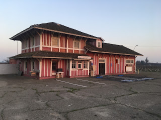
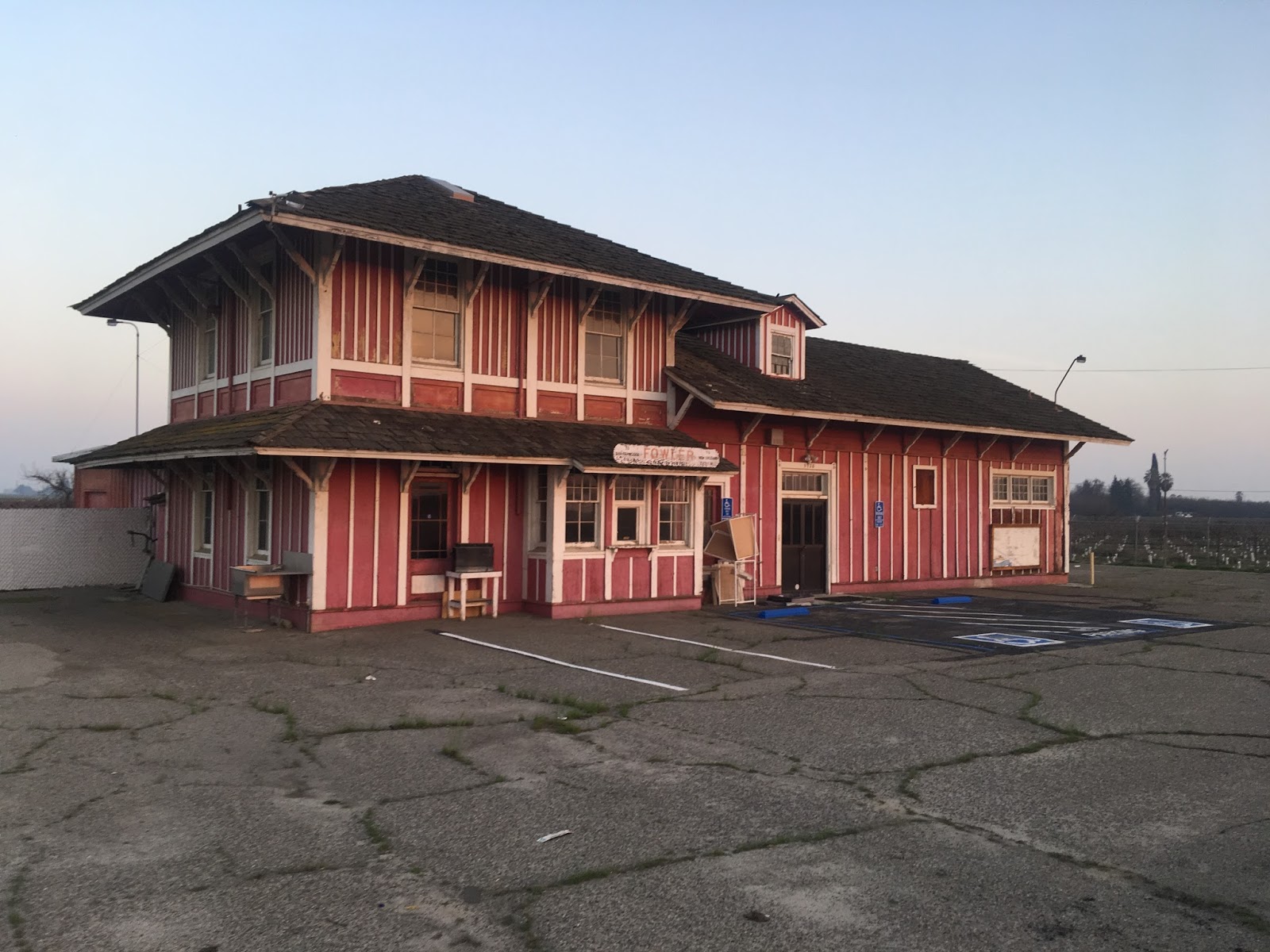
Over the last month or so I've been driving by a mysterious red building at Clovis Avenue and Lincoln Avenue near California State Route 99 in Fresno County.  The building greatly resembled a rail depot and I noticed it displayed the name of the City of Fowler.  It turns out that the building is the 1882 Fowler Rail Depot which was moved northwest out of downtown Fowler to it's present location.  The Fowler Rail Depot appears to have once been a business as it has a large security fence is surrounding it and there is handicap parking zones.  The sign on the Depot shows San Francisco 216 miles to the west and New Orleans 2,271 miles to the east.


Rail service dates back to 1872 when the Central Pacific Line through San Joaquin Valley was completed.  At the time the Central Pacific line was completed there was a rail switch also built to the ranches of State Senator Thomas Fowler known as Fowler's Switch.  There is a small monument about Fowler's Switch located at 7th Street and Merced Street.


The Fowler Rail Siding was constructed also in 1882 along with a Post Office.  The map below shows the 1882 Fowler Rail Depot located at Main Street and 7th Street. 

1892 Map of the City of Fowler

Presently there is nothing but a vacant lot at Main Street and 7th Street in downtown Fowler where the 1882 Fowler Rail Depot once stood.


Comments

Kevin said…
I've got an 8mm movie film, recently digitized, showing this depot moving to the new spot in Fowler. I'll share the link soon.

Popular posts from this blog

Did Caltrans just kill the G26 cutout US Route shields?

The US Route System was formally created by the American Association of State Highway Officials during November 1926.  Through the history of the system the only state to which has elected to maintain cutout US Route shields has been California.  The G26 series cutout US Route shields have become a favorite in the road enthusiast hobby and are generally considered to be much more visually pleasing than the standard Federal Highway Administration variant.  However, the G26 shield series appears to have been killed off on January 18, 2026, when Caltrans updated their Manual of Uniform Traffic Control Devices.  This blog will examine the history of the US Route shield specifications in California and what is happening with the 2026 changes.  The blog cover photo is facing towards the terminus of California State Route 136 and at a G26-2 specification US Route 395 shield.  In the background Mount Whitney can be seen in the Sierra Nevada range.   ...

Three Points Road (Los Angeles County)

Three Points Road is a rural cutoff route which connects Pine Canyon Road (Los Angeles County Route N2) and California State Route 138 near Neenach of Antelope Valley.  Originally the community of Three Points (named for the junction Pine Canyon, Oakdale Canyon and Oakgrove Canyon) was served by 265th Avenue West.  The modern three-mile-long corridor of Three Points Road was developed by 1950 to serve as a softer transition to California State Route 138.  Part 1; the history of Three Points Road Three Points Road is named in reference to the community near the extinct Neenach Volcano known as Three Points.  Three Points itself is a reference to three canyons it sits in the middle of: Pine Canyon, Oakgrove Canyon and Oakdale Canyon.  Three Points was homesteaded by the Laffery family in 1892.  Nearby Gookins Lake was named after one of the Laffery family members.   Three Points (blue pin) can be seen at the intersection of Pine Canyon Road (now Los...

Hawaii Route 50

Hawaii Route 50 is the longest Sign Route on the island of Kauai at 32.6 miles.  The entirety of Hawaii Route 50 is overlaid atop Kaumualii Highway from Lihue west to the Pacific Missile Range Facility at Barking Sands. Hawaii Route 50 is one of the original 1955-era State Highway designations on Kauai.  Much of the Kaumualii Highway corridor was constructed during the sugar plantation boom of the late Hawaiian Kingdom.  The first tee beam bridge in Hawaii would be constructed along the Kaumualii Highway in 1911 at the Hanapepe.  Much of this highway would be modernized to two-lane standards through the 1930s and 1940s. This page is part of the Gribblenation Hawaii Roads series.  A compellation of all Hawaii-related media from both Gribblenation and RoadwayWiz can be found by clicking  here .  Part 1; the history of Hawaii Route 50 and Kaumualii Highway Hawaii Route 50 is the longest highway on Kauai at 32.6 miles.  The highway begins at Rice Str...