As originally defined US Route 99 terminated at US Route 80 in El Centro of Imperial County, California. US Route 99 was extended to the Mexican Border in Calexico by way of what was supposed to be temporary alignment through Heber during June of 1932. US Route 99 would remain aligned to the Mexican Border in Calexico until being truncated to Los Angeles during June 1963. Above US Route 99 can be seen terminating at the Mexican Border at the end of Heffernan Avenue in 1933. Below US Route 99 can be seen following 4th Street south of US Route 80/Main Street in El Centro, Corfman Road, Heber Road through Heber, Imperial Avenue into downtown Calexico, 3rd Street and Heffernan Avenue in Calexico to the Mexican Border on the
1935 Division of Highways Map of Imperial County.
This blog is part of the larger Gribblenation US Route 99 Page. For more information pertaining to the other various segments of US Route 99 and it's three-digit child routes check out the link the below.
The history of US Route 99 in Heber and Calexico
Both Heber and Calexico were developed by the Imperial Land Company. The Imperial Land Company incorporated during March of 1900 with the purpose of encouraging settlement of Imperial Valley. The Imperial Land Company would also go on to have a hand in founding Brawley, Imperial and even Mexicali on the Baja California side of Imperial Valley. By June 1904 a line of the
Southern Pacific Railroad to Calexico was completed which helped bring Imperial Valley to prominence. Imperial County took it's name from the Imperial Land Company and would split from San Diego County August 7th, 1907. Calexico incorporated as a City on April 16th, 1908.
The emergence of the automobile in the early 20th Century led to the 1909 First State Highway Bond Act which was approved by voters during 1910. The majority of the highways approved as part of the First State Highway Bond Act were largely well established routes of travel. In the case of southern Imperial Valley the only major highway it received as part of the 1909 First State Highway Bond Act was
Legislative Route Number 12 ("LRN 12") which was plotted from San Diego to El Centro.
The Second State Highway Bond Act was issued during 1916.
LRN 26 and LRN 27 were added to the State Highway System through Imperial Valley with the following description:
"an extension of the San Bernardino county state highway lateral to the Arizona State Line near the town of Yuma, Arizona, via the cities of Brawley and El Centro in Imperial County by the most direct and practical route..."
In the case of LRN 26 it's eastern terminus was located in El Centro whereas LRN 27 continued east to the Arizona State Line and Yuma. The extension of LRN 26 and the new LRN 27 can be seen in Imperial Valley for the first on the
1918 California Highway Commission Map. Notably the nearest State Highway access to Heber and Calexico was located to the north in El Centro.


The US Route System was finalized on November 11th, 1926 by the Executive Committee of the American Association of State Highway Officials ("AASHO"). US Route 99 ("US 99") was one of the original US Routes created by the AASHO Executive Committee. As originally plotted US 99 followed LRN 26 to it's southern terminus at US 80 in El Centro. The original southern terminus of US 99 in El Centro can be seen in the AASHO US Route descriptions for California dated November 11th, 1926. The original southern terminus of US 99 in El Centro was located on Imperial Avenue at US 80/Adams Avenue


1931 Legislative Chapter 82 extended LRN 26 to Colton and to the Mexican Border in Calexico. On September 8th, 1931 the California Division of Highways proposed an extension of US 99 from US 80 in El Centro south to the Mexican Border at Calexico. In the proposal letter by State Highway Engineer to the AASHO it is noted that the road through Heber and Calexico to the Mexican Border had been taken over as part of LRN 26 on August 14th, 1931. A temporary alignment of US 99/LRN 26 is stated to follow 4th Street south of US 80/Main Street in El Centro, Corfman Road, Heber Road through Heber, Imperial Avenue into downtown Calexico, 3rd Street and Heffernan Avenue in Calexico to the Mexican Border. The letter by the State Highway Engineer states a streamlined connecting highway north from Calexico to US 80/LRN 27 east of El Centro was planned as the future alignment of US 99/LRN 26.


The
August 1931 California Highways & Public Works announced 722 miles had been added to the State Highway System effective August 14th, 1931. The 10.05 mile extension of LRN 26 from El Centro to the Mexican Border in Calexico is noted in the mileage table and as item (p).
The AASHO Executive Committee on June 22nd, 1932 notified the California Division of Highways that US 99 was approved to be extended to the Mexican Border via the extension of LRN 26.
Below the southern terminus of US 99 on Heffernan Avenue at the Mexican Border in Calexico can be seen on a 1933 postcard.
1933 Legislative Chapter 767 added LRN 201 to the State Highway System with the following defintion:
"From a point on LRN 26 approximately 2 mi W of Brawley to a point on said LRN 26 approximately 2 1/2 mi SW of Brawley" and "Calipatria to Brawley-Holtville Road.
LRN 201 first appears on the 1934 Division of Highways Map with the more simplistic definition of "Route 187 near Calipatria to Route 26 east of Heber." Despite LRN 201 being adopted over the planned streamlined route of US 99 north of Calexico to US 80/LRN 27 it never became part of the highway.
CA 111 is shown to be extended south from Brawley to US 99/LRN 26 near Heber via LRN 201 on the
1937-38 Division of Highways Map. The corridor of CA 111/LRN 201 from US 80/LRN 27 south to US 99/LRN 26 near Heber as noted above was intended originally to be part of US 99.
Below the southern terminus of US 99 on Heffernan Avenue at the Mexican Border in Calexico can be seen in this undated
photo from the 1950s.
A detailed scan of the 1958 USGS Map of Calexico on historicaerials.com shows the alignment of US 99 following Imperial Avenue, 3rd Street and Heffernan Avenue to the Mexican Border.
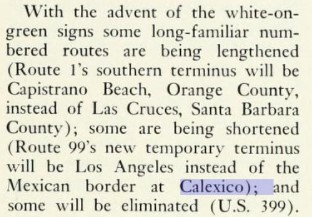
The truncation of US 99 from Calexico to the junction of the Golden State Freeway and San Bernardino Freeway in Los Angeles was approved by the AASHO Executive Committee on June 19th, 1963. The justification by the California Division of Highways to truncate US 99 was to avoid what the agency viewed as confusing multiplexes on the new Interstate corridors of Southern California.


The truncation of US 99 was part of the wider 1964 California State Highway Renumbering. The 1964 California State Highway Renumbering eliminated Legislative Route Numbers in favor of field signage, minimized multiplexes, eliminated US Routes which didn't cross the State Line and assigned field signage to former Legislative Route Numbers which lacked it. Former US 99 in the Indio-Heber Corridor is shown on the 1964 Division of Highways Map to be assigned to CA 86 whereas the Heber-Calexico segment was assigned to an extended CA 111.
The AASHO Renumbering database shows that US 99 was approved to be truncated out of California to Ashland, Oregon by the AASHO Executive Committee on June 29th, 1965. This measure would have become effective on New Years Day 1966.
1993 California Senate Resolution 19, Chapter 73 named CA 111 Postmiles IMP 0.000-IMP R21.993 as "Historic US Highway 99." Functionally this designation does not make sense given CA 111 north of Heber Road (Postmile IMP R4.73) was never part of US 99.
During
1995 a new border station in Calexico was opened west of the 1939 station at Heffernan Avenue. CA 111 was shifted off of the former alignment of US 99 on 3rd Street onto to the new border station southbound via Imperial Avenue and westbound 2nd Street. Northbound CA 111 now begins at the 1995 border station which flows directly into Imperial Avenue. This can be seen reflected in the "R" suffix in the Caltrans Postmile Tool which indicates the highway was realigned a single time after the 1964 State Highway Renumbering.
The 1995 border station realignment CA 111 appears to have coincided with 3rd Street no longer being accessible from Imperial Avenue. This action made it functionally impossible to replicate southbound US 99 continuously in Calexico by car. Below the barrier obstructing access from southbound CA 111/Imperial Avenue to eastern 3rd Street can be seen.
Noting the above obstruction this makes the historic signage installed 2nd Street east of Imperial Avenue inaccurate for two reasons; it wasn't the actual end point of US 99 nor was 2nd Street ever part of US 99. Notably the US 99 Begin signage on Heffernan Avenue is accurately placed (photo courtesy of M3100).
Further Reading on US Route 99
Continuing north of US Route 99 to El Centro?


Comments