
Downers Covered Bridge (Upper Falls Covered Bridge) - Vermont


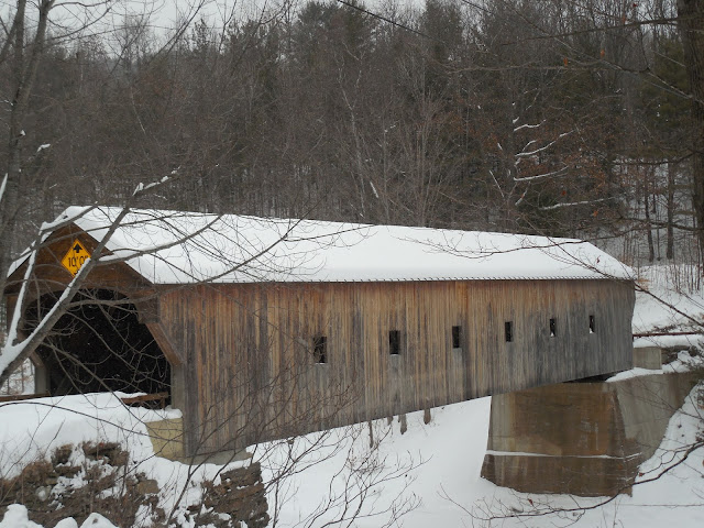
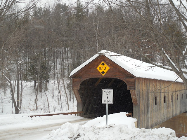
Also known as the Upper Falls Covered Bridge, the Downers Covered Bridge spans 129 feet across the Black River in Weathersfield, Vermont. The bridge was named for Abraham Downer, who was an early settler of Weathersfield. Downer and his descendants gave the name to the area where VT 106 and VT 131 now meet, known as Downer's Four Corners or Downers. Being in the general area, the bridge had become known as the Downers Covered Bridge.

The Downers Covered Bridge was built in 1840 by James Tasker, who was also the builder of the Salmond and Titcomb (Stoughton) Covered Bridges located nearby. Tasker designed the Downers Covered Bridge with a covered Town Lattice through truss design, plus the portals were intricately constructed to simulate a Greek Revival architecture, which was popular at the time (but not necessarily with covered bridges).

The covered bridge was extensively restored in 1975 and 1976 by famed covered bridge builders Milton Graton and Associates of Ashland, New Hampshire. Graton's team rebuilt the trusses, raised the bridge by 2.5 feet so that water could not flow in and damage the timbers, and reframed the floor with heavier timbers so the bridge would be more durable for modern traffic. In raising the bridge, that may be why you see one stone abutment and one concrete abutment for the bridge. Then in 2007, additional renovations by Wright Construction of Mount Holly, Vermont took place for items that were not addressed during the earlier restoration. This restoration included replacing parts of the bottom lower chord and adding a fifth chord to help strengthen the bridge span.


How to Get There:


Sources and Links:
Vermont Covered Bridge Society - Upper Falls Covered Bridge
Bridgehunter.com - Downers Covered Bridge 45-14-08
Covered Bridges on Two Wheels - Upper Falls Bridge

Comments

Popular posts from this blog

Abandoned Fowler Avenue in Clovis, California

Originally Fowler Avenue in the city of Clovis had a brief discontinuation approaching Herndon Avenue.  Fowler Avenue traffic heading northbound was required to detour briefly onto westbound Herndon Avenue.  During 2001 this discontinuation was removed when Fowler Avenue was reconfigured to access the Sierra Freeway (California State Route 168) via an interchange.  This led to a segment of the original alignment of Fowler Avenue just south of Herndon Avenue to be abandoned.  Despite a shopping center opening over part of the original Fowler Avenue alignment in 2016 much of the abandoned roadway remains.   The history of the abandoned original alignment of Fowler Avenue in Clovis The original alignment of California State Route 168 departed downtown Clovis eastbound along Tollhouse Road.  This original alignment did not interact with Fowler Avenue at the Herndon Avenue intersection.  Fowler Avenue north of Tollhouse Road ran north to Herndon Avenue...

May 2023 Ontario Trip (Part 3 of 3)

  Over the years, I have made plenty of trips to Ontario, crisscrossing the southern, central and eastern parts of the province. Living in Upstate New York, it's pretty easy to visit our neighbor to the north, or is that our neighbor to the west? Ottawa is one of my favorite cities to visit anywhere in the world, plus I've discovered the charm of Kingston, the waterfalls of Hamilton (which is on the same Niagara Escarpment that brings us Niagara Falls), the sheer beauty of the Bruce Peninsula, and more. But I hadn't explored much of Cottage Country. So I decided to change that, and what better time to go than over Memorial Day weekend, when the daylight is long and I have an extra day to explore. On the third and final day of my trip, I started in Huntsville and made my way through Muskoka District and Haliburton County, passing by many lakes along the way. I stopped in towns such as Dorset, Haliburton and Bancroft before making a beeline down to Belleville and then over th...

What's In a Name?: When the Roads Really Do Tell a Story

  Our tagline on the Gribblenation blog is "because every road tells a story". Some roads tell different stories than others. Along our travels, we may see historic markers that tell us a little story about the roads we travel or the places we pass by. Some historic markers are more general, as to telling us who lived where or what old trail traversed between two towns. During my travels across New York State and other states or provinces, I pass by many historic markers, some with interesting or amusing references to roads. I wanted to highlight a few of the markers I've seen along my travels around the Empire State and help tell their stories. Those stories may be as specific as explaining the tales of a tree that was used to help measure a distance of eight miles from Bath to Avoca in Steuben County, as referenced on the Eight Mile Tree historical marker above. They may also help point the way along historical roads first used centuries ago, or may help tell a local l...