
Kalākaua Avenue, Honolulu

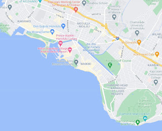
Kalākaua Avenue ("Kalakaua Avenue") is a major city street in the City of Honolulu on the Hawaiian island of O'ahu.  Kalakaua Avenue originates in the neighborhood of Makiki near Interstate H-1.  Kalakaua Avenue follows a generally eastward course through McCully-Moiliili over the Ala Wai Canel into Waikiki.  Kalakaua Avenue through Waikiki is generally a one-way through road which terminates near Diamond Head Crater.

This page is part of the Gribblenation O'ahu Highways page.  All Gribblenation and Roadwaywiz media related to the highway system of O'ahu can be found at the link below:

https://www.gribblenation.org/p/gribblenation-oahu-highways-page.html


Part 1; a brief history of Kalākaua Avenue 

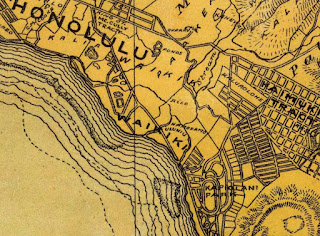
What is now Kalakaua Avenue has been the main point of entry into Waikiki since the 19th Century when it was known as Waikiki Road.  Stage service opened for service on Waikiki Road during 1868 which was replaced by a horse driven tramcar system in 1888.  Below Waikiki Road can be seen on the 1881 C.J. Lyons Map of O'ahu.

Waikiki Road can be seen as the main highway through Waikiki on the 1899 J.T. Taylor Map of O'ahu.


During 1901 electric trolley service opened on Waikii Road.  Waikiki Road was renamed during 1908 to Kalakaua Avenue in honor of the last King of Hawaii Kalākaua.  Kalakaua Avenue modernized significantly upon the completion of the Ala Wai Canal in 1928.  The Ala Wai Canal shunted stream run off into Waikiki which allowed it to transform from a wet land into the tourism district of Honolulu.  

During World War II the territory of Hawaii saw an influx of military activity following the attack on Pearl Harbor on December 7th, 1941.  Numerous Military Routes and early Hawaii Routes were signed through the Hawaiian Territory to aid military personnel in navigating the islands.  Military Highways were assigned US Route style shields whereas lesser highways were assigned an early variation of what is now the Hawaii Route Spade.  A 1946 Army Map of the Island of O'ahu Kalakaua Avenue in Waikiki was assigned as part of Hawaii Route 101.  Kalakaua Avenue was an important military connector due to the presence of Fort DeRussy in Waikiki and Fort Ruger at Diamond Head Crater.  


Circa 1955 following the conclusion of World War II the United States Bureau of Public Roads renumbered the Hawaii Route System.  The 1955 Hawaii Route renumbering saw most of the conventions utilized by the current Hawaii State Route System established.  Primary Hawaii Routes were given two digit numbers whereas Secondary Hawaii Routes were given three digit numbers.  The Hawaii Routes were assigned in sequence for what Island/County they were located on coupled with what Federal Aid Program number they were tied to.  In the case of O'ahu the Island was assigned numbers in the range of 60-99.  Kalakaua Avenue was not retained as a Hawaii Route and did not receive a new designation.  Kalakaua Avenue can be seen on the 1959 Shell Highway Map of Hawaii without a Hawaii Route designation.  


Part 2; exploring Kalākaua Avenue 

From Interstate H-1 traffic is directed to use Exit 23 onto Punahoa Street to reach Waikiki.


From Punahoa Street southbound traffic can access Kalakaua Avenue by turning west onto Beretania Street.  From westbound Beretania Street traffic can access Kalakaua Avenue southbound.  


Kalakaua Avenue southbound passes through Makiki and McCully-Moiliili to the Ala Wai Canal into Waikiki.  


Within Waikiki southbound Kalakaua Avenue becomes a one-way street and intersects Hawaii Route 92 at Ala Moana Boulevard at Fort DeRussy.  


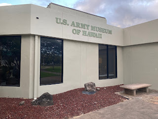
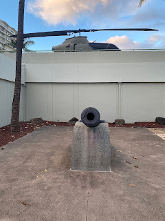
The Fort DeRussy Military Reservation in Waikiki is under the jurisdiction of the U.S. Army but functions more as a park during modern times.  Fort DeRussy was originally constructed during 1911 along with Battery Randolph.  Battery Randolph now houses the U.S. Army Museum of Hawaii.


From Fort DeRussy Beach one can see how much Diamond Head Crater towers of Waikiki.  


Kalakaua Avenue has several all-way pedestrian crossings such as the one below at Lewers Street.


Featured below is a Blue Stop Sign seen at Lauula Street and Lewers Street just east of Kalakaua Avenue. Blue Stop Signs are typically seen in Hawaii on private drives given the State prohibits official looking signage.


Kalakaua Avenue southbound at Royal Hawaiian Center Avenue.


Part 3; Roadwaywiz
Kalākaua Avenue

During June of 2019 Dan Murphy of the Roadwaywiz Youtube Channel (and Gribblenation) featured real-time drives on Kalakaua Avenue. Below Kalakaua Avenue can be viewed headed eastbound during the daytime.


Below Kalakaua Avenue can be viewed headed eastbound during the nighttime.


Comments

Popular posts from this blog

North Carolina Continues to Move Forward with Rail

2023 and the first half of 2024 have seen continued growth in North Carolina's passenger rail system.  From increased daily trains from Raleigh to Charlotte, federal funds for studying additional corridors, and receiving a historic grant to begin the construction of high-speed rail between Raleigh and Richmond, the last 18 months have been a flurry of activity at NCDOT's Rail Division.  And that's just the tip of the iceberg. As ridership and routes increase - the engine of North Carolina passenger rail trains will become a more common sight. (Adam Prince) Increased Passenger Train Service: On July 10, 2023, a fourth Piedmont round-trip rail service between Raleigh and Charlotte commenced.  The four Piedmont trains plus the daily Carolinian (to Washington, DC, and New York) bring the total of trains serving the two cities daily to five. The current daily Piedmont and Carolinian schedule between Charlotte and Raleigh (NCDOT) The result was over 641,000 passengers utilized pa

US Route 101 in Benbow, Garberville and Redway

The communities of Benbow, Garberville and Redway can all be found along US Route 101 within southern Humboldt County.  The former surface alignment of US Route 101 in Garberville and Redway once crossed the Garberville Bluffs along what is now Redwood Drive via a corridor constructed as part of the Redwood Highway during the 1910s.  US Route 101 through Benbow, Garberville and Redway was modernized by 1935.  US Route 101 would eventually be upgraded to freeway standards in Benbow, Garberville and Redway by extension of the Redwood Freeway during 1966-68.  As the cover photo the original grade of US Route 101 and the Redwood Highway can be seen at the Garberville Bluffs during 1934.  US Route 101 can be seen in the communities of Benbow, Garberville and Redway on the 1935 Division of Highways Map of Humboldt County .   The history of US Route 101 in Benbow, Garberville and Redway Benbow, Garberville and Redway lie on the banks of the South Fork Eel River of southern Humboldt County.  D

The Midway Palm and Pine of US Route 99

Along modern day California State Route 99 south of Avenue 11 just outside the City limits of Madera one can find the Midway Palm and Pine in the center median of the freeway.  The Midway Palm and Pine denotes the halfway point between the Mexican Border and Oregon State Line on what was US Route 99.  The Midway Palm is intended to represent Southern California whereas the Midway Pine is intended to represent Northern California.  Pictured above the Midway Palm and Pine can be seen from the northbound lanes of the California State Route 99 Freeway.   This blog is part of the larger Gribblenation US Route 99 Page.  For more information pertaining to the other various segments of US Route 99 and it's three-digit child routes check out the link the below. Gribblenation US Route 99 Page The history of the Midway Palm and Pine The true timeframe for when the Midway Palm and Pine (originally a Deadora Cedar Tree) were planted is unknown.  In fact, the origin of the Midway Palm and Pine w