Following reaching the western terminus of US Route 163 in Kayenta I turned west on US Route 160 towards US 89 and the Grand Canyon.

This blog serves as Part 20 of the 2016 Fall Mountain Trip Series, Part 19 can be found here:
2016 Fall Mountain Trip Part 19; US Route 163 through Monument Valley
US 160 through Arizona is entirely contained within the Navajo Nation from the New Mexico State line westward to US 89 near Tuba City. The current designation of US 160 was extended into Arizona in 1970.
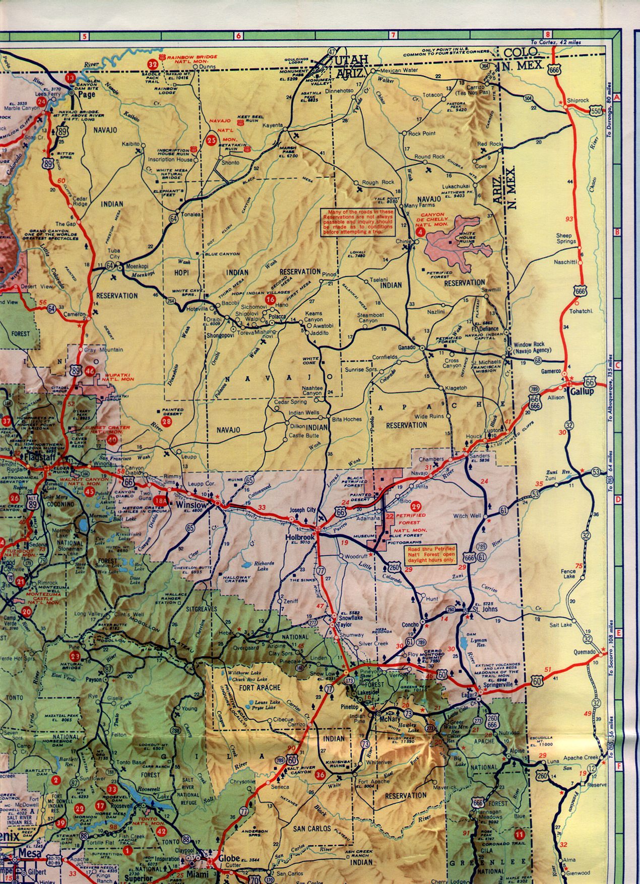
The original designations on the current corridor of US 160 in Arizona was AZ 364 from the New Mexico State Line west to Teec Nos Pos and AZ 64 all the way to US 89. The designation of AZ 64 was extended east of Cameron in 1961 to the New Mexico State Line via the current corridor of US 160 and US 64. AZ 64 can be seen built all the way east to the Navajo County line on this 1961 Arizona Highway sectional map.
1961 Arizona Highway Sectional Map
In 1966 the current route of US 160 from the New Mexico State Line to US 89 was changed to US 164. US 164 from Arizona extended eastward to a terminus at Cortez, Colorado. Within Arizona the route of US 164 apparently multiplexed US 89 all the way to Flagstaff. Some of the US 164 field signage can be seen on USends.com.
USends on US 164
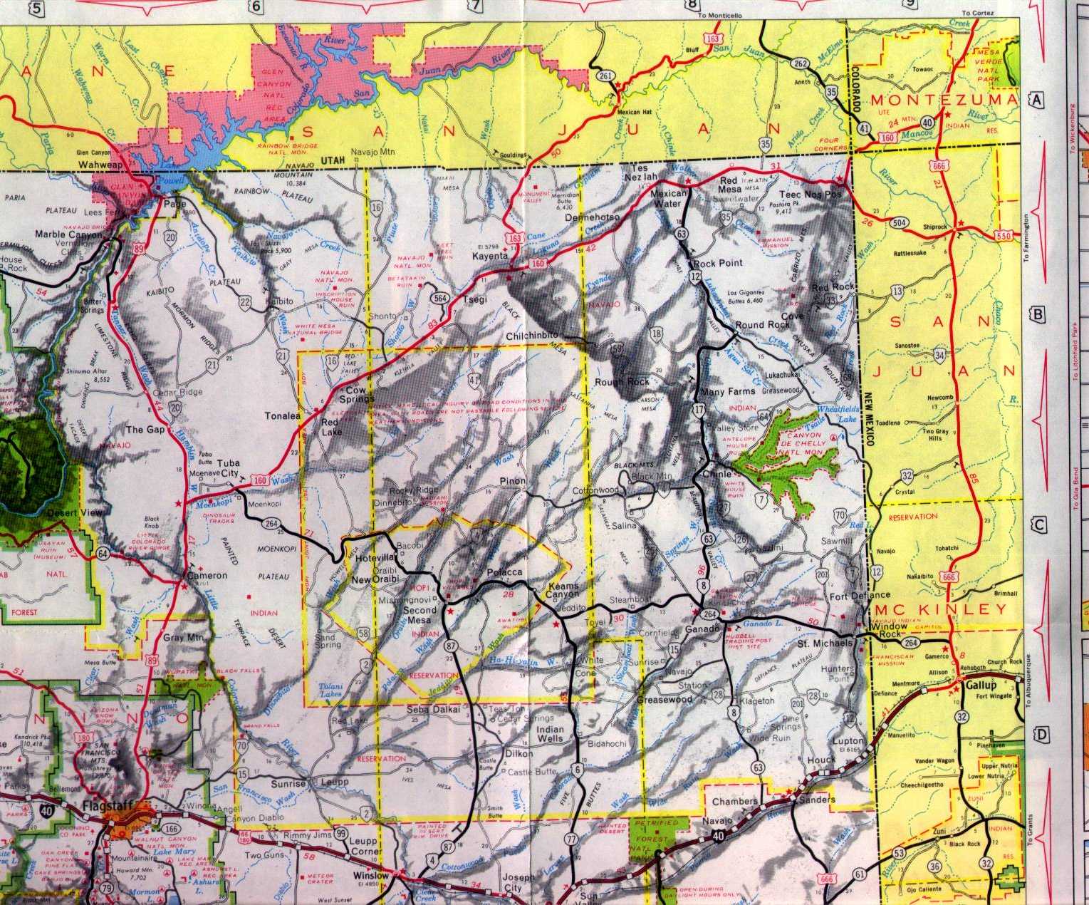
In 1970 US 160 was rerouted from Crescent Junction, Utah onto it's current route in Arizona. The change to US 160 can be seen on this 1971 Arizona Highway sectional map.
1971 Arizona Highway Sectional Map
As shown in the blog cover photo I made a right hand turn from US 163 onto US 160 westbound in Kayenta of Navajo County. West of Tsegi US 160 meets a significant junction with AZ 564 which is an artifact of AZ 64.

AZ 564 provides access to Navajo National Monument and was covered on a previous blog.
Arizona State Route 564 and Navajo National Monument
Near the Coconino County Line US 160 west intersects AZ 98.

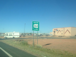
In Tuba City US 160 west intersects AZ 264. AZ 264 is the longest child route of AZ 64 and extends east through the Hopi Nation and Navajo Nation to NM 264.
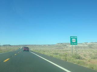
West of Tuba City US 160 terminates at US 89. I turned southward on US 89 to reach AZ 64 to access Grand Canyon National Park.

Part 21 of the 2016 Fall Mountain Trip series covers former US Route 89 over the 1911 Cameron Suspension Bridge.
2016 Fall Mountain Trip Part 21; former US Route 89 on the Cameron Suspension Bridge

This blog serves as Part 20 of the 2016 Fall Mountain Trip Series, Part 19 can be found here:
2016 Fall Mountain Trip Part 19; US Route 163 through Monument Valley
US 160 through Arizona is entirely contained within the Navajo Nation from the New Mexico State line westward to US 89 near Tuba City. The current designation of US 160 was extended into Arizona in 1970.
The original designations on the current corridor of US 160 in Arizona was AZ 364 from the New Mexico State Line west to Teec Nos Pos and AZ 64 all the way to US 89. The designation of AZ 64 was extended east of Cameron in 1961 to the New Mexico State Line via the current corridor of US 160 and US 64. AZ 64 can be seen built all the way east to the Navajo County line on this 1961 Arizona Highway sectional map.
1961 Arizona Highway Sectional Map
In 1966 the current route of US 160 from the New Mexico State Line to US 89 was changed to US 164. US 164 from Arizona extended eastward to a terminus at Cortez, Colorado. Within Arizona the route of US 164 apparently multiplexed US 89 all the way to Flagstaff. Some of the US 164 field signage can be seen on USends.com.
USends on US 164
In 1970 US 160 was rerouted from Crescent Junction, Utah onto it's current route in Arizona. The change to US 160 can be seen on this 1971 Arizona Highway sectional map.
1971 Arizona Highway Sectional Map
As shown in the blog cover photo I made a right hand turn from US 163 onto US 160 westbound in Kayenta of Navajo County. West of Tsegi US 160 meets a significant junction with AZ 564 which is an artifact of AZ 64.

AZ 564 provides access to Navajo National Monument and was covered on a previous blog.
Arizona State Route 564 and Navajo National Monument
Near the Coconino County Line US 160 west intersects AZ 98.

In Tuba City US 160 west intersects AZ 264. AZ 264 is the longest child route of AZ 64 and extends east through the Hopi Nation and Navajo Nation to NM 264.

West of Tuba City US 160 terminates at US 89. I turned southward on US 89 to reach AZ 64 to access Grand Canyon National Park.


Part 21 of the 2016 Fall Mountain Trip series covers former US Route 89 over the 1911 Cameron Suspension Bridge.
2016 Fall Mountain Trip Part 21; former US Route 89 on the Cameron Suspension Bridge
Comments