
Calls for a bridge span between San Francisco and Oakland date back to the California Gold Rush. An advisory committee known as the "Bay Bridge Committee" formed in 1872 seeking to have a line of the Central Pacific routed between San Francisco and Oakland. Various other failed concepts rose in the ensuing decades (including a tube) but not truly had much traction but the appeal of a bridge continued to have strong public support.
Real momentum for a bridge between San Francisco and Oakland didn't make much progress until 1929 when the California Toll Bridge Authority was created. The California Toll Bridge Authority was created with the specific intent of to plan and construct a bridge between San Francisco and Oakland in conjunction with the Department of Public Works. In 1931 a branch of the Department of Publics known as the San Francisco-Oakland Bay Bridge Division was created. The final design of the Bay Bridge was submitted in 1932 and construction began in July of 1933.
At the start of the construction of the Bay Bridge US 101 was split onto E/W routes on both sides of San Francisco Bay whereas US 40 ended at Oakland City Hall on San Pablo Avenue. The construction of the Bay Bridge along with the Golden Gate Bridge required numerous highway alignment changes. At the time maintenance of signed highways in San Francisco and Oakland were under localized control rather than part of a Legislative Route Number.
Construction of the Golden Gate Bridge began in January of 1933. As part of the Golden Gate Bridge project maintenance of US 101W in San Francisco was assumed by the State into LRN 2. US 101W was switched to a new alignment which shifted it off Van Ness Avenue onto Fell Street and 10th Street where it would meet the future extension of US 40/US 50 at Harrison and Bryant Streets which would be carried by the Bay Bridge. The shift of alignment in US 101W can be seen by comparing the 1930 State Highway Map City Insert to the 1934 Edition.
1930 State Highway Map City Insert
1934 State Highway Map City Insert
State Maintenance of US 101W in San Francisco is more clearly defined on the 1935 California Division of Highways Map of San Francisco. Said map shows Bryant Street under State Maintenance as part of LRN 68 between 10th and 5th Street. This segment of Bryant Street was to become the eastbound lanes of US 40/US 50 onto the Bay Bridge from San Francisco. The construction of the Bay Bridge can also be seen above Pier 24 and Pier 26 into San Francisco Bay.
1935 California Division of Highways Map of San Francisco
Also in 1935 there were substantial additions to State Highway maintenance in Alameda County. Maintenance of LRN 14 was extended along US 40/San Pablo Avenue to 38th Street (now MacArthur Bouelvard) in Emeryville. LRN 5 had a branch added from Hayward to the Bay Bridge approach from the Oakland side of San Francisco Bay via 38th Street. The extension of LRN 5 to the approach of the Bay Bridge on 38th Street also was an extension of US 50 from Sacramento to the Bay Area. US 101 E/W were consolidated back into a singular route on the west side of San Francisco Bay. The State Maintenance additions described above can be seen on the 1935 California Division of Highways Map of Alameda County.
1935 Alameda County Highway Map
By November 1936 the Bay Bridge opened to traffic. Both US 40 and US 50 were extended into over the Bay Bridge San Francisco. Both US 40 and US 50 were co-signed to a western terminus at US 101 at 10th Street in San Francisco. US 40/US 50 west met US 101 along Harrison Street whereas US 40/US 50 east headed towards the Bay Bridge via Bryant Street.
US 40 also was routed on a bypass of Oakland off of San Pablo Avenue onto what was known as the East Shore Highway/LRN 7/LRN 69. The US 40 Oakland bypass route on the East Shore Highway began from 55th Street and San Pablo Avenue in El Cerrito. The 1938 State Highway Map City Insert shows the new route of US 40 and the common terminus of US 40/US 50 in San Francisco.
1938 State Highway Map City Insert
The Bay Bridge as originally opened had incorporated cantilever and truss spans from Oakland to Yerba Buena Island. The span from Yerba Buena Island into San Francisco is the same suspension span that the Bay Bridge opened with. The central bay of the Bay Bridge uses the double decker Yerba Buena Tunnel. The Bay Bridge was designed not solely as automotive bridge but also for interurban rail service which was provided by the Sacramento Northern Railway, Key System commuter rail and even Southern Pacific between 1939 and 1958.
In 1937 the Bayshore Freeway/LRN 68 opened south of San Francisco. Mainline US 101 was moved onto the new alignment whereas the previous surface route became US 101 Bypass on LRN 2. The two designations of US 101 were swapped in 1939. The projected freeway connection of the Bayshore Freeway north into San Francisco to the Bay Bridge first appears as part of LRN 68 on the 1946 State Highway Map.
1946 State Highway Map City Insert
In 1947 the route of LRN 224 which would become the Embarcadero Freeway was added by the State Legislature.
CAhighways.org on LRN 224
The Embarcadero Freeway was planned to connect the western approach of the Bay Bridge to US 101 at Lombard Street and Van Ness Avenue. The projected path of the Embarcadero Freeway first appears on the 1948 State Highway Map City Insert.
1948 State Highway Map City Insert
By 1955 a new ramp approach from the Bayshore Freeway towards the Bay Bridge is shown complete. Although Harrison Street and Bryant Street were still in use at the time both routes likely used the new ramp to terminate at US 101 at the Bayshore Freeway. This ramp is now the terminus of I-80 at US 101.
1955 State Highway Map City Insert
By 1956 the route of US 40/US 50 are shown connecting on a full freeway to US 101 from the western span of the Bay Bridge.
1956 State Highway Map City Insert
On the 1958 State Highway Map the first segment of the Embarcadero Freeway is shown connecting from the western approach of the Bay Bridge to the Embarcadero.
1958 State Highway Map City Insert
On the 1960 State Highway Map the Embarcadeo Freeway is shown extended to Broadway from the western approach of the Bay Bridge. The projected path of LRN 253 appears on the State Highway Map connecting from US 101 north to the Embarcadero Freeway underneath the Bay Bridge. On the East Side of San Francisco Bay the planned route of LRN 257 is seen connecting the eastern approach span of the Bay Bridge
1960 State Highway Map City Insert
LRN 253 was approved by the State Legislature in 1959 and was part of a series of highways planned to be an alternate shoreline freeway between San Jose and San Francisco.
CAhighways.org on LRN 253
Likewise LRN 257 was also approved by the State Legislature in 1959. LRN 257 appears to have been intended to replace US 40 on the East Shore Highway.
CAhighways.org on LRN 257
During the 1964 State Highway Renumbering there was substantial changes to numbering conventions in San Francisco Bay with the Bay Bridge and connecting to the structure:
- I-80 was signed over the Bay Bridge and US 101 on the Bayshore Freeway. This would have lined up with a planned freeway connection to the planned route of I-280 in Golden Gate Park.
- The planned route of I-280 appears over CA 1 through Golden Gate Park north to the Golden Gate Bridge where it would have connected to US 101 and I-480.
- The Embarcadero Freeway and it's unbuilt segment westward to the Golden Gate Bridge is assigned a route number of 480.
- The planned route of LRN 253 was designated as part of CA 87.
- The planned route of LRN 257 was designated as part of CA 61.
These changes can be observed by comparing the 1963 State Highway Map to the 1964 Edition.
1963 State Highway Map City Insert
1964 State Highway Map City Insert
On the 1966 State Highway Map the route of the Embarcadero Freeway from the Bay Bridge appears signed as I-480.
1966 State Highway Map City Insert
According to CAhighways.org I-480 was approved as a chargeable Interstate at some point before 1965 but it's designation was deleted.
CAhighways.org on I-480/CA 480
Nonetheless I-480 still appears connecting to the Bay Bridge via the Embarcadero Freeway on the 1967 State Highway Map. US 40 is shown deleted from California leaving only I-80 and US 50 signed on the Bay Bridge. Interestingly I-280 is shown connecting to US 101 and CA 87 via the planned freeway route of CA 82.
1967 State Highway City Insert
In 1968 the planned alignment of I-280 was officially moved off of CA 1 onto the planned CA 87 connection to the Embarcadero Freeway underneath the western approach of the Bay Bridge. Subsequently the planned connection of I-80 west of US 101 was redesignated as CA 241.
CAhighways.org on I-280
CAhighways.org on CA 241
The changes described above can be seen on the 1969 State Highway Map along with I-480 becoming CA 480. I-280 appears to have been built north towards 18th Street by 1969.
1969 State Highway Map City Insert
By 1972 the planned route of CA 241 was deleted and US 50 was pushed back to Sacramento. I-80 appears on the only route on the Bay Bridge on the 1975 State Highway Map. I-280 appears to have also reached Brannan Street by 1975.
1975 State Highway Map City Insert
In 1989 the 6.9 magnitude Loma Prieta Earthquake (also known as the World Series Earthquake) occurred in the San Francisco Bay Area. The eastern span of the Bay Bridge was damaged when the top westbound deck of the truss section at pier E9 collapsed onto the eastbound deck below. The Bay Bridge was closed for month after the Loma Prieta Earthquake while the roadway was repaired.
The Loma Prieta Earthquake caused significant damage to the double deck Embarcadero Freeway. CA 480 on the Embarcadero Freeway was deleted from the State Highway system in 1991 and the extended legislative definition to the Golden Gate Bridge was transferred to US 101. Demolition of Embarcadero Freeway occurred in 1991 and the ramp from the western Bay Bridge approach to Fremont Street is the only part of CA 480 to remain.
Since the Loma Prieta Earthquake the western span of the Bay Bridge has undergone seismic retrofitting. The eastern span of the Bay Bridge was replaced by a new cable stayed span which was constructed from 2002 to 2013. The new eastern span of the Bay Bridge opened to traffic in September of 2013 while the older span is being gradually demolished. Some parts of the original eastern span of the Bay Bridge are clearly still visible on recent satellite images.
With the history of the Bay Bridge out of the way onto the actual drive. I approached I-80 west from I-580 westbound. I stayed onto Exit 19A to approach the Bay Bridge via I-80 west.


Traffic on I-80 west is advised of the upcoming Bay Bridge toll. I-80 west traffic is also notified that Exit 8A is last Oakland exit from the freeway at Grand Avenue and Maritime Street.


I traveled over the Bay Bridge on a weekend which has a $6 dollar toll rate for two-axle vehicles.


I-80 west past the toll booths begins to ascend the eastern segment of the Bay Bridge. I-80 west enters the consolidated City/County of San Francisco in the center of the eastern span of the Bay Bridge.


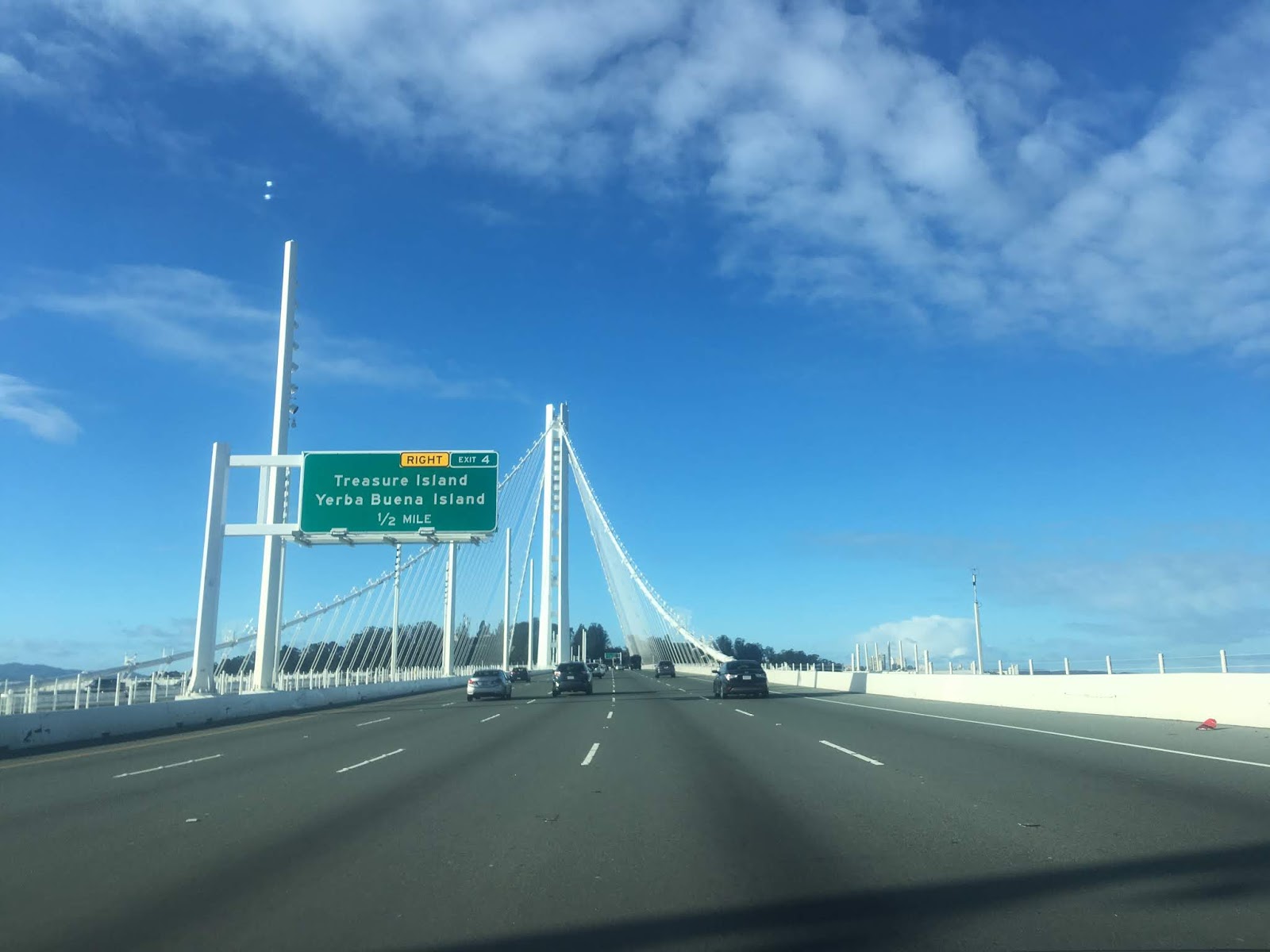
The eastern span of the Bay Bridge ascends to a central span on Yerba Buena Island. I-80 west Exit 4 provides access to Yerba Buena Island and Treasure Island.


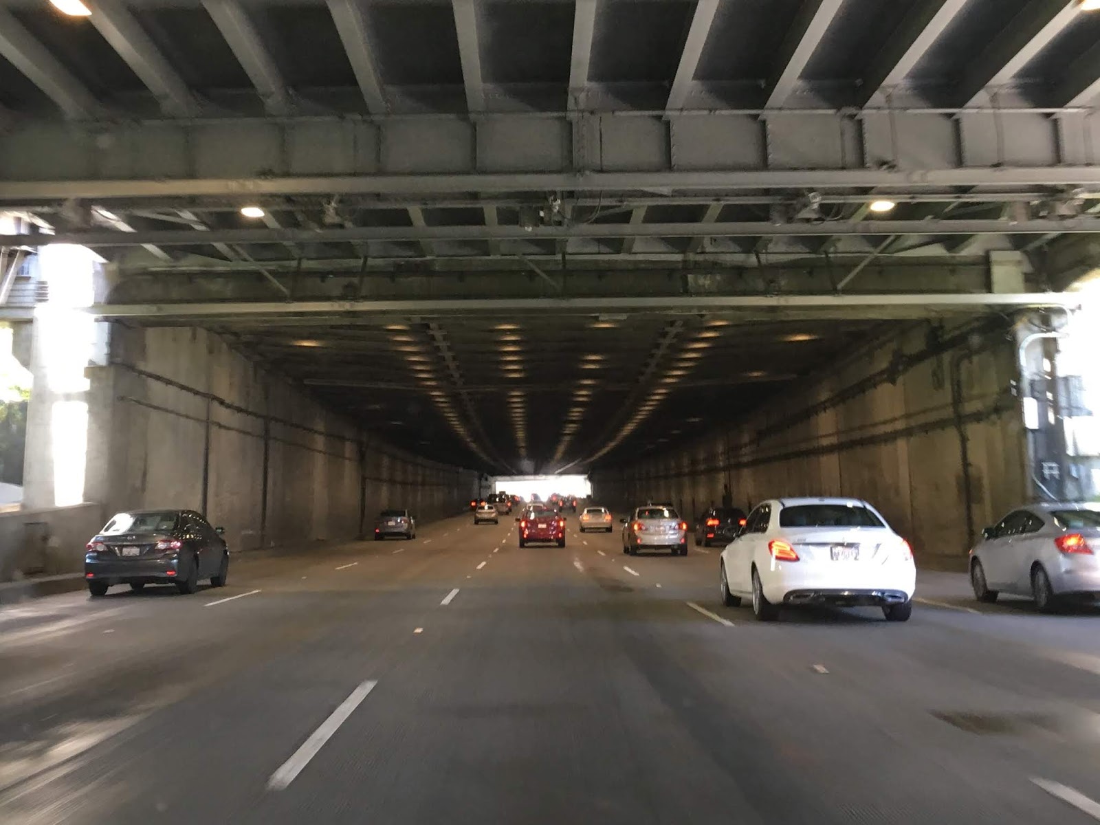
I-80 west traverses Yerba Buena Tunnel through the western span of the Bay Bridge.

The bus in the photo below is entering the western span of the Bay Bridge from Treasure Island Road.

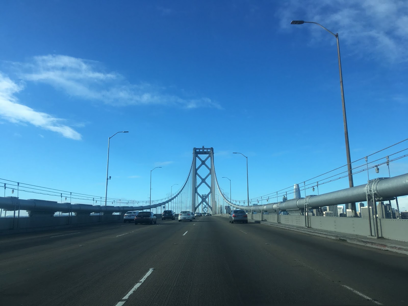
I-80 west on the western span of Bay Bridge approaches downtown San Francisco.


As stated above Exit 2C to Fremont Street and Folsom Street is the remaining segment of the Embarcadero Freeway. Access to the Embarcadero is signed from I-80 west via Exit 2B.


I-80 west lowers from western span of the Bay Bridge and begins to approach US 101. Exit 1A approaches US 101 south whereas Exit 1B approaches US 101 north and directs traffic to the Golden Gate Bridge.


This past month I had an expected return to San Francisco which allowed me an opportunity to take I-80 eastbound over the Bay Bridge. My approach to I-80 east was from US 101 north in San Francisco.


I-80 east begins with only two lanes from US 101 north. This low capacity junction generally creates a large traffic backup on I-80 east. That said, at least the view of downtown San Francisco is worth sitting around in traffic for.

I-80 east Exit 1 is located at 7th Street.


I-80 east traffic passes by a VMS sign past 7th Street before a guide sign advises that 4th Street is the last San Francisco Exit.


Exit 2 on I-80 east is the last access point for the City of San Francisco.


I-80 east crosses underneath the westbound lanes of the Interstate as it enters the Bay Bridge. The Bay Bridge is signed on I-80 east as "Willie L. Brown Jr. Bridge."


The previous rail lines used the left lanes of what is now I-80 east on the lower deck of the western span of the Bay Bridge. At Exit 4A access is signed from I-80 east to Treasure Island and Yerba Buena Island. Exit 4A is a rare left Interstate Exit.


I-80 east crosses through the Yerba Buena Tunnel before emerging on the eastern Bay Bridge span.


I-80 east crosses the eastern span of the Bay Bridge into Oakland. The new pedestrian path to Yerba Buena Island can be seen alongside the travel lanes of I-80 east.


In Oakland I-80 east meets I-580 and I-880. Access to I-880 south is signed from Exit 8A whereas access to I-580 east and by proxy CA 24 are signed via Exit 8B. I-80 east picks up the wrong-way concurrency of I-580 west.


Interestingly I hadn't driven the new eastern span of the Bay Bridge until this year. Prior to this year the last time I had been over the Bay Bridge was in 1993. Personally I find it kind of odd it took me so long to drive the new eastern span of the Bay Bridge considering I had driven every other major bridge in San Francisco Bay numerous times between 1993 and 2019. That being the case I decided to add some of my other photos of the Bay Bridge into this blog such as these from the Embarcadero.


The photos of the Bay Bridge below were taken from the Golden Gate Bridge in 2017.


Comments