On two recent Bay Area trips I drove several historic US Route alignments that predated the Golden Gate Bridge and San Francisco-Oakland Bay Bridge. One such early US Route alignment I've been trying to fully drive the past couple years was the first route of US 101 in San Francisco from Hyde Street Pier to the San Mateo County Line.

During the early 20th Century San Francisco was somewhat unique in that the Department of Public Works did not actually maintain any of the roadways within the city. On the north end of San Francisco Bay ferry service from Sausalito Point in Marin County connected Legislative Route Number 1 to San Francisco. From the south LRN 2 followed the path of the El Camino Real through San Mateo County and Daly City to the San Francisco City Limit. Neither LRN 1 or LRN 2 was maintained within the City Limits of San Francisco. Both LRN 1 and LRN 2 were part of the 1909 First State Highway Bond Act routes which were approved by voters in 1910.
CAhighways.org Highway Chronology Chapter 1
The 1917 State Highway Map below shows the State Maintenance Gap in San Francisco.
1917 State Highway Map
The first signed highways in San Francisco were the Auto Trails. Of note Auto Trails such as the Lincoln Highway and Pacific Highway began popping up in San Francisco as early as 1913. The El Camino Real was even promoted as something of an Auto Trail when bells were plotted along the corridor between Los Angeles and San Francisco following the historic route to the Spanish Missions. Bells along the promoted route of the El Camino Real were put in place as early as 1906. This 1920 Clason Map of California shows the promoted Auto Trails of the time.
1920 State Highway Map
By November of 1926 the US Route system was approved and US Route 101 was designated to run through San Francisco as a primary north/south highway. Even on early State Highways signage in Northern California was placed by the California State Automobile Association (CSAA). Unlike modern Caltrans (or the California Division of Highways) conventions the CSAA in addition to the Automobile Club of Southern California (ACSC) often signed highways on non-state maintained roadways.
From Sausalito Point US 101 was routed by ferry to Hyde Street Pier. From Hyde Street Pier US 101 used the following route through San Francisco:
- South on Hyde Street.
- West on Bay Street.
- South on Van Ness Avenue.
- West on Market Street.
- South on Valencia Street.
- Southwest on Mission Street to Daly City.
By 1929 US 101 was split into US 101W through San Francisco and US 101E through Oakland. The above of US 101 alignment can be seen on the 1930 State Highway City Insert.
1930 State Highway Map
In January of 1933 construction of the Golden Gate Bridge began followed by construction of the San Francisco-Oakland Bay Bridge in July 1933. As a result of the bridge construction the route of US 101W in San Francisco was picked up as an extension of LRN 2 in San Francisco and was rerouted. The new route of US 101W through San Francisco was as follows from Hyde Street Pier:
- South on Hyde Street.
- West on Bay Street.
- South on Van Ness Avenue.
- East on Fell Street.
- Southeast on 10th Street. US 101W was slated to pick up Bay Bridge traffic via Harrison Street and Bryant Street.
- South on Potrero Avenue.
- South on Bayshore Boulevard
- West on Alemany Boulevard.
- Southwest on San Jose Avenue to Daly City.
The above alignment of US 101W can be seen on the 1934 State Highway Map City Insert.
1934 State Highway Map City Insert
The 1935 California Division of Highways Map shows maintenance of LRN 2 following the above alignment of US 101W as far north as Van Ness Avenue and Lombard Street. Maintenance of LRN 2 swung west on Lombard Street to the Presidio of San Francisco.
1935 California Division of Highways Map of San Francisco
Likely by 1935 US 101 E/W was consolidated into a single US 101 running through San Francisco. In November of 1936 the Bay Bridge opened which extended US 40/US 50 into San Francisco where it met US 101 at 10th Street. By April of 1937 the Golden Gate Bridge was opened to traffic which eliminated the Hyde Street Pier Route of US 101. US 101 was split into US 101A via Alemany Boulevard and San Jose Avenue to Daly City whereas the US 101 Mainline followed Bayshore Boulevard on LRN 68. The complete ferry-free US 101 in San Francisco can be first seen on the 1938 State Highway Map City Insert.
1938 State Highway Map City Insert
By 1939 the mainline of US 101 was shifted back to it's surface alignment after local opposition and the new Bayshore Freeway route on LRN 68 was assigned as US 101 Bypass. This change can be seen on the 1940 State Highway Map City Insert.
1940 State Highway Map City Insert
With all the original historic alignment of US 101 in mind, can it actually be driven? In short answer is yes southbound but northbound requires a minor detour. That being the case my drive was southbound on historic US 101 from Hyde Street Pier.
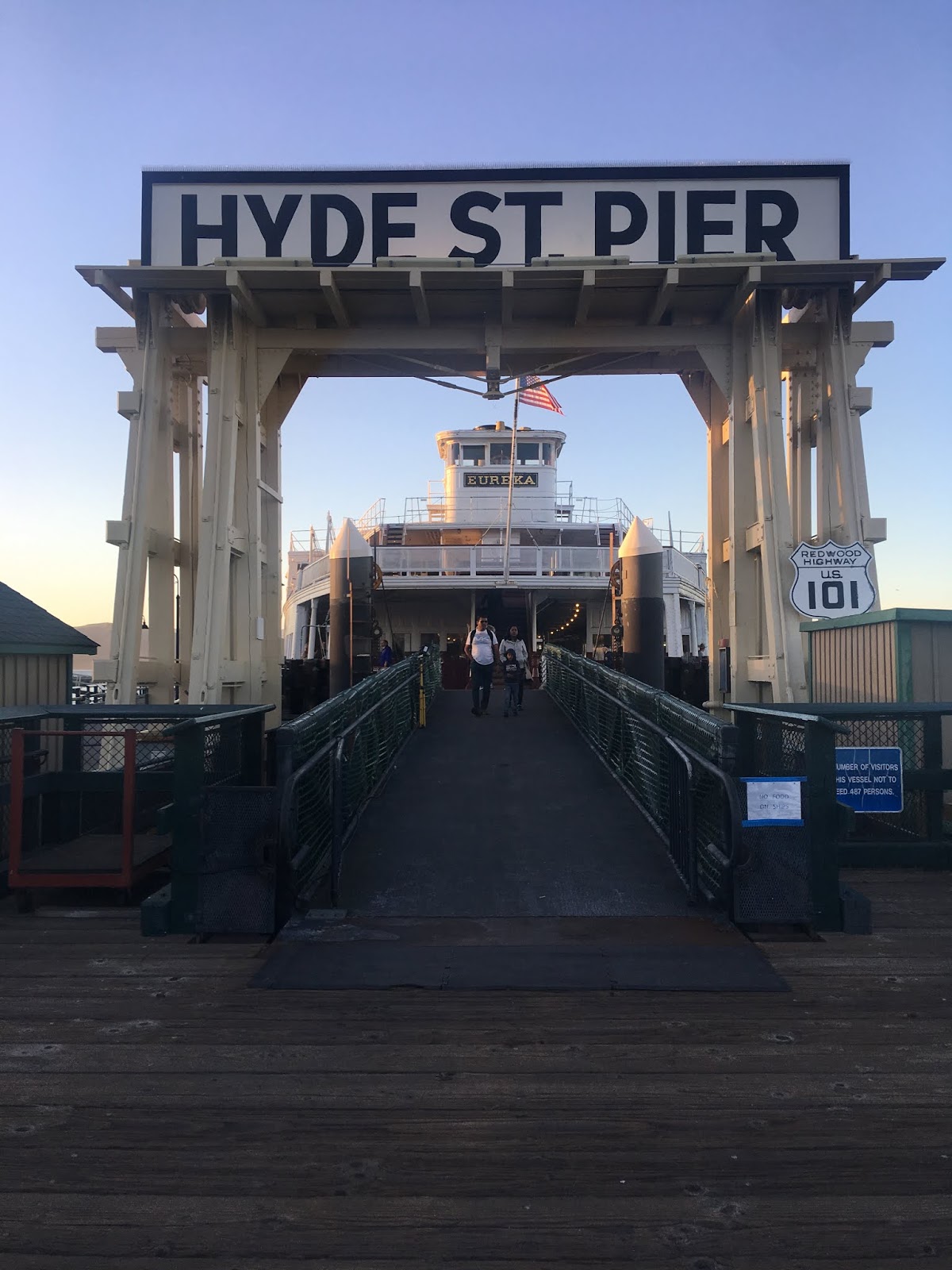
Hyde Street Pier opened in 1922 and was purpose built to receive car ferries coming from Sausalito Point. Hyde Street Pier is now part of San Francisco Maritime National Historic Park and can be toured as a National Park Service exhibit.

Hyde Street Pier still displays it's US 101 "Redwood Highway" shield.

A centerpiece to Hyde Street Pier is the Eureka car ferry ship. The Eureka was one of the ships that moved cars along US 101 from Sausalito Point over San Francisco Bay to San Francisco. The Eureka was built in 1890 and was designated as the Tiburon until it was retrofitted in 1922.

The Eureka is filled with vehicles that would have dated back to the heyday of ferry service to Hyde Street Pier.


Traffic on US 101 southbound would have seen a far less modern skyline disembarking the Eureka in the 1920s and 1930s.

From Hyde Street Pier US 101 southbound would have headed south on Hyde Street. Hyde Street almost immediately begins to ascend Russian Hill.

The grade on Hyde Street ascending Russian Hill is extremely steep. Russian Hill is more known for the curvy segment of Lombard Street and is one of the original Seven Hills in the city.

Traffic heading to modern US 101 on southbound Hyde Street is directed to turn onto North Pointe Street.

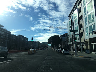
Southbound US 101 would have originally stayed on Hyde Street to Bay Street where it would have taken a right hand turn onto Bay Street.


Historic US 101 southbound would have stayed on Bay Street and taken a left hand turn onto Van Ness Avenue.


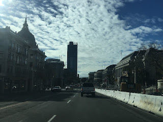
At Lombard Street the historical alignment of US 101 on Van Ness Avenue picks up the modern highway.

Van Ness Avenue is still a very section of US 101 south and has to carry the weight of rush hour traffic every day. That being the case Van Ness Avenue tends to have poor asphalt condition and is very rough to drive on.


At Broadway US 101 south traffic would have picked up traffic emerging from the Embarcadero Freeway via the Broadway Tunnel. I-480 was to continue westward from the Embarcadero to the Golden Gate Bridge where it would have shared a terminus at I-280. The Embarcadero Freeway dates back to 1947 when the route of LRN 224 was approved. The 1948 State Highway Map City Insert shows the planned freeway connecting to US 101 at Lombard Street and Van Ness (1948 City Insert Map). The early versions of planned route of the Embarcadero Freeway would have required a large tunnel through Russian Hill.

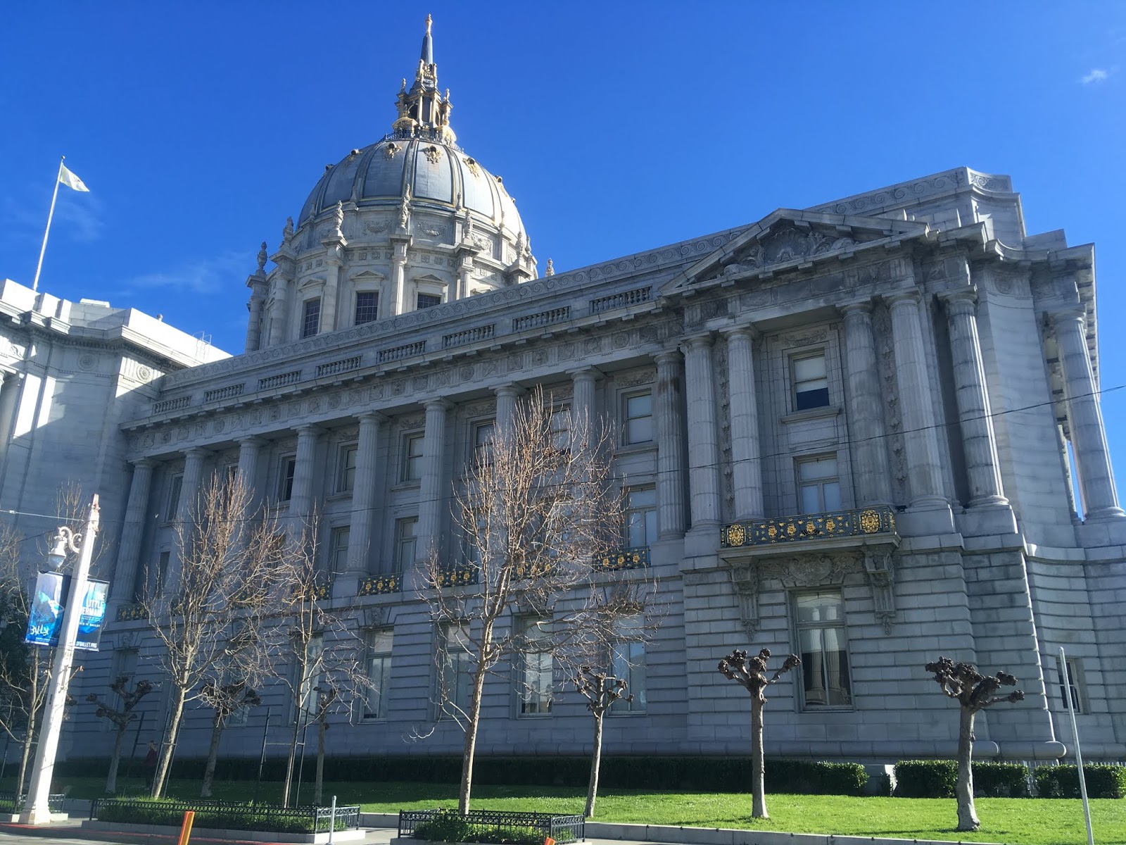
US 101 south continues on Van Ness Avenue and intersects San Francisco City Hall at McAllister Street.


The current San Francisco City Hall building was completed in 1916 and replaced the 1899 City Hall which was destroyed in the 1906 San Francisco Earthquake.


When LRN 2 was extended into San Francisco the route of US 101W south was shifted off of Van Ness Avenue two blocks south of San Francisco City Hall. The original alignment of US 101 south and US 101W south continued to Market Street where it would have made a right hand turn. Interestingly traffic can no longer replicate the original northbound route of US 101 as left hand turns from Market Street onto Van Ness Avenue are no longer possible.


The original route of US 101 south would have turned left off Market Street onto Valenica Street.

Valencia Street south almost immediately crosses under the Central Freeway which was part of US 101 until parts of it were damaged in the 1989 Loma Prieta Earthquake. Following the Loma Prieta Earthquake US 101 was scaled back to Van Ness Avenue but part of the Central Freeway remains west to Octavia Street and Market Street.

US 101 south would have originally continued on Valencia Street to Mission Street where it would have made a right hand turn. At 16th Street Mission San Francisco de Asis is located two blocks west of Valencia Street on Dorles Street. Mission San Francisco de Asis was founded in 1776 and the present Mission was completed in 1791. The 1791 adobe Mission is the oldest structure standing in San Francisco and was part of the El Camino Real.


US 101 south originally followed Mission Street to Daly City in San Mateo County. Mission Street crosses over I-280 just north of Alemany Boulevard.


In Daly City traffic on Mission Street can no longer follow the original route of US 101 south of Flournoy Street. Traffic on Mission Street south is forced to turn on Flournoy Street. A right hand turn on Flournoy Street takes traffic the second alignment of US 101 on San Jose Avenue on CA 82.


For more information on former US 101 on CA 82 please refer to the blog below.
California State Route 82/Old US Route 101 south from San Francisco to I-380
During the early 20th Century San Francisco was somewhat unique in that the Department of Public Works did not actually maintain any of the roadways within the city. On the north end of San Francisco Bay ferry service from Sausalito Point in Marin County connected Legislative Route Number 1 to San Francisco. From the south LRN 2 followed the path of the El Camino Real through San Mateo County and Daly City to the San Francisco City Limit. Neither LRN 1 or LRN 2 was maintained within the City Limits of San Francisco. Both LRN 1 and LRN 2 were part of the 1909 First State Highway Bond Act routes which were approved by voters in 1910.
CAhighways.org Highway Chronology Chapter 1
The 1917 State Highway Map below shows the State Maintenance Gap in San Francisco.
1917 State Highway Map
The first signed highways in San Francisco were the Auto Trails. Of note Auto Trails such as the Lincoln Highway and Pacific Highway began popping up in San Francisco as early as 1913. The El Camino Real was even promoted as something of an Auto Trail when bells were plotted along the corridor between Los Angeles and San Francisco following the historic route to the Spanish Missions. Bells along the promoted route of the El Camino Real were put in place as early as 1906. This 1920 Clason Map of California shows the promoted Auto Trails of the time.
1920 State Highway Map
By November of 1926 the US Route system was approved and US Route 101 was designated to run through San Francisco as a primary north/south highway. Even on early State Highways signage in Northern California was placed by the California State Automobile Association (CSAA). Unlike modern Caltrans (or the California Division of Highways) conventions the CSAA in addition to the Automobile Club of Southern California (ACSC) often signed highways on non-state maintained roadways.
From Sausalito Point US 101 was routed by ferry to Hyde Street Pier. From Hyde Street Pier US 101 used the following route through San Francisco:
- South on Hyde Street.
- West on Bay Street.
- South on Van Ness Avenue.
- West on Market Street.
- South on Valencia Street.
- Southwest on Mission Street to Daly City.
By 1929 US 101 was split into US 101W through San Francisco and US 101E through Oakland. The above of US 101 alignment can be seen on the 1930 State Highway City Insert.
1930 State Highway Map
In January of 1933 construction of the Golden Gate Bridge began followed by construction of the San Francisco-Oakland Bay Bridge in July 1933. As a result of the bridge construction the route of US 101W in San Francisco was picked up as an extension of LRN 2 in San Francisco and was rerouted. The new route of US 101W through San Francisco was as follows from Hyde Street Pier:
- South on Hyde Street.
- West on Bay Street.
- South on Van Ness Avenue.
- East on Fell Street.
- Southeast on 10th Street. US 101W was slated to pick up Bay Bridge traffic via Harrison Street and Bryant Street.
- South on Potrero Avenue.
- South on Bayshore Boulevard
- West on Alemany Boulevard.
- Southwest on San Jose Avenue to Daly City.
The above alignment of US 101W can be seen on the 1934 State Highway Map City Insert.
1934 State Highway Map City Insert
The 1935 California Division of Highways Map shows maintenance of LRN 2 following the above alignment of US 101W as far north as Van Ness Avenue and Lombard Street. Maintenance of LRN 2 swung west on Lombard Street to the Presidio of San Francisco.
1935 California Division of Highways Map of San Francisco
Likely by 1935 US 101 E/W was consolidated into a single US 101 running through San Francisco. In November of 1936 the Bay Bridge opened which extended US 40/US 50 into San Francisco where it met US 101 at 10th Street. By April of 1937 the Golden Gate Bridge was opened to traffic which eliminated the Hyde Street Pier Route of US 101. US 101 was split into US 101A via Alemany Boulevard and San Jose Avenue to Daly City whereas the US 101 Mainline followed Bayshore Boulevard on LRN 68. The complete ferry-free US 101 in San Francisco can be first seen on the 1938 State Highway Map City Insert.
1938 State Highway Map City Insert
By 1939 the mainline of US 101 was shifted back to it's surface alignment after local opposition and the new Bayshore Freeway route on LRN 68 was assigned as US 101 Bypass. This change can be seen on the 1940 State Highway Map City Insert.
1940 State Highway Map City Insert
With all the original historic alignment of US 101 in mind, can it actually be driven? In short answer is yes southbound but northbound requires a minor detour. That being the case my drive was southbound on historic US 101 from Hyde Street Pier.
Hyde Street Pier opened in 1922 and was purpose built to receive car ferries coming from Sausalito Point. Hyde Street Pier is now part of San Francisco Maritime National Historic Park and can be toured as a National Park Service exhibit.

Hyde Street Pier still displays it's US 101 "Redwood Highway" shield.

A centerpiece to Hyde Street Pier is the Eureka car ferry ship. The Eureka was one of the ships that moved cars along US 101 from Sausalito Point over San Francisco Bay to San Francisco. The Eureka was built in 1890 and was designated as the Tiburon until it was retrofitted in 1922.

The Eureka is filled with vehicles that would have dated back to the heyday of ferry service to Hyde Street Pier.


Traffic on US 101 southbound would have seen a far less modern skyline disembarking the Eureka in the 1920s and 1930s.

From Hyde Street Pier US 101 southbound would have headed south on Hyde Street. Hyde Street almost immediately begins to ascend Russian Hill.

The grade on Hyde Street ascending Russian Hill is extremely steep. Russian Hill is more known for the curvy segment of Lombard Street and is one of the original Seven Hills in the city.

Traffic heading to modern US 101 on southbound Hyde Street is directed to turn onto North Pointe Street.

Southbound US 101 would have originally stayed on Hyde Street to Bay Street where it would have taken a right hand turn onto Bay Street.


Historic US 101 southbound would have stayed on Bay Street and taken a left hand turn onto Van Ness Avenue.


At Lombard Street the historical alignment of US 101 on Van Ness Avenue picks up the modern highway.

Van Ness Avenue is still a very section of US 101 south and has to carry the weight of rush hour traffic every day. That being the case Van Ness Avenue tends to have poor asphalt condition and is very rough to drive on.


At Broadway US 101 south traffic would have picked up traffic emerging from the Embarcadero Freeway via the Broadway Tunnel. I-480 was to continue westward from the Embarcadero to the Golden Gate Bridge where it would have shared a terminus at I-280. The Embarcadero Freeway dates back to 1947 when the route of LRN 224 was approved. The 1948 State Highway Map City Insert shows the planned freeway connecting to US 101 at Lombard Street and Van Ness (1948 City Insert Map). The early versions of planned route of the Embarcadero Freeway would have required a large tunnel through Russian Hill.

US 101 south continues on Van Ness Avenue and intersects San Francisco City Hall at McAllister Street.


The current San Francisco City Hall building was completed in 1916 and replaced the 1899 City Hall which was destroyed in the 1906 San Francisco Earthquake.

When LRN 2 was extended into San Francisco the route of US 101W south was shifted off of Van Ness Avenue two blocks south of San Francisco City Hall. The original alignment of US 101 south and US 101W south continued to Market Street where it would have made a right hand turn. Interestingly traffic can no longer replicate the original northbound route of US 101 as left hand turns from Market Street onto Van Ness Avenue are no longer possible.


The original route of US 101 south would have turned left off Market Street onto Valenica Street.

Valencia Street south almost immediately crosses under the Central Freeway which was part of US 101 until parts of it were damaged in the 1989 Loma Prieta Earthquake. Following the Loma Prieta Earthquake US 101 was scaled back to Van Ness Avenue but part of the Central Freeway remains west to Octavia Street and Market Street.

US 101 south would have originally continued on Valencia Street to Mission Street where it would have made a right hand turn. At 16th Street Mission San Francisco de Asis is located two blocks west of Valencia Street on Dorles Street. Mission San Francisco de Asis was founded in 1776 and the present Mission was completed in 1791. The 1791 adobe Mission is the oldest structure standing in San Francisco and was part of the El Camino Real.


US 101 south originally followed Mission Street to Daly City in San Mateo County. Mission Street crosses over I-280 just north of Alemany Boulevard.


In Daly City traffic on Mission Street can no longer follow the original route of US 101 south of Flournoy Street. Traffic on Mission Street south is forced to turn on Flournoy Street. A right hand turn on Flournoy Street takes traffic the second alignment of US 101 on San Jose Avenue on CA 82.


For more information on former US 101 on CA 82 please refer to the blog below.
California State Route 82/Old US Route 101 south from San Francisco to I-380
Comments