Upon leaving Williams and former US Route 66/89 I headed east on Interstate 40 to Flagstaff. From Flagstaff I pulled onto Interstate 17 south to approach former US Route 89A on the current Arizona State Route 89A.

This article serves at the 24th entry in the 2016 Fall Mountain Trip Series. Part 23 regarding former US Route 66/89 in Williams can be found below:
2016 Fall Mountain Trip Part 23; former US Route 66 and US Route 89 in Williams
AZ 89A is a 83.85 mile State Highway which begins at former US 66/89 (current I-40BL) on Milton Road near downtown Flagstaff and ends at AZ 89 via the Pioneer Parkway in Prescott. AZ 89A mostly consists of highway which made up US 89A and the first AZ 79. AZ 89A is one of Arizona's most scenic highways which includes the; Sedona-Oak Creek Canyon Scenic Road, part of the signed former US Route 89A on the Jerome-Clarkdale-Cottonwood Historic Road, and the Mingus Mountain Scenic Road. AZ 89A has a 7.22 mile spur on Fain Road in Prescott Valley which ends at AZ 69. AZ 89A is one of my favorite highways not just in Arizona but anywhere in the United States and holds a lot of fond weekend memories for me.
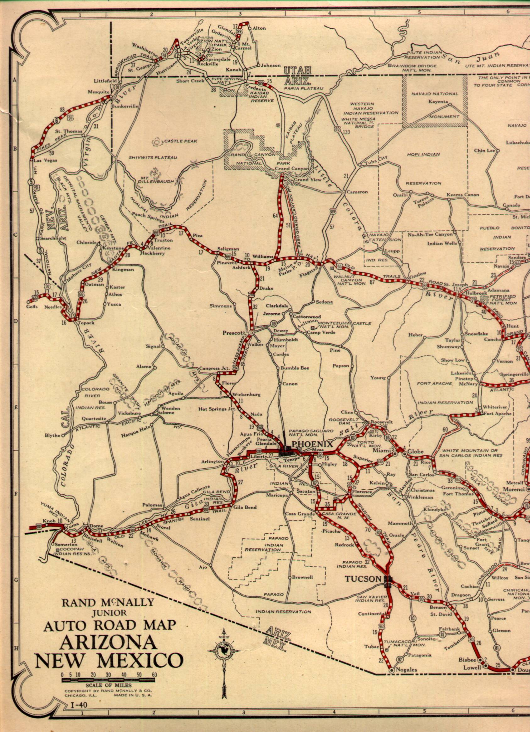
The route over Mingus Mountain between Prescott and Clarkdale was part of the signed Arizona Auto Club Auto Trail System which can be seen on the 1925 Rand McNally Highway Map of Arizona/New Mexico.


The Arizona State Highway System was created in 1927 to supplement the new US Route System. AZ 89 from Prescott over Mingus Mountain/Jerome to Clarkdale was one of the original State Highways but was planned from the outset to reach Flagstaff via existing ungraded roads. AZ 89 was probably at one point intended to be the mainline route of US 89 south of Flagstaff. Current AZ 89A can be seen on the 1927 Rand McNally Highway Map of Arizona/New Mexico between Prescott and Clarkdale as AZ 89. Note; AZ 89 on the 1927 Rand McNally Map is shown originating at US 280 in Prescott which ultimately became mainline US 89 in the final US Route System.

By 1929 AZ 89 had been renumbered to AZ 79 as US 89 had been extended over what was US 280. The improved AZ 79 by 1929 reached the City of Sedona but grading was not completed through Oak Creek Canyon. AZ 79 appears on the 1931 Clason Highway Map of Arizona/New Mexico as being graded to Sedona and signed through Oak Creek Canyon to Flagstaff.

By 1935 AZ 79 between Sedona and Flagstaff had been fully graded through Oak Creek Canyon. AZ 79 is shown graded on the 1935 Arizona State Highway Department Map.

By 1938 the entirety of AZ 79 was paved which can be seen on the 1938 Rand McNally Map of Arizona.

In 1941 AZ 79 became US Route 89A which can be seen on the 1944 Rand McNally Highway Map of Arizona.

As noted above my approach to AZ 89A was from I-40 east onto I-17 south in Flagstaff in Coconino County. AZ 89A and I-17 immediately south of Flagstaff are multiplexed.

South of the City Limits of Flagstaff AZ 89A splits from I-17 at Exit 337 into Coconino National Forest towards Oak Creek Canyon and Sedona.


AZ 89A follows the Sedona-Oak Creek Canyon Road towards the Mogollon Rim and Oak Creek Canyon. The Mogollon Rim is the defining feature of much of the Southern Colorado Plateau which spans from Yavapai County east towards the New Mexico State Line. Oak Creek Canyon is 12 miles long and ranges in depths from 800 feet to 2,000 feet. Given the close proximity of Oak Creek Canyon to places like Sedona it has become the second most frequented tourist destination in Arizona after the Grand Canyon. The Oak Creek Vista shows the top of Oak Creek Canyon at 6,420 feet above sea level. Flagstaff is listed 12 miles north whereas Sedona is shown as 16 miles south on AZ 89A.

Suffice to say the vista of Oak Creek Canyon is worthwhile stopping to see. AZ 89A can be seen snaking through Oak Creek Canyon.


As I stated above AZ 89A was one of my favorite drives when I lived in Arizona. That being the case I have numerous photos of Oak Creek Canyon such as these from 2012.

Or how about during overcast skies in 2015?


AZ 89A south through Oak Creek Canyon passes by several notable hiking trails and destinations; mostly notably Slide Rock State Park. At the Wilson Mountain Trailhead AZ 89A crosses the 1938 Midgley Bridge. The 1938 Midgley Bridge features a steel arch design and was one of the center pieces of the late construction of AZ 79 from Sedona north to Flagstaff. The Midgley Bridge is 373.7 feet and spans Wilson Canyon.

AZ 89A emerges from Oak Creek Canyon into downtown Sedona. After passing through a roundabout AZ 89A intersects AZ 179 at a second roundabout (seriously Sedona is roundabout hell). The numbering of AZ 179 is a call back to the days of AZ 79.


While passing through Sedona I made a detour onto Airport Road to climb atop Airport Mesa. Airport Mesa overlooks the entirety of Sedona and the red sandstone canyons of the Mogollon Rim. The City of Sedona lies at an elevation of 4,350 feet above sea level which creates some striking views with the Mogollon Rim and Oak Creek Canyon being so close by. Post Office Service in Sedona began in 1902 when the community only had 55 residents. These photos below are from Airport Mesa in 2015 when the skies were overcast.


As AZ 89A south exits the City of Sedona it enters Yavapai County and begins to descend into Verde Valley. AZ 89A south of Sedona is an expressway and first has a major intersection at Yavapai County Route 50 at Page Springs Road.

AZ 89A southbound enters the City of Cottonwood. At the intersection of Mingus Avenue AZ 89A intersects Historic US 89A whereas Cornville Road is signed as Yavapai County Route 30. I pulled onto Historic US 89A towards downtown Cottonwood.


Historic US 89A approaches downtown Cottonwood via Mingus Avenue (crossing the Verde River in the process) and Main Street. Cottonwood was plotted out in 1908 given it had a favorable location near the mines of the Black Hills and Jerome. In 1912 a smelter was built what is now nearby Clarkdale along with another at the company town of Clemenceau in 1917. The Clemeanceau smelter closed in 1936 which was followed by the Copper Industry declining in the 1950s. Unlike Clemeanceau, Clarkdale, and Jerome the decline of the mining industry didn't affect Cottonwood as greatly. Cottonwood incorporated as a City in 1960, today it has a population of approximately 11,000.

Historic US 89A transitions onto Broadway upon entering Cottonwood.

At Tuzigoot Road there is access from Historic US 89A to the Verde River and Tuzigoot National Monument. Tuzigoot National Monument protects a two/three story pueblo which lies on a ridge above the Verde River. The ruins at Tuzigoot National Monument were constructed by the Sinagua tribe between 1125-1400 CE and is the largest pueblo in Verde Valley. The ruins at Tuzigoot National Monument was once owned by Phelps Dodge and the United Verde Mining company. Eventually the land rights to the ruins at Tuzigoot were sold to Yavapai County and were declared a National Monument in July 1939. These photos of Tuzigoot National Monument were taken back in 2011.


Historic US 89A transitions from Broadway onto Main Street in downtown Clarkdale.


As noted above Clarkdale was founded in 1912 when a smelter and Verde Canyon Railroad were constructed, the community is located at 3,545 feet above sea level. The Verde Canyon Railroad (a standard gauge line) connected via Perkinsville to the ATSF mainline in Drake whereas it reached Jerome via a spur line. Clarkdale was built specifically for the mine of William A Clark for which the community is named. Clarkdale was known in the early 20th century as being one of the most modernized mining communities in Arizona as it had; telegraphs, sewer services, a planned street grid, and electrical grid. After Clark's mine closed in 1953 the community of Clarkdale declined significantly. Clarkdale incorporated in 1957 and the community stabilized in 1959 when a Phoenix Cement Plant opened. The Verde Canyon Railroad was purchased in 1988 and has been in operation as a tourist line since.


Historic US 89A follows Main Street and Clarkdale Parkway back to modern AZ 89A. I followed modern AZ 89A south towards Jerome.


AZ 89A southbound begins a rapid climb into the Black Hills and is co-signed as Historic US 89A. AZ 89A enters the community of Jerome via Hampshire Avenue. From a wayside at the Jerome Art Center the entire community of Jerome can be viewed from a distance.


The United Verde Mine and Jerome State Historic Park are obvious from the Jerome Art Center. Jerome State Historic Park is housed out of the 1916 Douglas Mansion. The Douglas Mansion is built directly above the Little Daisy Mine.

North of Douglas Mansion the grade of the Verde Canyon Railroad spur line can be seen cut into the mountainside.

A look back north reveals a vista of the Mogollon Rim.

Of course the entire vista of Jerome and the Mogollon Rim pretty awesome too in panoramic form.

AZ 89A follows Main Street into downtown Jerome. AZ 89A south splits off one-way onto Hull Avenue whereas the northbound lane stays on Main Street. Most of Jerome is 5,000 feet above sea level or higher.


The first copper claims in the Black Hills near Jerome were filed in 1876 by Angus McKinnon and Morris Ruffner. These claims were purchased in 1880 by Arizona Territorial Governor Fredrick Tritle. In 1883 the United Verde Copper Company was founded by money invested by James A. MacDonald and Eugene Jerome. The United Verde Copper Company built a smelter in the new town of Jerome and built a stage line over Mingus Mountain to Prescott.
In 1888 William A. Clark purchased the United Verde Copper Company after having mining success in Montana. In 1895 the United Verde & Pacific Railroad was completed as a narrow gauge line which connected to Jerome Junction 26.3 miles to the west near modern Chino Valley. Ultimately the United Verde & Pacific Railroad would be replaced by the Verde Canyon Railroad and shuttered by 1920. Jerome incorporated in 1899 and reached a population of 2,500 by 1900. By 1900 the United Verde Mine was the largest Copper Mine in Arizona and was among the largest in the world.
The demands of World War I greatly increased the demand for copper which led to a population boom in Jerome and Verde Valley in the 1910s. By 1916 there was 22 mining companies located in Jerome which employed over 3,000 workers. In 1919 the United Verde Mine became an open pit which reduced the number of fires which used to plague the Town of Jerome. Jerome reached it's peak during the 1920s when it reached a population of over 10,000 during a Post World War I copper boom.
Phelps Dodge shuttered the United Verde Mine in 1953 which led to a major decline in Jerome. The population of Jerome dropped below 100 before many investors in Arizona began to realize the opportunity the town presented as a tourist destination. Long past it's prime as a mining community the Town of Jerome now exists as one of the most popular weekend destinations for visitation out of the Phoenix Area. Jerome today is lined with modern shops, museums, and restaurants that fill the vintage mining area buildings.
Downtown Jerome was constructed in leveled tiers with the lowest being Hull Avenue. The tiered levels of Jerome have been infamous for structures subsiding down the mountainside which is most apparent in the form the Sliding Jail. The Sliding Jail was constructed in 1905 as the 3rd Town Jail of Jerome. The Sliding Jail was originally located between Main Street and Hull Avenue. During the 1930s the Sliding Jail detached from it's wooden frame which led it to gradual settle into the middle of Hull Avenue. The Sliding Jail was pushed further downhill north of Hull Avenue where it can be found today.


A look uphill from the Sliding Jail southward into downtown Jerome.

Some of the ruined structures along 1st Avenue.


A look down at the Douglas Hotel of Jerome State Historic Park and the Little Daisy Mine from 1st Avenue. The Mogollon Rim and the cement plant near Clarkdale can be seen off in the distance.

A fully ruined structure along 1st Avenue.

A vintage gas pump can be found in from of the Merchant's Gathering Building at Hull Avenue and 1st Avenue.

Southbound AZ 89A follows Jerome Avenue back to Main Street and northbound AZ 89A on the second tier of Jerome.


A look on Main Street on northbound AZ 89A.


A heavily weathered structure located at the intersection of Main Street and 1st Avenue.


Jerome Town Hall near the intersection of Main Street and 1st Avenue.

The 1898 Hotel Conner Building located at the corner of Jerome Street and Main Street.

A small museum is located in the basement of the New State Motor Company building on Main Street.

AZ 89A south loops up to the third tier of Jerome via Clark Street at the intersection of Perkinsville Road.


AZ 89A southbound on Clark Street from the third tier of Jerome takes a narrow path out of town to the Mingus Mountain Scenic Road.

AZ 89A south of Jerome enters Prescott National Forest and begins to ascend through Hull Canyon.

The ruins of the United Verde Central Shaft can be found off of AZ 89A within Hull Canyon.


AZ 89A climbs out of Hull Canyon onto the flanks of Mingus Mountain through a series of switchbacks. There are some really nice views of the Mogollon Rim making the ascent on southbound AZ 89A.


The view from one of the switchbacks facing the United Verde Central Shaft.

AZ 89A climbs to 7,023 feet above sea level atop Mingus Mountain on a highly curvy grade. The current route of AZ 89A over Mingus Mountain essentially is the same road that was built in 1883 to run stages from Jerome to Prescott. The summit of Mingus Mountain is located east of AZ 89A at an elevation of 7,818 feet above sea level.

Upon crossing Mingus Mountain I followed AZ 89A to Fain Road and Pioneer Parkway. Fain Road doesn't carry any AZ 89A signage but rather "TO AZ 69." I followed Fain Road/AZ 89A Spur towards AZ 69 and I-17.

Part 25 of the 2016 Fall Mountain Trip series covers the history of AZ 69, AZ 79 (ii), and Interstate 17.
2016 Fall Mountain Trip Part 25; AZ 69 and I-17 to Phoenix (the history of AZ 69, AZ 79 ii, and I-17)

2016 Fall Mountain Trip Part 23; former US Route 66 and US Route 89 in Williams
AZ 89A is a 83.85 mile State Highway which begins at former US 66/89 (current I-40BL) on Milton Road near downtown Flagstaff and ends at AZ 89 via the Pioneer Parkway in Prescott. AZ 89A mostly consists of highway which made up US 89A and the first AZ 79. AZ 89A is one of Arizona's most scenic highways which includes the; Sedona-Oak Creek Canyon Scenic Road, part of the signed former US Route 89A on the Jerome-Clarkdale-Cottonwood Historic Road, and the Mingus Mountain Scenic Road. AZ 89A has a 7.22 mile spur on Fain Road in Prescott Valley which ends at AZ 69. AZ 89A is one of my favorite highways not just in Arizona but anywhere in the United States and holds a lot of fond weekend memories for me.
The route over Mingus Mountain between Prescott and Clarkdale was part of the signed Arizona Auto Club Auto Trail System which can be seen on the 1925 Rand McNally Highway Map of Arizona/New Mexico.


The Arizona State Highway System was created in 1927 to supplement the new US Route System. AZ 89 from Prescott over Mingus Mountain/Jerome to Clarkdale was one of the original State Highways but was planned from the outset to reach Flagstaff via existing ungraded roads. AZ 89 was probably at one point intended to be the mainline route of US 89 south of Flagstaff. Current AZ 89A can be seen on the 1927 Rand McNally Highway Map of Arizona/New Mexico between Prescott and Clarkdale as AZ 89. Note; AZ 89 on the 1927 Rand McNally Map is shown originating at US 280 in Prescott which ultimately became mainline US 89 in the final US Route System.


By 1935 AZ 79 between Sedona and Flagstaff had been fully graded through Oak Creek Canyon. AZ 79 is shown graded on the 1935 Arizona State Highway Department Map.

By 1938 the entirety of AZ 79 was paved which can be seen on the 1938 Rand McNally Map of Arizona.

In 1941 AZ 79 became US Route 89A which can be seen on the 1944 Rand McNally Highway Map of Arizona.

The Sedona-Oak Creek Canyon Scenic Road was designated in August 1984. The Sedona-Oak Creek Canyon Scenic Road consists of 14.5 mile segment of AZ 89A from Flagstaff south through Oak Creek Canyon to Sedona. Historic US 89A was designated in May 1992 as a scenic route through downtown Clarkdale and Cottonwood along with the Mingus Mountain Scenic Road. Historic US 89A is part of the original route of AZ 89/AZ 79/US 89A and is approximately 10 miles in length. The Mingus Mountain Scenic Road consists of a 11.5 mile part of AZ 89A from Jerome south over the Black Hills.
US 89A between Prescott and Flagstaff became designated as AZ 89A when the mainline route of US 89 was truncated to Flagstaff. AZ 79 had been recycled earlier in 1992 over what had been a segment of US 80/US 89 hence why the number of "89A" had been retained. Prior to 2001 AZ 89A was aligned through Granite Dells near Prescott Valley before it had been realigned onto the Pioneer Parkway. The former route of AZ 89A through Granite Dells appears on some maps as "Old US Route 89A. Pictures of the construction of the Pioneer Parkway can be found on the ArizonaRoads.com AZ 89A Page. What is now the Fain Road Expressway is an unsigned spur of AZ 89A which was recently completed but was planned to as AZ 48.
As noted above my approach to AZ 89A was from I-40 east onto I-17 south in Flagstaff in Coconino County. AZ 89A and I-17 immediately south of Flagstaff are multiplexed.

South of the City Limits of Flagstaff AZ 89A splits from I-17 at Exit 337 into Coconino National Forest towards Oak Creek Canyon and Sedona.


AZ 89A follows the Sedona-Oak Creek Canyon Road towards the Mogollon Rim and Oak Creek Canyon. The Mogollon Rim is the defining feature of much of the Southern Colorado Plateau which spans from Yavapai County east towards the New Mexico State Line. Oak Creek Canyon is 12 miles long and ranges in depths from 800 feet to 2,000 feet. Given the close proximity of Oak Creek Canyon to places like Sedona it has become the second most frequented tourist destination in Arizona after the Grand Canyon. The Oak Creek Vista shows the top of Oak Creek Canyon at 6,420 feet above sea level. Flagstaff is listed 12 miles north whereas Sedona is shown as 16 miles south on AZ 89A.

Suffice to say the vista of Oak Creek Canyon is worthwhile stopping to see. AZ 89A can be seen snaking through Oak Creek Canyon.


As I stated above AZ 89A was one of my favorite drives when I lived in Arizona. That being the case I have numerous photos of Oak Creek Canyon such as these from 2012.

Or how about during overcast skies in 2015?


AZ 89A south through Oak Creek Canyon passes by several notable hiking trails and destinations; mostly notably Slide Rock State Park. At the Wilson Mountain Trailhead AZ 89A crosses the 1938 Midgley Bridge. The 1938 Midgley Bridge features a steel arch design and was one of the center pieces of the late construction of AZ 79 from Sedona north to Flagstaff. The Midgley Bridge is 373.7 feet and spans Wilson Canyon.

AZ 89A emerges from Oak Creek Canyon into downtown Sedona. After passing through a roundabout AZ 89A intersects AZ 179 at a second roundabout (seriously Sedona is roundabout hell). The numbering of AZ 179 is a call back to the days of AZ 79.


While passing through Sedona I made a detour onto Airport Road to climb atop Airport Mesa. Airport Mesa overlooks the entirety of Sedona and the red sandstone canyons of the Mogollon Rim. The City of Sedona lies at an elevation of 4,350 feet above sea level which creates some striking views with the Mogollon Rim and Oak Creek Canyon being so close by. Post Office Service in Sedona began in 1902 when the community only had 55 residents. These photos below are from Airport Mesa in 2015 when the skies were overcast.


As AZ 89A south exits the City of Sedona it enters Yavapai County and begins to descend into Verde Valley. AZ 89A south of Sedona is an expressway and first has a major intersection at Yavapai County Route 50 at Page Springs Road.

AZ 89A southbound enters the City of Cottonwood. At the intersection of Mingus Avenue AZ 89A intersects Historic US 89A whereas Cornville Road is signed as Yavapai County Route 30. I pulled onto Historic US 89A towards downtown Cottonwood.


Historic US 89A approaches downtown Cottonwood via Mingus Avenue (crossing the Verde River in the process) and Main Street. Cottonwood was plotted out in 1908 given it had a favorable location near the mines of the Black Hills and Jerome. In 1912 a smelter was built what is now nearby Clarkdale along with another at the company town of Clemenceau in 1917. The Clemeanceau smelter closed in 1936 which was followed by the Copper Industry declining in the 1950s. Unlike Clemeanceau, Clarkdale, and Jerome the decline of the mining industry didn't affect Cottonwood as greatly. Cottonwood incorporated as a City in 1960, today it has a population of approximately 11,000.

Historic US 89A transitions onto Broadway upon entering Cottonwood.

At Tuzigoot Road there is access from Historic US 89A to the Verde River and Tuzigoot National Monument. Tuzigoot National Monument protects a two/three story pueblo which lies on a ridge above the Verde River. The ruins at Tuzigoot National Monument were constructed by the Sinagua tribe between 1125-1400 CE and is the largest pueblo in Verde Valley. The ruins at Tuzigoot National Monument was once owned by Phelps Dodge and the United Verde Mining company. Eventually the land rights to the ruins at Tuzigoot were sold to Yavapai County and were declared a National Monument in July 1939. These photos of Tuzigoot National Monument were taken back in 2011.


Historic US 89A transitions from Broadway onto Main Street in downtown Clarkdale.


As noted above Clarkdale was founded in 1912 when a smelter and Verde Canyon Railroad were constructed, the community is located at 3,545 feet above sea level. The Verde Canyon Railroad (a standard gauge line) connected via Perkinsville to the ATSF mainline in Drake whereas it reached Jerome via a spur line. Clarkdale was built specifically for the mine of William A Clark for which the community is named. Clarkdale was known in the early 20th century as being one of the most modernized mining communities in Arizona as it had; telegraphs, sewer services, a planned street grid, and electrical grid. After Clark's mine closed in 1953 the community of Clarkdale declined significantly. Clarkdale incorporated in 1957 and the community stabilized in 1959 when a Phoenix Cement Plant opened. The Verde Canyon Railroad was purchased in 1988 and has been in operation as a tourist line since.


Historic US 89A follows Main Street and Clarkdale Parkway back to modern AZ 89A. I followed modern AZ 89A south towards Jerome.


AZ 89A southbound begins a rapid climb into the Black Hills and is co-signed as Historic US 89A. AZ 89A enters the community of Jerome via Hampshire Avenue. From a wayside at the Jerome Art Center the entire community of Jerome can be viewed from a distance.


The United Verde Mine and Jerome State Historic Park are obvious from the Jerome Art Center. Jerome State Historic Park is housed out of the 1916 Douglas Mansion. The Douglas Mansion is built directly above the Little Daisy Mine.

North of Douglas Mansion the grade of the Verde Canyon Railroad spur line can be seen cut into the mountainside.

A look back north reveals a vista of the Mogollon Rim.

Of course the entire vista of Jerome and the Mogollon Rim pretty awesome too in panoramic form.

AZ 89A follows Main Street into downtown Jerome. AZ 89A south splits off one-way onto Hull Avenue whereas the northbound lane stays on Main Street. Most of Jerome is 5,000 feet above sea level or higher.


The first copper claims in the Black Hills near Jerome were filed in 1876 by Angus McKinnon and Morris Ruffner. These claims were purchased in 1880 by Arizona Territorial Governor Fredrick Tritle. In 1883 the United Verde Copper Company was founded by money invested by James A. MacDonald and Eugene Jerome. The United Verde Copper Company built a smelter in the new town of Jerome and built a stage line over Mingus Mountain to Prescott.
In 1888 William A. Clark purchased the United Verde Copper Company after having mining success in Montana. In 1895 the United Verde & Pacific Railroad was completed as a narrow gauge line which connected to Jerome Junction 26.3 miles to the west near modern Chino Valley. Ultimately the United Verde & Pacific Railroad would be replaced by the Verde Canyon Railroad and shuttered by 1920. Jerome incorporated in 1899 and reached a population of 2,500 by 1900. By 1900 the United Verde Mine was the largest Copper Mine in Arizona and was among the largest in the world.
The demands of World War I greatly increased the demand for copper which led to a population boom in Jerome and Verde Valley in the 1910s. By 1916 there was 22 mining companies located in Jerome which employed over 3,000 workers. In 1919 the United Verde Mine became an open pit which reduced the number of fires which used to plague the Town of Jerome. Jerome reached it's peak during the 1920s when it reached a population of over 10,000 during a Post World War I copper boom.
Phelps Dodge shuttered the United Verde Mine in 1953 which led to a major decline in Jerome. The population of Jerome dropped below 100 before many investors in Arizona began to realize the opportunity the town presented as a tourist destination. Long past it's prime as a mining community the Town of Jerome now exists as one of the most popular weekend destinations for visitation out of the Phoenix Area. Jerome today is lined with modern shops, museums, and restaurants that fill the vintage mining area buildings.
Downtown Jerome was constructed in leveled tiers with the lowest being Hull Avenue. The tiered levels of Jerome have been infamous for structures subsiding down the mountainside which is most apparent in the form the Sliding Jail. The Sliding Jail was constructed in 1905 as the 3rd Town Jail of Jerome. The Sliding Jail was originally located between Main Street and Hull Avenue. During the 1930s the Sliding Jail detached from it's wooden frame which led it to gradual settle into the middle of Hull Avenue. The Sliding Jail was pushed further downhill north of Hull Avenue where it can be found today.


A look uphill from the Sliding Jail southward into downtown Jerome.

Some of the ruined structures along 1st Avenue.


A look down at the Douglas Hotel of Jerome State Historic Park and the Little Daisy Mine from 1st Avenue. The Mogollon Rim and the cement plant near Clarkdale can be seen off in the distance.

A fully ruined structure along 1st Avenue.

A vintage gas pump can be found in from of the Merchant's Gathering Building at Hull Avenue and 1st Avenue.

Southbound AZ 89A follows Jerome Avenue back to Main Street and northbound AZ 89A on the second tier of Jerome.


A look on Main Street on northbound AZ 89A.


A heavily weathered structure located at the intersection of Main Street and 1st Avenue.


Jerome Town Hall near the intersection of Main Street and 1st Avenue.

The 1898 Hotel Conner Building located at the corner of Jerome Street and Main Street.

A small museum is located in the basement of the New State Motor Company building on Main Street.

AZ 89A south loops up to the third tier of Jerome via Clark Street at the intersection of Perkinsville Road.


AZ 89A southbound on Clark Street from the third tier of Jerome takes a narrow path out of town to the Mingus Mountain Scenic Road.

AZ 89A south of Jerome enters Prescott National Forest and begins to ascend through Hull Canyon.

The ruins of the United Verde Central Shaft can be found off of AZ 89A within Hull Canyon.


AZ 89A climbs out of Hull Canyon onto the flanks of Mingus Mountain through a series of switchbacks. There are some really nice views of the Mogollon Rim making the ascent on southbound AZ 89A.


The view from one of the switchbacks facing the United Verde Central Shaft.

AZ 89A climbs to 7,023 feet above sea level atop Mingus Mountain on a highly curvy grade. The current route of AZ 89A over Mingus Mountain essentially is the same road that was built in 1883 to run stages from Jerome to Prescott. The summit of Mingus Mountain is located east of AZ 89A at an elevation of 7,818 feet above sea level.

Upon crossing Mingus Mountain I followed AZ 89A to Fain Road and Pioneer Parkway. Fain Road doesn't carry any AZ 89A signage but rather "TO AZ 69." I followed Fain Road/AZ 89A Spur towards AZ 69 and I-17.

Part 25 of the 2016 Fall Mountain Trip series covers the history of AZ 69, AZ 79 (ii), and Interstate 17.
2016 Fall Mountain Trip Part 25; AZ 69 and I-17 to Phoenix (the history of AZ 69, AZ 79 ii, and I-17)
Comments