In the fall of 2016 and late summer of 2020 I took a series of drives over mountain passes in the Sierra Nevada Mountains. Both traps culminated by way of crossing over the Sierra Nevada Mountains westbound by way of the 9,624 foot Sonora Pass on California State Route 108.
California State Route 108 ("CA 108") is a 99 mile east/west State Highway which originates at US Route 395 in the eastern Sierra Nevada Mountains. CA 108 crosses the crest of the Sierra Nevada Mountains by way of the 9,624 foot Sonora Pass and terminates at CA 99 co-signed with CA 132 in downtown Modesto. CA 108 has a 21 mile unconstructed segment which would extend it to Interstate 5 near Crow's Landing if completed.
Part 1; the history of Sonora Pass and California State Route 108
Much of the early history of Sonora Pass is described by way of two informational plaques at the actual Pass. The first documented
crossing of Sonora Pass was in October of 1841 by way of a course slightly due north of modern CA 108. The first attempted emigrant wagon crossing of
Sonora Pass was made in 1852. The hazards of the route over the Sierra Nevada Mountains by way of Sonora Pass was documented by Grizzly Adams in April of 1854. By 1862 the franchise Sonora-Mono Toll Road was conceptualized by Andrea Fletcher as a means of connecting the established towns of the western Sierra Nevada Mountains to the mining boom towns of Mono County. By September 1862 a pack trail had been laid out by way of nearby St. Mary's Pass which crossed the Sierra Nevada Mountains at 10,040
feet above sea level. The present route over Sonora Pass by way of Deadman Creek to was surveyed in 1863 and the Sonora-Mono Toll Road was completed by 1865.
The early emigrant road over Sonora Pass can be seen on the 1857 Britton & Rey's Road Map of California. Note; the road over Sonora Pass is shown originating in Calaveras County as Mono County was established in 1861 and Alpine County was established in 1864.
The first emigrant crossing in the vicinity Sonora Pass by the Bidwell-Bartleson Party in 1841 is cited in the September 1950 California Highways & Public Works article titled "Crossing the Sierra."
The article Crossing the Sierra continues by describing the early Sonora Immigrant Road. The Sonora Immigrant Road was heavily promoted by Sonora Major G.W. Patrick in 1853 which resulted in a numerous immigrant parties choosing it as a path over the Sierra Nevada Mountains. The Sonora Immigrant Road followed the West Walker River near to it's source 7-8 miles south of modern Sonora Pass.
Crossing the Sierra continues by detailing much of the history of the Sonora-Mono Wagon Road. Initially funds for the Sonora-Mono Wagon Road were attempted to be raised by way of public bond in 1861. The Sonora-Mono Wagon Road was intended to connect the western Sierra Nevada Mountains to the Esmeralda Mining District, in particular the towns Bodie and Aurora. The Sonora-Mono Wagon Road was intended to be a free road but much of the initial funding went into construction over St. Mary's Pass by way of the Clark's Fork of the Stanislaus River when construction began in 1861. Subsequent to the funding failures the Sonora-Mono Wagon Road was granted a toll franchise.
The Sonoro-Mono Wagon Road franchise was forfeited in by May of 1864 but by August work had resumed due to funding sources being found in Aurora and Bridgeport. Despite being rerouted onto a better route via Deadman Creek and functionally completed by 1865 to pack trains the Sonora-Mono Wagon Road was not open to wagons until some point in the 1870s. By the time the Sonora-Mono Wagon Road had been built to its intended standard the Esmeralda Mining District was already in decline and had been usurped by better roads that connected to railroad stations in Nevada.
The Sonora-Mono Wagon Road seen on an unknown date during the 19th Century. The full photo can be seen on the Tuolumne County History website.
Note; the Tuolumne/Alpine County Line on the 1896 USGS Map diverges along the original Sonora-Mono Wagon Road at the Clark Fork Stanislaus River. The Tuolumne/Alpine County line follows the Old Sonora-Mono Wagon Road by way of St. Mary's Pass east to Sonora Pass.
Crossing the Sierra cites that while 1901 Legislative Chapter 111 made part of the Sonora-Mono Wagon Road a State Highway it did not provide any funding for maintenance. A Department of Highways report in July 1901 stated the following regarding the condition of the newly acquired 61 mile portion of the Sonora-Mono Wagon Road:
An annual maintenance budget for the Sonora-Mono State Highway came during 1905 Legislative Chapter 150. Initially $4,000 dollars was set aside for the maintenance of the Sonora-Mono State Highway which later was increased to $6,000 dollars. $20,000 dollars was set aside to upgrade the Sonora-Mono State Highway to modernize and improve upon it. During the 1909 First State Highway Bond Act LRN 13 was extended west from Sonora to Salida. The Sonora-Mono State Highway was described as being fit for automotive travel by 1912 and modernized as far as Old Patternson Grade.
The 1918 Division of Highways State Map shows the gap in State Maintenance on LRN 23 between Sonora and Long Barn. The Sonora-Mono State Highway east of Long Barn is classified as a "Special Appropriations Road."
According to CAhighways.org the remaining portion of what was the Sonora-Mono Wagon Road between Sonora and Long Barn was declared a State Highway during 1919 Legislative Chapter 510. This segment of LRN 23 between Sonora and Long Barn appears as part of LRN 23 on the 1920 Division of Highways State Map.
In the August 1934 California Highways & Public Works the Sign State Routes were announced. CA 108 is stated to originate at CA 49 in Sonora and terminate to the east at CA 7 in Sonora Junction.
CA 108 appears on the 1935 Gousha Highway Map of California between CA 49 in Sonora and US 395 at Sonora Junction.
CA 108/LRN 13 are displayed in detail on the 1935 Division of Highways Maps of Mono County and Tuolumne County.
Snow removal on CA 108 is featured in a July 1942 California Highways & Public Works Article.
CA 108 at Sonora Pass during the 1940s.
The September/October 1948 California Highways & Public Works references California State Route 108 being extended west of Jamestown co-signed with California State Route 49 to an unclear point. A summary of major construction projects cites California State Route 49 and California State Route 108 as being co-signed through Jamestown to at least Montezuma Road. Note: Montezuma Road would become the future alignment of CA 49.
The July/August 1958 California Highways & Public Works refers to CA 108 west to at least Yosemite Junction. It is unclear when CA 108 was extended west from Sonora to Yosemite Junction.
According to CAhighways.org in 1959 all of CA 108 was adopted into the Freeways & Expressway System. During the 1960s the Division of Highways began to float plans to upgrade CA 108 to a full freeway. These plans included a seven mile tunnel which would have cut through Sonora Pass somewhere along Deadman Creek and emerge near the Marine Corps Mountain Warfare Training Center. The Carson-Iceberg Wildness was designated over parts of Stanislaus National Forest and Humboldt-Toiyabe National Forest as part of California Wilderness Act of 1984. A key facet of the 1984 California Wilderness Act was to create roadless wilderness areas. The boundaries of the Carson-Iceberg Wilderness is plotted directly over Sonora Pass in what appears to be an attempt to block any potential freeway/tunnel development.
The July/August 1961 California Highways & Public Works announced that CA 108 was extended to Modesto from Yosemite Junction via LRN 13 and LRN 109. LRN 109 according to CAhighways.org was originally defined in 1933 as a highway between Salida and Modesto.
CA 108 at Sonora Pass during the 1960s.
CA 108 appears west of Sonora Junction to Modesto for the first time on the 1962 Division of Highways State Map.
During the 1964 State Highway Renumbering all Legislative Route Numbers were dropped. CA 108 is shown to have an ultimate western terminus planned to reach I-5 near Crow's Landing. The segment of CA 108 between Modesto and Crow's Landing was adopted in 1959 as an extension of Legislative Route 109 ("LRN 109"). The changes to CA 108 can be seen on the 1964 Division of Highways State Map.
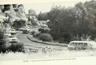
The opening the Twain Harte Grade portion of CA 108 bypassing Mono Vista and Hunts Camp is discussed in the January/February 1964 California Highways & Public Works. The Twain Harte Grade article goes onto details future development of CA 108 as far east as McCoy Saddle.
The November/December 1965 California Highways & Public Works cites the Twain Harte Bypass being extended easterly as an actively funded project.
The 1975 Caltrans State Map displays the planned bypass route for CA 108 around downtown Sonora.
Said CA 108 bypass route of downtown Sonora appears complete for the first time on the 1988 Caltrans State Map.
This illustration below shows what the alignment of CA 108 would have looked like before the bypass to the south was built. Mono Way was bypassed by a new expressway alignment of CA 108 in East Sonora circa 2014.
Part 2; a drive on California State Route 108
From US 395 southbound in Mono County traffic headed onto CA 108 west is advised if Sonora Pass is open. Traffic is also advised that vehicles over 38 feet in length are prohibited. Sonora is signed as 82 miles away on CA 108 west.
As CA 108 west begins traffic is immediately warned of the 26% grades five miles ahead approaching Sonora Pass.
Two miles into CA 108 west a truck turn around can be found.
At Postmile MON 12.96 CA 108 west crosses the West Walker River.
The CA 108 west truck route ends at the main gate of the Marine Corps Mountain Warfare Training Center at Postmile MON 11.08.
CA 108 traffic west of the Mountain Warfare Training Center is warned that snow is not removed ahead towards Sonora Pass. Further advisories denote the 38 foot length prohibition and twenty four miles of curves.
CA 108 west narrows and begins a steep ascent as it quickly climbs above 7,000 feet above sea level.
CA 108 west steepens and quickly ascends to 8,000 feet above sea level.
CA 108 west continues to ascend and crosses Sardine Creek at Postmile MON 3.05.
CA 108 west ascends to 9,000 feet above sea level.
CA 108 west makes a final climb to Sonora Pass at 9,624 feet above sea level. Sonora Pass serves as the Tuolumne County Line and boundary of Stanislaus National Forest.
The current CA 108/Sonora Pass Sign is made from vinyl and replaced a much more ornate Button-Copy Sign.
The Button Copy CA 108/Sonora Pass Sign as it was in 2016.
Sonora Pass intersects the Pacific Crest Trail.
As noted above the historic plaques for the Sonora-Mono Toll Road can be found at Sonora Pass.
Following the Pacific Crest Trail north from Sonora Pass provides an excellent eastward view of CA 108. The Pacific Crest Trail initially is a good analog for what the original Sonora-Mono Toll Road towards St. Mary's Pass was probably like.
CA 108 westbound begins a massive decent and drops below 7,000 feet above sea level from Sonora Pass via Deadman Creek en route to Kennedy Meadows Road. Kennedy Meadows Road is located at Postmile TUO 57.911.
CA 108 west passes by the site of Hayes Station in Kennedy Meadows. Hayes Station was built in 1860 in anticipation of the Sonora-Mono Toll Road being completed. Once the Sonora-Mono Toll Road was realigned onto Deadman Creek in 1865 Hayes Station became a resting point for numerous travelers crossing the Sierra Nevada Mountains.
CA 108 west from Hayes Station crosses the Middle Fork Stanislaus River at Postmile TUO 50.28.
CA 108 west levels out at the Middle Fork Stanislaus River at the community of Dardanelle located at approximately 5,800 feet above sea level. The 1933 Dardanelle's Bridge as noted above burned in 2018 and was located immediately north of modern CA 108. The 1933 Dardenelle's Bridge can be seen in the photos below from 2016.
At Postmile TUO 53.05 CA 108 west crosses Eagle Creek and passes by Dardanelle proper.
Sonora is signed 52 miles away from Dardanelle CA 108 west.
At approximately Postmile TUO 49.305 CA 108 west intersects Clarks Ford Road where it consolidates back in with the original route of the Sonora-Mono Toll Road. Sonora is signed as 48 miles to the west.
At Postmile TUO 46.413 CA 108 west intersects the Donnell Vista.
The Donnell Vista overlooks the Middle Fork Stanislaus River Watershed and has numerous informational displays on a short trail leading to the actual vista point.
From the Donnell Vista looking east on a clear day reveals a view of Sonora Pass.
CA 108 west of Donnell Vista hovers around 6,000 feet above sea level. At Postmile TUO 31.476 CA 108 west intersects the original Sonora Mono Toll Road alignment on Old Strawberry Road. At approximately Postmile TUO 31.25 CA 108 west passes through Strawberry and crosses the South Fork Stanislaus River.
At Postmile TUO 28.05 CA 108 west intersects the western terminus of Old Strawberry Road.
At Postmile TUO 27.093 CA 108 west passes through Cold Springs. The original Sonora-Mono Toll Road can be found on Old Mono Road in Cold Springs.
CA 108 west of Strawberry becomes a four lane expressway. At Postmile TUO R19.027 CA 108 intersects CA 108 Business on Long Barn Road (the original alignment of CA 108) in the community of Long Barn.
In Long Barn CA 108 west dips below 5,000 feet above sea level. Modesto appears as a control city for the first time and is signed as 68 miles away. West of Long Barn CA 108 leaves Stanislaus National Forest.
At Postmile TUO 16.607 CA 108 passes through he community of Sierra Village.
At Postmile TUO 15.514 CA 108 west passes through Mi-Wuk Village.
At Postmile TUO 13.35 CA 108 west passes through the community of Confidence.
At Postmile TUO R11.765 CA 108 west intersects it's original alignment on Twaine Hart Drive and Sign County Route E17 on Tuolumne Road.
CA 108 passes through the community of Mono Vista as a four lane expressway.
Approaching East Sonora CA 108 west becomes a Super Two Freeway. At Postmile TUO R2.224 CA 108 west intersects it's former alignment of Mono Way.
Modern CA 108 west bypasses downtown Sonora and meets CA 49 on the outskirts of the City.
Sonora lies at elevation of 1,796 feet above sea level. Sonora is the county seat of Tuolumne County which is one of the
original 1850 California Counties. Sonora was settled by Mexican miners
who named it after the Mexican State of the same name. Reportedly
Sonora once reached a population of approximately 14,000 residents at
the height of the Gold Rush boom. Sonora retains much of it's original
character and still boasts a population close to 5,000 people. This illustration below shows what the alignment of CA 108 would have looked like before the downtown bypass was built.
This is a quick visual look south on Washington Street from Stockton Street/CA 49. This view on Washington Street is where CA 108 eastbound originally began.
CA 108 west/CA 49 south enter the community of Jamestown. Traffic headed to Railtown 1897 Historic State Park is directed onto 5th Street.
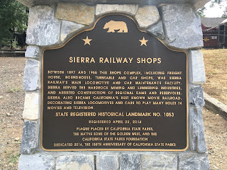
Railtown 1897 preserves a section of the narrow gauge Sierra Railroad
which operated until the 1960s by the West Side Lumber Company. The
State Historic Park features various real steam locomotive and a
functional locomotive repair shop. In 2018 I stopped at Railtown 1897
which is located on Sierra Avenue.
Railtown 1897 still features a working rail depot.
Sierra Railway #3 (the Back to the Future Part 3 train) can actually be taken on a 45 minute ride from the depot. Sierra Railway #3 is a steam locomotive constructed in 1891 and was retired from service in 1932. Sierra Railrway #3 was restored and put back into service at Railtown 1897 in 2010. The 45 minute ride on Sierra Railway #3 includes a decoupling, a couple mine overlooks, and an view of an old water tower siding.
Aside from Sierra Railway #3 the main attraction of Railtown 1897 is The
Roundhouse which is one of two remaining in the United States with it's
original tooling for steam locomotives. The Roundhouse contains
various locomotives and a working turntables.
The Blacksmith House is original and was used to construct tools for the Sierra Railroad.
The Lumber House features various signs and a timeline of what movies the Sierra Railroad appeared in.
More information can be found on the Railtown 1897 State Park website
Railtown 1897
At Route 49 Postmile TUO 14.797 CA 108 west/CA 49 south intersect their original alignment through Jamestown on Main Street.
The illustration below shows the difference between the original routing
of CA 49/108 versus the modern bypass.
Jamestown is named after Colonial George F. James who set out to stake
claims in the area following the discovery of gold at Sutter's Mill in
1848. Jamestown along Main Street largely appears much as it did during
the height of the California Gold Rush. Some of the notable structures
on Main Street at are; the 1898 Branch Jail, the 1897 Emporium, and the
1880 Jamestown Hotel.
At Route 49 Postmile TUO 14.748 CA 108 west/CA 49 south intersect Sign County Route E5 at Rawhide Road.
At Postmile TUO L2.804 CA 108 west splits from CA 49 south of Jamestown onto Frank F. Momyer Bypass.
CA 108 west of CA 49 intersects and begins to multiplex CA 120 west at Sonora Junction.
At Postmile Route 120 TUO 11.366 CA 108/CA 120 west intersect Sign County Route E15 at Obyrnes Ferry Road.
At Postmile Route 120 TUO 8.19 CA 108/CA 120 west intersect Sign County Route J59 at La Grange Road.
CA 108/CA 120 west of Sign County Route J59 expands to a four lane expressway. CA 108/CA 120 west drops back to a two lane highway at the Stanislaus County Line.
At Route 120 Postmile STA 17.06 CA 108/CA 120 intersects Sonora Road which serves as access to Knight's Ferry.
During 1848 near the beginning of the California Gold Rush
Knight's Ferry was established as a crossing of the Stanislaus River.
The ferry at Knight's Ferry was in operation only until 1852 when it was
replaced by a bridge. A second covered bridge was constructed in 1862
on higher grounds after a flood and was in operation until the 1980s
along Shuper Road. Knight's Ferry was the County Seat of Stanislaus
County from 1862 to 1871 when it was replaced by Modesto.
Unfortunately when I visited Knight's Ferry in 2016 I didn't have any cash on hand to go see the 1862 wooden
covered bridge but I was able to check out downtown along
Sonora Road. Sonora Road crosses the Stanislaus River on a modern
bridge and traffic is greeted by a large sign upon entering Knight's Ferry.
Knights Ferry has an old fire department building
along with a general store among many other structures that was worth
checking out on Sonora Road.
West of Knight's Ferry CA 108/CA 120 west drops to the Stanislaus River through the waning Sierra Nevada Mountain Foothills. CA 108/CA 120 west follows the Stanislaus River into Oakdale where they are aligned on F Street. CA 120 splits from CA 108 at Yosemite Avenue. CA 108 continues west from Yosemite Avenue on F Street. Note; Sign County Routes J9 and J14 are also aligned on Yosemite Avenue in downtown Oakdale.
CA 108 west follows F Street through to the City Limits of Oakdale. Riverbank is signed as 5 miles away on CA 108 west whereas Modesto is signed as 11 miles away.
CA 108 west follows the Stanislaus River into Riverbank. At Postmile STA 33.382 CA 108 west intersects Sign County Route J7 at Claus Road.
CA 108 west/Sign County Route J7 north follow Atchison Street through downtown Riverbank. Sign County Route J7 splits from CA 108 at 1st Street at Postmile STA 32.453.
CA 108 crosses the BNSF tracks via an overpass on Atchison Street to California Street.
CA 108 jogs right from California Street onto Patterson Road and leaves Riverbank.
At Postmile STA 29.134 CA 108 west turns southward onto McHenry Avenue towards Modesto. Note; Sign Country Route J6 begins on McHenry Avenue northward.
At Postmile STA 27.607 CA 108 west intersects CA 219 at Kiernan Avenue.
CA 108 west enters the City of Modesto on McHenry Avenue. At Postmile STA R23.079 CA 108 west makes a left hand turn onto Needham Street.
At Postmile STA R22.826L CA 108 west makes a left hand turn onto L Street.
CA 108 west follows a one-way alignment via L Street into downtown Modesto. At 9th Street CA 108 west ends at CA 132. Note; the route definition of CA 108 has it continue with CA 132 on L Street to CA 99 but there is no field signage indicating this is the case.












Comments
Long Barn is in Tuolumne County, not Tuolumne City, which was in Stanislaus County.
(The town in Tuolumne County is Tuolumne, just Tuolumne.)