This unique sign was present along 4th Avenue displayed a US Route 99 shield along with 1939 and 1940 Seattle traffic fatality statistics. A more conventional embossed US Route 99 shield can be seen on the left.
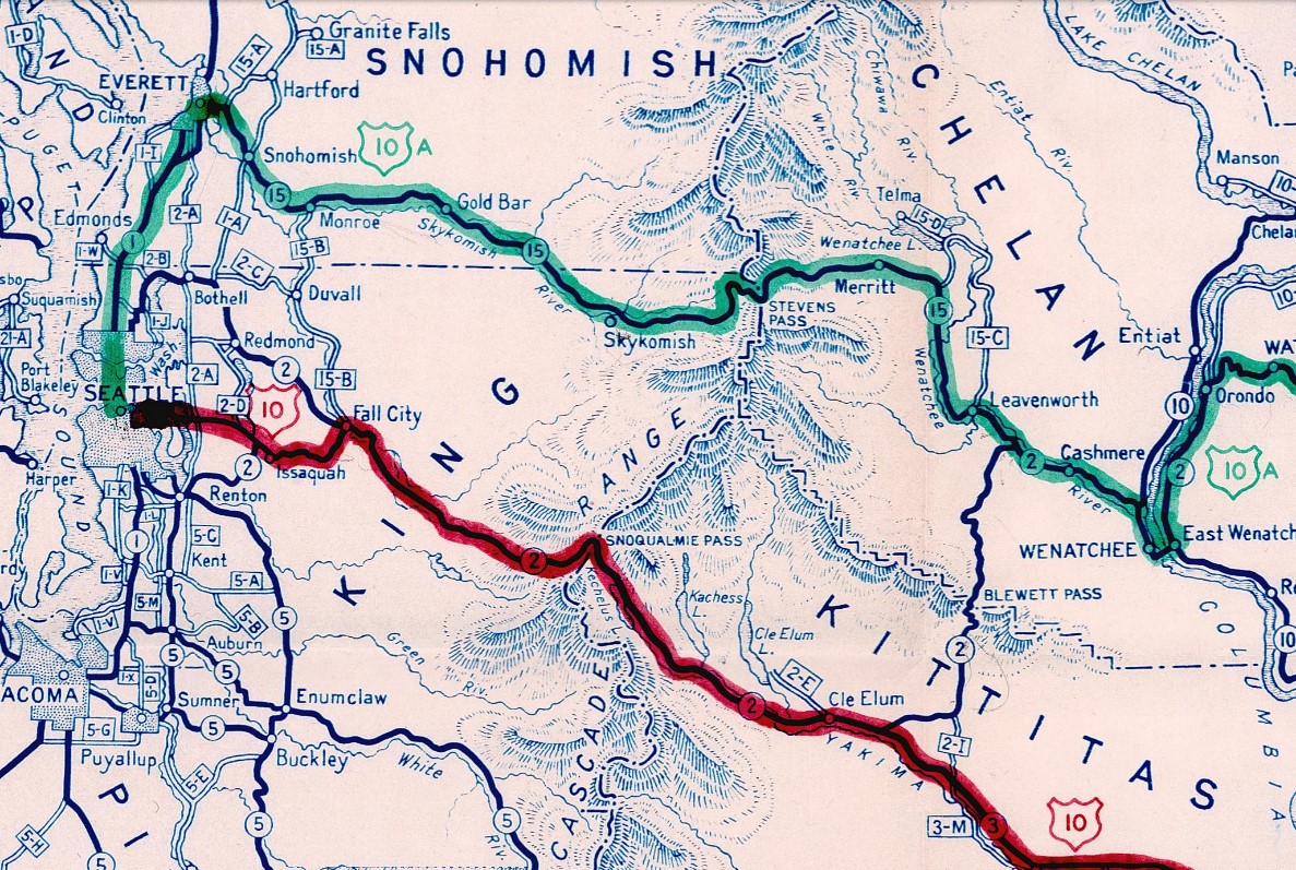
At the June 1940 AASHO Meeting the committee approved a northern alternate alignment for US Route 10. The northern alternate for US Route 10 crossed the Cascade Mountains via what was Washington State Road 15 over Stevens Pass to Everett. From Everett US Route 10 Alternate followed Hewitt Avenue, Broadway to US Route 99 at Everett Avenue. US Route 10 Alternate followed US Route 99 southbound from Everett into downtown Seattle where it met the mainline of US Route 10 at 4th Avenue and Dearborn Street. Originally the mainline of US Route 10 met US Route 99 via Jackson Street.
During the December 1946 AASHO Meeting the committee approved a request to extend US Route 2 from Bonners Ferry, Idaho to Everett. The extension of US Route 2 would replace US Route 10 Alternate over Stevens Pass and terminate at US Route 99 in Everett. US Route 10 Alternate was subsequently deleted following the extension of US Route 2.
The
April 10, 1910, Seattle Times reported on a city proposal by Gould & Champney to build an elevated roadway over what was then Railroad Avenue. The proposal had the elevated road reserved for automotive and pedestrian access whereas the lower parts would be reserved for freight. The concept was passed over. As noted in Part 1; Railroad Avenue would become Alaskan Way following completion of a seawall on the Seattle Waterfront in 1936.
During the 1930s through much of World War II there was an increasing series of complaints regarding traffic on Alaskan Way and US Route 99 in downtown Seattle. In 1945 as the war was drawing to a close the city of Seattle sought projects to earmark for near-future infrastructure improvements. A bypass routing for US Route 99 in downtown Seattle was studied during 1945 via provisions of the 1944 Federal Aid Highway Act. The study recommended the development of two freeways around downtown Seattle.
During
May 1947 representatives from Washington Department of Highways and United States Public Roads Administration met. It was during this meeting that the general design of the double-decker elevated Alaska Way Viaduct was finalized. These finalized plans were subsequently reviewed and approved by the Seattle city council during June 1947.
The Alaskan Way Viaduct was contentious politically for numerous reasons. The design included much debate of the placement of on/off ramps in the downtown area. Construction of the Alaskan Way Viaduct would ultimately break ground on
February 6, 1950. The initial segment of the project included the viaduct structure north of Pike Street and the Battery Street Tunnel to Aurora Avenue. This segment would open to traffic following a dedication ceremony held on April 4, 1953.
The below photo is from a ventilation test in the Battery Street Tunnel conducted on July 16, 1954 (Seattle Municipal Archives).
Initially traffic heading northbound could enter the Alaskan Way Viaduct could do so via Elliott Avenue. Southbound traffic branched from Aurora Avenue at the Battery Street Tunnel. Southbound traffic entered the Alaskan Way Viaduct at the southern tunnel portal and emptied onto city streets via 1st Avenue. This alignment is shown as part of US Route 99 Alternate on the
1954 Washington Department of Highways map. US Route 99 Alternate followed 1st Avenue south of the initial viaduct structure through downtown and merged into mainline US Route 99 at 4th Avenue via Marginal Way.
On June 29, 1956, the Federal Highway Aid Act of 1956 was signed into law on the Federal Level. The Federal Highway Aid Act of 1956 was the genesis point of the Interstate Highway System which would in the coming decade sew the demise via of US Route 99 in Washington via replacement by Interstate 5.
By 1956 a segment of the Alaskan Way Viaduct had been constructed in the vicinity of Connecticut Street (now Royal Brougham Way). The viaduct structure was built as far south as Holgate Street and continued at-grade to Hanford Street. These segments would open to traffic on September 3, 1959.
The nearly complete Alaskan Way Viaduct can be seen snaking along the Seattle Waterfront during February 1958 (Seattle Municipal Archives).
Following the completion of the Alaskan Way Viaduct the surface routing of US Route 99 in downtown Seattle was eliminated. US Route 99 Alternate was subsequently repurposed as the then new mainline highway. The
1962 Washington Department of Highways map depicts US Route 99 bypassing downtown Seattle via the Alaskan Way Viaduct.
Not all the planned ramps on the Alaskan Way Viaduct were ultimately constructed. The last to be built was the Columbia Street ramp. Said ramp had been funded by the Seattle city council during September 1964 and was opened to traffic on February 1, 1966.
On June 24, 1969, the AASHO Executive Commitee approved a request by the Washington State Highway Commission to eliminate US Route 99 in Washington. The Washington State Highway Commission approved a motion to eliminate US Route 99 on April 22, 1969. The justification to eliminate US Route 99 in Washington State was to avoid confusion and cost associated with signing the highway concurrent on much of Interstate 5.
The collapse of Interstate 880 on the Cypress Viaduct in Oakland, California during the 1989 Loma Prieta Earthquake led to concerns being raised about the seismic stability of the Alaskan Way Viaduct. Unlike the Cypress Viaduct the Alaskan Way Viaduct had been constructed in sections. This sectional design was thought to have been more resistant to earthquake damage.
As the Washington Office of Urban Mobility was preparing to study the Alaskan Way Viaduct the structure was impacted by the 6.8 magnitude Nisqually Earthquake on February 28, 2001. The structure was found to have shifted considerably and was subject to numerous closures while it was repaired. The viaduct was found to have subsided by 5.5 inches near Yesler Way during a 2009 engineering study.
Numerous options for replacing the Alaskan Way Viaduct were explored following the Nisqually Earthquake. This ultimately led into the Alaskan Way Viaduct replacement project which will be covered in Part 3 of this series:
Alaskan Way Viaduct Legacy Part 3; the Alaskan Way Viaduct replacement tunnel (coming soon).
Part 2B; exploring the Alaskan Way Viaduct
These photos of the Seattle Waterfront were taken by Gribblenation's Tom during May 2018. The Alaskan Way Viaduct is easily observed from the Bremerton-Seattle Ferry (Washington State Route 304).
This view is facing east towards the Alaskan Way Viaduct while departing the Bremerton-Seattle Ferry at Coleman Dock.
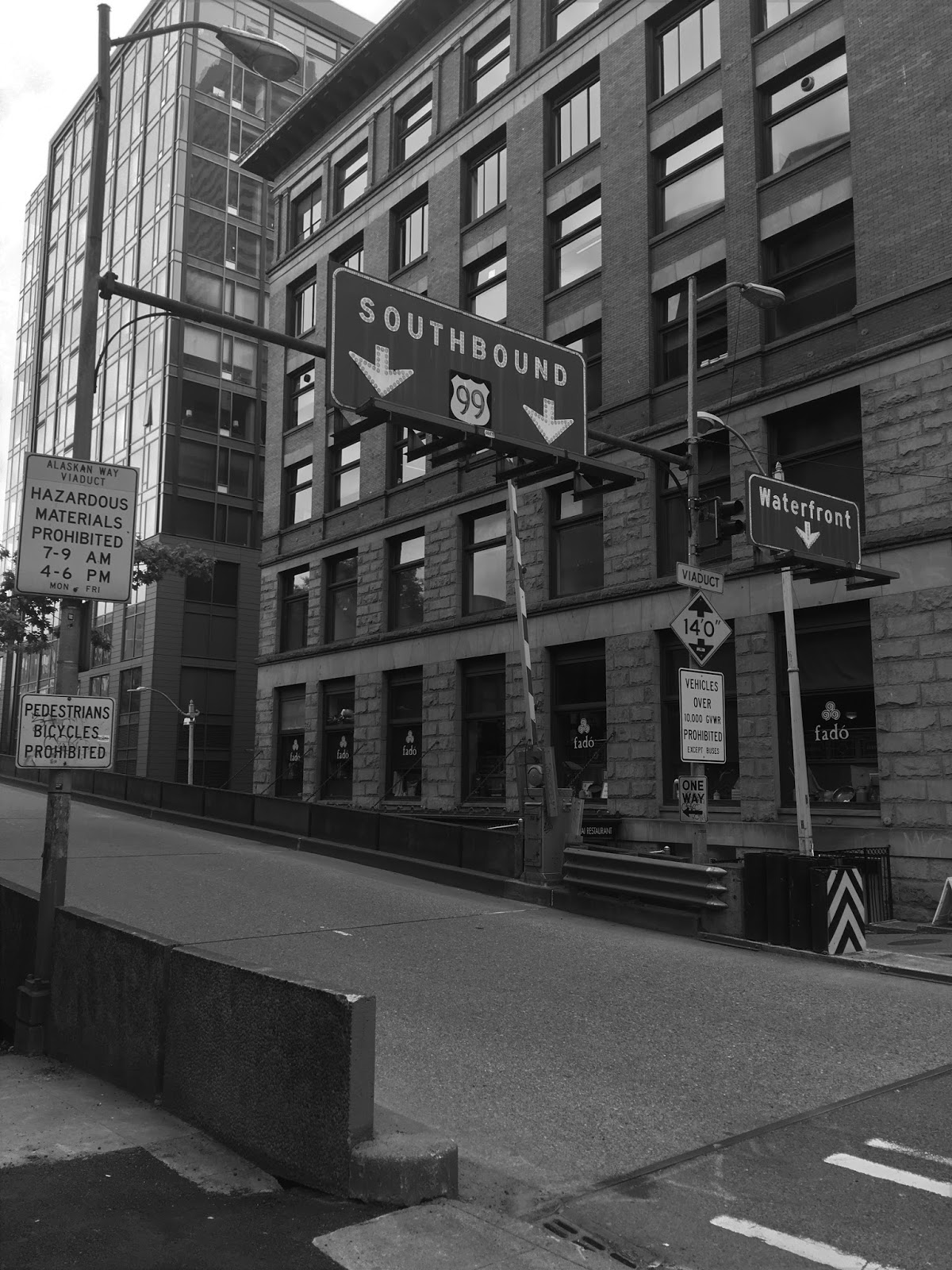
These photos are facing west towards the Columbia Street on-ramp to the Alaskan Way Viaduct. The last known US Route 99 shield in Washington can be seen on the overhead gantry.
These photos follow the final descent on Columbia Street to Alaskan Way. The substructure of the Alaskan Way Viaduct at the time covered Alaskan Way.
Facing towards Alaskan Way Viaduct from Union Street.
This view from 1st Avenue faces towards the Seneca Street exit from the Alaskan Way Viaduct.
The Alaskan Way Viaduct from the Harbor Step.
The Seneca Street exit from the Alaskan Way Viaduct.
These photos feature a drive on the southbound Alaskan Way Viaduct as it was in 2018. These photos were also taken by Gribblenation's Tom. Approaching the Battery Street tunnel on southbound Washington State Route 99 there was one final opportunity for traffic to exit into downtown onto Denny Way.
These photos are of the seawall present underneath Alaskan Way and the Alaskan Way Viaduct.


Comments