Undoubtedly the most scenic of the three National Parks in Florida is Dry Tortugas which I was able to visit in 2013 and 2014.

The Dry Tortugas are the western most seven Keys in the Florida Keys chain of islands. The Dry Tortugas are about 68 miles west of Key West and are about 2.5-3 hours away by catamaran from Key West Bight. Dry Tortugas National Park is known for Fort Jefferson located on Garden Key which also happens to be the largest masonry fort built by the United States.
A journey from Key West to Dry Tortugas via catamaran starts at the Key West Bight Terminal on Grinnell Street. In addition to the Dry Tortugas service there is also a ferry line to Fort Myers. There are some nice views of Trumbo Point, Mallory Square, Wisteria Island, and Tank Island pulling out of port.


Three to twelve miles west of Key West are the derelict Mule Keys. The Mule Keys aren't really all that different than the rest of the Florida Keys chain aside from being mostly uninhabited or off limits. In total there 12 named Mule Keys and Ballast Key is the only one that actually has a home on it.


About six miles west of the Mule Keys the Marquesas Key are separated by Boca Grande Channel. The Marquesas Keys are far less defined than the Mule Keys and generally have mangrove overgrowth connect much of the islets. There is a tiny harbor called Mooney Harbor nestled between all the mangrove overgrowth. The Marquesas Keys were once used for bombing runs out of the Avon Park Bombing Range.


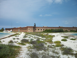
The Dry Tortugas are 36 miles west of the Marquesas Keys. There is a deep channel between the Marquesas Keys and Dry Tortugas which usually makes for rough sailing. Fort Jefferson is very apparent from a distance as the structure is rather large and tends to dominate the sight lines.

Although Fort Jefferson is on Garden Key it has largely merged together with nearby Bush Key and Long Key into one island. Access to Bush Key is off limits due to a bird nesting area.

Construction on Fort Jefferson began in 1846 and never really stopped until masonry forts were rendered obsolete during the Civil War. Fort Jefferson is surrounded by a large moat which separates it from the open waters.


The lighthouse on top of Fort Jefferson was built in 1877 to replace an earlier structure that dated back to 1824.
The interior of Fort Jefferson is massive with a double deck structure. My understanding is that the regular enlisted quarters were meant to be on the third level but were never completed. There is all sorts of ruins of officer housing and munition bunkers on the ground level of the fort. Dr. Samuel Mudd's prison cell which he was housed in following the Lincoln assassination from 1865 to 1867 is on the first level of the fort.


The second floor of Fort Jefferson has much more narrow brick openings than the first floor and has more narrow corridors.


The third level has unobstructed views of the Dry Tortugas Light on Loggerhead Key as well as high views of the fort structure. The Garden Key Lighthouse can be approached but is closed off.


The Dry Tortugas are the western most seven Keys in the Florida Keys chain of islands. The Dry Tortugas are about 68 miles west of Key West and are about 2.5-3 hours away by catamaran from Key West Bight. Dry Tortugas National Park is known for Fort Jefferson located on Garden Key which also happens to be the largest masonry fort built by the United States.
A journey from Key West to Dry Tortugas via catamaran starts at the Key West Bight Terminal on Grinnell Street. In addition to the Dry Tortugas service there is also a ferry line to Fort Myers. There are some nice views of Trumbo Point, Mallory Square, Wisteria Island, and Tank Island pulling out of port.


Three to twelve miles west of Key West are the derelict Mule Keys. The Mule Keys aren't really all that different than the rest of the Florida Keys chain aside from being mostly uninhabited or off limits. In total there 12 named Mule Keys and Ballast Key is the only one that actually has a home on it.


About six miles west of the Mule Keys the Marquesas Key are separated by Boca Grande Channel. The Marquesas Keys are far less defined than the Mule Keys and generally have mangrove overgrowth connect much of the islets. There is a tiny harbor called Mooney Harbor nestled between all the mangrove overgrowth. The Marquesas Keys were once used for bombing runs out of the Avon Park Bombing Range.


The Dry Tortugas are 36 miles west of the Marquesas Keys. There is a deep channel between the Marquesas Keys and Dry Tortugas which usually makes for rough sailing. Fort Jefferson is very apparent from a distance as the structure is rather large and tends to dominate the sight lines.

Although Fort Jefferson is on Garden Key it has largely merged together with nearby Bush Key and Long Key into one island. Access to Bush Key is off limits due to a bird nesting area.

Construction on Fort Jefferson began in 1846 and never really stopped until masonry forts were rendered obsolete during the Civil War. Fort Jefferson is surrounded by a large moat which separates it from the open waters.


The lighthouse on top of Fort Jefferson was built in 1877 to replace an earlier structure that dated back to 1824.

The interior of Fort Jefferson is massive with a double deck structure. My understanding is that the regular enlisted quarters were meant to be on the third level but were never completed. There is all sorts of ruins of officer housing and munition bunkers on the ground level of the fort. Dr. Samuel Mudd's prison cell which he was housed in following the Lincoln assassination from 1865 to 1867 is on the first level of the fort.


The second floor of Fort Jefferson has much more narrow brick openings than the first floor and has more narrow corridors.


The third level has unobstructed views of the Dry Tortugas Light on Loggerhead Key as well as high views of the fort structure. The Garden Key Lighthouse can be approached but is closed off.


Comments