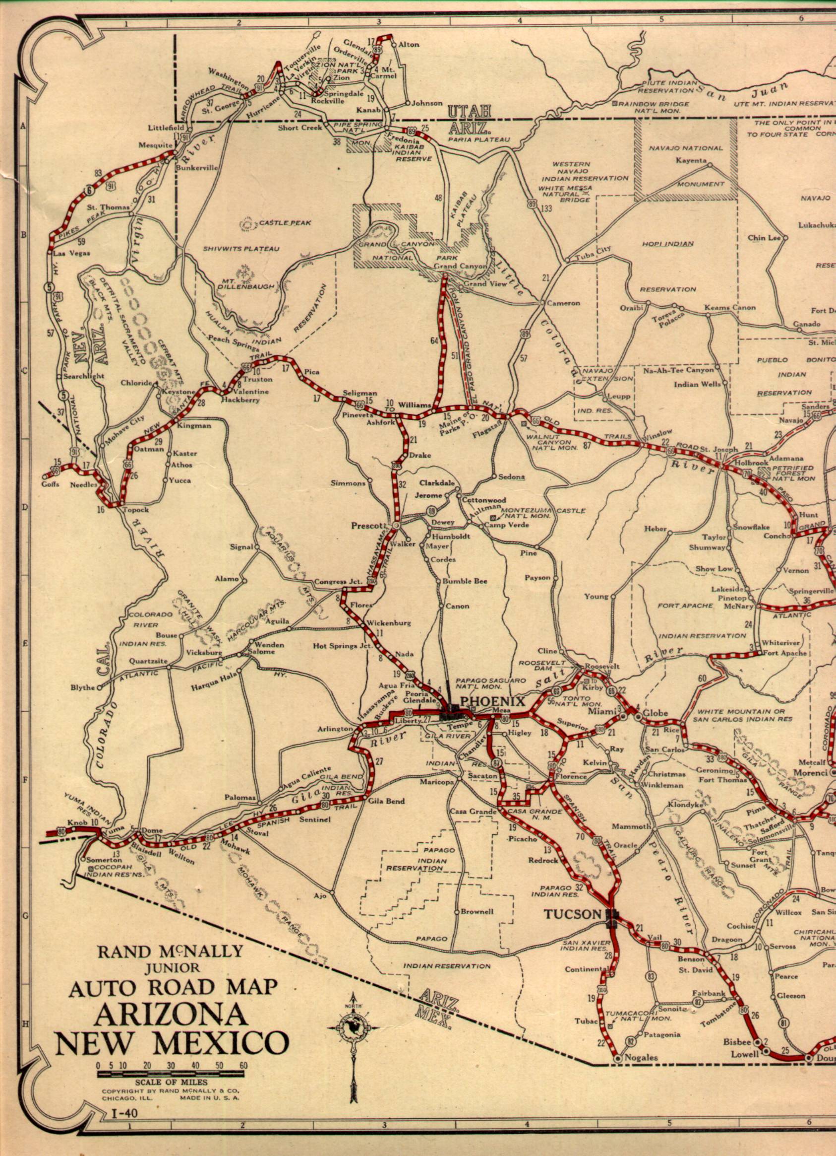
Continuing eastward from California, the Colorado River, and the Colorado River the course of US Route 66 entered Arizona. The more modernized alignment now occupied by I-40 traverses through Yucca to Kingman bypassing much of the Black Mountains. However, between 1926 to 1952 US 66 was aligned directly through the Black Mountains on what is known as Mojave County Route 10 or the Oatman Highway.

Back in circa late 2011/early 2012, I picked up Mohave County, Arizona, and Clark County, Nevada in my work territory. While working in Bullhead City I heard a tale of some crazy old alignment of US Route 66 up in the mountains which went through the ghost town of Oatman. One early morning I decided to go have a look and found one of the coolest little mountain towns in Arizona along with the infamous "Bloody 66" along the Oatman Highway over Sitgreaves Pass.
Early US Route 66 simply followed the previous alignment of the previous National Old Trails Highway between Los Angeles and Santa Fe with one major exception. The National Old Trails Highway was routed through Yucca whereas US Route 66 was routed through Oatman. Oatman at the turn of the 20th century was a prospering Gold Mining community with several small suburbs like Old Trails and Gold Road. Mining around Oatman began back when claims were staked in 1863 and by the early 20th century it had become a boom town. At one point Oatman had several thousand residents living in the canyons of the Black Mountains.
A fire burned down much of Oatman in 1921 and the biggest mining company the United Eastern Mines shuttered in 1924. According to conjecture I've heard over the years the road through Oatman was chosen for US Route 66 simply because of the money that was still there. I find that concept surprising given that by 1926 the major mining company in Oatman was gone. The remaining mines were shuttered in 1941 during World War II given that gold was deemed to be non-essential and much like Vulture City in Maricopa County the town of Oatman began to decline.
Unlike Vulture City, the town of Oatman was located US 66 which is likely the reason it never became completely abandoned. By 1953, US 66 was shifted through Yucca and Oatman began to rely on tourism to survive. Oatman today is filled with lots of well-cared-for old buildings, old highways, and even feral mining donkeys that come to pester tourists for food. The town of Oatman along with the Oatman Highway is an absolute blast and a must-see for anyone interested in history or anything road-related.
The 1927 State Highway Map of Arizona shows the alignment of US Route 66 through Oatman:
1927 Arizona State Highway Map
The map of Arizona in 1951 shows the last stand of the Oatman Highway as part of US 66:
1951 Arizona State Highway Map
The new and improved US 66 was routed through Yucca by 1953, the 1956 state highway map shows the alignment:
1956 Arizona State Highway Map
But what does the Oatman Highway look like? Access to the Colorado Arch Bridge is now cut-off by I-40. Traffic must exit off Interstate 40 and travel underneath the railroad tracks to rejoin the original alignment of US 66 on the Oatman Highway.

The Oatman Highway is a north/south road to Oatman and becomes east/west again from the top of Sitgreaves Pass. Entering Arizona the alignment of US 66 would have passed through the Topock Marsh along the Colorado River on the Oatman Highway.

In Topock/Golden Shores the Oatman Highway junctions Mohave County Route 1 and continues north. Topock dates back to the 1890s when it was a railroad stop that was built near the location of the Red Rock Rail Bridge which crossed the Colorado River. I'm not certain what the story with Golden Shores is, but I know it is a far more modern community that appears to be retiree oriented much like a large chunk of Mohave County.

Exiting Topock/Golden Shores the Oatman Highway becomes significantly more haggard as it approaches the peak known as the Boundary Cone. The Boundary Cone is a 3,432 peak in the Black Mountains which is easily observable from the California side of the Colorado River. My understanding is that the Boundary Cone was a religious site for several of the tribes along the Colorado River.


The Oatman Highway junctions Oatman Road/Mohave County Route 153 directly south of the town of Oatman. There are a couple decaying buildings south of the town near this sign which were actually part of the mining suburb Old Trails.

There isn't much parking in Oatman, really the best you get mid-day is an ungraded dirt lot. I tended to like to visit in the early mornings when the crowds weren't in town, there are plenty of weird little US 66 shields like the one painted on the road.

A look down the Oatman Highway in an early morning really illustrates how few people really live in Oatman these days. According to the 2000 census, there were just over 100 people left in Oatman, with most property owners living in Bullhead City. Oatman really tends to spring to life after 9 AM when all the shops start to open.


I always thought this wooden US 66 shield was amusing to look at.

I bought an Oatman Highway street blade last year, I am fairly certain it is the one in the above picture. The back side of the blade was black just like mine is.

I used to visit Oatman frequently, there are a ton of US Route 66 shields to be seen all over town. The Oatman Hotel actually dates back to 1902 and survived a fire in 1921.


It isn't uncommon to be mobbed by feral burros begging for food in Oatman. The burros are descendants of pack animals from when the mines in Oatman were abandoned in 1941. The burros typically stick close to Oatman but I've seen them as far south as AZ 95 just north of Lake Havasu City.


Continuing north on the Oatman Highway one of the original mine shafts can be toured on certain days.

The climb to Sitgraves Pass on the Oatman Highway is narrow and traverses the reactivated Gold Road Mine. Back in 2012, this section of the Oatman Highway had really active mine trucks which were ripping up the long decayed asphalt. The Oatman Highway was resurfaced over Sitgreaves Pass was repaved I believe back in late 2015.


Sitgreaves Pass is a 3,550-foot summit in the Black Mountains. The view of the Oatman Highway on both the east and west sides of the summit is really nice to look at. There used to be an ice cream shop at the top of Sitgreaves Pass and apparently back in the heyday of US 66 drivers could pay people to take them down to Oatman. Apparently driving the Oatman Highway was known for deadly wrecks and thus why it was often called "Bloody 66" much like La Bajada Hill in New Mexico was.


Descending the eastern slope of Sitgreaves Pass the Oatman Highway crosses Ed's Camp. Apparently, Ed's Camp is an old motor lodge where travelers would pay to sleep the night in their cars. I'm to understand that the camp is occupied and the owner doesn't take very kindly to people trespassing on his land. Apparently, the Cactus Cafe was named after two stray Saguaros which grew at Ed's Camp but are an overall rarity in the Black Mountains.


East of Ed's Camp is the Cool Springs Gas Station. Cool Springs was the site of an older gas station that underwent restoration a couple years ago. I don't have any photos from 2011 or 2012 so I substituted some from 2016 when I returned to the Oatman Highway with the Challenger.


The Oatman Highway continues eastward from Cool Springs before disappearing underneath I-40. From there traffic must either take I-40 or travel under the Interstate to reach Kingman.

Site Navigation:
Comments