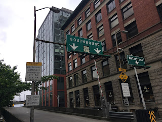
US Route 99


Welcome to the Gribblenation US Route 99 Page, your destination to find all things US Route 99.  US Route 99 was one of the original US Routes created in 1926 alongside the US Route System.  At its peak US Route 99 was approximately 1,600 miles spanning from Mexican Broder in Calexico, California north to the Canadian Border at Blaine, Washington.  US Route 99 has a legacy which is approached by few other American highways which has developed a strong following in the road community.  This page is meant to serve as compellation of all Gribblenation blogs and media pertaining to the US Route 99 family of highways.  

The page cover image seen above was taken from the Columbia Street onramp to former US Route 99 on the Alaskan Way Viaduct by Tom Fearer on May 10th, 2018.  Below the general corridor of US Route 99 as it was during its peak can be seen.  


A general timeline of the birth and death of US Route 99

The US Route System was finalized on November 11th, 1926 by the Executive Committee of the American Association of State Highway Officials ("AASHO").  US Route 99 was one of the original US Routes created by the AASHO Executive Committee.  As originally plotted US Route 99 began at US Route 80 in El Centro, California and terminated at the Canadian Border in Blaine, Washington.  The original southern terminus of US Route 99 in El Centro can be seen in the AASHO US Route descriptions for California dated November 11th, 1926.  


As originally conceived US Route 99 only had one three digit child route in the form of US Route 199.  US Route 199 was plotted via the Redwood Highway from Crescent City, California to Grants Pass, Oregon.  


On September 8th, 1931 the California Division of Highways proposed an extension of US Route 99 from US Route 80 in El Centro south to the Mexican Border at Calexico.  


The AASHO Executive Committee on June 22nd, 1932 notified the California Division of Highways that US Route 99 was approved to be extended to the Mexican Border.


On August 11th, 1934 the California State Highway Engineer petitioned the AASHO for a new US Route designation between Arcata and Alturas via the corridor of California State Route 44.  


The first route descriptions of US Route 299 and US Route 399 can be observed in a September 1934 letter by the California State Highway Engineer to the AASHO.  US Route 299 and US Route 399 along with numerous other US Route designations in California were approved by the AASHO Executive Committee Meeting during November of 1934.  US Route 299 retained the definition requested by the California Division of Highways for the Arcata-Alturas corridor.  US Route 399 is described as having a proposed length of 131 miles beginning from a south terminus at US 101 in Ventura along with a north terminus at US Route 99 in Bakersfield.


The elimination of US Route 299 was approved by the AASHO Executive Committee on June 19th, 1963 and would become effective on New Year's Day 1964.  The elimination of US Route 299 was requested by the State of California due to the highway not meeting the 1959 AASHO 300 mile intra-state standard for a single State US Routes.  The State of California intended to replace the entire 295 miles of US Route 299 with California State Route 299.  


On May 1st, 1963 the Division of Highways submitted a request to the AASHO Executive Committee to remove US Route 399 as part of the planned 1964 California State Highway Renumbering.   This request was considered by the AASHO Executive Committee on June 19th, 1963 and met with their approval.  US Route 399 subsequently would effectively cease to exist come New Year 1964.  US Route 399 was replaced by California State Route 119 from Bakersfield to Taft and saw California State Route 33 realigned from Maricopa via the Ventura-Maricopa Highway to Ventura.  


The truncation of US Route 99 from Calexico to the junction of the Golden State Freeway and San Bernardino Freeway in Los Angeles was approved by the AASHO Executive Committee on June 19th, 1963.  The justification by the California Division of Highways to truncate US Route 99 was to avoid what the agency viewed as confusing multiplexes on the new Interstate corridors of Southern California.  


The AASHO Renumbering database shows that US 99 was approved to be truncated out of California to Ashland, Oregon by the AASHO Executive Committee on June 29th, 1965.  This measure would have become effective on New Years Day 1966.  


On June 24th, 1969 the AASHO Executive Commitee approved a request by the Washington State Highway Commission to eliminate US Route 99 in Washington.  The Washington State Highway Commission approved a motion to eliminate US Route 99 on April 22nd, 1969.  The justification to eliminate US Route 99 in Washington State was to avoid confusion and cost associated with signing the highway concurrent on much of Interstate 5.  


On July 27th, 1971 the Oregon State Highway Division informed the AASHO Executive Director that the State Highway Commission had approved the elimination of US Route 99 from the State in favor of like numbered State Routes.


The elimination of US Route 99 from Oregon was approved by the AASHO Executive Committee on December 4th, 1971.  The deletion of US Route 99 in Oregon left only US Route 199 as the remaining part of the US Route 99 family left in the US Route System .


Version History of the Gribblenation US Route 99 Page

Version 1; page launched as of December, 13th 2021.  This page will be updated as blogs and media pertaining to US Route 99 are created.  Additional features may be added as this page progresses. 


Gribblenation blogs pertaining to US Route 99

The below directory is list of Gribblenation blogs pertaining to US Route 99.  This section will be updated from the most southerly location we have on file in California ascending northward towards the Canadian Border in Washington State.  Our blogs are heavily oriented towards exploring in detail the history of alignments of US Route 99 in particular regions and cities. 

US Route 99 in California


Oregon


Washington


Child Routes of US Route 99


British Columbia


Gribblenation Roadcast media 

The below directory is list of Gribblenation Roadcasts pertaining to US Route 99.  This segment will sporadically expand as topics of interest develop into Roadcasts. 


Comments

Unknown said…
Very interesting, I take both 99 E & W frequently from Portland South. There are a couple of spots near Jefferson Or that I am sure are part of 99E. I have also taken 99 south from Eugene until it runs into I 5. I am quite familiar with 99 after that.
I also know 199 very well. I was on 299 a few years ago at night. Never again at night.
Steve S. said…
That US 99 sign on the Alaskan Way Viaduct in Seattle was in place from its construction in 1953 until the viaduct was demolished in 2019 and probably was the last one extant. After US 99 was decommissioned in 1968 the road became WA 99. I5 was completed in Washington in 1970 I believe.

Popular posts from this blog

Cajon Pass; Cajon Pass Toll Road, National Old Trails Road, US Route 66/91/395 and Interstate 15

This past weekend I spent some time in Cajon Pass traversing the many historic road alignments. Cajon Pass is located in San Bernardino County, California along the San Andreas Fault.  Cajon Pass  serves the boundary line between the Mojave Desert, the San Gabriel Mountains, San Bernardino Mountains and San Bernardino Valley.  Cajon Pass is historically one of the most traveled transportation corridors in American California and presently is served by four rail lines, Interstate 15 and California State Route 138. While Cajon Pass is known mostly for carrying US Route 66 it has carried numerous other signed highways that have had a significant impact on regional and national road travel.  While this is my best attempt to compile everything from the best sources I could find into one single transportation history blog regarding road travel in Cajon Pass I suspect as time goes on this article will be frequently updated.  If you have any information that you ...

Pardee Dam Road

Pardee Dam is a 358-foot-high concrete structure located near Campo Seco at the Calaveras County and Amador County Line.  Pardee Dam impounds the Mokelumne River which forms the namesake Pardee Reservoir.  Pardee Dam was completed during 1929 and is part of the East Bay Municipal Utility District.  Pardee Dam is accessed by the namesake Pardee Dam Road which crosses the structure via the one-lane road seen as the blog cover photo.   Part 1; the history of Pardee Dam Road The closest community to Pardee Dam is that of Campo Seco on the Calaveras County side of the Mokelumne River.  Campo Seco was founded in 1850 by Mexican Miners who worked placer claims in Oregon Gulch during the height of the California Gold Rush.  Campo Seco would reach a population of about three hundred by 1860 spurred by the numerous mining claims in the area.  Main Street of Campo Seco flowed directly into the Campo Seco Turnpike which had been authorized by the California L...

California State Route 82/Old US Route 101 on the El Camino Real from San Francisco to Interstate 380

After completing Interstate 380 I made my way northward into the City Limits of San Francisco to drive the northernmost portion of California State Route 82. CA 82 is 52 mile State Route between I-280 in San Francisco southward to Interstate 880 in San Jose.  CA 82 is significant due to it being part of the historical surface alignment of US Route 101 and the El Camino Real. The "El Camino Real" was a Spanish Highway in Las Californias and Alta California which connected the 21 Catholic Missions along the coast.  Essentially the route of the El Camino Real was plotted out in the late 1700s from two Spanish survey expeditions.  The Missions were plotted approximately 30 miles apart along the 600 mile route so that they would be a single day journey by horse.  The El Camino Real name fell into disuse after the Mexican Revolution of 1821 but was revived by American highway promoters in the 1890s and 1900s.  Today the El Camino Real is mostly associated...