Former US Route 99 and US Route 50 within the City of Stockton occupied a corridor which largely was aligned on a multiplex east of downtown via Wilson Way. At the corner of Wilson Way and Doctor Martin Luther King Jr. Boulevard (formerly Charter Way) was once where US Route 99 and US Route 50 split. Stockton was also was part of the early US Route 99 East/West corridor and also was host to the earliest alignment of the Lincoln Highway.
This blog is part of the larger Gribblenation US Route 99 Page. For more information pertaining to the other various segments of US Route 99 and it's three-digit child routes check out the link the below.
Part 1; the history of the Lincoln Highway, US Route 99 and US Route 50 in Stockton
Stockton is one of the oldest cities in California and is the San Joaquin County Seat. The origins of Stockton date back to the late period of Mexican Alta California. In 1845 Captain Charles Maria Weber a German immigrant acquired Rancho Campo de los Franceses which was comprised of lands now occupied by modern day Stockton and French Camp. Weber was offered and declined a position in the Mexican Army as a cavalry captain when the Mexican-American War broke out in 1846. Weber at the time was living in San Jose and ultimately lost a great deal of trust with his Mexican business partners. Weber would subsequently sell all his business interests in San Jose in 1847 and move to his newly acquired lands on Rancho Campo de los Franceses.
Following the discovery of Gold at Sutter's Mill the lands of Rancho Campo de los Franceses began to see an influx of settlers landing via the San Joaquin River watershed through what came to be known as Stockton Slough. Weber attempted Gold mining but soon became more profitable at supplying the arriving miners. Weber set up the first permanent structure in what would become Stockton at what is known today as Weber's Point. The small community around Weber's Point would go by numerous names such as; Weberville, Fatville and California's Sunrise Seaport. In 1849 Weber laid out a town site known as Tulesburg but ultimately renamed it to Stockton in honor of United States Commodore Robert F. Stockton. Stockton was the first community in California to have an American name and would incorporate as a City on July 23rd, 1850.
Stockton would ultimately become the head of overland travel to Los Angeles via the Stockton-Los Angeles Road upon the beginning of the 1853 Kern River Gold Rush. The Stockton-Los Angeles Road was a replacement of the earlier El Camino Viejo which was aligned mostly through western San Joaquin Valley towards Corral Hollow Pass. Unlike the El Camino Viejo the Stockton-Los Angeles Road avoided the dense Tule Marshes of San Joaquin Valley. The Stockton-Los Angles Road stayed close to the Sierra Nevada Foothills southward from Stockton towards the new claims on the Kern River watershed.
From Stockton the path of the Stockton-Los Angeles Road traveled southeast to Heath & Emory's Ferry where it crossed the Stanislaus River into Stanislaus County. The Stockton-Los Angeles Road departing Stockton towards Stanislaus County can seen on the
1857 Britton & Rey's Map of California.
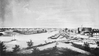
Stockton as it was in 1860 can be seen in this below public domain picture.
Stockton would begin to decline as a popular port in the later 19th Century but stayed relevant as a railroad corridor. The Western Pacific Railroad was completed in 1869 which connected Sacramento via Stockton and Altamont Pass to Alameda Terminal. The Western Pacific Railroad was absorbed by the Central Pacific Railroad in 1870 which annexed it into the First Transcontinental Railroad. The Central Pacific Railroad would begin construction of a line south from Stockton via Lathrop through San Joaquin Valley southward to Tehachapi Pass. The Central Pacific Railroad line south from Stockton to Tehachapi Pass would ultimately replace the Stockton-Los Angeles Road and push development of San Joaquin Valley. The development San Joaquin Valley was further enhanced when the Atchison, Topeka and Santa Fe Railroad was constructed from Stockton south to Bakersfield during the 1880s. Stockton can be seen along the Central Pacific Railroad on the
1873 Oregon, California, & Nevada Railroad Map.

The emergence of the automobile in the early 20th Century in California led to the 1909 First State Highway Bond Act which was approved by voters during 1910. The majority of the highways approved as part of the First State Highway Bond Act were largely well established routes of travel. One such highway was Legislative Route Number 4 ("LRN 4") which was defined as a highway from "Sacramento to Los Angeles."
During 1912 Indiana Businessman Carl G. Fisher conceptualized the Lincoln Highway as a major transcontinental Auto Trail. The Lincoln Highway was formally dedicated on October 31st, 1913 and would be aligned south from Sacramento southward towards Stockton via the existing highway corridor. From Galt the Lincoln Highway southwards followed existing LRN 4/Lower Sacramento Road through Woodbridge and Lodi onward into Stockton. The original alignment of the Lincoln Highway through Stockton followed; Pacific Avenue, Maple Street, El Dorado Street, Weber Avenue, Center Street and French Camp Parkway towards French Camp. This early alignment of the Lincoln Highway through Stockton can be seen on the Lincoln Highway Association's Official Map.
The planned route of LRN 4 can be seen on the on the 1917 California State Automobile Association Map. The planned route of LRN 4 (denoted as the red line) was conceived as a direct alignment from Galt to Lodi which would bypass Woodbridge. LRN 4 was planned to be realigned towards an eastern approach to Stockton via what is known Cherokee Road.
LRN 4 (then also known as the Inland Route) through Stockton is shown realigned onto the more direct routing from Lodi via what is now Cherokee Road on the 1920 Clason Highway Map of California. The Lincoln Highway is shown picking up a multiplex of the National Roosevelt Midland Trail from Waterloo Road southward to Lathrop. The Lincoln Highway Association notes this generation of the Lincoln Highway through Stockton as following; Cherokee Road, Waterloo Road, Wilson Way, Weber Avenue, Center Street and French Camp Turnpike.
The September 1924 California Highways & Public Works details the issues presented by upgrading LRN 4/Lincoln Highway between Sacramento and Stockton. A segment of oil bound macadam surface extending thirteen miles southward from Sacramento laid by Sacramento County in 1910 is cited as a problematic area. This segment of the Lincoln Highway was transferred to the State Highway System as part of LRN 4 during July of 1915 and had become functionally obsolete due to increasing traffic. The macadam surface is described as being replaced by a twenty foot wide Portland Cement surface.
The initial draft of the US Route System was approved by the Secretary of Agriculture during November of 1925. The US Route System within California was approved by California Highway Commission with no changes recommended by January 1926. The initial alignment of US Route 99 ("US 99") was planned to follow the Inland Route via LRN 4 from Sacramento to Los Angeles. US 99 is shown on a map published in the 1926 California Highways & Public Works following LRN 4 south from Sacramento through Stockton. Stockton is also listed as one of the principal cities along US 99.
The
May 1927 California Highways & Public Works notes a new alignment of US 99/LRN 4 over the Stockton Diverting Canal had been authorized for construction. The new bridge over Stockton Diverting Canal would serve as a new entrance for US 99/LRN 4 into the City of Stockton via an extension of Wilson Way.
The
May 1927 California Highways & Public Works announced the first Carquinez Bridge over Carquinez Strait near Vallejo had opened to traffic on May 21st. Upon completion of the Carquinez Bridge the Lincoln Highway was realigned out of Stockton and Altamont Pass onto the new structure multiplexed with the Pacific Highway. The realignment of the Lincoln Highway left US 99 as the primary highway corridor through Stockton.
The
June 1927 California Highways & Public Works announced the contract to construct the bridge over Stockton Diverting Canal had been awarded.


The
January/Febuary 1929 California Highways & Public Works announced the planned relocation of existing US 99/LRN 5 between Stockton and French Camp. A new grade intended to replace French Camp Turnpike south of Stockton is cited as being necessary due to the existing road being aligned over high dirt fill. The existing State Highway on French Camp Turnpike is stated to be planned for abandonment upon completion to the new grade of US 99/LRN 5. Note; LRN 4 had been relocated in 1928 from being aligned from Stockton towards Manteca via French Cram and Lathrop. The new alignment LRN 4 followed Mariposa Road and Hogan Road south from Wilson Way in Stockton on a more direct alignment towards Manteca.

The
December 1935 California Highways & Public Works announced $400,000 dollars in Federal WPA funds being dedicated as part of the project to construct the Charter Way Subway on US 50/LRN 5. A drawing of the planned Charter Way Subway is depicted along with numerous details about the project.
The
May 1937 California Highways & Public Works announced the opening of the Charter Way Subway on US 50/LRN 5. An opening ceremony dedicating the Charter Way Subway was held on May 8th, 1937. Previous to the opening of the Charter Way Subway US 50/LRN 5 had crossed eight sets of railroad tracks. A similar subway structure on US 99/US 50 on Wilson Way is stated to be going up for bid during May 1937.


The
February 1938 California Highways & Public Works announced $833,000 dollars had been earmarked for construction of four railroad subways. The Wilson Way Subway under the Atchison, Topeka & Santa Fe Railroad on US 99/US 50 in Stockton is listed as one of the four projects.
The
March 1938 California Highways & Public Works announced the opening of the Wilson Way Subway. The Wilson Way Subway was formally dedicated in an opening ceremony hosted by Governor Frank Merriam held on February 19th, 1938.
The
1938 Division of Highways Map City Insert is the first to show the Sign State Routes in Stockton in relation to US 99 and US 50 in detail. CA 4 is shown following the alignment described above and CA 8/LRN 5 is shown terminating at US 99/US 50 at the intersection of Wilson Way and Linden Road. US 99/US 50 on Wilson Way is shown intersecting LRN 97 at Cherokee Lane.
The
November/December 1946 California Highways & Public Works cites an ongoing project to convert 8.2 miles of US 99/US 50/LRN 4 between Stockton and Lodi as a limited access four lane freeway (which was in reality more in line with modern surface expressway standards). The freeway project is cited to originate at the Calaveras River four miles north of Stockton at the end of Wilson Way and included construction of two new concrete surfaced travel lanes.
The Stockton-Lodi Freeway is cited as being completed in the
July/August 1947 California Highways & Public Works. The Stockton-Lodi Freeway is cited to be a feature of the upcoming 1947 California State Fair. The article cites plans to convert US 99/LRN 4 to freeway from the Calaveras River south to Mariposa Road via a bypass of Stockton.
The
July/August 1949 California Highways & Public Works discusses the progress of the Stockton Bypass. Numerous contractors are cited to have completed grading and overhead structures on the Stockton Bypass by June of 1949. The Stockton Bypass project included an extension of Charter Way east from D Street which would also reroute US 50 off Wilson Way. A detailed map of the Stockton Bypass is displayed along with details pertaining the new freeway structures (note; again this is much closer in reality to a modern surface expressway).
The completed Stockton Bypass can be seen on the
1951 Division of Highways Map City Insert. US 99/US 50/LRN 4 are shown bypassing Wilson Way in favor of the Stockton Bypass. US 50/LRN 5 departs the US 99 and Stockton Bypass at Charter Way. CA 4 westbound is shown traversing northward from Farmington Road onto a multiplex of US 99/LRN 4 on the Stockton Bypass to Charter Way. CA 4 departs the Stockton Bypass at Charter Way where it began a multiplex through Stockton on US 50/LRN 5. Like the Stockton-Lodi Freeway the Stockton Bypass had occasional at-grade intersections.
The
July/August 1957 California Highways & Public Works details the planned freeway upgrade to US 50/LRN 5 from the San Joaquin River north to Richards Avenue in French Camp. This upgrade included an interim improvement which would expand US 50/LRN 5 to four lanes from French Camp to Charter Way in Stockton.
The
May/June 1958 California Highways & Public Works announced the US 99/LRN 4 Stockton Bypass had been picked up for full freeway conversion as part of a 1958 Federal Act Project. The project originated 0.2 miles south of Mariposa Road northward to Farmington Road and would include three interchange structures.
The same article notes US 99/LRN 4 on the Stockton Bypass between Mariposa Road and Farmington Road was planned to be completed to full freeway standards by August 1959.


The
1959 Division of Highways Map City Insert shows US 50/LRN 5 was split into one-way couplets immediately south of Charter Way. Eastbound US 50 reached Charter Way via El Dorado Street (formally McKinley Avenue) whereas westbound US 50 departed via Center Street.
The
September/October 1960 California Highways & Public Works announced the adoption of the planned alignment of Interstate 5 ("I-5") on the West Side Freeway. The adopted portion of the West Side Freeway extended 256 miles north from Wheeler Ridge towards Stockton as a western bypass. The West Side Freeway functionally was intended to replace US 50 from the outskirts of Tracy towards Stockton and supplement US 99 north of Wheeler Ridge. The West Side Freeway alignment north of Stockton to Sacramento is shown to be under study.
The
January/February 1961 California Highways & Public Works announced the completion of the Harding Way underpass on the Stockton Bypass. The Harding Way underpass was fully completed by August 25th, 1960 and provided a grade separation for US 99/US 50 under the Southern Pacific Railroad.
The Calaveras River-Lodi freeway segment of US 99/US 50/LRN 4 is cited in the November/December
1963 California Highways & Public Works as being completed during November 1963 alongside the Lodi Bypass Freeway.
The
January/February 1965 California Highways & Public Works discusses the ongoing progress towards completing US 99 to full freeway standards in San Joaquin County. Only two miles of US 99/US 50 in Stockton are cited as still being at expressway standards within the Stockton Bypass. These expressway segments of the Stockton Bypass are shown to be near Washington Avenue and Section Avenue. The article references the upcoming conversion of the remaining Stockton Bypass segments of US 99/US 50 to freeway standards in the near future.


The 1964 California State Highway Renumbering saw numerous US Routes eliminated to avoid numbering duplications of Interstates and long multiplexes. Given a large portion of US 99 was slated to be replaced with Interstate 5 it also was targeted for removal from California. The AASHO Renumbering database shows that US 99 was approved to be truncated out of California by the AASHO Executive Committee on June 29th, 1965. This measure was put Stockton on what is now California State Route 99 which would have become effective on New Years Day 1966.
The California Highways & Public Works publication ended in 1967 which makes tracing the exact date of the final freeway conversion of the Stockton Bypass difficult. The 1
967 Division of Highways Map shows US 50 and CA 99 multiplexing on the the fully freeway grade Stockton Bypass south from Lodi towards Charter Way. US 50 and CA 4 are shown multiplexing west on Charter Way towards El Dorado Street/Center Street.
Pertaining to the truncation of US 50; on April 13th, 1963 the Division of Highways petitioned the AASHO to scale the highway back from San Francisco to Sacramento due to it being multiplexed by numerous Interstate highways. The AASHO Executive Committee approved the truncation of US 50 to Sacramento during June of 1963 but it remained field signed into the early 1970s to San Francisco. US 50 was likely field signed to San Francisco due to the I-5/West Side Freeway segment not yet being completed.
According to CAhighways.org the
West Side Freeway segment of I-5 was completed to Sacramento by 1975. USends.com notes that field signage of
US 50 was scaled back from San Francisco to Sacramento likely by 1972. I-5 shows completed on the
1975 Caltrans State Highway Map City Insert with CA 4 being the stand alone route signed on Charter Way in Stockton. El Dorado Street south of Charter Way is shown to be relinquished from the State Highway System. Charter Way would remain part of CA 4 into the early 1990s when it was finally relinquished due to the Crosstown Freeway being completed between CA 99 and I-5.
Part 2; a drive on former US Route 99 and US Route 50 in Stockton
From current CA 99 northbound former US 99 can be accessed via Exit 252A onto Mariposa Road. Notably the current CA 99 freeway is aligned over what had been Hogan Road.
Former US 99 on Mariposa Road turns northwest and ends at Dr. Martin Luther King Jr. Boulevard (formerly Charter Way). Prior to the opening of the Stockton Bypass in 1950 former US 99 on Mariposa Road would have multiplexed CA 4.
Former US 99 northbound would have turned left at Charter Way westbound. After the Stockton Bypass opened in 1950 this segment would have been a multiplex of US 50 and CA 4. Former US 99 northbound would have turned right at Wilson Way. The intersection of Charter Way/Wilson Way was once the convergence point of US 99W/US 99E and later where US 99 would have met US 50.


Former US 99/US 50 on Wilson Way northbound crosses under the BNSF Railroad via the Wilson Way Subway.


Former US 99/US 50 northbound on Wilson Way intersects CA 4 and the Crosstown Freeway at Lafayette Street.
Former US 99/US 50 on Wilson Way continues northbound and intersects former CA 8 at Fremont Street (formerly Linden Road).
Former US 99/US 50 continues north on Wilson Way where it intersects Waterloo Road. Waterloo Road is where US 99 would have originally split towards Cherokee Road. Prior to the Stockton Bypass opening in 1950 US 99/US 50 would have intersected CA 88 at Waterloo Road.
North of Harding Way former US 99/US 50 begins to curve northeast towards Stockton Diverting Canal.
Former US 99/US 50 northbound on Wilson Way clambers over Stockton Diverting Canal.
Former US 99/US 50 on Wilson Way continues northward and merges in with the CA 99 freeway near the Calaveras River.
Further Reading
Continuing north on US Route 99 through Lodi, Galt and Elk Grove?
Continuing south on the original alignment of US Route 99 through French Camp to Mantaca?
Continuing south via the East/West split on US Route 99 towards Modesta via Manteca?


Comments