McFarland and Delano are cities located in northern Kern County, California which were on the original surface alignments of US Route 99. Within McFarland former US Route 99 is presently buried underneath the California State Route 99 freeway whereas in Delano it was aligned on High Street.
This blog is part of the larger Gribblenation US Route 99 Page. For more information pertaining to the other various segments of US Route 99 and it's three-digit child routes check out the link the below.
Part 1; the history of US Route 99 in McFarland and Delano
Both McFarland and Delano are located on what was the Southern Pacific Railroad (presently Union Pacific Railroad) in southern San Joaquin Valley. When the Southern Pacific was building it's line through San Joaquin Valley towards Tehachapi Pass it plotted Delano as one of it's sidings. Delano was formally plotted out on July 14th, 1873 when it was at the temporary southern terminus of the Southern Pacific Railroad line through San Joaquin Valley. Delano was named in honor of then U.S. Secretary of the Interior Columbus Delano. Post Office Service was established in Delano in 1874 and it would incorporate as a City on April 13th, 1915. Delano can be seen on the 1876 Holt Map of California and Nevada along the Southern Pacific Railroad.

McFarland was plotted out in 1907 when James Boyd-McFarland purchased Hunt's Siding which was located on the western flank of the Southern Pacific Railroad. Post Office Service in McFarland would be established in 1908 but a town site would not be formally plotted until 1909. McFarland would incorporate as a City on July 18th, 1957.
The emergence of the automobile in the early 20th Century in California led to the 1909 First State Highway Bond Act which was approved by voters during 1910. The majority of the highways approved as part of the First State Highway Bond Act were largely well established routes of travel. One such highway was Legislative Route Number 4 ("LRN 4") which was defined as a highway from "Sacramento to Los Angeles."
A very early LRN 4 in northern Kern County can be seen on the 1917 California State Automobile Association Map. The California State Automobile Association Map show LRN 4 unconstructed via a plotted line (highlighted in red) along the Southern Pacific Railroad between Earlimart of Tulare County south to Delano. LRN 4 is shown following High Street through downtown Delano southward towards McFarland. The pre-existing right-of-way between Earlimart and Delano appears to follow modern Armstrong Avenue, Road 144 and Girard Street.
LRN 4 through Delano and McFarland can be seen signed as the Inland Route and National Park-to-Park Highway on the 1920 Clason Highway Map of California. The Clason Highway Map shows a realigned direct route of LRN 4 following the Southern Pacific Railroad from the Tulare County Line to Delano.
The initial draft of the US Route System was approved by the Secretary of Agriculture during November of 1925. The US Route System within California was approved by California Highway Commission with no changes recommended by January 1926. The initial alignment of US Route 99 ("US 99") was planned to follow the Inland Route via LRN 4 from Sacramento to Los Angeles. US 99 is shown on a map published in the 1926 California Highways & Public Works following LRN 4 south from Sacramento through Delano and McFarland.
The
1935 Division of Highways Map of Kern County depicts how early US 99/LRN 4 was aligned on High Street through downtown Delano and crossed the Southern Pacific Railroad via a surface level overpass. McFarland can be seen centered immediately west of US 99/LRN 4.
The August 1936 California Highways & Public Works discusses the opening of the "Delano Underpass" realignment of US 99/LRN 4 in Delano. The Delano Underpass is described as a 0.97 mile realignment of High Street which carried four ten foot lanes of US 99/LRN 4. The previous overpass alignment of US 99/LRN 4 via High Street was considered one of the most dangerous in San Joaquin Valley.
The
September 1950 California Highways & Public Works announced US 99/LRN 4 through McFarland was expanded to divided expressway standards. This expressway upgrade of US 99/LRN 4 through McFarland essentially served to bisect the community even though it was originally centered west of the Southern Pacific Railroad.
The
September/October 1954 California Highways & Public Works announced that a freeway bypass of Delano was in the process of construction. This freeway bypass would see US 99/LRN 4 realigned off of High Street and would serve as extension of the existing divided highway originating from Los Angeles.
The
July/August 1956 California Highways & Public Works announced the Delano Bypass Freeway realignment of US 99/LRN 4 was complete. The Delano Bypass Freeway opened to traffic on June 22nd, 1956 between one half mile south of the Delano Underpass northward to the Tulare County Line. The City of Delano had signed an agreement with the Division of Highways to construct a freeway bypass during 1952. A key feature of the Delano Bypass Freeway was the Delano Overhead which crossed the Southern Pacific Railroad and High Street.
The
September/October 1958 California Highways & Public Works article pertaining to Tipton of Tulare County referenced US 99/LRN 4 as having been upgraded to freeway standards in the City of McFarland. The overhead structures in McFarland are not covered in any California Highways & Public Works but all carry build date stamps of 1957.
The 1964 California State Highway Renumbering saw numerous US Routes eliminated to avoid numbering duplications of Interstates and long multiplexes. Given a large portion of US 99 was slated to be replaced with Interstate 5 it also was targeted for removal from California. The AASHO Renumbering database shows that US 99 was approved to be truncated out of California by the AASHO Executive Committee on June 29th, 1965. This measure was put Delano and McFarland on what is now California State Route 99 "CA 99."
Part 2; former US Route 99/current California State Route 99 in McFarland
North of Exit 47 CA 99 enters the City of McFarland. The Union Pacific Railroad is surprisingly close to the northbound lanes of CA 99 in McFarland. The close proximity of CA 99 to the Union Pacific serves as trace evidence of the highway never has moved from the rail reservation in McFarland.
CA 99 northbound Exit 49 accesses Sherwood Avenue in McFarland.
CA 99 north of Sherwood Avenue crosses under a pedestrian overpass. This photo is shown from 2014 but the overpass structure now is adorned with silhouettes of runners. The runner silhouettes are a reference to the 2015 movie McFarland USA which featured the story of the successful McFarland High School cross-country team.
CA 99 northbound Exit 50 accesses Elmo Highway and Perkins Avenue before departing McFarland.
Part 3; former US Route 99 on High Street in Delano
Approaching the City of Delano CA 99 northbound Exit 54 can be used to access former US 99 on High Street.
Former US 99 on northbound High Street crosses Woolhomes Avenue and approaches the Delano Underpass.
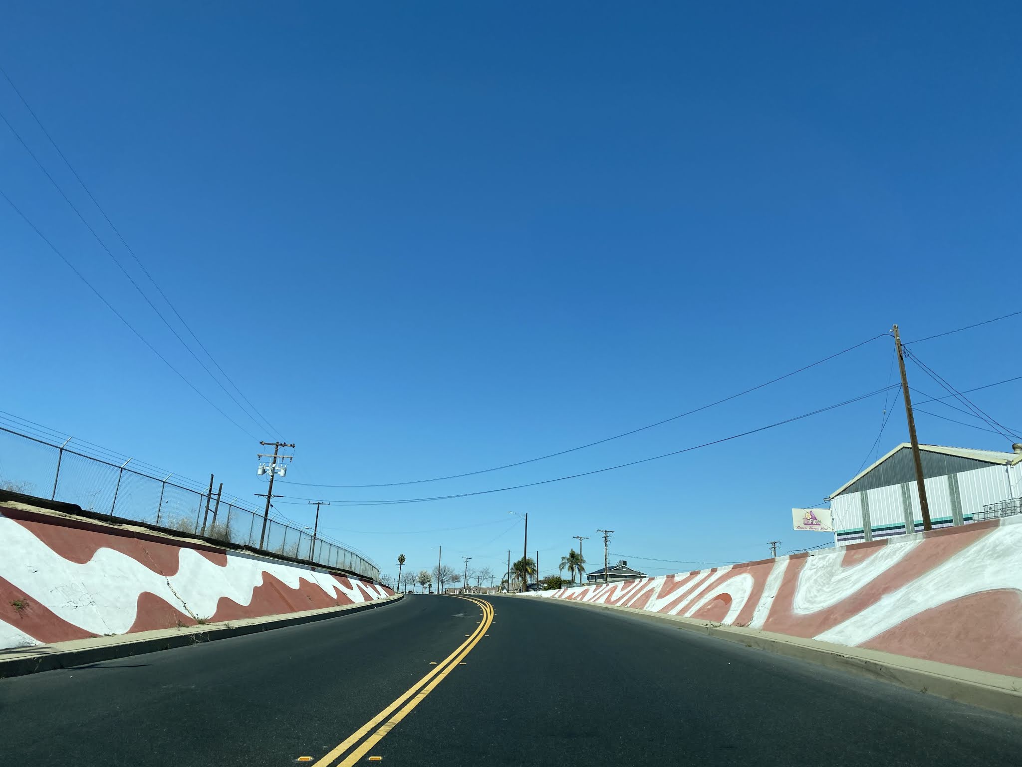
Former US 99 on northbound High Street crosses through the Delano Underpass and enters downtown Delano. The original S-Curve overpass approach which carried US 99/LRN 4 over the Southern Pacific Railroad can be spied behind the Delano Veterinary Hospital (Photo 1 below). The Delano Underpass has been painted with the pattern of an American Flag. From modern convention it is hard to envision the Delano Underpass carrying four lanes of traffic.
Former US 99 northbound on High Street intersects CA 155 at Garces Highway.
Former US 99 northbound on High Street passes through downtown Delano. Access to the CA 99 Freeway can be found departing downtown Delano at Cecil Avenue.
Approaching the Delano Overhead former US 99 on High Street intersects Girard Street.
Former US 99 on northbound High Street crosses under the Delano Overhead. High Street terminates at the CA 99 freeway just north of County Line Road.
Further Reading
Continuing north on US Route 99 to Earlimart and Pixley?
Continuing south on US Route 99 to Famoso?


Comments