

Part 1; the history of US Route 99 in Modesto
Modesto was settled as a siding of the Southern Pacific Railroad in 1870. Modesto was originally slated to be named "Ralston" in honor of financier William C. Ralston. Ralston requested to have another name for the siding to be found. The name "Modesto" was chosen to recognize the modesty of Ralston. The construction of the Southern Pacific Railroad in San Joaquin Valley brought a large of amount of commerce as the previous transportation corridors in the Sierra Nevada Foothills were rendered obsolete. Modesto grew rapidly and replaced Knight's Ferry as the Stanislaus County Seat in 1872. Modesto can be seen along the Southern Pacific Railroad on the 1873 Oregon, California, & Nevada Railroad Map.

The Southern Pacific Railroad also laid out a road network which served as a frontage facility. The ease of using the Southern Pacific in addition to it's frontage road rendered the Stockton-Los Angeles Road functionally obsolete to anything other than localized travel. As part of the outgrowth of the Southern Pacific a bridge was built across the Tuolumne River via what is now 7th Street. The original 7th Bridge can be seen on the photo sourced from Bridgehunter.com. A full link to the original 7th Street Bridge can be found here.

Within San Joaquin Valley much of LRN 4 incorporated what was the
Southern Pacific Railroad frontage roads. A very early LRN 4 in Modesto can be seen on the 1917 California State Automobile Association Map. Early LRN 4 southbound through Modesto can be seen utilizing; 9th Street, I Street, 7th Street over the Tuolumne River, and Hatch Road.
As part of the construction of LRN 4 a new 7th Street Bridge was constructed in 1916 across the Tuolumne River. The original 7th Street Bridge was a Pennsylvania Truss span whereas the 1916 replacement was an experimental Steel Truss-Closed Spandrel Concrete Deck Arch. The 1916 7th Street Bridge was adorned on both approaches with dual statutes of lions which led some to call it the "Lion Bridge." The 1916 7th Street Bridge can be seen in the photo below during 1920 sourced from historicbridges.org. A full link which has numerous early pictures of the 1916 7th Street Bridge can be found here.

LRN 4 in Modesto can be seen on the 1920 Clason Highway Map of California as part of the Inland Route and Midland Trail.

The initial draft of the US Route System was approved by the Secretary
of Agriculture during November of 1925. The US Route System with in
California was approved by California Highway Commission with no changes
recommended by January 1926.
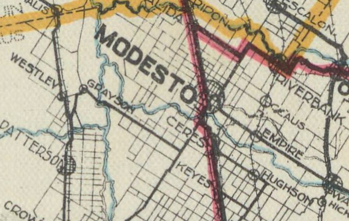
The initial alignment of US 99 was largely planned to follow LRN 4 through San Joaquin Valley which included the City of Modesto. US 99 is shown on a map
published in the 1926 California Highways & Public Works following LRN 4 through Modesto.


Thusly US 99 appears on the 1925 Rand McNally Map of California as being routed through Modesto on LRN 4.

During November of 1926 the US Route System was approved by the AASHO.
US 99 can be seen aligned on LRN 4 through Modesto on the 1927 National Map Company Sectional Map.

US 99 through the late 1920s and early 1930s quickly saw a massive increase of traffic. Said increase in traffic rendered much of US 99 on LRN 4 functionally obsolete, including the 7th Street Bridge. The September/October 1932 California Highways & Public Works discusses a replacement span to the 7th Street Bridge over the Tuolumne River being advanced for contract bid in Nov 1932. The new bridge is cited to have a 50-span Steel Girder/Concrete Deck design.


The November/December 1932 California Highways & Public Works elaborates on the replacement project for the 7th Street Bridge. The new bridge over the Tuolumne River would include a realigned US 99/LRN 4 which would eliminate two at-grade rail crossings.


The completion of the new bridge over the Tuolumne River is discussed in the July/August 1933 California Highways & Public Works. The new alignment of US 99/LRN 4 diverged from the original highway via an extension of 9th Street from I Street southward towards Hatch Road. This effectively streamlined US 99/LRN 4 south of downtown Modesto which in the process removed rail crossings on I Street and Hatch Road. The new alignment of US 99/LRN 4 over the Tuolumne River via the 9th Street extension opened on July 4th, 1933.


The original alignment of US 99 via the 7th Street Bridge compared to the July 1933 realignment via the 9th Street extension can be seen on this custom map below.

US 99/LRN 4 through Modesto on the 9th Street Extension can be seen on the 1935 California Division of Highways Map of Stanislaus County.

The October/November 1954 California Highways & Public Works briefly mentions that a new freeway alignment US 99/LRN 4 was being considered by the California Highway Commission through the City of the Modesto.

The July/August 1959 California Highways & Public Works cites a District 10 report which states that an agreement had been reached with the City of Modesto to construct a freeway alignment of US 99/LRN 4.


US 99 during the 1964 State Highway Renumbering was Legislatively truncated from Red Bluff south to Wheeler Ridge as much of its mileage was assigned to Route 5 in anticipation of Interstate 5 being built. This effectively would put Modesto on what would become California State Route 99 ("CA 99") the description of which can be seen on the 1964 Division of Highways State Map.


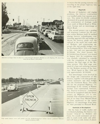
The November/December 1964 California Highways & Public Works announced that the new US 99 freeway through Ceres-Modesto was anticipated to be completed by Spring 1965.


The September/October 1965 California Highways & Public Works discusses the opening of the Modesto Freeway alignment of US 99. The Modesto Freeway was opened to traffic on June 30th, 1965.


US 99 is shown replaced by CA 99 through Modesto on the 1967 Division of Highways State Map.

Part 2; the doom of the 7th Street Bridge
Despite US 99 having been long realigned off of the 7th Street Bridge the structure persisted as a locally controlled road. According to a November 7th, 2019 report by Modesto ABC 10 the 7th Street Bridge first saw weight restrictions enacted in 1937. The 7th Street Bridge weight limit was cited to have dropped to 4 tons by 1979 relegating it use by nothing heavier than a light truck. The 7th Street Bridge was deemed to have been beyond repair due to the experimental Steel Truss-Closed Spandrel Concrete Deck Arch. The design of the 7th Street Bridge covered it's steel skeleton which means that entire concrete facade would need to be removed to save it. It was estimated that 80-100 overweight trucks crossed the 7th Street Bridge in 2018 which led to the Stanislaus County Deport of Public Works temporarily reinforcing it with wooden planks.

A piece of steel reinforcement can be seen propping up a partially crushed/sagging arch on the northern parts of the 7th Street Bridge.

7thstreetbridge.org is jointly managed by the City of Modesto and Stanislaus County. The website details the current progress towards replacing and demolishing the 7th Street Bridge. The 7th Street Bridge is cited to have a sufficiency rating presently of "2" which makes it among the worst rated in California. Presently the 7th Street Bridge replacement project is Phase 1/Right of Way Coordination which is slated to continue to October 2022. At the moment Phase 7/construction is slated to begin in either 2023 or 2024.

The 7th Street Bridge project description can be seen below.

Below are the current drawings on file for the 7th Street Bridge project.


Part 3; a visit to the 7th Street Bridge
Given that the 7th Street Bridge is literally on it's last legs it became a priority for me to visit to document the original alignment of US 99 through Modesto. I approached the 7th Street Bridge from northbound 7th Street. I made a detour down to River Road to check out the substructure of the 7th Street Bridge. The 4 ton/trucks prohibited sign approaching the 7th Street Bridge can be seen at the River Road turn off.


The Lion statues can be seen below the 7th Street Bridge approaching River Road.

Finding a shoulder on River Road to check out the substructure of the 7th Street Bridge was difficult due to the recently installed Jersey Barriers.


Unlike the photos shown above of the braced northern parts of the 7th Street Bridge the southern parts of the structure are in far better shape. Note; the 7th Street Bridge is 1,170 feet in length.

I crossed the 7th Street Bridge northbound towards B Street.


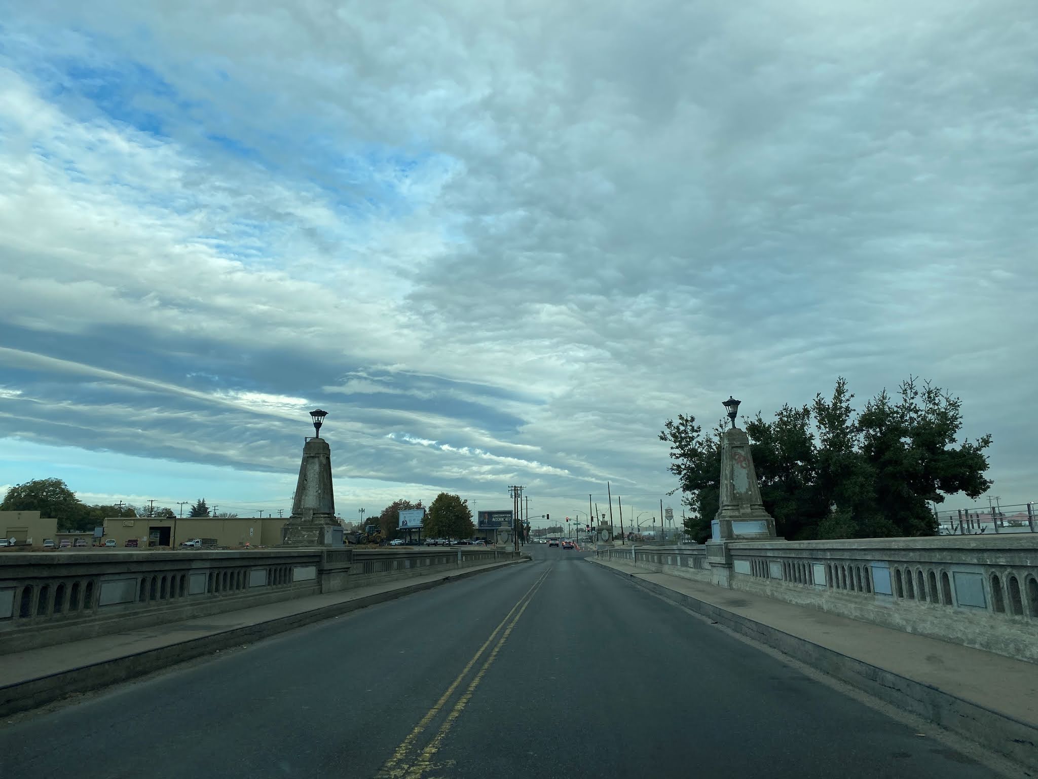

I turned around and crossed the 7th Street Bridge southbound to River Road. Regardless of the sad state of the 7th Street Bridge it is even sadder to fathom another historic segment of US Route 99 disappearing.


A badly misaligned segment of the 7th Street Bridge can be seen from the road deck approaching River Road.


Part 4; a drive on former US Route 99 on the 9th Street extension
My approach to former US 99 on the 9th Street Extension was from northbound CA 99 Exit 224.


Former US 99 northbound on 9th Street approached the Tuolumne River near the River Road intersection.


Former US 99 on 9th Street crosses the 2004 Tuolumne River Bridge into the City of Modesto. The 2004 Tuolumne River Bridge carries a design which emulates the 1933 structure it replaced.


As former US 99 on 9th Street enters downtown Modesto it picks up present California State Route 132 ("CA 132") at D Street.

Former US 99/Current CA 132 west pick up the original alignment of US 99 at I Street. The I Street Arch can be seen in the fourth photo below. The I Street Arch was built in 1912 during the early days of LRN 4.


As former US 99/current CA 132 west on 9th Street approaches J Street the 1915 Southern Pacific Depot can be found. The 1915 Southern Pacific Depot no longer serves passenger traffic but
is now the bus depot for the City of Modesto. Passenger service in
Modesto is accessed via the BNSF line on the eastern outskirts of the
City.


At K Street former US 99/current CA 132 west on 9th Street intersect CA 108 eastbound.


At L Street former US 99 continues north on 9th Street whereas CA 132 splits west towards Tracy. the eastern intersection of 9th Street and L Street serves as the west terminus of CA 108.


Former US 99 on 9th Street north of downtown Modesto where it crosses under Beech Street, crosses under current CA 99, and is cut-off at Carpenter Road.


Comments