
This past weekend I explored the alignments of US Route 99, US Route 466, and California State Highway 65 through Famoso.
This blog is part of the larger Gribblenation US Route 99 Page. For more information pertaining to the other various segments of US Route 99 and it's three-digit child routes check out the link the below.

Part 1; The history of State Highway service in Famoso
Famoso is a ghost town and former Southern Pacific Railroad siding located in northern Kern County on Poso Creek. The site of Famoso is located roughly at the junction of CA 99 and CA 46. Famoso was founded as a Southern Pacific Railroad siding known as "Poso" during the early 1870s when the Southern Pacific Railroad was building it's main freight line through San Joaquin Valley. The name of Poso was changed in 1888 to Spottiswood when the community received a spur line of the Southern Pacific and Post Office Service. The community name of Poso was already in use by a mining community to the west in San Luis Obispo County which required a new name be chosen to establish Post Office Service. The name of Spottiswood was changed to Famoso in 1895.
Famoso was an important early highway junction in San Joaquin Valley. The alignment of Legislative Route Number 4 ("LRN 4") was plotted through Famoso via Famoso-Porterville Highway and C Street when it was established in 1910 when the 1909 First State Highway Bond Act was approved. The early alignment LRN 4 required north/south traffic to cross the Southern Pacific Main Freight Line twice in Famoso.
A new east/west State Highway was added to Famoso in the form of LRN 33 which was approved during the 1916 Second State Highway Bond Act. LRN 33 had an eastern terminus in Famoso which entered the community via; Paso Robles Highway, crossed the Southern Pacific Main Freight Line, and terminated LRN 4 via Famoso Road.
During the era of the Auto Trail the alignment of LRN 4 through Famoso carried numerous highway designations. The National-Park-to-Park Highway, Inland Route, and the National Roosevelt Midland Trail can all be seen on LRN 4 through Famoso on the 1920 Clason Highway Map of California below.

In November of 1926 the US Route System was approved. US Route 99 in turn was added to LRN 4 which put it on C Street and Famoso-Porterville Highway in Famoso. US Route 99 can be seen aligned through Famoso on the 1927 National Map Company Highway Map of California.

In 1929 LRN 129 was added to the State Highway System between "near Bakersfield" and General Grant National Park. The original southern terminus of LRN 129 met US 99/LRN 4 in Delano which can be seen on the 1930 Division of Highways State Map.
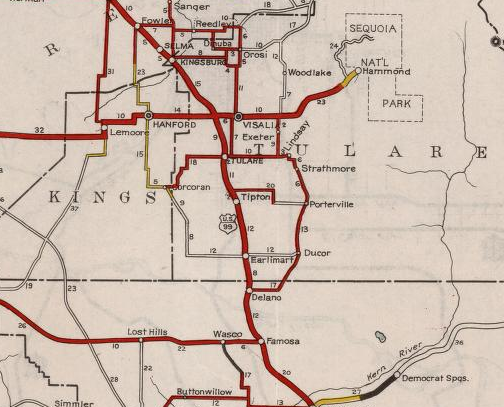
By 1934 the southern terminus of LRN 129 was shifted to Famoso via Famoso-Porterville Highway where it terminated at US Route 99/LRN 4. The new alignment of LRN 129 can be seen entering Famoso on the 1934 Division of Highways State Map.

In the August 1934 California Highways & Public Works ("CHPW") guide the Sign State Routes were announced. CA 65 was added to LRN 129 and terminated in Famoso at US 99/LRN 4.


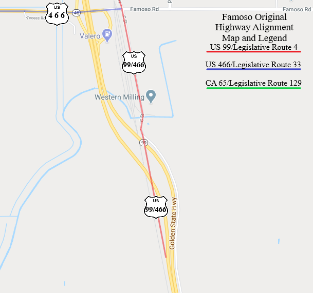
1934 was also notable for highways in Famoso as it was the year that US Route 466 was commissioned as a nearly 500 mile route from Morro Bay, CA east to Kingman, AZ. US 466 eastbound entered Famoso via LRN 33 where it met US 99/LRN 4. US 466 eastbound followed US 99/LRN 4 southbound to Bakerfield.
The below map illustrations show the alignments of; US 99/LRN 4, US 466/LRN 33, and CA 65/LRN 129 through Famoso as they were 1934. Note; US 99/LRN 4 took two hazardous at-grade crossings of the Southern Pacific Railroad as cited above.

Traffic on US 99/LRN 4 and US 466/LRN 33 was already heavy by the mid-1930s. Removal of at-grade railroad overpasses were highly desired and generally were a priority for the Division of Highways on US 99/LRN 4 in San Joaquin Valley during the 1930s. The first reference to a recommendation of a new "railroad subway" in Famoso appears in the October 1935 CHPW guide.

The May 1936 CHPW guide cites that the railroad subway in Famoso was under construction and a similar subway structure in nearby Delano was recently completed.

US 99/US 466/LRN 4 is shown to be aligned over a new subway overpass onto a bypass route of Famoso on the 1938 Division of Highways State Map. The shift of US 99/US 466/LRN 4 onto the new bypass route extended the southern terminus of CA 65 within Famoso to the end of C Street. The bypass route of Famoso used by US 99/US 466/LRN 4 essentially was built on the same grade CA 99 on the Golden State Freeway occupies today.

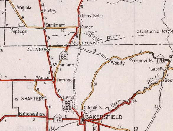
The new Ducor Cut-Off alignment of CA 65/LRN 129 first appears in an article in the July 1940 CHPW Guide. The Ducor Cut-Off is cited as being planned to shift CA 65 near the oil farms north of Bakersfield and shorten the distance of travel to Ducor by 5 miles over the then existing route on Famoso-Porterville Highway. A portion of the Ducor Cut-Off is shown to have been completed by July 1940.


The Ducor Cut-Off first appears on the 1940 Division of Highways State Map. A portion of the Ducor Cut-Off south of Ducor and the White River is shown completed as pictured above.
The Ducor Cut-Off appears as completed on the 1948 Division of Highways State Map and CA 65/LRN 129 is shown shifted to it off of Famoso-Porterville Highway. The shift of CA 65/LRN 129 marked the end of State Highway service through the heart of Famoso.

Part 2; the remains of the former highways through Famoso
My approach to Famoso was from CA 99 northbound Exit 44. The northbound Exit of CA 99 has a service station and small motel which appears to be from the 1950s era which displays the community name of Famoso.

From Exit 44 I made a right hand turn onto former US 466/LRN 33 eastbound on Famoso Road.


I followed Famoso Road east over the Union Pacific Main Freight Line to C Street at the Famoso town site. LRN 33 would have terminated at C Street but US 466 would have made a right hand turn to multiplex US 99/LRN 4 southbound.


C Street continues south of Famoso Road to a dead-end at the Union Pacific Railroad tracks. Map images on Google show that there is some relic asphalt south of the present CA 99 overpass of the Union Pacific Railroad. US 99/US 466/LRN 4 would have continued south originally towards Bakersfield. When the Southern Pacific Subway was completed circa 1937-1938 this became the south terminus of CA 65/LRN 129.


From the closed portion of C Street I turned around and headed north. C Street originally continued north of Famoso Road and became Famoso-Porterville Highway at Poso Creek. C Street now no longer continues north of Famoso Road and the bridge over Poso Creek has been removed.


Famoso-Porterville Highway is closed from Famoso Road north over Poso Creek to McCombs Road on private property. The original US 99/LRN 4 overpass of the Southern Pacific Railroad was located just south of McCombs Road. The photos below shows the intersection of McCombs Road and Famoso-Porterville Highway which is the closest approximation I could get of the original south terminus of CA 65/LRN 129 at US 99/LRN 4.


Further Reading
Continuing north on US Route 99 to McFarland and Delano?
Continuing south on US Route 99 to Bakersfield?
Comments
https://www.gribblenation.org/2020/03/old-california-state-route-65-on-famoso.html?m=1