
Interstate 5 in the Sacramento River Canyon


One of the more scenic segments of the Interstate system in California can be found on Interstate 5 from California State Route 151 in Shasta Lake City north through the Sacramento River Canyon to US Route 97 in Weed. 

As noted above Interstate 5 ("I-5") from California State Route 151 ("CA 151") in Shasta Lake north to US Route 97 ("US 97") in Weed is a highly scenic freeway corridor.  I-5 north of CA 151 crosses over the Shasta Lake Reservoir and follows the course of the Sacramento River Canyon to US 97 in Weed.  

This blog is part of the larger Gribblenation US Route 99 Page.  For more information pertaining to the other various segments of US Route 99 and it's three-digit child routes check out the link the below.


Part 1; the history of State Highway transportation between Shasta Lake and Weed

The emergence of the automobile in the early 20th Century in California led to the 1909 First State Highway Bond Act which was approved by voters during 1910.  The majority of the highways approved as part of the First State Highway Bond Act were largely well established routes of travel.  One such highway was Legislative Route Number 3 ("LRN 3") which was defined as a highway from "Sacramento to the Oregon Line."

By 1913 the Pacific Highway was created as a major Auto Trail between San Diego and Vancouver, British Columbia.  The Pacific Highway followed LRN 3 from the Oregon State Line south into downtown Red Bluff.  A very early LRN 3 from the Weed south to Redding can be seen on the 1917 California State Automobile Association Map.

 
The initial draft of the US Route System was approved by the Secretary of Agriculture during November of 1925.  The US Route System with in California was approved by California Highway Commission with no changes recommended by January 1926.  The initial alignment of US 99 was largely planned to follow the Pacific Highway through Sacramento Valley.  US 99 is shown on a map published in the 1926 California Highways & Public Works following LRN 3 into Red Bluff and heading south towards Woodland via LRN 7.  


Thusly US 99 appears on the 1925 Rand McNally Map of California from Weed south to Redding. 


During November of 1926 the US Route System was approved by the AASHO.  US 99 can be seen aligned from Weed south to Redding on the 1927 National Map Company Sectional Map


The Sacramento River and it's flood prone watershed would have a major effect on the alignment of US 99 which in turn influenced the later route I-5.  Sacramento Valley and the Sacramento River through much of the 19th Century and early 20th Century was prone to heavy winter floods.  A potential solution came in 1919 in the form of the Marshall Plan which was drafted by Robert Marshall and the United States Geological Survey ("USGS").  Marshall and the USGS proposed a proposed a dam near the town of Kennett at a site located downstream from the confluence of the Sacramento River and Pit River.  This new dam would serve as a flood control measure and as water storage for irrigation during dry summer months.  

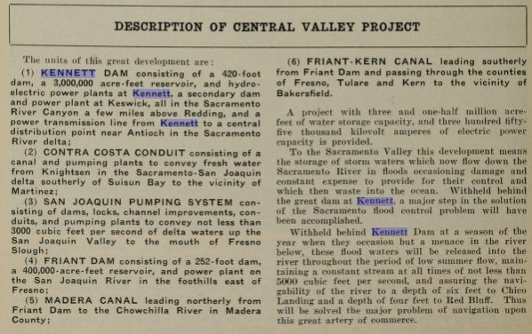
The Marshall Plan was proposed in Congress in 1921 but was ultimately rejected as legislation due to the high costs.  A less costly variation of the Marshall Plan was drafted by State Engineer Edward Hyatt in 1931 which was known as the State Water Plan.  The State Water Plan was essentially the genesis of the Central Valley Project ("CVP") and California State Water Project ("CSWP").  The State of California intended to finance the CVP and CSWP sale of revenue bonds.  The State authorized bonds for the CVP (which included Shasta Dam as a key piece) in 1933 but fell short of the funding required due to the Great Depression.  The CVP was subsequently authorized in 1935 as one of the many New Deal public works projects.  

Funding for the Central Valley Project along with it's potential benefits are outlined in the January 1932 California Highways & Public Works.  


The March 1932 California Highways & Public Works makes reference to "Kennett Reservoir" as the modern name of "Shasta Lake" had not been yet adopted.   


Kennett Dam and Reservoir appear as a conceptual illustration on the September 1933 California Highways & Public Works.  


The projects of the CVP are detailed in the October/November 1933 California Highways & Public Works.  Notably Kennett Dam is described with a scaled back height of 420 feet. 

 
The January 1934 California Highways & Public Works describes a recommendation by the Chief Engineers of the U.S. War Department recommending contributions of Federal Funds to CVP.   


The May 1935 California Highways & Public Works cites that Federal Funding was expected for the CVP upon Executive Order from President Franklin Roosevelt.  


The June 1935 California Highways & Public Works outlines the planned relocation of LRN 3/US 99 and the Southern Pacific Railroad around Kennett Lake.


The relocation of LRN 3/US 99 and the Southern Pacific Railroad are cited to be underway in the March 1936 California Highways & Public Works.  


For reference US 99/LRN 3 prior to Kennett Dam from the Siskiyou County Line south to Redding can be seen on the 1935 Division of Highways Map of Shasta County


For reference US 99/LRN 3 south of Weed to the Shasta County Line can also be seen on the 1935 Division of Highways Map of Siskiyou County.
 

A drawing of Kennett Dam appears on the March 1937 California Highways & Public Works


The final selection of the Kennett Dam site is announced in the same California Highways & Public Works issue.  


A ground breaking ceremony for Shasta Dam took place in the town of Kennett on September 12th, 1937.  Kennett was doomed as it lay upstream from the site of Shasta Dam as it was being built about a mile north of the ghost town of Coram.  Shasta Dam was intended to be 800 feet high and would be constructed by Pacific Constructors Incorporated.  Pacific Constructors Incorporated set up several company camps which would house workers at the site of Shasta Dam.  These company towns were known as; Central Valley, Toyon, Project City, Pine Grove, and Summit City.  Project City was located at what was LRN 3/US 99 on Cascade Boulevard and Shasta Lake Boulevard (future CA 151).  

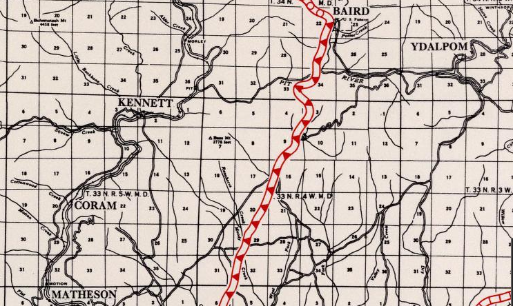
Coram and Kennett can be seen along the Sacramento River on the 1935 Division of Highways Map of Shasta County.  In just a couple years the landscape around the confluence of the Sacramento River and Pit River would change forever.  

Kennett Dam first appears as Shasta Dam in the October 1937 California Highways & Public Works

In November 1938 construction of a diversion tunnel at Shasta Dam began so that the foundations could be built.  The November 1939 California Highways & Public Works details the realignment of US 99/LRN 3 and the design of the new Pit River Bridge. 


The Pit River Bridge appears on the cover of the October 1941 California Highways & Public Works.  The photo displayed on the cover shows the Southern Pacific Railroad deck located below the road deck of US 99/LRN 3.  
 

The October 1941 California Highways & Public Works goes on to state that grading for the realignment of US 99/LRN 3 above the Shasta Lake Reservoir was completed.  The Pit River Bridge is shown only to have one span section not to have been installed.  The article goes on further in noting that both the Pit River Bridge and the new alignment of US 99/LRN 3 were expected to be opened by Summer 1942.  The unique dual rail/highway purpose of the Pit River Bridge is discussed and the earlier arch concrete 1915 Pit River Bridge can be seen the construction photos. 


This photo below of the 1915 Pit River Bridge on the Pacific Highway is sourced from the Shasta County Historical Society.  
 

An older bridge over the Pit River can be seen in 1901 and is hosted on bridgehunter.com.   This bridge was located upstream from the 1915 Pit River Bridge and was designed for wagon traffic. 


The December 1941 California Highways & Public Works shows the final span of the Pit River Bridge being constructed. 


The February 1943 California Highways & Public Works shows the completed Pit River Bridge and cites the new alignment of US 99/LRN 3 around Shasta Dam (including the then new Antlers Bridge) as opened to traffic.  


Construction of said foundations at Shasta Dam began in July 1940.  Construction of the middle section of Shasta Dam and the spillway began during 1943.  Shasta Dam began to impound water into it's reservoir in February 1944 and the last layer of concrete was laid in January 1945.  At the time of it's completion Shasta Dam was the second highest in the world only behind Hoover Dam.  

Shasta Dam under construction during June of 1942.


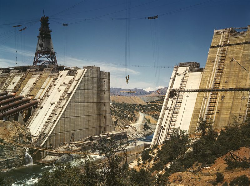
Shasta Dam under construction in March 1943.
 
 
Below the town of Kennett can be seen being flooded by the rising waters of Shasta Lake during 1944.
 

The newly completed Shasta Dam can be seen on the cover of the January/February 1946 California Highways & Public Works

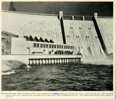
The same California Highways & Public Works issue details flood control measures at Shasta Dam. 


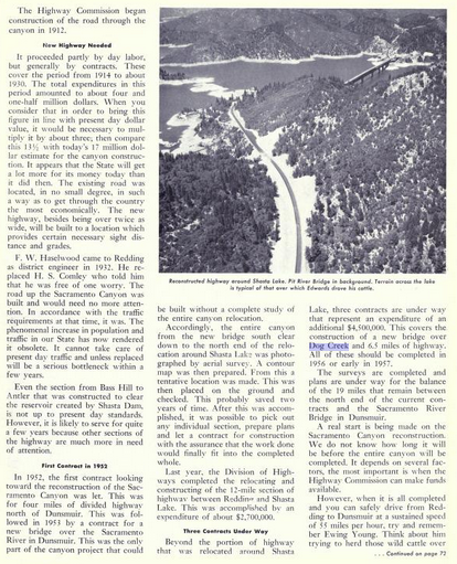
The Federal Aid Highway Act was enacted on June 29th, 1956 which put US 99/LRN between Weed-Shasta Lake City on the planned route of I-5.  The reconstruction of US 99/LRN 3 in the Sacramento River Canyon along with much of it's history as a transportation corridor is discussed in the May/June 1956 California Highways & Public Works.  The first contract to rebuild US 99/LRN 3 in the Shasta River Canyon came in 1952 which was for 4 miles of divided highway north of Dunsmuir.  This was followed by a new contract in 1953 to construct a new bridge over the Sacramento River in Dunsmuir.  12 miles of US 99/LRN 3 north from Redding to Shasta Lake City were cited to have been completed in 1955.  The article goes on further in terms of describing three ongoing contracted projects in the Sacramento River Canyon which included a new bridge over Dog Creek and 6.5 miles of additional highway.  Surveys for reconstructing the remaining 19 miles of US 99 between Shasta Lake and Dunsmuir were cited to be underway.  


The opening of the Dog Creek Bridge is discussed in the January/February 1957 California Highways & Public Works.  The new Dog Creek Bridge along with 6 miles of divided highway is stated to have opened as a realignment of US 99/LRN 3 in December 1956.  


The May/June 1958 California Highways & Public Works cites that 6.9 miles of new divided highway for US 99/LRN 3 in the Sacramento River Canyon from near Lamoine to the vicinity of Shotgun Creek were under construction.   


The first full freeway segment of US 99/LRN 3 in the Sacramento River Canyon are stated to be planned be constructed near Dunsmuir.


A new segment of US 99/LRN 3 at Slate Creek in the Sacramento River Canyon appears in the November/December 1959 California Highways & Public Works


The November/December 1960 California Highways & Public Works cites a freeway segment of US 99/LRN 3 opening north of downtown Weed.  

 
During the 1964 State Highway Renumbering what had been US 99/LRN 3 between Weed-Shasta Lake City was redefined legislatively as Route 5 in anticipation of I-5 being completed.  US 99 appears on the 1964 Division of Highways State Map legislatively as Route 5 between Weed-Shasta Lake City.  

 
The November/December 1964 California Highways & Public Works shows the recently completed I-5 bypass (cited as November 1964) at the Lake Street interchange.  


The 1965 Division of Highways State Map is the first to show I-5 signed as the primary route in the Sacramento River Canyon.  US 99 doesn't disappear from Division of Highways Maps until 1967.  Segments of I-5 between Weed-Mount Shasta and Delta-O'Brien are shown still to be expressway grade. 

The 1966 Division of Highways State Map shows the planned bypass route for I-5 around downtown Weed.  

Said I-5 bypass of Weed is shown complete on the 1967 Division of Highways State Map.  The I-5 bypass of Weed would have functionally extended US 97 from downtown Weed to the new freeway alignment via former US 99 on South Weed Boulevard.  What had been US 99 on North Weed Boulevard became CA 265.  According to CAhighways.org US 97 was extended and CA 265 was created via 1965 Legislative Chapter 1402.  I-5 south of Weed to Mount Shasta City is still shown to be an expressway. 

A segment of I-5 between Delta and O'Brien appears upgraded to freeway standards on the 1969 Division of Highways State Map.

I-5 is shown as a freeway from Weed south to Mount Shasta on the 1975 Caltrans State Map.  

Despite I-5 being functionally four lane fully in the Sacramento River Canyon segments remained expressway grade into the 1980s and 1990s.  According to Scott Parker ("Sparker") of AAroads a segment of I-5 was upgraded to full freeway standards north the oxbow north of Vollmers in late 1987.   This can be seen on the 1988 Caltrans State Map.  


The final section of I-5 to be built to Interstate standards in the Sacramento River Canyon was the Vollmers-Castella segment in early 1992.  According to Scott Parker said segment of I-5 was gradually built to Interstate standards over the course of six years. 

In 2017 I-5 in the Sacramento River Canyon saw a minor improvement when the 1941 Antlers Bridge was replaced by a new bridge


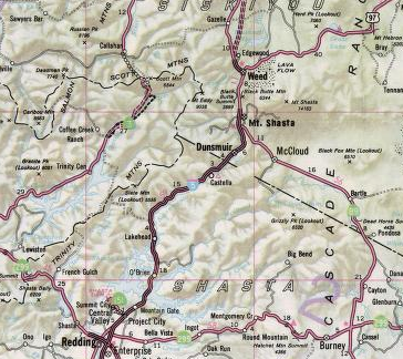
Part 2; a drive on Interstate 5 north through the Sacramento River Canyon from Shasta Lake City to Weed

Our drive northbound I-5 through the Sacramento River Canyon begins at Exit 685 for CA 151 in Shasta Lake City.  Traffic is advised that CA 151/Shasta Dam Boulevard accesses Shasta Dam.  Cascade Boulevard is the historic alignment of US 99 through Shasta Lake City.


From CA 151 I-5 north is signed as 45 miles from Dunsmuir and 54 miles from Mount Shasta City.  

I-5 north Exit 687 accesses Wonderland Boulevard, Old Oregon Trail, and Mountain Gate. 


I-5 north Exit 689 accesses Wonderland Boulevard and Fawndale Road. 


I-5 north Exit 690 accesses Bridge Bay Road. 


I-5 northbound begins to approach the Shasta Lake Reservoir and crosses the Pit River Bridge.  Upon crossing the Pit River Bridge I-5 north accesses Turntable Bay Road via Exit 692. 


I-5 north of Exit 692 passes by a rest area.  I-5 north Exit 695 accesses O'Brien, O'Brien Inlet Road, Packers Bay Road, and Shasta Caverns Road. 


I-5 north Exit 698 accesses Gilman Road and Salt Creek Road. 


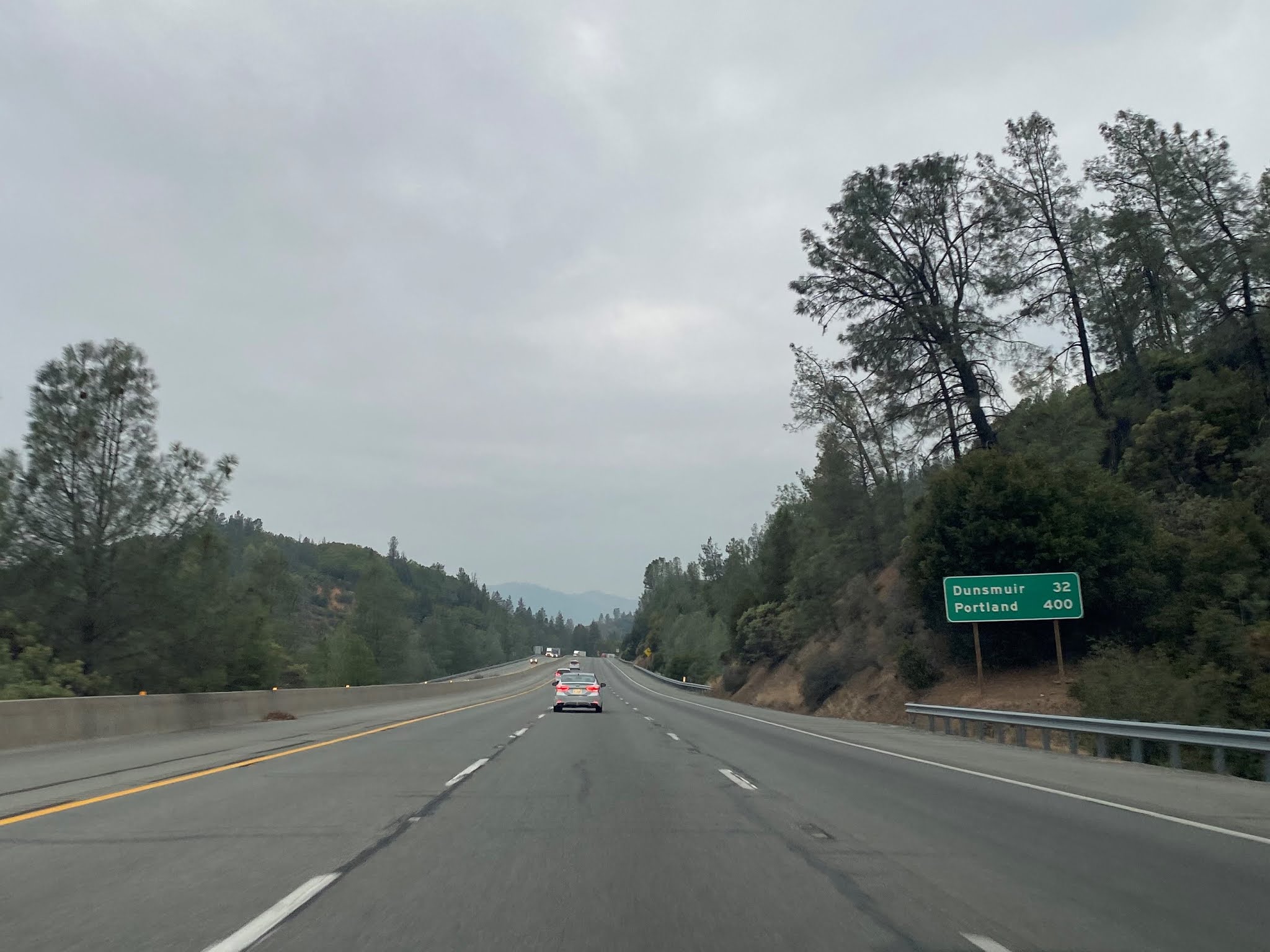
North of Exit 698 Dunsmuir is signed as 32 miles away on I-5 north. 

I-5 north crosses the new Antlers Bridge approaching Exit 702.  Exit 702 accesses Lakehead, Lakeshore Drive, and Antlers Road. 


I-5 north Exit 704 accesses Lakehead and Riverview Drive. 


I-5 north leaves the boundaries of the Shasta Lake National Recreation Area.  At Exit 707 I-5 north accesses; Vollmers, Delta, Dog Creek Road, and Delta Road.


I-5 north follows the Sacramento River towards Exit 710 for Lamoine and Slate Creek Road. 


I-5 north Exit 712 accesses Pollard Flat. 

I-5 north Exit 714 accesses Gibson Road. 


From I-15 Exit 714 Dunsmuir is signed as 16 miles away. 

I-5 north Exit 718 accesses Sims Road. 


I-5 north Exit 720 accesses Flume Creek Road. 


I-5 north Exit 721 accesses Conant Road.


I-5 north Exit 723 accesses Sweetbrier Avenue. 


North of Exit 723 I-5 north has a vista of Mount Shasta. 


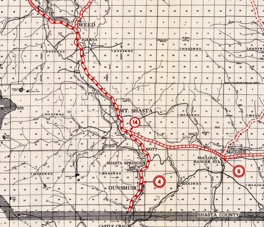
I-5 north Exit 724 accesses Castella and Castle Crags State Park.  Main Street is the original alignment of US 99 in Castella.


I-5 north Exit 726 accesses Soda Creek Road. 


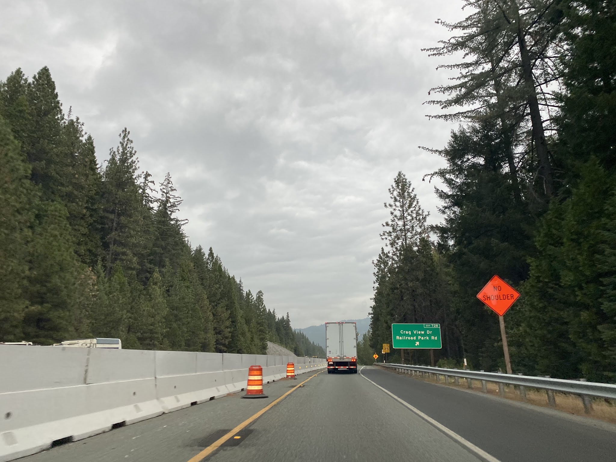
I-5 north Exit 727 accesses Crag View Road.


I-5 north Exit 726 accesses Crag View Road and Railroad Park Road.


I-5 north crosses the Siskiyou County Line and accesses Dunsmuir via Exit 729/Dunsmuir Avenue.  Dunsmuir Avenue is the original alignment of US 99 in Munsmuir.


I-5 north Exit 730 also accesses Dunsmuir Avenue. 

I-5 north Exit 732 accesses Dunsmuir Avenue and Siskiyou Avenue. 


I-5 north Exit 734 accesses Mott Road.


I-5 north enters Mount Shasta City and accesses CA 89 at Exit 736.


I-5 north Exit 737 accesses Mount Shasta Boulevard.  Mount Shasta Boulevard is signed as Historic US 99 and I-5 Business. 


Weed is signed 9 miles from I-5 north Exit 737. 

I-5 north Exit 738 accesses Lake Street and Lake Siskiyou. 


I-5 north Exit 741 accesses Abrams Lake Road. 


I-5 north Exit 743 accesses Summit Drive and Truck Village Drive.


I-5 north enters Weed and accesses Vista Drive at Exit 745. 


I-5 north Exit 747 accesses US 97/Weed Boulevard.  As noted above Weed Boulevard was the alignment of US 99. 


Further Reading

Continuing north on US Route 99 to Dunsmuir?


Continuing south on US Route 99 to Redding and Anderson? 

Comments

Popular posts from this blog

Old River Lock & Control Structure (Lettsworth, LA)

  The Old River Control Structure (ORCS) and its connecting satellite facilities combine to form one of the most impressive flood control complexes in North America. Located along the west bank of the Mississippi River near the confluence with the Red River and Atchafalaya River nearby, this structure system was fundamentally made possible by the Flood Control Act of 1928 that was passed by the United States Congress in the aftermath of the Great Mississippi River Flood of 1927 however a second, less obvious motivation influenced the construction here. The Mississippi River’s channel has gradually elongated and meandered in the area over the centuries, creating new oxbows and sandbars that made navigation of the river challenging and time-consuming through the steamboat era of the 1800s. This treacherous area of the river known as “Turnbull’s Bend” was where the mouth of the Red River was located that the upriver end of the bend and the Atchafalaya River, then effectively an outflow

Interstate 10S and the original Interstate 110 in California

Interstate 10S is a short spur of Interstate 10 along San Bernardino Freeway in downtown Los Angeles.  Interstate 10S begins at the Santa Ana Freeway (US Route 101) and extends east to Interstate 5 where it merges into mainline Interstate 10.  Interstate 10S is one of the oldest freeway segments in Los Angeles having been part of US Routes 60, 70 and 99 when it was part of the corridor of the Ramona Expressway.  The current corridor of Interstate 10S was assigned as Chargeable Corridor H following the passage of the 1956 Federal Highway Aid Act.  Interstate 110 was a short-lived designation which comprised the segment San Bernardino Freeway from US Route 101 to Interstate 5 between 1964-1968.  The original Interstate 110 was dropped as a Chargeable Corridor during 1965 and consolidated as Interstate 10S during 1968.   The original Interstate 110 can be seen as the blog cover photo as it was featured on the 1964 Division of Highways Map.  Below the entire 0.65-mile length of Interstate

Vicksburg Bridge (Vicksburg, MS)

  Located a few hundred feet downriver from the Old Vicksburg Bridge, the Vicksburg Bridge, or the “New” Bridge, serves as the city’s vehicular crossing of the Mississippi River on the main highway connecting Vicksburg with northeastern Louisiana to the west and the state capital of Jackson to the east. The completion of the original Vicksburg Bridge in 1930 was seen as a huge success and the bridge proved to be a profitable entity for both road and railroad interests along the path of the Dixie Overland Highway and the subsequent US Highway 80 corridor. In the years after the creation of the National Interstate Highway System, planning commenced on a new bridge at the site that would relieve the congestion on the existing bridge while providing for a more modern crossing of the river that would be safe for all vehicles. The construction of the new bridge at Vicksburg was completed in 1973 and its design intentionally mimics that of its predecessor nearby. This was due in large part