Athlone was a siding of the Southern Pacific Railroad located in Merced County on the alignment of what was US Route 99 between the cities of Chowchilla and Merced. The Athlone corridor of US Route 99 was one of the first in San Joaquin Valley to fully upgraded to four lane expressway standards. The Athlone expressway corridor was inherited by California State Route 99 when US Route 99 was truncated to Ashland, Oregon during June 1965. The four-lane expressway through Athlone was the last segment of what had been US Route 99 in the Wheeler Ridge-Sacramento corridor to be bypassed by a freeway. The Athlone expressway corridor was bypassed by the modern California State Route 99 freeway in 2016. Despite being put on a road diet and narrowed what was the Athlone expressway corridor still displays evidence of being part of US Route 99.
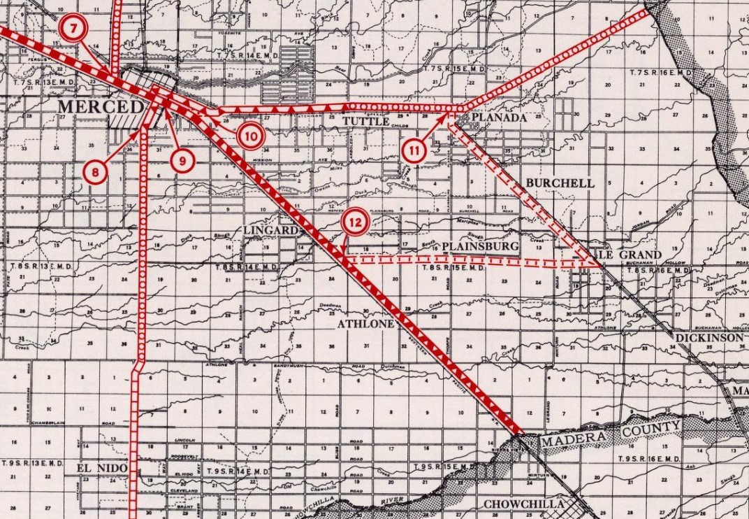
Above the blog cover photo displays the Athlone expressway corridor of US Route 99 south of Merced as depicted in the July 1939 California Highways & Public Works. Below US Route 99 can be seen passing through Athlone on the 1935 Division of Highways Map of Merced County.
This blog is part of the larger Gribblenation US Route 99 Page. For more information pertaining to the other various segments of US Route 99 and it's three-digit child routes check out the link the below.
Part 1; the history of US Route 99 and California State Route 99 through AthloneAthlone was founded 1874 along the main freight line of the Southern Pacific Railroad in San Joaquin Valley as a siding facility and town site. Athlone was named in honor of an Irish community of the same name. Athlone was largely not successful growing beyond it's siding origins as the community had sporadic Post Office service from 1881 to 1937. Athlone can be seen along the Southern Pacific Railroad on the 1882 Bancroft's Map of California and Nevada.
The emergence of the automobile in the early 20th Century in California led to the 1909 First State Highway Bond Act which was approved by voters during 1910. The majority of the highways approved as part of the First State Highway Bond Act were largely well-established routes of travel. One such highway was
Legislative Route Number 4 ("LRN 4") which was defined as a highway from "Sacramento to Los Angeles."


The initial draft of the US Route System was approved by the Secretary of Agriculture during November of 1925. The US Route System within California was approved by California Highway Commission with no changes recommended by
January 1926. The initial alignment of US Route 99 (US 99) was planned to follow LRN 4 from Sacramento to Los Angeles. US 99 is shown on a map published in the 1926 California Highways & Public Works following LRN 4 south from Sacramento through Athlone.
During November of 1926 the US Route System was approved by the American Association of State Highway Officials (AASHO). US 99 can be seen aligned through Athlone via the Chowchilla-Merced corridor on the
1927 National Map Company Sectional Map.
The
November 1937 California Highways & Public Works features a design sketch of the upcoming four-lane expressway upgrade to US 99/LRN 4 in the Chowchilla-Merced corridor. The existing grade of US 99/LRN 4 is shown to be only 20 feet wide with almost no drainage grade.
The
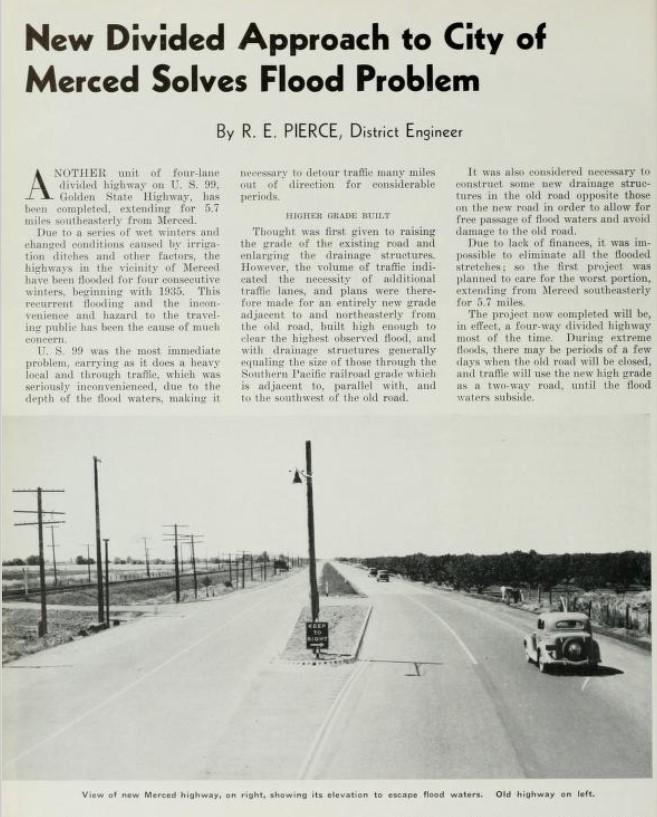
July 1939 California Highways & Public Works features a new divided expressway segment of US 99/LRN 4 extending 5.7 miles south of Merced. Two new lanes of US 99/LRN 4 are described as being built alongside the existing two. The existing lanes of US 99/LRN 4 are described as having received drainage upgrades but may still be subject to flooding in severe weather.


The Ocotber 1941 California Highways & Public Works discusses the widening of US 99/LRN 4 in the Mecred Area. The improvements to US 99/LRN 4 in the Merced saw several new bridges installed, namely at Bear Creek in 1940 which saw the removal of the Redwood Gateway Arch. US 99/LRN 4 between Chowchilla-Merced is stated to have been completed to four-lane expressway standards by June 1939. Active construction to upgrade the remainder of US 99/LRN 4 between Merced-Chowchilla to expressway standards is stated to be underway and would include a new bridge over the Chowchilla River.


The Chowchilla Freeway upgrade of US 99 is discussed in the March/April 1957 California Highways & Public Works. The Chowchilla Freeway is described as being aligned east of Chowchilla Boulevard on a new bypass route for US 99/LRN 4. The 1930 Southern Pacific Railroad subway is discussed as being converted from two-way traffic to use exclusively for northbound US 99 traffic. The US 99/CA 152 junction upgrade is described as being converted from being at-grade to a series of ramps. Work on the Chowchilla Freeway is described as having broken ground on March 23rd, 1956 with an anticipated completion coming in July 1957. The Chowchilla Freeway corridor would tie into the existing expressway towards Merced via Athlone near Vista Avenue in Merced County.


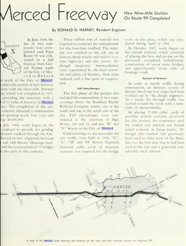
The July/August 1964 California Highways & Public Works announced the completion of the Merced Freeway realignment of US 99 in Merced. The Merced Freeway is cited to have begun during July of 1960 and opened between Gerard Avenue north to the Atwater Bypass in June 1964. Upon the completion of the Merced Freeway CA 140 moved to a multiplex of US 99 from 16th Street to V Street. CA 59 subsequently moved to a multiplex of US 99 from R Street (current Martin Luther King Jr. Way) to V Street. The project map depicts the Merced Freeway tying into the existing expressway towards Chowchilla via Athlone expressway at Gerald Avenue.
The AASHO Renumbering database shows that US 99 was approved to be truncated out of California to Ashland, Oregon by the AASHO Executive Committee on June 29th, 1965. This measure would have become effective on New Year's Day 1966. This measure saw California State Route 99 (CA 99) replace US 99 through Athlone.
Ultimately the Athlone expressway on
CA 99 became the last segment between Wheeler Ridge-Sacramento to be upgraded to freeway standards. According to cahighways.org the California Transportation Commission (CTC) considered widening the Merced-Chowchilla corridor of CA 99 to freeway standards during July 2005 between Postmiles MAD 29.33 to MER 13.04. A freeway agreement between Caltrans and Merced County was signed on April 24th, 2007.
Ultimately bids to construct the MAD 29.33-MER 13.04 freeway corridor of CA 99 were put out during Spring 2012. A close out target for construction of the MAD 29.33-MER 13.04 freeway corridor was scheduled for completion during August 2016. Upon completion of the Merced-Chowchilla Freeway corridor superseded much of the Athlone expressway was narrowed it to two lanes between Postmiles MER 1.2-R10.5. The relinquishment of the former CA 99 Athlone expressway corridor between Postmiles MER 1.2-R10.5 (Vista Avenue to McHenry Avenue) was authorized by the CTC during March 2017. The completion of the Merced-Chowchilla Freeway brought the entirety of CA 99 between Wheeler Ridge-Sacramento up to full continuous freeway standards.
Part 2; a drive on former US Route 99/California State Route 99 in the Athlone expressway corridor
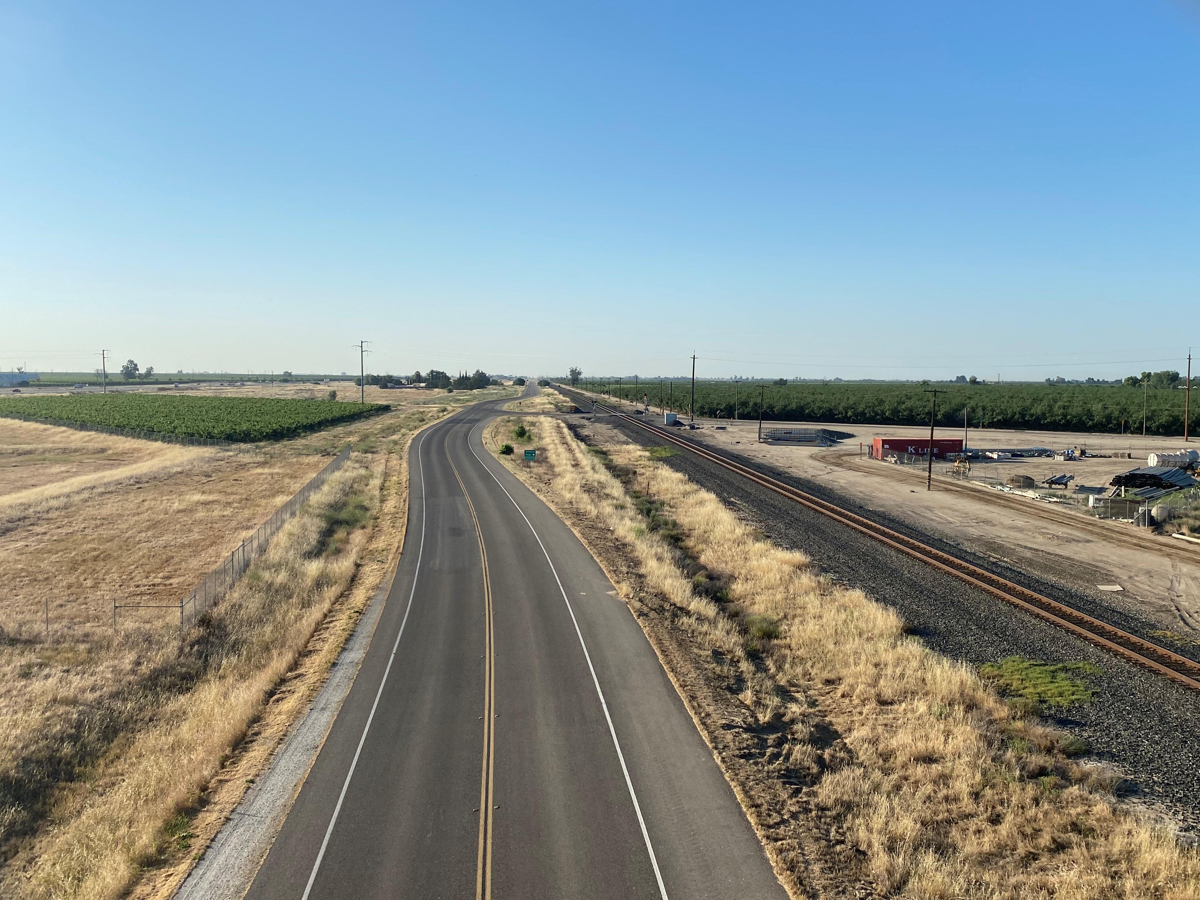
The Athlone expressway corridor is now signed as Kahlon Road. From the modern CA 99 freeway traffic can access Kahlon Road from Exit 176 and taking it west towards Sandy Mush Road.
The Plainsburg Road/Sandy Mush Road overpass also crosses over Kahlon Road. Below the faces north towards Merced. Present Kahlon Road was once the southbound lanes US 99/CA 99 of the Athlone expressway corridor. What was the northbound lanes of Athlone expressway can be seen to the right of Kahlon Road via a largely razed roadbed grade.
The view below overlooks Kahlon Road towards Chowchilla. The northbound lanes of the Athlone expressway corridor would have been immediately left of Kahlon Road.
Former US 99/CA 99 on Kahlon Road can be accessed from Gilhane Road from the Plainsburg Road/Sandy Mush Road overpass.
As noted in the Part One the beginning of the relinquished corridor of CA 99 on Kahlon Road begins at what was Postmile MER 1.2 at Vista Avenue. Facing south towards Chowchilla one can observe how Kahlon Road would have once transitioned into where the current CA 99 freeway now lies.
Facing northbound on Kahlon Road the Dutchman Creek Bridge near Merced Truck & Auto Plaza still shows evidence of the four-lanes of the Athlone expressway.
The same view from the June 2014 Google Street View image.
The Dutchman Creek Bridge still partially displays a Caltrans spec date stamp of 1926.
Facing north on Kahlon Road at Merced Truck & Auto Plaza is a now lonely view where traffic once was almost constant on US 99/CA 99.
The Dutchman Creek Bridge on Kahlon Road north of Merced Truck & Auto Plaza still features a Caltrans bridge placard that reads "99 MER 2.63."
The same view from Google Street View during June 2014.
The same view from Google Street View during May 2015 depicts the northbound lanes of the Athlone expressway in the process of being razed.
What is now the Vasche Court intersection from Kahlon Road was once part of Plainsburg Road.

Facing northward on Kahlon Road at the Gilhane Road intersection. Gilhane Road was built specifically to connect the former Athlone expressway corridor to the Sandy Mush Road/Plainsburg Road overpass.
Modern Kahlon Road facing north towards the Sandy Mush Road/Plainsburg Road overpass.
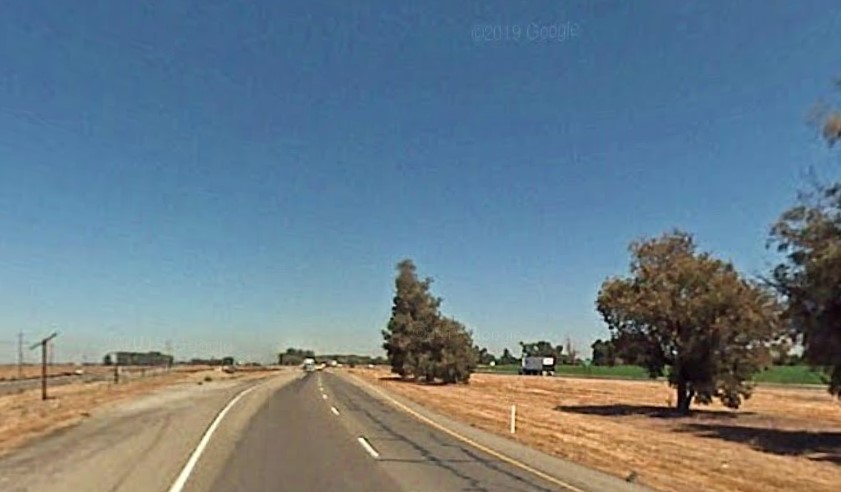
The same view from the June 2014 Google Street View image reveals the partially completed Sandy Mush Road/Plainsburg Road overpass lapping the northbound lanes of the Athlone expressway.
The May 2015 Google Street View image reveals southbound CA 99 using Kahlon Road whereas the former northbound expressway lanes are shown to be razed.
Modern Kahlon Road facing the Athlone Road intersection. This is one of the few pieces of evidence of the site of Athlone. The town site of Athlone was plotted on the right of the photo where the southbound lanes of the CA 99 freeway are now located.
The same view from the June 2014 Google Street View image.
The August 2007 Google Steet View image reveals trees lined the median of CA 99 in the Athlone expressway at Athlone Road.
Kahlon Road facing northward at Deadman Creek still has a Caltrans bridge identification placard which reads "99 MER R5.24."
The June 2014 Google Street View images reveals the northbound lanes of the Athlone expressway were already razed.
The October 2012 Google Street View image.
Modern Kahlon Road rises an embankment to reach Le Grand Road.
Kahlon Road facing northbound at Ranch Road.
The same view from the September 2012 Google Street View image.
Kahlon Road continues northbound to an intersection with Lingard Road. Lingard was another siding facility along the Southern Pacific Railroad (now Union Pacific Railroad) which appears on some early maps associated with US 99. It is unclear who founded Lingard, but it was likely some sort of commercial venture and not an original siding.
Kahlon Road facing north at the Mariposa Creek Bridge reveals a Caltrans bridge identification placard which reads "99 MER R9.39."
The June 2014 Google Street View image reveals the partially completed southbound lanes of the CA 99 freeway.
The October 2012 Google Street View image.
Another Caltrans bridge identification placard at Duck Slough can be seen along northbound Kahlon Road.
The Duck Slough Overflow bridge displays Postmile 99 MER 9.89 from northbound Kahlon Road. The relinquished Athlone expressway corridor ends about a half mile ahead as Kahlon Road runs meets McHenry Road.
Further Reading
Continuing north on US Route 99 to Merced?
Continuing south on US Route 99 to the Chowchilla area?


Comments