Adairville, Kentucky

Andrew Jackson shot and killed a man here once.


In 1806, at a spot a few miles west of town on the banks of the Red River, Andrew Jackson and Charles Dickinson settled a lengthy and heated dispute over a canceled horserace and comments made about Jackson's wife.  It takes a bit of research to find the spot where Jackson killed Dickinson, but the general area is the north shore of the Red River along Barren Plains Road. 

The general area where the Jackson-Dickinson Duel occurred.  Off of Barren Plains Road - Adairville, KY.
Though both men were residents of Tennessee, the Volunteer State had outlawed duels by 1806.  Kentucky had not.  The two men agreed on the site, date, and logistics of the duel.  Twenty-four paces apart and Dickinson - a renowned marksman - shooting first.  Indeed, Dickinson shot first - hitting Jackson in the chest but stopping before his heart.  Jackson, though wounded, remained standing and fired a shot into Dickinson's abdomen. Dickinson would die one day later. (1)

Though the dueling grounds are not marked with any historical marker or monument, on US 431 in Adairville - there is a Kentucky Historical Marker noting the event.  In Adairville's public square, there is artwork depicting the scene.

US 431 through Adairville.

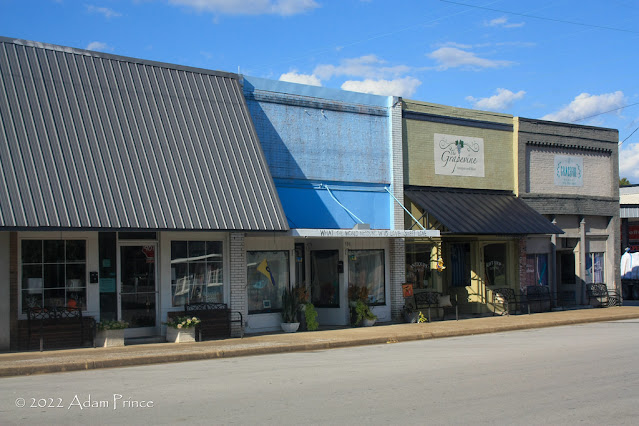
Downtown Adairville

Adairville is a small town of under 1,000 people on US 431 just north of the Tennessee State Line.  It was first known as Dromgooles' Station - and was known as that at the time of the Jackson-Dickinson Duel.  In 1818, the community changed its name to Adairsville when the town was platted by General Robert Ewing and Michael Traughber.  Adairsville was named after John Adair, who commanded Kentucky troops in the Battle of New Orleans and would serve as Governor of Kentucky from 1820-1824.  Later in the 19th century, the 's' in Adairsville was dropped, and Adairville would become the town's formal name. (2)

This former bank is now home to an art studio and apartments.

Since 1947, Adairville has hosted a strawberry festival.  Held over the third weekend in May, it is one of the numerous strawberry festivals throughout Kentucky.  

How To Get There:

Sources:

Further Reading:

Comments

Popular posts from this blog

Dillon Road

Dillon Road is a 34.2-mile highway located in northern Coachella Valley of Riverside County, California.  Dillon Road begins at Avenue 48 on the outskirts of Indio and ends to the west at California State Route 62 near San Gorgonio Pass.  Dillon Road was developed the 1930s as a construction road for the Colorado River Aqueduct.  Dillon Road serves as a northern bypass to much of the development of Coachella Valley.  Dillon Road is known for it's frequent dips and spectacular views of San Gorgonio Pass.   Part 1; the history of Dillon Road Dillon Road was constructed as a haul road for the Colorado River Aqueduct through Coachella Valley.  The Colorado River Aqueduct spans 242 miles from Parker Dam on the Colorado River west to Lake Mathews near Corona.  Construction of the Colorado River Aqueduct began during January 1933 near Thousand Palms and was made functional on January 7, 1939.  West of Berdoo Canyon Road the alignment of Dillon Road is largely concurrent with the Colorado

Tehachapi-Willow Springs Road

Tehachapi-Willow Springs Road is an approximately 21-mile highway located in southeast Kern County.  Tehachapi-Willow Springs Road begins at Tehachapi Boulevard (former US Route 466) in Tehachapi and crosses the Tehachapi Mountains via the 4,820-foot-high Oak Creek Pass.  Tehachapi-Willow Springs Road enters Antelope Valley of the wider Mojave Desert and passes by the historic stage station of Willow Springs to a southern terminus at Rosamond Boulevard.  Tehachapi-Willow Springs Road has historic ties to the Havilah-Los Angeles Road and Stockton-Los Angeles Road due to the once reliable presence of water at Willow Springs. Part 1; the history of Tehachapi-Willow Springs Road Oak Creek Pass and Willow Springs were known to the local tribes of the Tehachapi Mountains for generations.  The first documented European crossing of Oak Creek Pass was during 1776 as part of an expedition by Francisco Garces.  Oak Creek Pass is as used again by John C. Fremont during an 1844-1845 expedition to e

Former California State Route 152 east of Pacheco through the San Luis Reservoir

Dinosaur Point Road east of Pacheco Pass to the waters of the San Luis Reservoir is the original alignment of California State Route 152.  Since July 1965, California State Route 152 has been realigned east of Pacheco Pass via a modernized expressway.  The original alignment of California State Route 152 on occasion reemerges from the San Luis Reservoir at Dinosaur Point.  Pictured above as the blog cover is the original alignment of California State Route 152 at Dinosaur Point disappearing eastward into the waters of the San Luis Reservoir.  Below California State Route 152 can be seen passing through what is now the San Luis Reservoir east of Pacheco Pass on the 1935 Division of Highways Map of Merced County. Part 1; the history of California State Route 152 east of Pacheco Pass through the San Luis Reservoir site The present site of the San Luis Reservoir during the era of Alta California was part of Rancho San Luis Gonzaga.  Rancho San Luis Gonzaga was granted to Francisco Jose Riv