This past week I drove the entirety of California State Route 138 from CA 18 in Crestline westward to Interstate 5 near Gorman.

The present alignment of CA 138 is 86 miles in length and travels in an east/west configuration. CA 138 is a notable highway given it closely follows the San Andreas Fault for much of it's alignment. CA 138 was one of the original run of 1934 Signed State Highways which was aligned on Legislative Route 59 between US 66 in Cajon west to US 99 near Tejon Pass. Interestingly east of Phelan it the original definition of CA 138 appears to have been intended to be co-signed with CA 2 to US 66 in Cajon Pass.
1934 Department of Public Works document annoucing the Signed State Highways
The multiplex of CA 2/CA 138 to Cajon Pass appears to have never been signed in-field. On the 1938 State Highway Map only CA 2 is seen meeting US 66/395 in Cajon Pass. CA 138 appears to end at CA 2 near Phelan.
1938 State Highway Map
LRN 59 was first adopted into the State Highway system as part of the 1919 Third State Highway Bond act between Baileys (a local near Gorman and the Old Ridge Route) east to Lancaster. This segment of LRN 59 closely aligned with the path of the historic Stockton-Los Angeles Road. In 1931 LRN 59 was extended east to LRN 31 in Cajon Pass and by 1933 it was extended to LRN 43 near Lake Arrowhead.
CAhighways.org on LRN 59
What would become CA 138 on LRN 188 was adopted into the State Highway system between LRN 59 and LRN 43 near Crestline in 1933.
CAhighways.org on LRN 188
Describing the alignment history of CA 138 is difficult given there has been so many shifts and abandoned ideas. That being the case I'll cover the alignment history in segments starting with CA 138 from I-5 east towards CA 14.
The original 1934 route of CA 138 from Gorman to Lancaster used the following route:
- Gorman Post Road east from US 99 in Gorman.
- Lancaster Road on modern CA 138 to Neenach.
- Modern 245th Street West from Neenach to Lancaster Road.
- Lancaster Road to Fairmont.
- Lancaster Road from Fairmont to 120th Street West.
- Avenue I to Sierra Highway/LRN 23 in Lancaster.
By 1956 CA 138/LRN 59 shown shifted onto Avenue D east from Neenach to US 6/LRN 23 north of Lancaster. This change can be observed by comparing the 1955 and 1956 State Highway Maps.
1955 State Highway Map
1956 State Highway Map
According to CAhighways.org a new proposed alignment of LRN 59 was legislatively defined running along what is modern Signed County Route N2 from CA 138 at Quail Lake southeast to Palmdale. Ironically this would have put another part of the Old Ridge Route back into the State Highway system but it ultimately never happened. CA 138/LRN 59 from Quail Lake east to US 6/LRN 23 was given a new LRN 267 designation which can be seen on the 1960 State Highway Map.
1960 State Highway Map
During the 1964 Highway renumbering the proposed route of LRN 59 between Quail Lake and Palmdale was assigned LRN 138. CA 138 to the north was assigned as part of LRN 48.
1964 State Highway Map
The path of CA 138 was eventually moved to a new freeway/expressway alignment which bypassed the Old Ridge Route alignment on Gorman Post Road. This new alignment appears to have been complete by 1967.
1967 State Highway Map
Eventually plans to route CA 138 along Signed County Route N2 were abandoned by 1996 according to CAhighway.org and the legislative definition of CA 48 was changed back to CA 138. The most recent studies by Caltrans suggest that CA 138 will largely become a four-lane expressway between I-5 and CA 14.
Previously I drove a large portion of the original route of CA 138 between the Old Ridge Route and Lancaster which can be found in the below blog:
Legend of the Ridge Route
Between Lancaster and Palmdale the route of CA 138 is presently multiplexed on the Sierra Freeway with CA 14. The original route of CA 138 would have multiplexed CA 7 on Sierra Highway until US 6 replaced it when it was extended to Long Beach in 1937. In 1964 US 6 was truncated to Bishop and CA 138 was multiplexed on the newly designated CA 14. On the 1967 State Highway Map the planned route of the Sierra Freeway appears between Lancaster and Palmdale. CA 138 was planned to use a bypass route of Palmdale which would have connected to the route described above on the corridor of CR N2.
1967 State Highway Map
The Sierra Freeway appears partially completed between Lancaster and Palmdale on the 1969 State Highway Map. The 1970 State Highway Map shows the Sierra Freeway closing in on Palmdale. The 1975 State Highway Map shows the Sierra Freeway complete with CA 14/138 multiplexed onto it.
1969 State Highway Map
1970 State Highway Map
1975 State Highway Map
Between Palmdale and Phelan the planned bypass route of Palmdale and new route of CA 138 to CA 18 appear on the State Highway Map. Ultimately neither segment of CA 138 was never built.
1967 State Highway Map
Between Phelan at CA 2 east to CA 18 in Crestline the route of CA 138 had one large change during the 1964 State Highway Renumbering. During the 1964 Renumbering CA 138 was routed over the 1958 CA 2 alignment east of Phelan via LRN 59 and LRN 188 to Crestline. This change can be seen by comparing the 1963 State Highway Map to the 1964 Edition.
1963 State Highway Map
1964 State Highway Map
Globally much of CA 138 east of Palmdale to I-15 in Cajon Pass is being considered for realignment. CAhighways.org offers information on current proposals for upgrading CA 138.
CAhighways.org on CA 138
With the historical alignment history of CA 138 (which is massive for a State Highway) out of the way I made my approach to the highway from CA 18 near Crestline.


CA 138 west from Crestline to Cajon Pass is part of the Rim of the World Scenic Byway of San Bernardino National Forest. From CA 18 the route of CA 138 west ascends the San Bernardino Mountains into Crestline.


CA 138 west takes a steep alignment out of Crestwood that is very difficult to follow unless you are closely reading the signage. On the north side of Crestline CA 138 westbound traffic is advised Silverwood Lake is 7 miles away and I-15 is located 21 miles away.


Traffic on CA 138 west of Crestline is given a length advisory due to the curvy grades on the next 5 miles ahead.


CA 138 west winds through the mountains before reaching and advisory for a 7% grade.


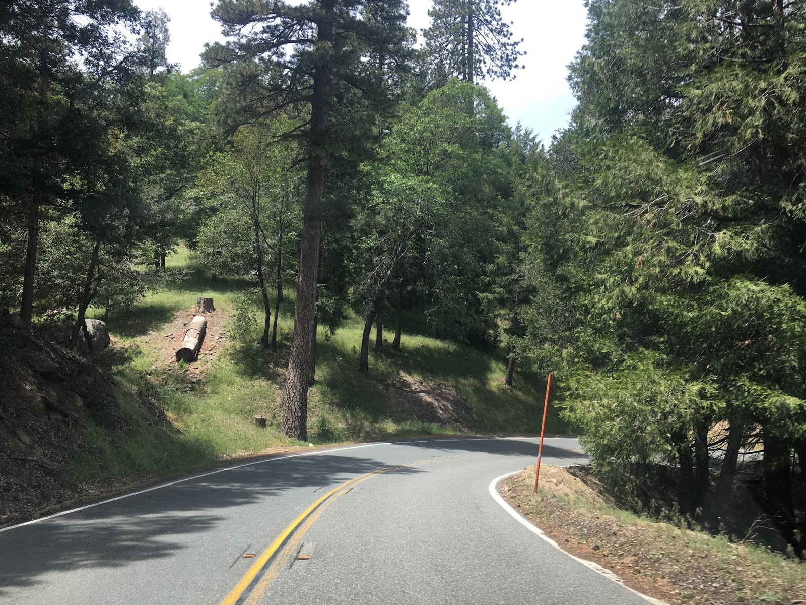
CA 138 west sharply descends through the San Bernardino Mountains before straightening out onto a two-lane expressway grade near Silverwood Lake.


Before Silverwood Lake was completed in 1971 the route of CA 138 west followed Dart Canyon Road into the Reservoir and emerged at the foot of Cedar Springs Dam at CA 173. The new alignment routed CA 138 on a two-lane expressway all the way west to CA 173 and includes an overlook of Silverwood Lake.


CA 138 west narrows to a conventional two-lane roadway through Horsethief Canyon.


CA 138 through Cajon Pass was recently realigned onto a new two lane expressway grade. The original route of CA 138 is located south of the new road grade and was razed as part of the realignment project.


Near the upper mouth of Crowder Canyon CA 138 west expands to a four-lane expressway.

Interestingly the original route of CA 138 from Forest Route 3N45 west to Crowder Canyon was part of the Cajon Pass Toll Road and 1914 alignment of the National Old Trails Road. Current I-15 doesn't use the actual Cajon Pass but rather Cajon Summit. The backstory of Cajon Pass is substantial and can be found in the blog below.
Cajon Pass road transportation history
CA 138 west approaches former US 66/91/395 at Wagon Train Road. Traffic is advised there is a monument for the Los Angeles-Salt Lake Road.


CA 138 west crosses I-15 and crosses all the rail lines of Cajon Pass approaching the Mormon Rocks. The Mormon Rocks were a landmark location that was used by travelers on the Mormon Road.


Beyond the Mormon Rocks CA 138 west enters a Safety Corridor.


There is a small monument to the Mormon Road near the boundary of San Bernardino National Forest.

CA 138 west exits San Bernardino National Forest and quickly approaches a junction with CA 2.


West of CA 2 the route of CA 138 is shown to be 37 miles from Palmdale.


CA 138 west passes through Pinion Hills before entering Los Angeles County.


Upon entering Los Angeles County CA 138 west passes through Llano.

CA 138 west enters a passing zone before crossing the California Aqueduct.


At Palmdale Road CA 138 west meets CA 18. Palmdale is signed as being 26 miles away on CA 138 west. At CA 18 the route of CA 138 begins to run westward on Pearblossom Highway.


West of CA 18 traffic on CA 138 is advised of gusty wind conditions for the next 23 miles.

At Largo Vista Road CA 138 west meets Signed County Route N4.


At 165th Street East CA 138 west traffic is advised there is access to Saddleback Butte State Park to the north.


Entering Pearblossom CA 138 west traffic is advised that the Devil's Punchbowl can be accessed via CR N6.


CA 138 west of Pearblossom continues through the Mojave Desert into Littlerock.


Littlerock is located only nine miles from the City Limits of Palmdale.


CA 138 west enters Palmdale and begins to swing northward. Pearblossom Highway splits west towards CA 14 and is often incorrectly marked on maps as CA 122. CA 122 was part of the 1959 definition of LRN 259 and was intended to be a highway connecting CA 14 northeast to CA 58.


CA 138 west heads into Palmdale on Fort Tejon Road and 47th Street East to a traffic circle at Palmdale Boulevard.


CA 138 west takes the third traffic circle exit onto Palmdale Boulevard.


CA 138 west on Palmdale Boulevard enters downtown Palmdale and meets former US 6 at Sierra Highway.


CA 138 west meets the Sierra Freeway and CA 14 west of downtown on Palmdale Boulevard. CA 138 west jumps onto a multiplex of CA 14 on the Antelope Valley Freeway whereas Palmdale Boulevard becomes CR N2.


CA 138 west/CA 14 north on the Antelope Valley Freeway multiplex into Lancaster.


At Avenue K there is signed access to Antelope Valley Indian Museum State Historic Park.


At Avenue J CA 138 west/CA 14 north meet CR N5. At Avenue I there is signed access to the Antelope Valley Poppy Reserve. Avenue I west of Lancaster is the original route of CA 138.


At Avenue D CA 138 west splits off the Antelope Valley Freeway and away from CA 14.


CA 138 west on Avenue D as noted above was intended to become CA 48, I-5 is signed as 35 miles away. CA 138 west progresses into Antelope Valley on a two-lane road configuration through a Safety Corridor. At 170th Street West there is signed access to the California State Poppy Reserve. At 245th Street West in Neenach CA 138 west meets it's original alignment.


CA 138 west of Neenach begins to ascend a curved grade approaching CR N2 at the Old Ridge Route.


CA 138 west of CR N2 is built directly over the path of Old US 99 on the Old Ridge Route to Gorman Post Road. Approaching Gorman Post Road CA 138 west passes by Quail Lake and expands to a freeway.


CA 138 west ends as a freeway at I-5.


The present alignment of CA 138 is 86 miles in length and travels in an east/west configuration. CA 138 is a notable highway given it closely follows the San Andreas Fault for much of it's alignment. CA 138 was one of the original run of 1934 Signed State Highways which was aligned on Legislative Route 59 between US 66 in Cajon west to US 99 near Tejon Pass. Interestingly east of Phelan it the original definition of CA 138 appears to have been intended to be co-signed with CA 2 to US 66 in Cajon Pass.
1934 Department of Public Works document annoucing the Signed State Highways
The multiplex of CA 2/CA 138 to Cajon Pass appears to have never been signed in-field. On the 1938 State Highway Map only CA 2 is seen meeting US 66/395 in Cajon Pass. CA 138 appears to end at CA 2 near Phelan.
1938 State Highway Map
LRN 59 was first adopted into the State Highway system as part of the 1919 Third State Highway Bond act between Baileys (a local near Gorman and the Old Ridge Route) east to Lancaster. This segment of LRN 59 closely aligned with the path of the historic Stockton-Los Angeles Road. In 1931 LRN 59 was extended east to LRN 31 in Cajon Pass and by 1933 it was extended to LRN 43 near Lake Arrowhead.
CAhighways.org on LRN 59
What would become CA 138 on LRN 188 was adopted into the State Highway system between LRN 59 and LRN 43 near Crestline in 1933.
CAhighways.org on LRN 188
Describing the alignment history of CA 138 is difficult given there has been so many shifts and abandoned ideas. That being the case I'll cover the alignment history in segments starting with CA 138 from I-5 east towards CA 14.
The original 1934 route of CA 138 from Gorman to Lancaster used the following route:
- Gorman Post Road east from US 99 in Gorman.
- Lancaster Road on modern CA 138 to Neenach.
- Modern 245th Street West from Neenach to Lancaster Road.
- Lancaster Road to Fairmont.
- Lancaster Road from Fairmont to 120th Street West.
- Avenue I to Sierra Highway/LRN 23 in Lancaster.
By 1956 CA 138/LRN 59 shown shifted onto Avenue D east from Neenach to US 6/LRN 23 north of Lancaster. This change can be observed by comparing the 1955 and 1956 State Highway Maps.
1955 State Highway Map
1956 State Highway Map
According to CAhighways.org a new proposed alignment of LRN 59 was legislatively defined running along what is modern Signed County Route N2 from CA 138 at Quail Lake southeast to Palmdale. Ironically this would have put another part of the Old Ridge Route back into the State Highway system but it ultimately never happened. CA 138/LRN 59 from Quail Lake east to US 6/LRN 23 was given a new LRN 267 designation which can be seen on the 1960 State Highway Map.
1960 State Highway Map
During the 1964 Highway renumbering the proposed route of LRN 59 between Quail Lake and Palmdale was assigned LRN 138. CA 138 to the north was assigned as part of LRN 48.
1964 State Highway Map
The path of CA 138 was eventually moved to a new freeway/expressway alignment which bypassed the Old Ridge Route alignment on Gorman Post Road. This new alignment appears to have been complete by 1967.
1967 State Highway Map
Eventually plans to route CA 138 along Signed County Route N2 were abandoned by 1996 according to CAhighway.org and the legislative definition of CA 48 was changed back to CA 138. The most recent studies by Caltrans suggest that CA 138 will largely become a four-lane expressway between I-5 and CA 14.
Previously I drove a large portion of the original route of CA 138 between the Old Ridge Route and Lancaster which can be found in the below blog:
Legend of the Ridge Route
Between Lancaster and Palmdale the route of CA 138 is presently multiplexed on the Sierra Freeway with CA 14. The original route of CA 138 would have multiplexed CA 7 on Sierra Highway until US 6 replaced it when it was extended to Long Beach in 1937. In 1964 US 6 was truncated to Bishop and CA 138 was multiplexed on the newly designated CA 14. On the 1967 State Highway Map the planned route of the Sierra Freeway appears between Lancaster and Palmdale. CA 138 was planned to use a bypass route of Palmdale which would have connected to the route described above on the corridor of CR N2.
1967 State Highway Map
The Sierra Freeway appears partially completed between Lancaster and Palmdale on the 1969 State Highway Map. The 1970 State Highway Map shows the Sierra Freeway closing in on Palmdale. The 1975 State Highway Map shows the Sierra Freeway complete with CA 14/138 multiplexed onto it.
1969 State Highway Map
1970 State Highway Map
1975 State Highway Map
Between Palmdale and Phelan the planned bypass route of Palmdale and new route of CA 138 to CA 18 appear on the State Highway Map. Ultimately neither segment of CA 138 was never built.
1967 State Highway Map
Between Phelan at CA 2 east to CA 18 in Crestline the route of CA 138 had one large change during the 1964 State Highway Renumbering. During the 1964 Renumbering CA 138 was routed over the 1958 CA 2 alignment east of Phelan via LRN 59 and LRN 188 to Crestline. This change can be seen by comparing the 1963 State Highway Map to the 1964 Edition.
1963 State Highway Map
1964 State Highway Map
Globally much of CA 138 east of Palmdale to I-15 in Cajon Pass is being considered for realignment. CAhighways.org offers information on current proposals for upgrading CA 138.
CAhighways.org on CA 138
With the historical alignment history of CA 138 (which is massive for a State Highway) out of the way I made my approach to the highway from CA 18 near Crestline.


CA 138 west from Crestline to Cajon Pass is part of the Rim of the World Scenic Byway of San Bernardino National Forest. From CA 18 the route of CA 138 west ascends the San Bernardino Mountains into Crestline.


CA 138 west takes a steep alignment out of Crestwood that is very difficult to follow unless you are closely reading the signage. On the north side of Crestline CA 138 westbound traffic is advised Silverwood Lake is 7 miles away and I-15 is located 21 miles away.


Traffic on CA 138 west of Crestline is given a length advisory due to the curvy grades on the next 5 miles ahead.


CA 138 west winds through the mountains before reaching and advisory for a 7% grade.


CA 138 west sharply descends through the San Bernardino Mountains before straightening out onto a two-lane expressway grade near Silverwood Lake.


Before Silverwood Lake was completed in 1971 the route of CA 138 west followed Dart Canyon Road into the Reservoir and emerged at the foot of Cedar Springs Dam at CA 173. The new alignment routed CA 138 on a two-lane expressway all the way west to CA 173 and includes an overlook of Silverwood Lake.


CA 138 west narrows to a conventional two-lane roadway through Horsethief Canyon.


CA 138 through Cajon Pass was recently realigned onto a new two lane expressway grade. The original route of CA 138 is located south of the new road grade and was razed as part of the realignment project.


Near the upper mouth of Crowder Canyon CA 138 west expands to a four-lane expressway.

Interestingly the original route of CA 138 from Forest Route 3N45 west to Crowder Canyon was part of the Cajon Pass Toll Road and 1914 alignment of the National Old Trails Road. Current I-15 doesn't use the actual Cajon Pass but rather Cajon Summit. The backstory of Cajon Pass is substantial and can be found in the blog below.
Cajon Pass road transportation history
CA 138 west approaches former US 66/91/395 at Wagon Train Road. Traffic is advised there is a monument for the Los Angeles-Salt Lake Road.


CA 138 west crosses I-15 and crosses all the rail lines of Cajon Pass approaching the Mormon Rocks. The Mormon Rocks were a landmark location that was used by travelers on the Mormon Road.


Beyond the Mormon Rocks CA 138 west enters a Safety Corridor.


There is a small monument to the Mormon Road near the boundary of San Bernardino National Forest.

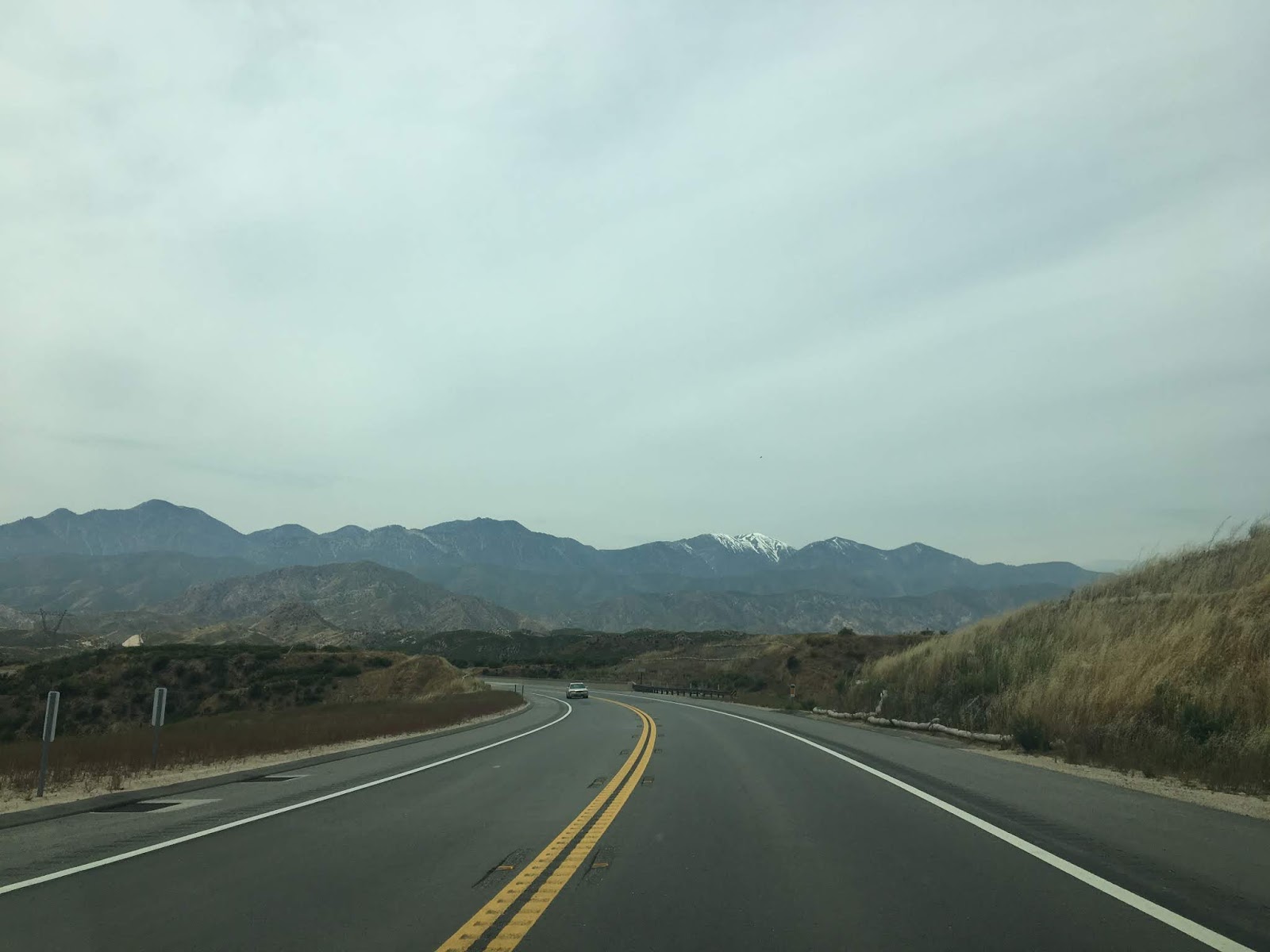
CA 138 west exits San Bernardino National Forest and quickly approaches a junction with CA 2.


West of CA 2 the route of CA 138 is shown to be 37 miles from Palmdale.


CA 138 west passes through Pinion Hills before entering Los Angeles County.


Upon entering Los Angeles County CA 138 west passes through Llano.

CA 138 west enters a passing zone before crossing the California Aqueduct.


At Palmdale Road CA 138 west meets CA 18. Palmdale is signed as being 26 miles away on CA 138 west. At CA 18 the route of CA 138 begins to run westward on Pearblossom Highway.


West of CA 18 traffic on CA 138 is advised of gusty wind conditions for the next 23 miles.

At Largo Vista Road CA 138 west meets Signed County Route N4.


At 165th Street East CA 138 west traffic is advised there is access to Saddleback Butte State Park to the north.


Entering Pearblossom CA 138 west traffic is advised that the Devil's Punchbowl can be accessed via CR N6.


CA 138 west of Pearblossom continues through the Mojave Desert into Littlerock.


Littlerock is located only nine miles from the City Limits of Palmdale.


CA 138 west enters Palmdale and begins to swing northward. Pearblossom Highway splits west towards CA 14 and is often incorrectly marked on maps as CA 122. CA 122 was part of the 1959 definition of LRN 259 and was intended to be a highway connecting CA 14 northeast to CA 58.


CA 138 west heads into Palmdale on Fort Tejon Road and 47th Street East to a traffic circle at Palmdale Boulevard.


CA 138 west takes the third traffic circle exit onto Palmdale Boulevard.


CA 138 west on Palmdale Boulevard enters downtown Palmdale and meets former US 6 at Sierra Highway.


CA 138 west meets the Sierra Freeway and CA 14 west of downtown on Palmdale Boulevard. CA 138 west jumps onto a multiplex of CA 14 on the Antelope Valley Freeway whereas Palmdale Boulevard becomes CR N2.


CA 138 west/CA 14 north on the Antelope Valley Freeway multiplex into Lancaster.


At Avenue K there is signed access to Antelope Valley Indian Museum State Historic Park.


At Avenue J CA 138 west/CA 14 north meet CR N5. At Avenue I there is signed access to the Antelope Valley Poppy Reserve. Avenue I west of Lancaster is the original route of CA 138.


At Avenue D CA 138 west splits off the Antelope Valley Freeway and away from CA 14.


CA 138 west on Avenue D as noted above was intended to become CA 48, I-5 is signed as 35 miles away. CA 138 west progresses into Antelope Valley on a two-lane road configuration through a Safety Corridor. At 170th Street West there is signed access to the California State Poppy Reserve. At 245th Street West in Neenach CA 138 west meets it's original alignment.


CA 138 west of Neenach begins to ascend a curved grade approaching CR N2 at the Old Ridge Route.


CA 138 west of CR N2 is built directly over the path of Old US 99 on the Old Ridge Route to Gorman Post Road. Approaching Gorman Post Road CA 138 west passes by Quail Lake and expands to a freeway.


CA 138 west ends as a freeway at I-5.


Comments