
National Park Wednesday; Tonto National Monument

Back in 2012 I visited Tonto National Monument which is located south of Arizona State Route 188 and Roosevelt in Gila County Arizona.


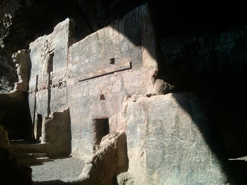
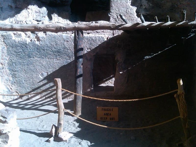
Tonto National Monument was designated in 1907 and preserves the cliff dwelling once occupied by the Salado people during the 13th Century to 15th Century.  Tonto National Monument consists of Lower and Upper ruins which are strewn above the Sonoran Desert landscape with various indicative Saguaros growing nearby.


The ruins of Tonto National Monument are located high above Salt River Valley and the waters of Roosevelt Lake.  Roosevelt Lake is formed by the nearby Roosevelt Dam impounding the Salt River near the junction AZ 88 and AZ 188.


Comments

Popular posts from this blog

Legacy of US Route 466 Part 5: Old Highway 58 through North Barstow

Old Highway 58 is a relinquished portion of what was once US Route 466 in the North Barstow area.  US Route 466 served the North Barstow area from 1933 until it was truncated to Baker during June 1964.  The segment would become the easternmost portion of California State Route 58 which remained as an active highway until 1996 when freeway south of downtown Barstow opened.  Old Highway 58 has numerous remaining Caltrans signs and more or less functions as an alternative northern bypass of downtown Barstow.   US Route 466 can be seen branching from US Route 91 in North Barstow on the 1953 United States Geological Survey Map. Part 1-Part 4 of the US Route 466 Legacy Series can be found below: Legacy of US Route 466 Part 1: California State Route 46 Legacy of US Route 466 Part 2: Tehachapi to Bakersfield  Legacy of US Route 466 Part 3: Morro Bay to Shandon via Rocky Canyon Legacy of US Route 466 Part 4: Hoover Dam Part 1; the history of US Route 466 and California State Route 58 in North B

Crescent City Connection (New Orleans, LA)

The Crescent City Connection is a massive dual-span steel truss bridge that spans the lower Mississippi River at downtown New Orleans, about 95 river miles upstream from the mouth of the great river at the Head of Passes Light. If counted as a single bi-directional highway bridge, the parallel spans combine to form the single busiest bridge on the Mississippi River and its importance as a linchpin in the region’s transportation network cannot be overstated. While there have been various schemes over the years to construct bridges downriver from Algiers Point, this bridge has been the southernmost bridge on the Mississippi River since its initial construction in the 1950s. The years immediately following the end of World War II were a transformational period in the history of New Orleans. Already one of the great economic and cultural centers of the American Deep South, it was recognized at this time that major changes and improvements to the city’s transportation infrastructure would b

Caliente-Bodfish Road

Caliente-Bodish Road is one of the finest driving roads in the southern Sierra Nevada range and has rich history. The approximately thirty-two-mile-long highway connects from Kern River Road in Bodfish south to Bena Road (former US Route 466) via Caliente siding. Caliente-Bodfish Road is a segment of Thomas Baker's stage road which facilitated overland travel to the claims of the Kern River Gold Rush. The Baker Stage Road was constructed during the 1860s-1870s and spanned from the outskirts of Caliente north to the Stockton-Los Angeles Road near Tailholt in Tulare County. The blog cover photo is from the nine-mile segment north of Caliente Creek Road which is known as the "Lion's Trail." Caliente-Bodish Road carries the internal designation of Kern County Road 483. Part 1; the history of Caliente-Bodfish Road Caliente-Bodish Road is a segment of what was Thomas Baker's stage road to Kern River Valley.  The Kern River Gold Rush began in 1853 and spurred devel