
This week I hiked much of what was the original alignment of the Big Oak Flat Road which is located to the north of the modern roadway. Unlike the original alignment of the Wawona Road the Old Big Oak Flat Road is surprisingly intact.
The complete history of the Big Oak Flat Road including the original alignment can be found on a 2002 report from the U.S. Department of Interior on the Old Big Oak Flat Road.
U.S. Department of the Interior on the Old Big Oak Flat Road
The Big Oak Flat Road began construction east from the mining community of Big Oak Flat in towards Yosemite Valley in 1869. The Big Oak Flat Road was constructed by the Chinese Camp and Yosemite Turnpike Company which had secured the franchise rights for a toll road to the Yosemite Grant (the designation prior to Yosemite National Park). By the summer of 1871 the Big Oak Flat Road reached the northern cliffs above Yosemite Valley which is when the Chinese Camp and Yosemite Turnpike Company ran out of funding. After the Chinese Camp and Yosemite Turnpike Company failed to comment on the the prospective future of the Big Oak Flat Road their franchise rights were turned over to the Coulterville and Yosemite Turnpike Company. The Coulterville and Yosemite Turnpike Company completed the Coulterville Road to Yosemite Valley in June of 1874.
In 1874 the Chinese Camp and Yosemite Turnpike Company went to the California Legislature to petition for reinstatement of their franchise rights to the Big Oak Flat Road. The California Legislature overruled the Yosemite Grant and reinstated the franchise rights of the Chinese Camp and Yosemite Turnpike Comapny to the Big Oak Flat Road. By July of 1874 the Big Oak Flat Road was constructed down to Yosemite Valley. The Big Oak Flat soon overtook Coulterville Road as the popular northern route into Yosemite Valley. The title of the Big Oak Flat Road was turned over to James Hutchings in 1878 who in turn founded the Big Oak Flat and Yosemite Turnpike Road Company in 1879.
In 1914 automobile traffic to Yosemite Valley was authorized by Yosemite National Park which led to the first cars traveling the Big Oak Flat Road. By 1915 Tuolumne County purchased the 30 mile Big Oak Flat Road to remove the tolls. Tuolumne County subsequently turned over the portion of the Big Oak Flat Road east to the Yosemite National Park Boundary to the California Division of Highways. The Division of Highways in turn made the Big Oak Flat Road to the Yosemite National Park boundary an extension of Legislative Route Number 40 ("LRN 40" and modern California State Route 120). The route of the Big Oak Flat Road within Yosemite National Park was turned over by Tuolumne County to the Federal Government .
CAhighways.org describes in detail the legislative extension of LRN 40 in 1915 to Yosemite National Park.
CAhighways.org on LRN 40
The 1918 Division of Highways State Map shows LRN 40 running east from modern junction of CA 49/CA 108 to Yosemite National Park via the Big Oak Flat Road.

In 1926 the National Park Service and Bureau of Public Roads drafted a new series of standards for access roads in National Parks. This led to a new routing of the Big Oak Flat Road being adopted to the south of the original route from Crane Flat to Yosemite Valley. The new alignment of Big Oak Flat Road was to be an all-year highway which grades much more gentle than the original alignment which had 16% descent into Yosemite Valley from Cascade Creek. Work on the New Big Oak Flat Road began in 1935 and was opened to traffic in 1940. The new Big Oak Flat Road utilized three tunnels and multiple bridges to descend to Yosemite Valley on a much lower grade.
In an August of 1934 Department of Public Works Guide
the Sign State Routes were announced. CA 120 was announced as being
signed east of Groveland through Yosemite National Park via the Tioga
Pass Road. CA 140 was announced as entering Yosemite National Park via
the El Portal Road and connecting to CA 120 through the park by way of
the Big Oak Flat Road.

The Old Big Oak Flat Road after 1940 was converted into a one-way scenic alternate from Crane Flat to Yosemite Valley. In 1943 a large rock slide made the Old Big Oak Flat Road inaccessible to cars and a subsequent slide in 1945 took out the 16% grade descending into Yosemite Valley. Given that a newer and much better Big Oak Flat Road had been opened in 1940 Yosemite National Park decided to abandoned much of the Big Oak Flat Road.
It wasn't until 1956/1957 that the New Big Oak Flat Road between
Evergreen Road and Crane Flat was opened to traffic. After the new
alignment of the Big Oak Flat Road between Evergreen Road and Crane Flat
opened the Old Big Oak Flat Road from the Carlon Day Use Area to
Tuolumne Grove was abandoned or turned into trails. The portion of the
Big Oak Flat Road from Crane Flat to the Tuolumne Grove became part of
the Tioga Pass Road. This second shift in the alignment of the Big Oak
Flat Road can be seen on the 1957 Division of Highways State Map.

This 1883 Topographical Map of Yosemite Valley shows the original alignment of the Big Oak Flat Road descending from Gentry Station near Cascade Creek eastward into Yosemite Valley. Coulterville Road can be seen south of the Big Oak Flat Road which would partially become the El Portal Road in the 20th Century.

The map of Mariposa County by the Division of Highways in 1935 below shows the original alignment of the Big Oak Flat Road ending just west of the 1933 El Captain Bridge on the north bank of the Merced River.

So with all the above in mind the below illustrations show the routing of the Old Big Oak Flat Road compared to the 1940 alignment. Much of the Old Big Oak Flat Road has been converted into trails, there is only one small section at Tamarack Flat that can still be driven


I began my search for the Old Big Oak Flat Road early in the morning heading into Yosemite National Park on the Wawona Road. West of the Wawona Tunnel there is an overlook of the El Portal Road and 1940 Big Oak Flat Road. While the grade of the Old Big Oak Flat Road can no longer be seen it isn't hard to envision it rising high above the 1940 alignment over the sheer granite cliff to Cascade Creek.


The grade of the Old Big Oak Flat above the 1940 Big Oak Flat Road can faintly be seen on the upper left section of this photo.

The first two tunnels of the 1940 Big Oak Flat Road are very apparent from the Wawona Road. It is easy to see why the grade of the 1940 Big Oak Flat Road is so much shallow with tunneling.


From the Wawona Tunnel View the grade of the Old Big Oak Flat Road is very apparent to the left. The 1943 and 1945 rock slides can easily be used as a landmark to spot the Old Big Oak Flat Road. The third photo below shows where a hairpin turn known as the "Zig-Zag" was located. The Zig-Zag was on the 16% grade of the Old Big Oak Flat Road.


I parked my at the 1933 El Captain Bridge which can be used as a landmark to find the Old Big Oak Flat Road in Yosemite Valley.


The Old Big Oak Flat Road in Yosemite Valley isn't signed but is very easy to find as it is located at Yosemite Valley Mile Marker 7. The Old Big Oak Flat Road is very apparent behind a vehicle access closure gate.


While the road grade is obvious there isn't much in the way of asphalt on the Old Big Oak Flat Road for a couple hundred yards.


The asphalt on the Yosemite Valley portion of the Big Oak Flat Road is surprisingly good until elevations start to rise. Its not difficult to envision pre-WWII cars coming downhill on excursions to Yosemite Valley with the sounds of vehicles nearby off to the south.


As the Old Big Oak Flat Road begins to ascend towards the 1940s rock slides the terrain is very damaged and strewn with debris.


End of the line came at the first rock slide which I believe is the one that occurred in 1943. The first rock slide looked like it could be climbed over but I didn't want to take the risk hiking by myself. There is an overlook beyond the first slide of Bridalveil Falls which is known as the Rainbow View. I turned around and headed back to my car to find other parts of the Old Big Oak Flat Road.


Descending the Old Big Oak Flat Road there was a fantastic view of El Captain. It must have been surreal to see such a view entering Yosemite Valley on a wagon.

After returning to my vehicle I drove out of Yosemite Valley on the El Portal Road to the junction with the Big Oak Flat Road. I always thought the MUTCD compliant US Route 395 signage was odd to see considering Caltrans still uses cut-out shields.


The ascent on the 1940 Big Oak Flat Road is pretty spectacular. The first of three tunnels is encountered very quickly.


The second tunnel quickly follows the first.

Between the second and third tunnels the 1940 Big Oak Flat Road crosses Cascade Creek in addition to Tamarack Creek. There is an overlook of the Merced River emptying out of Yosemite Valley.


The third tunnel on the 1940 Big Oak Flat Road is the longest and has a pull-out for the Half Dome View on the opposite end.


At junction with Foresta Road there is an overlook of Foresta and the Merced River Canyon on the 1940 Big Oak Flat Road. On the opposite side of the road there is a 4 mile trail head which heads east to the Old Big Oak Flat Road where it crossed Cascade Creek.


I did head about a mile east of Foresta Road which has a nice overlook of the entrance of Yosemite Valley.

My next destination was the Old Big Oak Flat Road which has been incorporated into a campground road and trail at Tamarack Flat. I turned east on the Tioga Pass Road which quickly intersects the Old Big Oak Flat in Tuolumne Grove. The Old Big Oak Flat Road continues west of the Tuolumne Grove as a trail before emerging onto Tuolumne Grove Road. Tuolumne Grove Road carries the Old Big Oak Flat Road alignment to what was CA 120 on Evergreen Road at the Yosemite National Park Boundary.

East of Tuolumne Grove a one mile section of the Old Big Oak Flat Road has been incorporated into the modern Tioga Road (the old Tioga Road is to the north) alignment. After a mile the Old Big Oak Flat Road splits north of the Tioga Pass Road and emerges as an access road to Tamarack Flat.


The Old Big Oak Flat Road can be driven for about three miles from the Tioga Road to the Tamarack Campground. The Old Big Oak Flat has a recently repaved surface but it is extremely narrow with a couple hairpins.


The Old Big Oak Flat Road crosses Tamarack Creek within the Tamarack Camp ground before becoming the Tamarack Trail. There is an old culvert which serves as a nice demonstration of what crossings on the Old Big Oak Flat Road would have looked like. At the start of the trail head it is 2.4 miles eastward to Cascade Creek where the junction with the trail to Foresta described above is located.


The bridge at Cascade Creek along the Old Big Oak Flat Road was apparently destroyed in the winter of 1964-65. The Old Big Oak Flat Road east of the Tamarack Campground to Cascade Creek was closed to traffic in 1984. The Old Big Oak Flat Road between Tamarack Campground to Cascade Creek is in surprisingly good shape considering it has not been maintained in over three decades. That said, there are several washouts where culverts used to be located. It is apparent time and lack of maintenance is taking it's toll on the Old Big Oak Flat Road regardless of decent asphalt quality. I hiked about 1.5 miles towards Cascade Creek before turning around for Tamarack Flat.


Considering how much of the Old Big Oak Flat Road is left I find it surprising that there isn't more of an effort by Yosemite National Park to promote it as a historical analog of travel to Yosemite Valley in the 19th Century. Much of the history of the Old Wawona Road is preserved in the Pioneer Yosemite History Center but there is nary a mention that I could find of the Old Oak Flat Road. The Tioga Road alignments seem to be much more well known given that CA 120 connected on both ends. Either way there seems to be a somewhat missed opportunity to promote the history of transportation to Yosemite National Park a little better in my opinion.
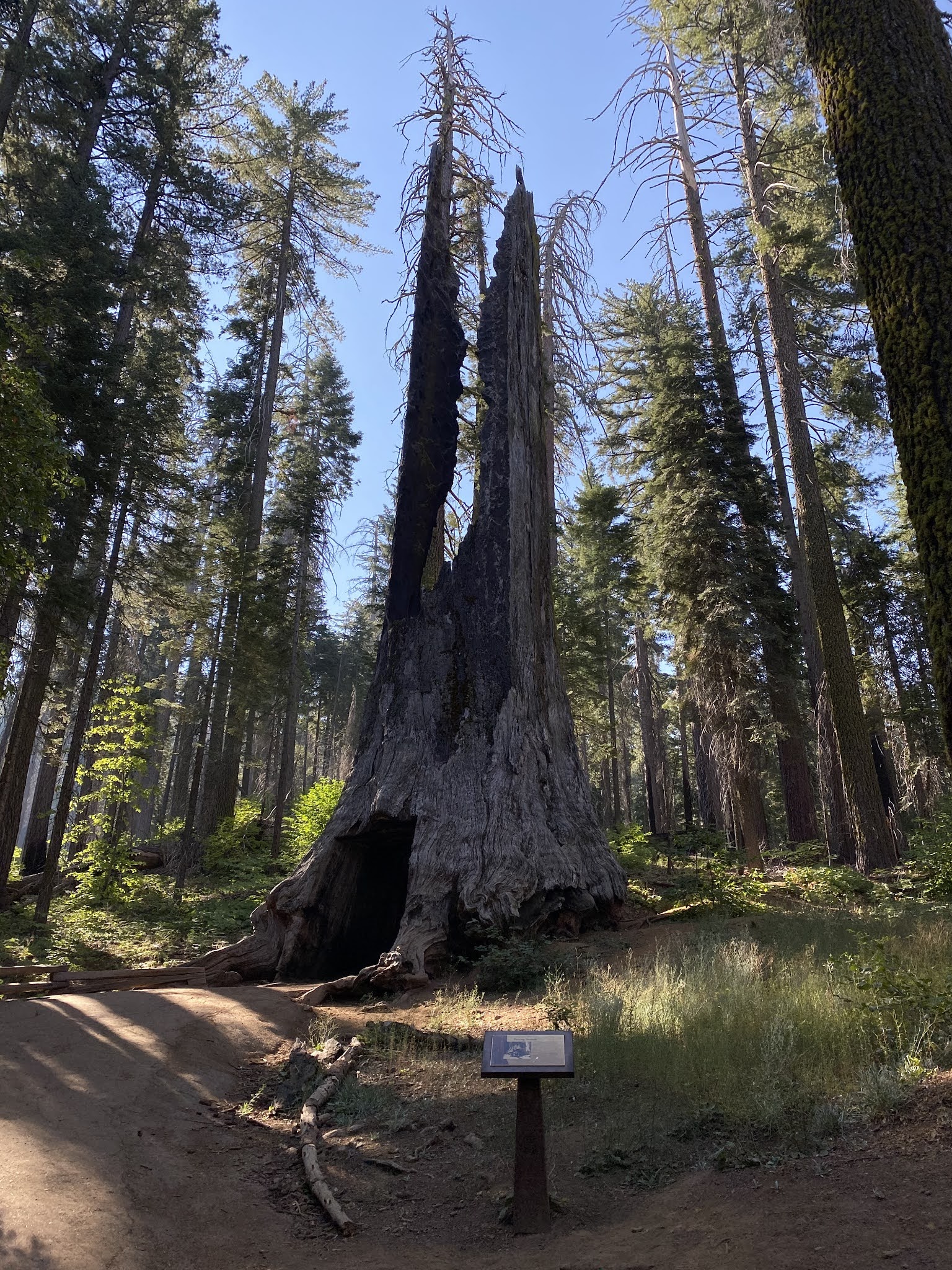
Update 9/12/20; The week prior to Labor Day I returned to Yosemite and hiked the Old Big Oak Flat Road to the Tuolumne Grove. During my hike I passed through the Dead Giant Tunnel Tree. The Dead Giant was carved out in 1878 during the heyday of wagon stages on the Big Oak Flat Road.


California State Route 140 in the Merced River Canyon (the El Portal Road)

Comments