US Route 95 within California exists within San Bernardino County and Riverside County. US Route 95 within California is approximately 130 miles factoring multiplexes along Interstate 10 and Interstate 40. US Route 95 in California begins at the Arizona state line along the Colorado River near Blythe in Riverside County. US Route 95 follows the general course of the Colorado River north through the Sonoran Desert to the Mojave Desert towards Needles of San Bernadino County. US Route 95 enters Nevada north of Interstate 40 and the historic alignment of US Route 66. US Route 95 was extended to Blythe, California during July 1939. Upon US Route 95 entering California during 1939 it overlapped and deleted much of the original California State Route 195. US Route 95 was extended from Blythe into Arizona during June 1960.
Part 1; the history of US Route 95 in California
The corridor of modern-day US Route 95 in California first came to prominence during the run-up to the creation of the US Route System. What ultimately became the US Route System was first discussed by the American Association of State Highway Officials (AASHO) during their annual 1924 meeting. Ultimately AASHO recommended to the Department of Agriculture to work with the States to develop a system of Interstate Highways to replace the many Auto Trails in use. The Joint Board on Interstate Highways was ultimately commissioned by the Department of Agriculture and the Bureau of Public Roads during March of 1925. The Joint Board on Interstate Highways first met in April of 1925 and decided on the new interstate road network would be known as "U.S. Highways."
During the drafting phases of the US Route System in 1925 the Joint Board on Interstate Highways ultimately decided several facets of what would become the system numbering convention:
- Odd one or two-digit numbers would denote a north/south route.
- Even one or two-digit numbers would denote an east/west route.
- X1 numbers would denote major north/south routes.
- X0 numbers would denote major east/west routes.
- Spur highways of one or two-digit routes would be assigned a third digit.
- Odd numbers would begin at 1 on the East Coast and ascend westward.
- Even numbers would begin at near the Canadian Border at 2 and ascend southward.
- The numbering of the US Route System would ultimately infer a position within the country to aid navigation.
By October of 1925 the Joint Board on Interstate Highways submitted a final report to the Secretary of the Department Agriculture. Part of the final report regarding the US Route System would be a list of routing points for all purposed US Routes. The full list of the US Routes originally submitted in October of 1925 can be viewed on the link below:
Report of Joint Board on Interstate Highways; October 30th, 1925While the US Route System submitted in October of 1925 were fairly close to what was implemented officially in November of 1926 there was some significant differences. Regarding US Route 91 the routing points were clear aside from the southern terminus in the Mojave Desert of California. In the October 1925 report submitted by the Joint Board on Interstate Highways US Route 91 is shown simply as ending at US Route 60 (US Route 66 in the final US Route System).
The US Route System within California was approved by California Highway Commission with no changes recommended which can be seen in the January 1926 California Highways & Public Works. US Route 91 was stated to enter California and end near Needles. This corridor would in time be established as a component of US Route 95.


The planned route of US Route 91 south from Great Falls, Montana to Las Vegas, Nevada is very clear in the 1925 Report. South of Las Vegas the routing of US Route 91 was at best open to interpretation. Ultimately two existing roads south of Las Vegas to what was planned as US Route 60 were immediately available; the Los Angeles-Salt Lake Road towards Daggett or the Arrowhead Trail which was aligned directly south into California to Bannock. The Arrowhead Trail was multiplexed with the National Park-to-Park Highway and Evergreen National Highway which can be seen on the 1924 Rand McNally Map of California. Below the Arrowhead Trail is listed as "18," the National Park-to-Park Highway as "64" and Evergreen National Highway as "20."

The Arrowhead Trail was an Auto Trail which was plotted out in 1915 when Charles H. Bigelow (race car driver and promoter) drove the entire route planned route between Salt Lake City and Los Angeles. The Arrowhead Trails Association would incorporate as an Auto Trail organizer based out of Los Angeles in December of 1916. The Arrowhead Trail largely followed the path of the Los Angeles-Salt Lake Road but detoured significantly south of Las Vegas via Nevada State Route 5 ("NV 5") towards Bannock. By 1920 the "Silver Lake Cutoff" of the Arrowhead Trail was proposed as a means of to saving 90 miles by connecting the highway from Las Vegas directly southwest to Daggett. The Silver Lake Cutoff was similar to the previous Los Angeles-Salt Lake Road but followed a more northern path to utilize the Tonopah & Tidewater Railroad sidings of Silver Lake as a waypoint. This new routing of the Arrowhead Trail via the Silver Lake Cutoff was ultimately paved with oiled earth in 1925 by San Bernardino County.
As the early US Route System was still in the works it appeared that US Route 91 would ultimately follow Nevada State Route 5 via the National Park-to-Park Highway and Evergreen National Highway to US Route 60 near Bannock. This 1925 Rand McNally Highway Map shows the projected route of US Route 91 entering California via Nevada State Route 5 on the National Park-to-Park Highway and Evergreen National Highway to a southern terminus at US Route 60 in Bannock.
Ultimately what drove the decision to route US Route 91 via the Arrowhead Trail to Daggett appears to be the extension of Legislative Route 31 ("LRN 31") by the California Legislature. According to CAhighways.org LRN 31 was first adopted as a State Highway during the 1916 Second State Highway Bond Act between the San Bernardino County line northeast to Barstow. In 1925 the Legislature approved an extension of LRN 31 from Barstow to the Nevada State Line.
The new extension of LRN 31 from Barstow to the Nevada State Line appears as a planned Legislative Act Road on the 1926 California Highway Commission Map.
The 1927 National Map Company Sectional Map shows US Route 91 entering California via Nevada State Route 6 southwest over what had been the Arrowhead Trail. US Route 91 is shown traversing through the Mojave Desert via; Francis Springs, Silver Lake, and Bitter Spring headed southwest to Daggett and US Route 66.
During 1933 the future corridor of US Route 95 in California was added to the State Highway System as LRN 146. LRN 146 given the following definition:
- The Imperial/Riverside County line near Palo Verde to LRN 64 (US Route 60) near Blythe
- LRN 64 near Blythe to LRN 58 (US Route 66) near Needles
- LRN 58 W of Needles northerly to the California-Nevada state line
LRN 146 can be seen for the first time on the 1934 Division of Highways Map.
The entirety of LRN 146 was announced as being assigned California State Route 195 in the
August 1934 California Highways & Public Works. It is unclear if the number "195" was intended to be a place holder for a future extension of the US Route 95 family of highways into California.


California State Route 195 multiplexed US Route 66/LRN 58 from the vicinity of Kleinfelter east to Needles. Within Needles US Route 66 and California State Route 195 multiplexed through the community via Needles Highway, Front Street, G Street and Broadway Street. California State Route 195 split from US Route 66 via LRN 146 towards Blythe south of Needles at Parker Junction. California State Route 195/LRN 146 can be seen in detail on the
1935 Division of Highways Map of San Bernardino County.
California State Route 195/LRN 146 can be seen in detail on the
1935 Division of Highways Map of Riverside County. California State Route 195/LRN 146 can be seen entering Blythe via Intake Boulevard and intersecting US Route 60-70/LRN 64 at Hobson Way. California State Route 195 multiplexed US Route 60-70 west through Blythe and branched south towards the Imperial County line near Palo Verde via Neighbours Boulevard.


In a letter dated October 4, 1938, the Nevada State Highway Engineer requested information from the AASHO Executive Secretary pertaining to a 1937 request to extend US Route 95 through Nevada to Blythe, California. The origin point for the proposed extension of US Route 95 is shown to be the Idaho Oregon Nevada Highway (I.O.N. Highway #456) at McDermitt at the Oregon/Neveda state line. The AASHO Executive Secretary replied on October 8, 1937, indicating that the Oregon Department of Transportation stated I.O.N. #456 was not ready to facilitate modern automotive travel. The AASHO Executive Committee's opinion was to hold off on the extension of US Route 95 until I.O.N Highway #456 was completed in Oregon.

On May 20, 1939, the Nevada State Highway Engineer again petitioned the AASHO Executive Committee to extend US 95 through Nevada. The Nevada State Highway Engineer noted Nevada State Route 8 had been fully paved from Winnemucca to the Oregon State Line since 1936 and was ready to be assigned as US Route 95 despite I.O.N. Highway #456 not being completed.
The Nevada State Highway Engineer's letter was met with a reply by the AASHO Executive Secretary on May 24, 1939. The Executive Secretary stated once notification of the completion of I.O.N. Highway #456 was received from the Oregon Department of Transportation the AASHO Executive Committee would likely take action to extend US Route 95.
A letter dated June 2, 1939, from the AASHO Executive Secretary to the State Highway engineers of; California, Nevada, Oregon and Idaho noted the proposed alignment of US Route 95 south to Blythe, California. A separate letter to the Nevada State Highway Engineer notes that a last-minute request was made to extend US Route 93 south of Las Vegas to the California State Line via Searchlight over Nevada State Route 5 instead of US Route 95.
A letter dated June 10, 1939, by the AASHO Executive Secretary to the President of the AASHO states that the Nevada State Highway Engineer attempted to get US Route 95 into Nevada before the completion of I.O.N. Highway #456 under the pretenses that a like interim measure was permitted for the extension of US Route 6 to California. I.O.N Highway #456 is noted to have an anticipated completion sometime during 1940.

The AASHO Executive Secretary advised the Highway Engineers of California, Nevada, Oregon and Idaho in a letter dated July 7, 1939, that the AASHO Executive Committee approved the extension of US Route 95 to Blythe, California. US Route 95 absorbed the existing routing of California State Route 195/LRN 146 from the Nevada State Line south to US Route 60-70/LRN 64 at Hobson Way in Blythe. Upon the extension of US Route 95 into California the original California State Route 195 was deleted. The California State Route 195 number was reassigned to the former routing of US Route 60-70 via a spur of LRN 64 in Box Canyon.
Storm damage to US Route 95/LRN 146 north of Blythe towards Needles was featured in the
October 1939 California Highways & Public Works. The photo stub mistakenly notes the highway as "US Route 195."

US Route 95 can be seen terminating at US Route 60-70 in Blythe on the
1940 Division of Highways Map.

On June 29th, 1956, the Federal Highway Aid Act of 1956 was signed into law on the Federal Level. The Federal Highway Aid Act of 1956 was the genesis point of the Interstate Highway System. US Route 66-95 between Kleinfelter and Needles was slated to multiplexed along Interstate 40.
The January/February 1958 California Highways & Public Works featured the opening of an 8-mile segment of Interstate 40/US Route 66/LRN 58 east of Needles. The new freeway segment opened to traffic on October 15, 1957, and shifted the branching point of the US Route 66/US Route 95 to Broadway Street. LRN 146 was extended from Parker Junction north towards Broadway Street in Needles.


US Route 95 was approved to be extended from Blythe to the Mexican border at San Luis, Arizona, by the AASHO Executive Committee on June 28, 1960. US Route 95 from Intake Boulevard multiplexed US Route 60-70 and planned Interstate 10 along Hobsonway to the Colorado River and Arizona state line. The extension of US Route 95 to the Mexican border was desired by the Arizona Highway Department and was not objected by the Division of Highways.


The
May/June 1961 California Highways & Public Works announced US Route 66-95/LRN 58 in Needles had been recently converted via cooperative project to four lanes within the city. US Route 66-95 was shifted to an interim alignment which utilized an extension of Broadway Street which bypassed G Street and Front Street. The interim alignment of US Route 66-95 was intended as a stop-gap measure in anticipation of Interstate 40 being constructed as a bypass.
The
November/December 1961 California Highways & Public Works announced the new Colorado River Bridge carrying US Route 60-70-95/Interstate 10 into Arizona east of Blythe was recently completed. Construction costs for the new Colorado River Bridge were shared by the states of California and Arizona. The new span replaced the earlier Colorado River Truss Bridge which had been completed during 1928.
US Route 70 was approved to be truncated from Los Angeles to US Route 95 in Blythe by AASHO on August 26, 1963. The truncation of US Route 70 left only US Route 60 and Interstate 10 as the only signed routes through Coachella Valley on LRN 26. All the Legislative Route Numbers would be dropped as part of the 1964 State Highway Renumbering.


The AASHO Executive Committee approved US Route 60 to be truncated from downtown Los Angeles to US Route 95 in Blythe on October 2, 1965.
On June 24, 1969, AASHO approved an Arizona Highway Department request to truncate US Route 70 from the California State Line to Globe. The truncation of US Route 70 removed it from the multiplex of US Route 95-60 and Interstate 10 between Blythe to Quartzsite, Arizona.
Interstate 10 was constructed through Blythe during the early 1970s as well as Interstate 40 through Needles.
According to USends.com US Route 66 was truncated to US Route 95 in Needles in 1972 following the completion of Interstate 40 in the Bristol Mountains. US Route 95 can be seen on the 1975 Caltrans Map concurrent with Interstate 40 from the vicinity of Kleinfelter/Java to Needles. The same map shows US Route 95 entering Arizona along concurrent with Interstate 10 east of Blythe. The map does not display the terminus of US Route 60 which formally was still located at US Route 95 in Blythe.


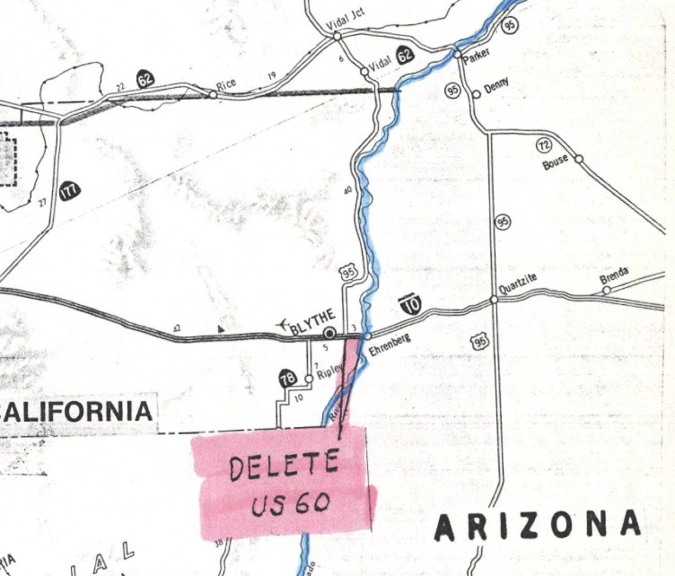
AASHTO (now the American Association of State Highway Transportation Officials) deferred a Caltrans request to truncate US Route 60 between US Route 95 in Blythe and the Arizona state line on June 29, 1982. The request to truncate US Route 60 from Blythe was deferred pending a like application from Arizona. Caltrans noted in their request that US Route 60 was not signed along US Route 95/Interstate 10 east of Blythe to the Arizona state line.


US Route 60 was officially deleted in California during their
November 1982 meeting. US Route 60 was truncated from US Route 95 in Blythe to Interstate 10 near Brenda, Arizona.
Part 2; scenes along US Route 95 in California
US Route 95 northbound enters California multiplexed with westbound Interstate 10 from Arizona via the 1961 Colorado River bridge. Interstate 10 and US Route 95 pass through a state line Agriculture Stations upon entering California. US Route 95 splits from Interstate 10 in Blythe via Intake Boulevard.
Below California State Route 62 eastbound can be seen approaching US Route 95 at Vidal Junction.
A historic US Route 66 shield can be seen along what as the multiplex of US Route 66-95 on G Street in Needles.
A highlight of the historic alignment of US Route 66-95 in Needles is the El Garces Hotel. The El Garces Hotel is a Harvey House built in 1908 to serve railroad passengers. The El Garces Hotel was recently restored and reopened as a transportation facility in 2014.
Below southbound US Route 95 can be seen approaching San Bernardino County Route 66 near Bannock siding. This junction was the original intended terminus of US Route 91 as noted in Part 1.


Comments