
During the winter of 2023 California experienced one of the wettest seasons in recent decades. Enough snow and water were deposited into the Sierra Nevada Mountains that the runoff was enough to partially reform Tulare Lake within San Joaquin Valley. Tulare Lake was once the largest lake west of the Mississippi River by surface area. Tulare Lake has been largely dried for the past century due to irrigation divisions and upstream impoundments. This blog will examine the history of Tulare Lake and its recent return. Pictured as the blog cover is Tulare Lake from 19th Avenue in Kings County during early May 2023. Tulare Lake can be seen near its maximum extent below on the 1876 P.Y. Baker Map of Tulare County.

Part 1; the history of Tulare Lake
Tulare Lake is the largest remnant of Lake Corcoran. Lake Corcoran once covered much of the entire Central Valley due to being it being located at a in natural low point from where mountain run-off would accumulate. Lake Corcoran is thought to have formed approximately 760,000 years ago and naturally drain into Monterey Bay. Approximately 600,000 years ago the waters of Lake Corcoran over topped which carved a new outlet via Carquinez Strait. and San Francisco Bay. The draining of Lake Corcoran left several remnant lakes in southern San Joaquin Valley which were connected by the Kern River Slough. Aside from Tulare Lake the other large remnants of Lake Corcoran included Buena Vista Lake and Kern Lake.
At it's maximum extent Tulare Lake was once approximately 700 square miles. The Tulare Lake basin is located at a natural low point of San Joaquin Valley which is fed by the many rivers draining out of the Sierra Nevada Mountains. While large in surface area the waters of Tulare Lake were shallow which left it's size greatly dependent on winter runoff. Tulare Lake was fed from the Sierra Nevada Mountains prominently by the Kern River Slough, White River, Tule River and Kings River. Numerous additional creeks, sloughs and runoff from the Coast Ranges also contributed water to the Tulare Lake basin.
During the wettest of years Tulare Lake would backflow when it's waters reached 207-210 feet above sea level. The backflow of Tulare Lake spilled into the Kings River and Fresno Slough towards the San Joaquin River. Tulare Lake also had numerous islands which could be found near its southern shores.
The shores of Tulare Lake prior to the arrival of Europeans were home to numerous Yokut tribes. The Yokut used Tulare Lake and the numerous surrounding wetlands for fishing. The lands around Tulare Lake were home to numerous animals which were hunted by the Yokut. The species Tule Elk once thrived around the waters of Tulare Lake before almost being hunted to extinction. At the time of European contract, the Wowol, Tachi and Chunut tribes occupied the lands around Tulare Lake.
During 1773 in the era of Las Californias an expedition party led by Spanish Captain Pedro Feges explored southern San Joaquin Valley. The Spanish found the wetlands of Southern San Joaquin Valley to be difficult to navigate due to the marshy conditions.
Given that the Spanish Missions were located along the coast the majority of travel in Las Californias was along the road known as El Camino Real. Travel into the interior of Las Californias through San Joaquin Valley was a difficult prospect given the lack of civilization and more so due to the Tule Marshes of Kern Lake, Buena Vista Lake, Tulare Lake and the San Joaquin River. That said, travel inland to the San Francisco Bay Area from Los Angeles was desired by some which led to the creation El Camino Viejo which was in common use as early as 1780. El Camino Viejo is sometimes called "El Camino Viejo Los Angeles" and simply translated as "The Old Road" or "The Old Road to Los Angeles."
During the Mexican period of Alta California and early statehood of California the Tulare Lake basin was still largely avoided by travelers. During 1833 an epidemic is reported to have ravaged the Yokut tribes along the shores of Tulare Lake. Much the early American settlement of California was centric to the northern foothills of the Sierra Nevada Mountains where the 1849 Gold Rush had begun.
By 1853 gold claims were struck along the Kern River which led to the Kern River Gold Rush. By the Kern River Gold Rush, the entirety of the Sierra Nevada Mountains had become attractive for prospectors looking to make money on the new mining claims. El Camino Viejo being routed west of the Tulare Lake watershed was suddenly no longer a viable route for the majority of travelers through San Joaquin Valley. A new route from Stockton to Los Angeles following the Sierra Nevada Foothills along the eastern edge of San Joaquin Valley was created and came to be known as the Stockton-Los Angeles Road. The foothills of the Sierra Nevada Mountains also served a dual purpose as it was easier to navigate by road due to the narrow water crossings as opposed to the marshy lands in San Joaquin Valley.
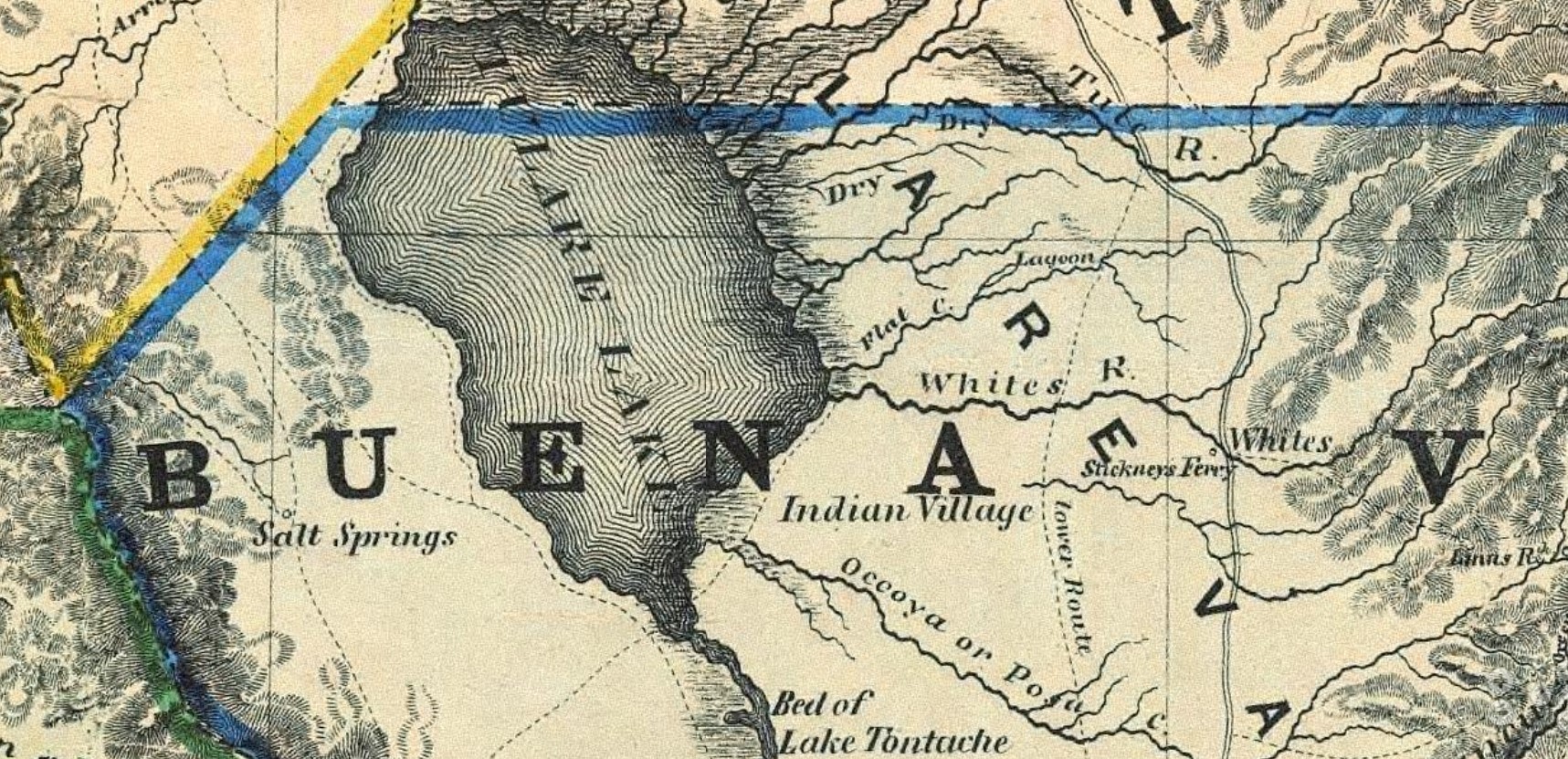
The 1857 Britton & Rey's Map of California shows all the major routes traversing the mountains between San Fernando Valley and San Joaquin Valley. Highlighted below the Cuddy Canyon alignment of El Camino Viejo, the path over Old Tejon Pass and the primary route of the Stockton-Los Angeles Road over Tejon Pass can be seen. El Camino Viejo can be seen following the shores of Kern Lake and Buena Vista Lake. The route of El Camino Viejo and Stockton-Los Angeles Road south of Antelope Valley took an identical path through San Francisquito Canyon to San Fernando Valley.

El Camino Viejo can be seen following the shoreline of Tulare Lake with numerous branches dipping west into the Coast Ranges. The Stockton-Los Angeles Road can be seen far to the east crossing rivers in the foothills of the Sierra Nevada Mountains. Much of Tulare Lake is shown to be in the sort lived Buena Vista County whereas the northern shore is shown to be in Tulare County. Buena Vista County existed from 1855 to 1859 and ultimately folded back into Tulare County.
During the late 1860s through early 1870s the corridor of the Southern Pacific Railroad was developed through San Joaquin Valley towards Tehachapi Pass. The development of the Southern Pacific Railroad brought forms of water diversion controls in San Joaquin Valley. The Southern Pacific Railroad spurred development of numerous communities via subdivided land parcels. Development of the Southern Pacific Railroad triggered a railroad and agriculture boom in San Joaquin Valley which would peak during the 1880s. From 1850 through 1878 the waters of Tulare Lake back flowed into Fresno Slough nineteen times. Since 1879 the waters of Tulare Lake have never again back flowed.
Tulare Lake can be seen near its maximum extent below on the 1876 P.Y. Baker Map of Tulare County. Many of the shallower land parcels on all sides of Tulare Lake are shown to have already been sold to private agricultural developers. Much of Tulare Lake is shown to occupy western Tulare County with small portions entering Kern County and Fresno County.
The northern extent of Tulare Lake is shown reaching into Fresno County near the grounds of what is now Naval Air Station Lemoore. The community of Lemoore can be seen near the northern shore of Tulare Lake within Tulare County. Lemoore was founded during 1871 by Dr. Lovern Lee Moore. The Southern Pacific Railroad tracks shown crossing the northern extent of Tulare Lake were developed in the mid-1870s and are still present west of Lemoore. The now largely dry Summit Lake can be found along modern Grangeville Bypass Road.

The Broken Mountains can be seen on the western shore of Tulare Lake near Kettlemans Plains. This range is known in modern times as the Kettleman Hills and modern Kettleman City occupies what was once the western shore of Tulare Lake.

The Pelican Islands, Bird Island and Root Island can be seen on the southern shore of Tulare Lake. Root Island alternatively was known as Hog Island or Atwell's Island. During the early 1850s Root Island would was the location of a Wowol village known as Chawlowin. Allen Atwell would later purchase Root Island and introduce hogs to it after the forcible removal of the Wowol. Root Island is where the present-day community of Alpaugh would begin to develop after being subdivided during 1905. The islands of Tulare Lake today are part of a high ground formation known as the Sand Ridge.

The future town site of Corcoran can be seen west of Tipton submerged under the northeast corner of Tulare Lake. Much like Alpaugh the lands that now comprise Corcoran were subdivided during 1905 along the Atchison, Topeka and Santa Fe Railroad.

Tulare Lake would begin to rapidly shrink after 1878 due to water being diverted for irrigation use. Naturalist Gustav Eisen is known to have been part of an expedition which crossed Tulare Lake via steamboat during 1878. A greatly diminished Tulare Lake is displayed on the 1892 T.H. Thompson Map of Tulare County. The northern shore of Tulare Lake is shown far south of Lemoore and no islands are shown present on the southern shore. On March 22, 1893, Kings County would split from western Tulare County along with almost the entirety of the Tulare Lake basin.


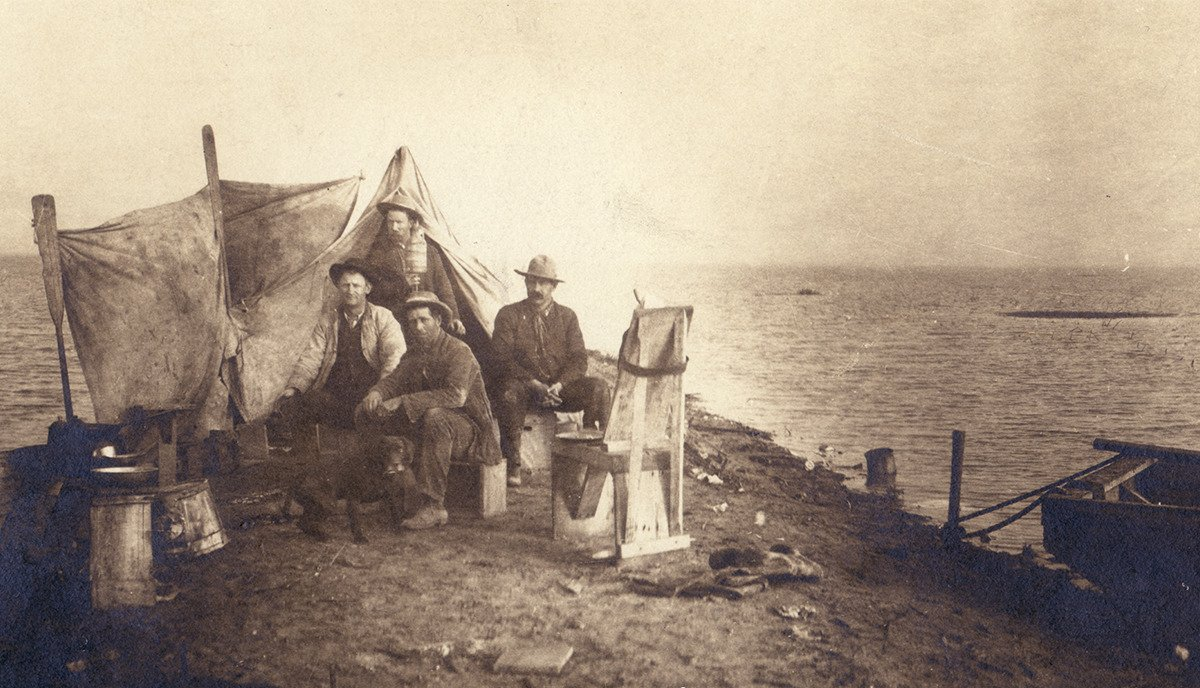
This photo depicts a camping expedition along the shores of Tulare Lake in 1880. This photo is reportedly one of two known photos which depict Tulare Lake at its maximum extent. The physical photocopy is housed at the Sarah A. Mooney Memorial Museum in Lemoore.
Tulare Lake would completely dry for the first time during 1898. Despite drying the waters of Tulare Lake would often return as there was no true flood control measures in the Sierra Nevada Mountains. Despite semi-regular flood events the bottom of Tulare Lake would continue to be developed for agricultural use. During 1921 the J.G. Boswell Company would be established as in Corcoran and begin cultivation of cotton on land parcels purchased at the Tulare Lake basin.
During 1934 Santa Rosa Rancheria was established as a Tachi-Yokut reservation south of Lemoore. Santa Rosa Rancheria was developed upon forty acres of farmland which was once part of the northern shore of Tulare Lake. The 1935 Division of Highways Map of Kings County depicts the Tulare Lake basin as being dry. Modern day 20 1/2 Avenue and 19th Avenue can be seen jutting south from Stratford into the Tulare Lake basin. Following a flood during 1938 Tulare Lake partially refilled. Tulare Lake was used as an auxiliary seaplane base under the command of Naval Air Station Alameda in World War II.

Modern day Utica Avenue can be seen crossing the southern half of the Tulare Lake basin from 25th Avenue east towards the vicinity of Alpaugh.
Floods into the Tulare Lake basin would become less frequent as dams were installed in the Sierra Nevada Mountains. Isabella Dam along the Kern River was completed during 1953 by the Army Corps of Engineers. Isabell Dam would be followed by Pine Flat Dam along the Kings River during 1954. Success Dam would impound the Tule River east of Porterville by 1961 which was followed by the Terminus Dam on the Kaweah River by 1962.
Prior to 2023 the last time any portion of Tulare Lake reformed was during 1997. The winter of 2023 brought a series of atmospheric rivers brought numerous storms which led to far larger than normal snowpack in the Sierra Nevada Mountains. The amount of water coming out of the Sierra Nevada Mountains led to large releases at Lake Success which led to the reformation of Tulare Lake between the communities of Stratford and Corcoran. The communities of Corcoran, Alpaugh and Allensworth have experienced flooding as the Tule River emptied into the Tulare Lake basin.
Much of the flooded lands west of Corcoran are parcels owned by J.G. Boswell Company. The company has been accused in some news outlets of not allowing water to drain into the Tulare Lake bottom. The company was ordered during the past March by the Kings County Board of Supervisors to cut a levee.
The waters of Tulare Lake by some accounts are predicted to continue to rise by another five to ten feet during the summer of 2023. As of the publishing of this blog some estimates place the size of Tulare Lake slightly above 100 square miles. The water already in Tulare Lake is not anticipated to fully evaporate or sink for another 18 to 24 months. Corcoran and the State of California are presently raising levees to prevent the city from flooding.
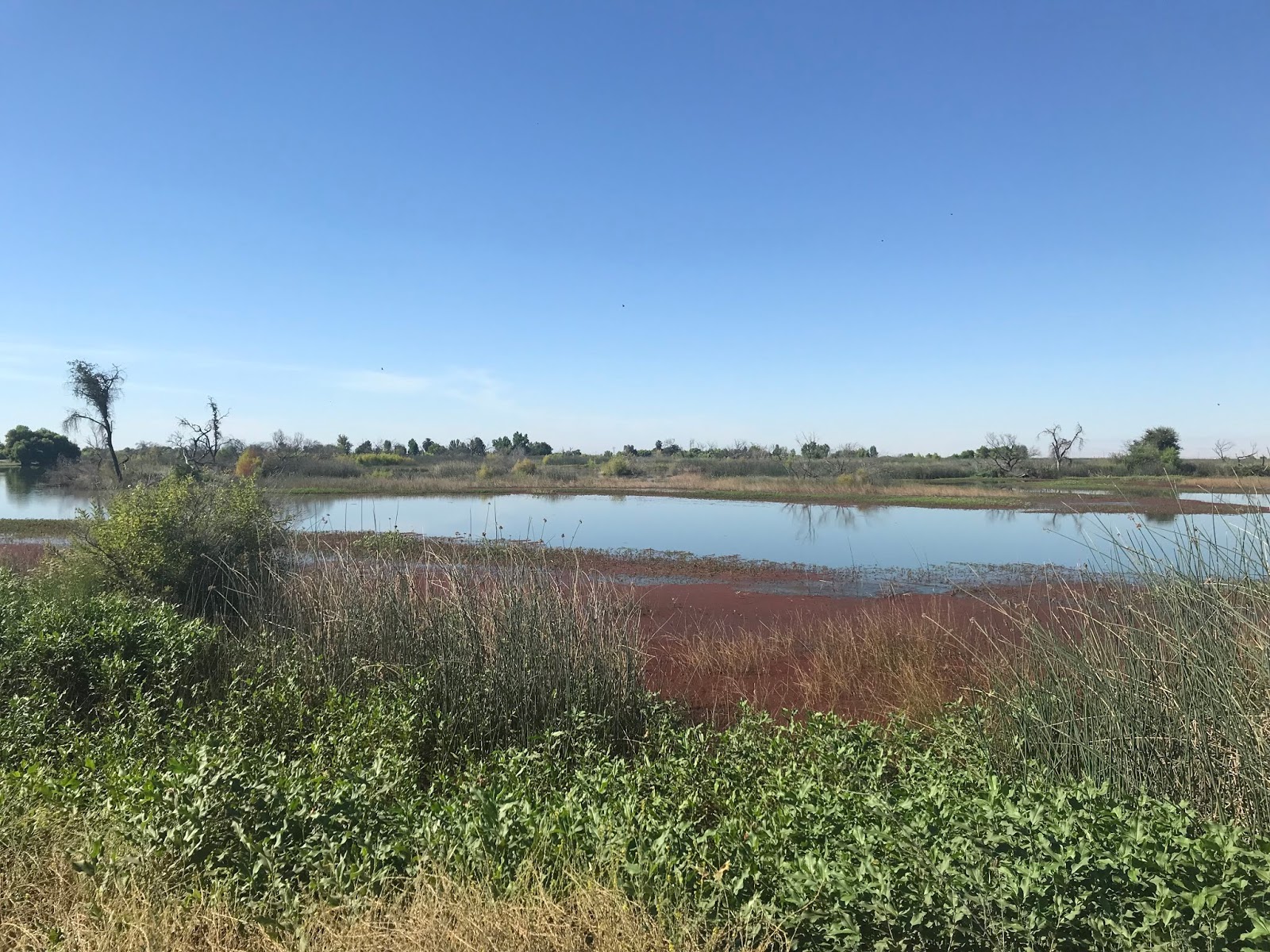
Part 2; Tulare Lake as it is now from 19th Avenue
Tulare Lake can be seen from 19th Avenue south of Stratford in a series of photos taken by Josh Schmid during the first weekend of May 2023. 19th Avenue between Manteca Avenue and Pueblo Avenue is presently closed across the Tulare Lake basin due to the rising waters.


Part 3; Roads, infrastructure and building associated with the Tulare Lake basin
At the southwest corner of California State Route 41 and Lacey Boulevard the location of Adobe de Los Robles Rancho can be found. This restored adobe was constructed during 1846 by Daniel Rhodes near the northern historic extent of Tulare Lake.


At the northern extent of the Tulare Lake basin the location of Chisholm Ferry can be found just south of Jackson Avenue (former California State Route 198) approximately four miles of Lemoore. Chisholm Ferry crossed the Kings River where the historic northern extent of the Tulare Lake once was. At some point during the 1880s Chisholm's Ferry was founded on the Kings River which can be seen southwest of Lemoore on the 1885 Lemoore & Hanford Area Irrigation Map.

At some point between 1885 and 1892 Chisholm's Ferry was replaced by a truss bridge. The Chisholm's Ferry Bridge can be seen on the far left on this snipped image from an 1892 Thompson Map of Tulare County.

The Chisholm's Ferry Bridge location can be seen by looking south from the Jackson Avenue Bridge over the Kings River. Chisholm's Ferry Bridge would be replaced by the bridges over Jackson Avenue after 1915 Legislative Chapter 404 would extend Legislative Route Number 10 from Hanford to San Lucas. Legislative Route Number 10 would later be assigned as California State Route 198 by August 1934.


From Avenal Cut-Off Road the eastbound approach to what was Chisholm's Ferry Bridge can be accessed on Murphy's Ranch Road. Murphy's Ranch Road doesn't directly access the Chisholm's Ferry Bridge location anymore as there is private property gated off at the Kings River.


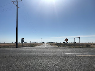
From Kettleman City north to Stratford much of modern California State Route 41 runs atop a levee in the Tulare Lake basin. Evidence of Tulare Lake can be found as California State Route 41 crosses the Kings River and on local farming businesses which reference "lake" in their name.


Along the historic eastern extent of the Tulare Lake basin the community of Allensworth can be found along California State Route 43 and Burlington Northern Santa Fe Railroad. Allensworth was founded in 1908 and is named after Colonial Allen Allensworth a freed slave who served in the Civil War. Allensworth was first plotted town in California that was built, governed, and completely populated by African Americans. The water supply of Allensworth became poisoned by arsenic in the ground water during the 1950s which led to the town declining. Allensworth became a State Historic Park in the 1970s.


Comments
NASA captures the difference between February 1st and April 30th via satellite imagery.