Within the counties north of San Francisco Bay there are numerous California State Routes that are little more than lines on paper. Some of these "Paper Highways" are unbuilt portions of active State Routes whereas other never were more than a line on a map or a piece of a State Legislation. These Paper Highways include; CA 12, CA 17, CA 37, CA 181, CA 251, and CA 281. Note; despite these highways existing in limbo on paper for over half a century none of them have been Legislatively cancelled.

Part 1; the logical original terminus of CA 12 and it's unbuilt reroute alignment
CA 12 was one of the original run of Sign State Routes announced in a August 1934 Department of Public Works Guide. CA 12 originally had a western terminus at CA 1 in Jenner of Sonoma County via Legislative Route 104 west of Santa Rosa.


CA 12 can be seen ending at Jenner and CA 1 via LRN 104 on the 1963 Division of Highways State Map.

During the 1964 State Highway Renumbering CA 12 was truncated to Sebastopol and CA 116 was aligned over it's former route west on what was LRN 104 to CA 1 in Jenner. CA 12 subsequently assumed the planned route of what was LRN 51 from Sebastopol west to CA 1 in Valley Ford. The unbuilt Sebastopol-Valley Ford segment of LRN 51 had been added to the route definition by the State Legislature in 1951 according to CAhighways. The change in routing of CA 12 west of Sebastopol can be seen on the 1964 Division of Highways State Map. CA 12 west of Sebastopol to Valley Ford never had a determined routing but Bodega Highway and Freestone-Valley Ford Road is a close analog. The rerouting of CA 12 onto an ultimately never constructed highway led to the odd circumstance where a three digit State Route superseded a two digit one.

Part 2; the unbuilt extension of CA 17 and unbuilt CA 251
During the 1964 State Highway Renumbering CA 17 had been Legislatively extended west of US 101 on what had been a segment of LRN 69. This segment of LRN 69 had been added as a route definition extension west of San Rafael to Point Reyes Station (both within Marin County) in 1959 according to CAhighways. LRN 69 west of San Rafael to Point Reyes Station appears to have been planned to follow the general course of Sir Francis Drake Boulevard. LRN 69 west of San Rafael to Point Reyes Station can be seen on the 1963 Division of Highways State Map.

LRN 69 west of San Rafael to Point Reyes Station can be seen assigned to CA 17 on the 1964 Division of Highways State Map. CA 17 west of San Rafael to Point Reyes Station never had a determined routing.

Likewise 1959 (according to CAhighways) also saw the creation of LRN 251 between CA 17 at Point San Quentin west to US 101 in Greenbrae. The short route of LRN 251 was retained it's number of CA 251 during the 1964 State Highway Renumbering. Much like the planned route of LRN 69/CA 17 the route of CA 251/LRN 251 appears to have been planned to follow the general corridor Sir Francis Drake Boulevard (albeit likely as a straightened freeway-to-freeway connector route) in San Quentin. CA 251 appears on the Bay Area detail insert of the 1964 Division of Highways State Map.

The desire for CA 251 in San Quentin can be observed from modern day I-580 westbound. I-580 westbound does not intersect US 101 southbound at it's terminus in San Rafael. US 101 southbound traffic is directed to follow Sir Francis Drake Boulevard through San Quentin from I-580 Exit 2A.


Part 3; unbuilt CA 37 west of US 101

During the 1964 State Highway Renumbering CA 37 was realigned directly east from Sears Point via what had been CA 48/LRN 8. CA 37 northeast of Sears Point on LRN 8 was renumbered to CA 121. Unbuilt LRN 252 was changed to legislatively to CA 37. All these changes can be seen on the 1964 Division of Highways State Map. CA 37 west of US 101 never had a determined routing but it has a close analog with Novato Boulevard and Point Reyes-Petaluma Road.


The implied route of CA 37 between Sir Francis Drake Boulevard east to Novato was previously covered on the Disaster Tourism Series of 2017.
Disaster Tourism Road Trip Part 7; The Black Hole of Lake Berryessa, CA 37, CA 121, CA 128, and unbuilt CA 179
Part 4; unbuilt CA 181
CA 181 was a 1964 State Highway Renumbering assignment to LRN 250 between what had been CA 12 on LRN 104 east to US 101 in Forestville in Sonoma County. LRN 250 was defined in 1959 according CAhighways and can be seen on the 1963 Division of Highways State Map.

CA 181 can be seen as a planned route for the first time on the 1964 Division of Highways State Map. CA 181 never had a determined planned routing but River Road acts as a somewhat accurate analog.

Part 5; the strangeness of CA 281
CA 281 is even stranger than CA 181 and CA 251 given it was partially built. CA 281 was defined as a loop of CA 29 in 1970 according to CAhighways near Konocti Bay (of Clear Lake) to the vicinity of Lake Port. Unlike all the other highways in this blog the route of CA 281 technically isn't within the San Francisco Bay Area but rather Lake County. CA 281 appears as a partially constructed highway near Konocti Bay on the 1975 Caltrans State Map.
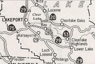
CA 281 for as little as it is known has 3 constructed miles which appear in the Caltrans Post Mile Tool as Post Mile LAK 14.0-17.0 on Soda Bay Road. Soda Bay Road northwest to CA 29 more or less is the implied connection of CA 281 beyond State Maintenance.

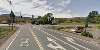
 Interestingly CA 281 appears to be fully signed from the junction with CA 29 at Post Mile 17.000 as seen on Google Street View.


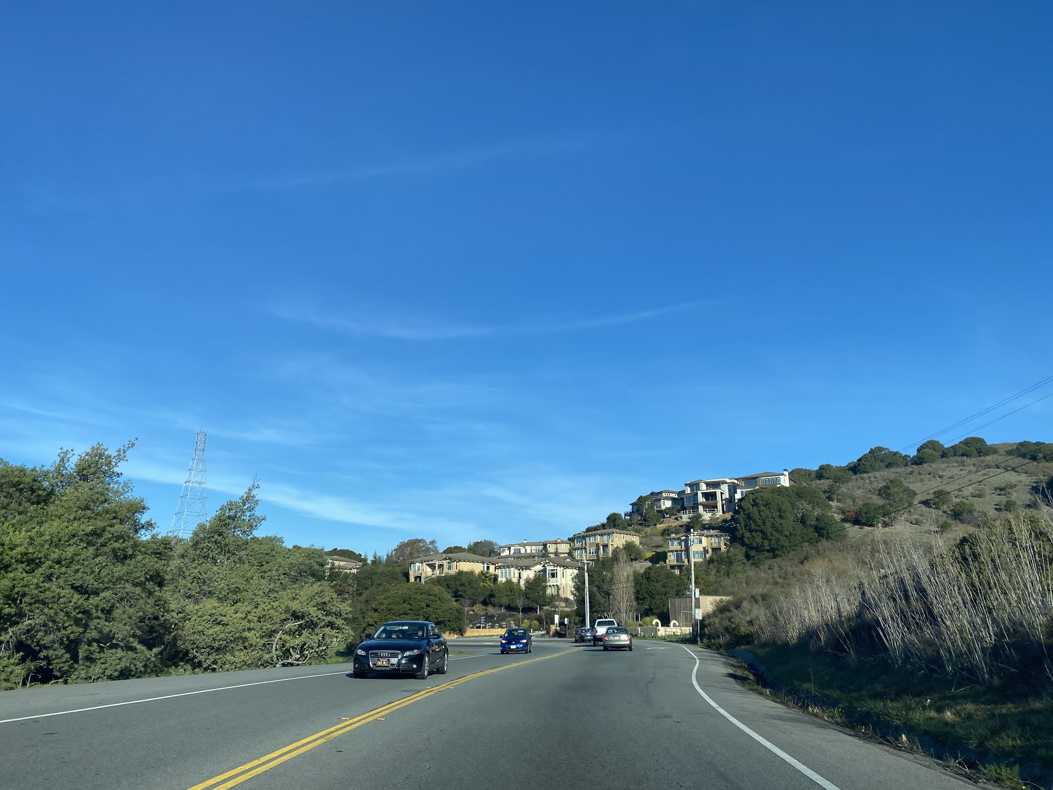
Further CA 281 has an "End" placard and shield at Post Mile LAK 14.000 as seen on Google Street View.

According to CAhighways Post Mile LAK 13.2-14.000 is planned but thus far nothing west of that point.

Part 1; the logical original terminus of CA 12 and it's unbuilt reroute alignment
CA 12 was one of the original run of Sign State Routes announced in a August 1934 Department of Public Works Guide. CA 12 originally had a western terminus at CA 1 in Jenner of Sonoma County via Legislative Route 104 west of Santa Rosa.

CA 12 can be seen ending at Jenner and CA 1 via LRN 104 on the 1963 Division of Highways State Map.

During the 1964 State Highway Renumbering CA 12 was truncated to Sebastopol and CA 116 was aligned over it's former route west on what was LRN 104 to CA 1 in Jenner. CA 12 subsequently assumed the planned route of what was LRN 51 from Sebastopol west to CA 1 in Valley Ford. The unbuilt Sebastopol-Valley Ford segment of LRN 51 had been added to the route definition by the State Legislature in 1951 according to CAhighways. The change in routing of CA 12 west of Sebastopol can be seen on the 1964 Division of Highways State Map. CA 12 west of Sebastopol to Valley Ford never had a determined routing but Bodega Highway and Freestone-Valley Ford Road is a close analog. The rerouting of CA 12 onto an ultimately never constructed highway led to the odd circumstance where a three digit State Route superseded a two digit one.

Part 2; the unbuilt extension of CA 17 and unbuilt CA 251
During the 1964 State Highway Renumbering CA 17 had been Legislatively extended west of US 101 on what had been a segment of LRN 69. This segment of LRN 69 had been added as a route definition extension west of San Rafael to Point Reyes Station (both within Marin County) in 1959 according to CAhighways. LRN 69 west of San Rafael to Point Reyes Station appears to have been planned to follow the general course of Sir Francis Drake Boulevard. LRN 69 west of San Rafael to Point Reyes Station can be seen on the 1963 Division of Highways State Map.

LRN 69 west of San Rafael to Point Reyes Station can be seen assigned to CA 17 on the 1964 Division of Highways State Map. CA 17 west of San Rafael to Point Reyes Station never had a determined routing.

Likewise 1959 (according to CAhighways) also saw the creation of LRN 251 between CA 17 at Point San Quentin west to US 101 in Greenbrae. The short route of LRN 251 was retained it's number of CA 251 during the 1964 State Highway Renumbering. Much like the planned route of LRN 69/CA 17 the route of CA 251/LRN 251 appears to have been planned to follow the general corridor Sir Francis Drake Boulevard (albeit likely as a straightened freeway-to-freeway connector route) in San Quentin. CA 251 appears on the Bay Area detail insert of the 1964 Division of Highways State Map.


In 1984 CA 17 north of I-280 to I-80/I-580 was reassigned as I-880 on the Nimitz Freeway. CA 17 north of I-80 to US 101 had been reassigned as an extension of I-580. The truncation of CA 17 to I-280 led to the planned route of the highway west of San Rafael to Point Reyes State being transferred to CA 251 according to CAhighways. CA 251 appears as a planned route from Point San Quentin west to Point Reyes Station on the 1986 Caltrans State Map. CA 251 in it's current form has never had a determined planned routing.

Part 3; unbuilt CA 37 west of US 101
In 1959 according the second Legislative Route 252
was defined as a new State Highway between US 101 west to planned CA
17. LRN 252 was intended to be part of CA 37 and first appears on the 1960 Division of Highways State Map.

During the 1964 State Highway Renumbering CA 37 was realigned directly east from Sears Point via what had been CA 48/LRN 8. CA 37 northeast of Sears Point on LRN 8 was renumbered to CA 121. Unbuilt LRN 252 was changed to legislatively to CA 37. All these changes can be seen on the 1964 Division of Highways State Map. CA 37 west of US 101 never had a determined routing but it has a close analog with Novato Boulevard and Point Reyes-Petaluma Road.


The implied route of CA 37 between Sir Francis Drake Boulevard east to Novato was previously covered on the Disaster Tourism Series of 2017.
Disaster Tourism Road Trip Part 7; The Black Hole of Lake Berryessa, CA 37, CA 121, CA 128, and unbuilt CA 179
Part 4; unbuilt CA 181
CA 181 was a 1964 State Highway Renumbering assignment to LRN 250 between what had been CA 12 on LRN 104 east to US 101 in Forestville in Sonoma County. LRN 250 was defined in 1959 according CAhighways and can be seen on the 1963 Division of Highways State Map.

CA 181 can be seen as a planned route for the first time on the 1964 Division of Highways State Map. CA 181 never had a determined planned routing but River Road acts as a somewhat accurate analog.

Part 5; the strangeness of CA 281
CA 281 is even stranger than CA 181 and CA 251 given it was partially built. CA 281 was defined as a loop of CA 29 in 1970 according to CAhighways near Konocti Bay (of Clear Lake) to the vicinity of Lake Port. Unlike all the other highways in this blog the route of CA 281 technically isn't within the San Francisco Bay Area but rather Lake County. CA 281 appears as a partially constructed highway near Konocti Bay on the 1975 Caltrans State Map.

CA 281 for as little as it is known has 3 constructed miles which appear in the Caltrans Post Mile Tool as Post Mile LAK 14.0-17.0 on Soda Bay Road. Soda Bay Road northwest to CA 29 more or less is the implied connection of CA 281 beyond State Maintenance.


Further CA 281 has an "End" placard and shield at Post Mile LAK 14.000 as seen on Google Street View.

According to CAhighways Post Mile LAK 13.2-14.000 is planned but thus far nothing west of that point.
Comments
I'm wondering why CA 181 didn't extend to SR 29 in Calistoga.
Thanks for all your cool posts. I've done a conceptual alignment for CA 37 from 101 to West Marin around Novato.