This past June I visited much of what was the original alignment of US Route 101 within the City of Salinas.

Part 1; the history of US Route 101 in Salinas
Salinas is presently the largest City in Monterey County and is the County Seat. Salinas lies within Salinas Valley and is located east of the namesake river. Originally El Camino Real originally was routed through Salinas Valley on a course towards the Monterey Peninsula. The route of El Camino Real was intended to solidify a path of travel between the Catholic Missions of Las Californias. In 1797 Mission San Juan Bautista was founded which led to a need for a spur of El Camino Real to be built from Salinas Valley over the Gabilan Range. This spur of El Camino Real would become what is now Old Stage Road. The split in the paths of El Camino Real roughly was located where the City of Salinas now sits.
In 1804 Alta California was formed out of the larger Las Californias but the junction of El Camino Real in Salinas Valley remained important. El Camino Real would ultimately connect 21 Catholic Missions of Alta California ranging approximately 600 miles spanning from Mission San Diego de Alcala in San Diego north to Mission San Francisco Solano in Sonoma. The Missions of El Camino Real were established from 1769 through 1823. In the case of Mission San Francisco Solano it was established two years after Mexico had won it's independence from Spain in 1821. Each Mission was meant to be approximately 30 miles apart from each other which would require a single day of travel by horseback. Following the advent of Mexican independence from Spain the usage of the term "El Camino Real" largely fell into disuse.
Alta California was annexed by the United States in early 1848 and became the State of California in 1850. What had been spurs of El Camino Real remained an important path of travel in Salinas Valley and was settled as Salinas Junction in 1854. The name "Salinas" seems to have come from the 1795 Spanish grant of Rancho Las Salinas. The Salinas River in turn seems to have taken it's name from the American Salinas Junction in 1858 after previously having been known as Rio de Monterey. The plot of the streets of Salinas was laid out in 1867 and the City incorporated in 1874.
Salinas along with it's route north over what is now Old Stage Road towards San Juan Bautista can be seen on the 1857 Britton & Rey's Road Map of California.

Likewise Salinas and the route north to San Juan Bautista via Old Stage Road appears on the 1873 California Geological Survey Map of Central California.

In 1904 the American El Camino Real Association was formed with the goal to mark a modern highway that corresponded to the historical route between the Spanish Missions. Ultimately the path of American El Camino Real was to be marked by the signature bells the corridor is known by today. The first bell marking the American El Camino Real was placed in 1906 and it is estimated by 1915 that there may have been anywhere to 158 to 400 placed in-field. The American El Camino Real was one of the earliest analogs of what would become the signed Auto Trails. The American El Camino Real just as it's Spanish predecessor crossed the Gabilan Range via Old Stage Road. The background of the American El Camino Real is covered extensively on CAhighways.org.
CAhighyways.org on the American El Camino Real
The era of State Highway Maintenance through Salinas and the Gablian Range would ultimately begin with the 1909 First State Highway Bond Act which was approved by voters in 1910. One of the highways approved through the 1909 First State Highway Bond Act was a 481.8 mile highway originating at the City Limits of San Francisco which terminated in San Diego. This highway would ultimately come to be known in time as Legislative Route Number 2.
Old Stage Road even by the conventions of the 1910s was woefully inadequate for usage by automobiles. The terrain of the Gabilan Range between San Juan Bautista and Salinas Valley was so rugged that an alternate route from Gilroy to Salinas by way of Watsonville and Castroville was considered. This 1913 highway proposal of LRN 2 shows what could have been an alternate highway routed west from San Juan Bautista.

Ultimately the San Juan Grade was completed by 1915 and replaced Old Stage Road as the primary highway from Salinas to San Juan Bautista. The initial route of LRN 2 and the American El Camino Real through Salinas was as follows headed northbound towards San Juan Bautista:
- Abbott Street to John Street.
- John Street to Main Street in downtown Salinas.
- Main Street through downtown Salinas to the San Juan Grade.
Ultimately LRN 2 and the San Juan Grade became part of US Route 101 in late 1926. US 101/LRN 2 was ultimately shifted west of the Saan Juan Grade onto what is known as the Prunedale Cut-Off in summer of 1932. This construction of the Prunedale Cut-Off bypass route of the San Juan Grade can be seen on the October 1931 edition of the California Highways and Public Works Journal and on CAhighways.org Legislative Route 2 page.


The Prunedale Cut-Off while straightening the alignment of US 101/LRN 2 north of Salinas had virtually had no impact on the alignment in the City. US 101/LRN 2 through Salinas and the Prunedale Cut-Off can be seen on the 1935 California Division of Highways Map of Monterey County.

These maps below represent the original alignment of US 101/LRN 2 through Salinas south of the San Juan Grade.


The early phase of the expressway upgrades of US 101/LRN 2 appear in the January/February 1952 California Highway and Public Works Guide. The construction of the expressway segment of US 101/LRN 2 (called the Salinas Freeway) within the City of Salinas is cited to have an anticipated start date of Spring 1952.


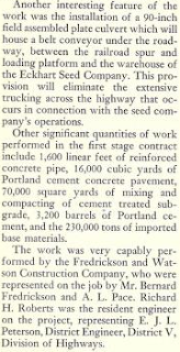
The July/August 1953 California Highways and Public Works Guide describes the first phase of the Salinas Freeway as nearly being complete between the Spence Underpass (near Hartnell Road) and Market Street. Traffic on US 101/LRN 2 would have been routed on a temporary alignment via Market Street to the existing highway on North Main Street north of downtown Salinas. Note; it was likely around this time that northbound State Highway traffic began to utilize Monterey Street from Market Street to reach North Main Street under the Union Pacific (at the time Southern Pacific) underpass. Conversely this would have transitioned southbound State Highway traffic at the Union Pacific underpass on North Main Street to Market Street. The Salinas Freeway bypass of Abbott Street, John Street, and South Main Street effectively extended Legislative Route 117 to US 101/LRN 2 via John Street. LRN 117 would begin to be signed as CA 68 starting in 1961.


The March/April 1954 California Highways and Public Works Guide presents an article detailing the expansion of US 101/LRN 2 on the Salinas Freeway to from Market Street to North Main Street. This new alignment of US 101/LRN 2 the Salinas Freeway effectively bypassed downtown. An expansion of the Salinas Freeway north to Espinosa Road is cited to be on hold due to a lack of funding. The completion of the Salinas Freeway to North Main Street effectively extended Legislative Route 118 to US 101/LRN 2 at the new interchange north of downtown Salinas. LRN 118 would become CA 183 during the 1964 State Highway Renumbering.


In the March/April 1961 California Highways and Public Works Guide the freeway routing of US 101/LRN 1 between North Main Street to Espinosa Drive is shown as having an adopted route in an article titled; "Salinas Valley, New US 101 Freeway Sections Bring Traffic Relief to Area.


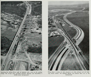


The November/December 1963 California Highways and Public Works Guide states that the freeway expansion of US 101/LRN 2 between North Main Street and Espinosa Road had been budgeted.


The November/December 1964 California Highways and Public Works Guide states that the expansion of US 101 onto a new freeway grade between North Main Street to Espinosa Street was scheduled to open in summer 1965. Note; the Legislative Routes were dropped during the 1964 State Highway Renumbering and were redefined with what they were signed as in-field. Thus, LRN 2 was dropped in favor of being legislatively designated as US 101.

The November/December 1965 California Highways and Public Works guide states that US 101 between North Main Street to Espinosa Road was moved to a new freeway grade in early November.

Part 2; tracing the original alignment of US 101 in Salinas
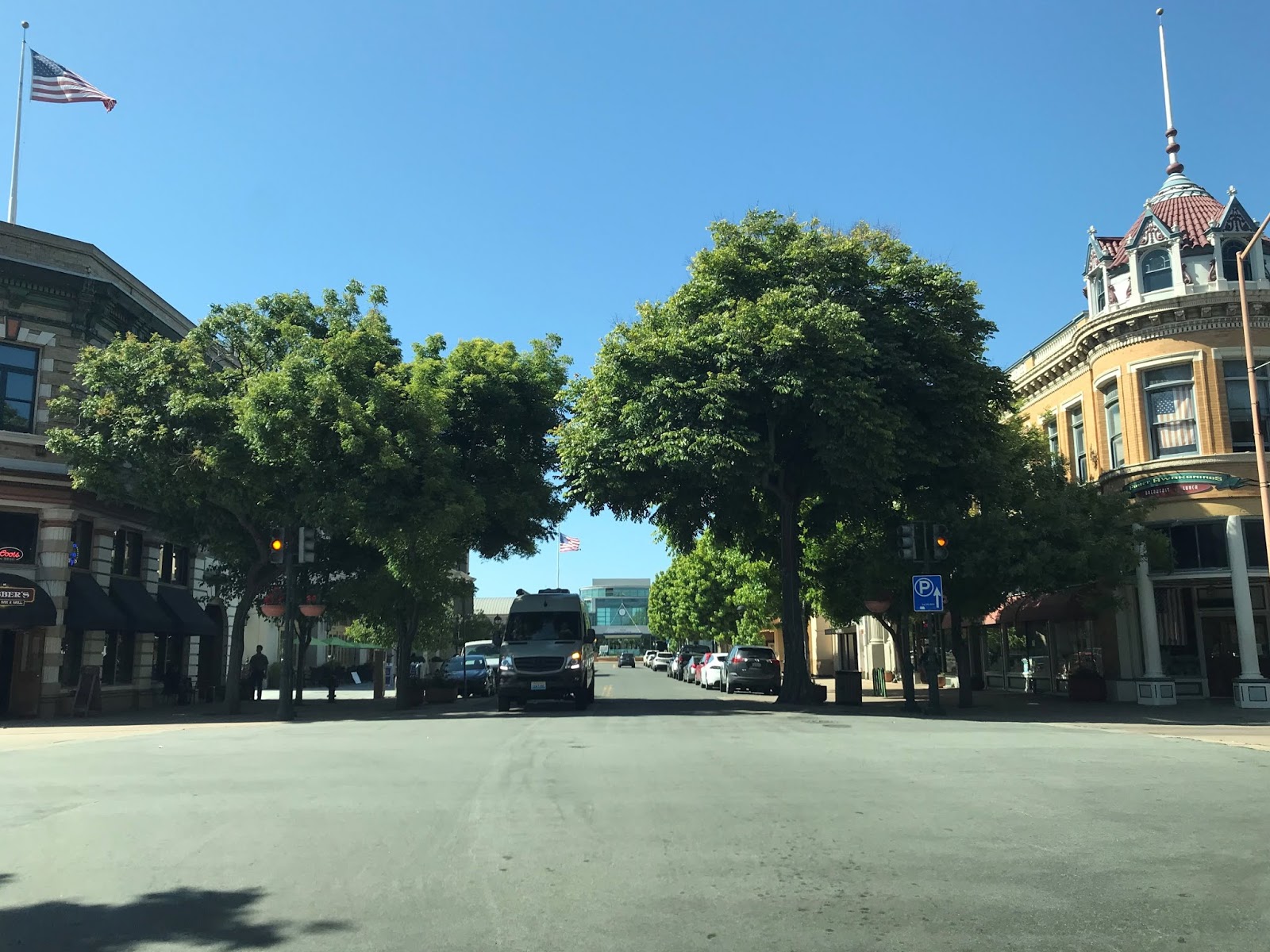
Back in 2017 while clinching CA 68 I drove former US 101 on John Street west of Abbott Street to South Main Street. Whereas as CA 68 westbound turns left onto South Main Street former US 101 northbound turned right towards downtown Salinas.

Former US 101 northbound on South Main Street was a definitely a bottleneck point which becomes very apparent north of San Luis Street. Those photos of South Main Street were taken in summer of 2019.


Presently former US 101 on South Main Street is configured as one-way northbound through downtown Salinas. South Main Street crosses Alisal Street and Gabilan Street before dead-ending at Central Avenue.


The Salinas City Center now sits where South Main Street once carried US 101 onto North Main Street.

These photos of CA 183 below were taken when I clinched the highway in 2017. In the first photo the back side of the Salinas City Center can be seen from southbound CA 183 on Market Street. Former US 101 northbound would have crossed here from South Main Street to North Main Street. Traffic today on northbound CA 183 now uses North Main Street southbound to Market Street whereas southbound CA 183 turns onto Monterey Street from Market Street (Photo 2) to reach North Market Street.


The transition of CA 183 southbound on Monterey Street to North Main Street can be seen below at the Union Pacific Railroad underpass. Former US 101 northbound would have simply used North Main Street on the left.

Present CA 183 southbound ends at US 101 at the Salinas Freeway grade via North Main Street. Former US 101 on North Main Street would have continued to the San Juan Grade near Santa Rita where the historic alignments would have split towards San Juan Bautista and Prunedale.


Part 1; the history of US Route 101 in Salinas
Salinas is presently the largest City in Monterey County and is the County Seat. Salinas lies within Salinas Valley and is located east of the namesake river. Originally El Camino Real originally was routed through Salinas Valley on a course towards the Monterey Peninsula. The route of El Camino Real was intended to solidify a path of travel between the Catholic Missions of Las Californias. In 1797 Mission San Juan Bautista was founded which led to a need for a spur of El Camino Real to be built from Salinas Valley over the Gabilan Range. This spur of El Camino Real would become what is now Old Stage Road. The split in the paths of El Camino Real roughly was located where the City of Salinas now sits.
In 1804 Alta California was formed out of the larger Las Californias but the junction of El Camino Real in Salinas Valley remained important. El Camino Real would ultimately connect 21 Catholic Missions of Alta California ranging approximately 600 miles spanning from Mission San Diego de Alcala in San Diego north to Mission San Francisco Solano in Sonoma. The Missions of El Camino Real were established from 1769 through 1823. In the case of Mission San Francisco Solano it was established two years after Mexico had won it's independence from Spain in 1821. Each Mission was meant to be approximately 30 miles apart from each other which would require a single day of travel by horseback. Following the advent of Mexican independence from Spain the usage of the term "El Camino Real" largely fell into disuse.
Alta California was annexed by the United States in early 1848 and became the State of California in 1850. What had been spurs of El Camino Real remained an important path of travel in Salinas Valley and was settled as Salinas Junction in 1854. The name "Salinas" seems to have come from the 1795 Spanish grant of Rancho Las Salinas. The Salinas River in turn seems to have taken it's name from the American Salinas Junction in 1858 after previously having been known as Rio de Monterey. The plot of the streets of Salinas was laid out in 1867 and the City incorporated in 1874.
Salinas along with it's route north over what is now Old Stage Road towards San Juan Bautista can be seen on the 1857 Britton & Rey's Road Map of California.

Likewise Salinas and the route north to San Juan Bautista via Old Stage Road appears on the 1873 California Geological Survey Map of Central California.

In 1904 the American El Camino Real Association was formed with the goal to mark a modern highway that corresponded to the historical route between the Spanish Missions. Ultimately the path of American El Camino Real was to be marked by the signature bells the corridor is known by today. The first bell marking the American El Camino Real was placed in 1906 and it is estimated by 1915 that there may have been anywhere to 158 to 400 placed in-field. The American El Camino Real was one of the earliest analogs of what would become the signed Auto Trails. The American El Camino Real just as it's Spanish predecessor crossed the Gabilan Range via Old Stage Road. The background of the American El Camino Real is covered extensively on CAhighways.org.
CAhighyways.org on the American El Camino Real
The era of State Highway Maintenance through Salinas and the Gablian Range would ultimately begin with the 1909 First State Highway Bond Act which was approved by voters in 1910. One of the highways approved through the 1909 First State Highway Bond Act was a 481.8 mile highway originating at the City Limits of San Francisco which terminated in San Diego. This highway would ultimately come to be known in time as Legislative Route Number 2.
Old Stage Road even by the conventions of the 1910s was woefully inadequate for usage by automobiles. The terrain of the Gabilan Range between San Juan Bautista and Salinas Valley was so rugged that an alternate route from Gilroy to Salinas by way of Watsonville and Castroville was considered. This 1913 highway proposal of LRN 2 shows what could have been an alternate highway routed west from San Juan Bautista.

Ultimately the San Juan Grade was completed by 1915 and replaced Old Stage Road as the primary highway from Salinas to San Juan Bautista. The initial route of LRN 2 and the American El Camino Real through Salinas was as follows headed northbound towards San Juan Bautista:
- Abbott Street to John Street.
- John Street to Main Street in downtown Salinas.
- Main Street through downtown Salinas to the San Juan Grade.
Ultimately LRN 2 and the San Juan Grade became part of US Route 101 in late 1926. US 101/LRN 2 was ultimately shifted west of the Saan Juan Grade onto what is known as the Prunedale Cut-Off in summer of 1932. This construction of the Prunedale Cut-Off bypass route of the San Juan Grade can be seen on the October 1931 edition of the California Highways and Public Works Journal and on CAhighways.org Legislative Route 2 page.


The Prunedale Cut-Off while straightening the alignment of US 101/LRN 2 north of Salinas had virtually had no impact on the alignment in the City. US 101/LRN 2 through Salinas and the Prunedale Cut-Off can be seen on the 1935 California Division of Highways Map of Monterey County.

These maps below represent the original alignment of US 101/LRN 2 through Salinas south of the San Juan Grade.


The early phase of the expressway upgrades of US 101/LRN 2 appear in the January/February 1952 California Highway and Public Works Guide. The construction of the expressway segment of US 101/LRN 2 (called the Salinas Freeway) within the City of Salinas is cited to have an anticipated start date of Spring 1952.


The July/August 1953 California Highways and Public Works Guide describes the first phase of the Salinas Freeway as nearly being complete between the Spence Underpass (near Hartnell Road) and Market Street. Traffic on US 101/LRN 2 would have been routed on a temporary alignment via Market Street to the existing highway on North Main Street north of downtown Salinas. Note; it was likely around this time that northbound State Highway traffic began to utilize Monterey Street from Market Street to reach North Main Street under the Union Pacific (at the time Southern Pacific) underpass. Conversely this would have transitioned southbound State Highway traffic at the Union Pacific underpass on North Main Street to Market Street. The Salinas Freeway bypass of Abbott Street, John Street, and South Main Street effectively extended Legislative Route 117 to US 101/LRN 2 via John Street. LRN 117 would begin to be signed as CA 68 starting in 1961.


The March/April 1954 California Highways and Public Works Guide presents an article detailing the expansion of US 101/LRN 2 on the Salinas Freeway to from Market Street to North Main Street. This new alignment of US 101/LRN 2 the Salinas Freeway effectively bypassed downtown. An expansion of the Salinas Freeway north to Espinosa Road is cited to be on hold due to a lack of funding. The completion of the Salinas Freeway to North Main Street effectively extended Legislative Route 118 to US 101/LRN 2 at the new interchange north of downtown Salinas. LRN 118 would become CA 183 during the 1964 State Highway Renumbering.


In the March/April 1961 California Highways and Public Works Guide the freeway routing of US 101/LRN 1 between North Main Street to Espinosa Drive is shown as having an adopted route in an article titled; "Salinas Valley, New US 101 Freeway Sections Bring Traffic Relief to Area.


The November/December 1963 California Highways and Public Works Guide states that the freeway expansion of US 101/LRN 2 between North Main Street and Espinosa Road had been budgeted.
The November/December 1964 California Highways and Public Works Guide states that the expansion of US 101 onto a new freeway grade between North Main Street to Espinosa Street was scheduled to open in summer 1965. Note; the Legislative Routes were dropped during the 1964 State Highway Renumbering and were redefined with what they were signed as in-field. Thus, LRN 2 was dropped in favor of being legislatively designated as US 101.
The November/December 1965 California Highways and Public Works guide states that US 101 between North Main Street to Espinosa Road was moved to a new freeway grade in early November.
Part 2; tracing the original alignment of US 101 in Salinas
Back in 2017 while clinching CA 68 I drove former US 101 on John Street west of Abbott Street to South Main Street. Whereas as CA 68 westbound turns left onto South Main Street former US 101 northbound turned right towards downtown Salinas.

Former US 101 northbound on South Main Street was a definitely a bottleneck point which becomes very apparent north of San Luis Street. Those photos of South Main Street were taken in summer of 2019.


Presently former US 101 on South Main Street is configured as one-way northbound through downtown Salinas. South Main Street crosses Alisal Street and Gabilan Street before dead-ending at Central Avenue.


The Salinas City Center now sits where South Main Street once carried US 101 onto North Main Street.

These photos of CA 183 below were taken when I clinched the highway in 2017. In the first photo the back side of the Salinas City Center can be seen from southbound CA 183 on Market Street. Former US 101 northbound would have crossed here from South Main Street to North Main Street. Traffic today on northbound CA 183 now uses North Main Street southbound to Market Street whereas southbound CA 183 turns onto Monterey Street from Market Street (Photo 2) to reach North Market Street.


The transition of CA 183 southbound on Monterey Street to North Main Street can be seen below at the Union Pacific Railroad underpass. Former US 101 northbound would have simply used North Main Street on the left.

Present CA 183 southbound ends at US 101 at the Salinas Freeway grade via North Main Street. Former US 101 on North Main Street would have continued to the San Juan Grade near Santa Rita where the historic alignments would have split towards San Juan Bautista and Prunedale.


Comments