
California State Route 24 is a 13.5 mile freeway aligned between Interstate 680 at Walnut Creek of Contra Costa County west to Interstate 980/Interstate 580 in Oakland in Alameda County. CA 24 is one of the original 1934 Signed State highways but also has been the most truncated from it's fullest scale. California State Route 24 has a unbuilt segment east of Interstate 680 towards California State Route 4 near Antioch.

California State Route 24 ("CA 24") reached it's maximum extent in 1935 when it was extended to the San Francisco Bay Area. In full scope CA 24 began at US Route 40 ("US 40") in Berkeley and crossed the Sierra Nevada Mountains to what is now US 395 near the Nevada State Line. What was one of the grandest State Highways in California is now primarily a commuter route for traffic heading into the Bay Area through the Diablo Range. CA 24 during it's prime can be observed on the 1937 Gousha Highway Map of California.


Given this blog is part of the 2017 November Bay Area Trip series (Part 3 specifically) the focus below will be on the current existing corridor of CA 24. CA 24 frequently has come up numerous times over the years in the Gribblenation blog series and the applicable links can be found below:
California State Route 13
- This blog covers the Warren Freeway but goes into
detail regarding former CA 24 on Ashby Avenue and Tunnel Road.
California State Route 242
- This blog covers what was CA 24 east of Walnut Creek through
Concord. Oddly CA 242 was signed as part of CA 24 at least until 1988
according to my map research. As noted above a wide bypass of Concord which CA 24 was
to be built upon was planned but never constructed.
Disaster Tourism Road Trip Part 8; CA 160 and CR J11 in the Sacramento River Delta
California State Route 160; the legacy of US Route 40/50/99/99E/99W, Lincoln Highway, Victory Highway, and CA 24
- These two blogs cover much of what was CA 24 in the Sacramento River Delta on current CA 160.
Highways in and around Old Sacramento; US 40, US 99W, CA 16, CA 24, CA 70, CA 99, CA 275 and more
- This blog covers the history of surface highways in Sacramento which
includes CA 24. CA 24 went through massive realignments in Sacramento
before the 1964 State Highway renumbering.
CA 113; a little big of vintage US 40, US 40A, US 99W and CA 24
- This blog covers the route of CA 113 which assumed portions of what were CA 24 between Woodland and Tudor.
California State Route 70; the Feather River Highway
- CA 70 is the largest segment of CA 24 to be split off and was even
part of US 40A at one point. In my personal opinion CA 70 as a
standalone highway is one of the greatest transportation marvels in the
State Highway system.
Part 1; the history of California State Route 24 in the San Francisco Bay Area
The genesis point for CA 24 being extended into the San Francisco Bay Area begins a couple years before the Sign State Routes were announced when Legislative Route Number 75 ("LRN 75") was added by 1931 Legislative Chapter 82. According to cahighways.org the original definition of LRN 75 was as simply "Walnut Creek to Oakland." The instigator for the adoption of LRN 75 was construct a replacement route for the Kennedy Tunnel and Tunnel Road.
The Kennedy Tunnel opened to traffic in 1903 and drastically cut the travel time between Oakland-Lafayette but going directly through the Berkeley Hills. The Kennedy Tunnel was timber lined, narrow and not really in any way designed with the automobile in mind. Despite being lit by 1914 the Kennedy Tunnel quickly became obsolete and a massive choke point for increasing automotive traffic. The increasing volume of traffic using the Kennedy Tunnel was used for justification for inclusion into the State Highway System. The ruins of the west portal of the Kennedy Tunnel at the intersection of Old Tunnel Road and Skyline Boulevard can be seen below.


Thusly LRN 75 first appears on the 1932 Division of Highways Map between Walnut Creek-Oakland.
LRN 75 was extended in 1933 and given the following route defintion:
- Oakland to LRN 5 near Stockton via Walnut Creek and Antioch
- LRN 4 near Stockton via Copperopolis to LRN 65 near Altaville
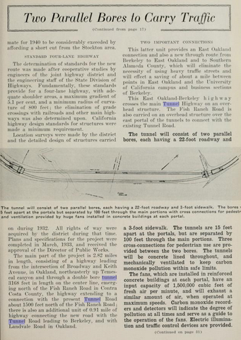
The May 1934 California Highways & Public Works details the design of two bores of the upcoming "Broadway Low Level Tunnel Project." The article goes onto detail a 1926 report spearheaded by Alameda County, Contra Costa County and City of Oakland which showed a need to replace the Kennedy Tunnel. The article goes further in providing detailed drawings of the bores of the Broadway Low Level Tunnels and comparing the planned new alignment of LRN 75 to existing Tunnel Road. Notably; Broadway towards Oakland and Ashby Avenue to Berkeley are cited as major connecting roads to the Broadway Low Level Tunnel Project.


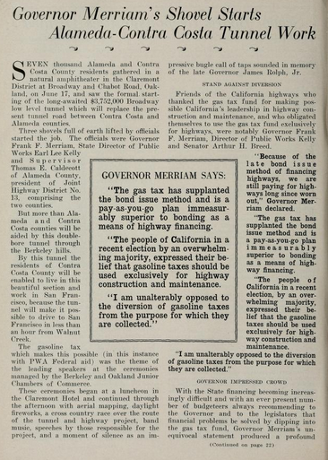
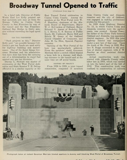
The July 1934 California Highways & Public Works details the ground breaking ceremony for the "Alameda-Contra Costa Tunnel" which took place on June 17th. The ground breaking ceremony was attended by notable figures such as; Governor Frank Merriam and State Director of Public Works Earl Lee Kelly.


The August 1934 California Highways & Public Works announced the initial run of Sign State Routes. CA 24 is noted as beginning at US 99 in Woodland and having a terminus at CA 7 near Reno Junction.


The future extension of CA 24 would see some activity upon the adoption of LRN 206 as part of 1935 Legislative Chapter 630. The initial definition of LRN 206 was from US 40/LRN 69 via Ashby Avenue to LRN 75. Subsequently the extension of CA 24 from the Sacramento Area to San Francisco Bay Area is announced in the October 1935 California Highways & Public Works. Of note; the article cites the new terminus of CA 24 as Oakland instead of Berkeley.

Some detail as to why LRN 75/Broadway versus LRN 206/Ashby Avenue was chosen as the initial extended terminus of CA 24 is provided on the 1935 California Division of Highways of Alameda County. Broadway is shown connecting directly with Tunnel Road whereas Ashby Avenue is not yet shown connecting to it.

For visual clarity CA 24/LRN 75 east of the Kennedy Tunnel towards Walnut Creek can be seen on the 1935 Division of Highways Map of Contra Costa County.

Ashby Avenue/LRN 206 is shown terminating at LRN 75/Tunnel Road on the 1936 Division of Highways State Map Insert.

This 1936 Shell Highway Map of Oakland shows CA 24/LRN 75 aligned through the Kennedy Tunnel. West of the Kennedy Tunnel CA 24/LRN 75 is shown following; Tunnel Road, Claremont Avenue, College Avenue and Broadway to a terminus at US 40/San Pablo Avenue.


The 1938 Division of Highways State Map City Insert shows CA 24 emerging from the Broadway Tunnel via LRN 75 and terminating in Berkeley via Ashby Avenue/LRN 206. It is unclear why the terminus of CA 24 was shifted from Oakland to Berkeley but it may have been done to better align it with the approach to the recently completed Bay Bridge.

In 1960 the Broadway Tunnel was renamed to the "Caldecott Tunnel" to honor Thomas E. Caldecott. During the 1964 State Highway Renumbering CA 24 was realigned from Ashby Avenue (which became part of CA 13) to a new western terminus at CA 17 in Oakland via Broadway. CA 24 saw it's eastern terminus truncated to CA 4 near Pittsburg. Notably; CA 24 between Interstate 580 (I-580) and CA 17 is shown as an unconstructed segment along with CA 24 east Walnut Creek towards the vicinity of Pittsburg/Antioch. CA 24 between I-680 and CA 4 is shown with a legislative designation of Route 242. These changes can be observed for the first time on the 1964 Division of Highways Map.


In reference to the unbuilt segment of CA 24 between Walnut Creek to Pittburg/Antioch it was adopted into the State Highway System as part of LRN 256 by way of 1959 Legislative Chapter 1062. LRN 256 can be seen on the 1963 Division of Highways State Map.

Conversely the segment of CA 24 from I-580 to CA 17 was adopted as part of LRN 226 during 1947 Legislative Chapter 11. The route of LRN 226 would involve the Posey Tubes and would eventually become partially current CA 260. The initial projected route of LRN 226 can be seen on the 1948 Division of Highways State Map City Insert.

The renovation of the first two bores of the Caldecott Tunnel and completion of the third bore are discussed in the May/June 1965 California Highways & Public Works. The third Caldecott Tunnel is cited as being completed and opened during October 1964 for use as westbound CA 24. The renovations of the first Caldecott Tunnel bores included the ability to change the direction of traffic flow in the central bore depending on when four lane volume was needed. The article stubs also notes advancements towards building CA 24 to full freeway capacity west of the Caldecott Tunnel.


The July/August 1966 California Highways & Public Works features the traffic reversal operations of the Caldecott Tunnel.


The November/December 1966 California Highways & Public Works cites the Grove-Shafter Freeway segment of CA 24 as being completed from the Caldecott Tunnel 0.4 miles west of CA 13. The stub article goes into detail about the planned extension of the Grove-Shafter Freeway westward to I-580.


CA 24 subsequently appears on the 1970 Division of Highways State Map City Insert as a freeway west of CA 13 into downtown Oakland but with no connection to CA 17.

CA 24 between I-580 and CA 17 was approved as non-chargeable Interstate 980 during July of 1976. This segment of CA 24 was legislatively reassigned as Route 980 during 1981 Legislative Chapter 292. The incomplete I-980 and truncated CA 24 appear on the 1982 Caltrans State Map.

As noted above CA 242 first appears with field signage replacing CA 24 between I-680-CA 4 near Concord on the 1988 Caltrans State Map.

Construction of the fourth Caldecott Tunnel bore began in 2010 and was opened to traffic on November 16th, 2013. The opening of the fourth Caldecott Tunnel bore removed the need for the reversible traffic in the central bore. The original two Caldecott Tunnel bores were oriented for eastbound traffic whereas the newest two bores were converted to westbound traffic. Photos below courtesy San Francisco Gate.


Part 2; a drive on California State Route 24
From I-680 northbound CA 24 westbound begins in Walnut Creek at Exit 46A.

CA 24 westbound enters Lafayette. Exit 14 accesses Pleasant Hill Road whereas Exit 11 accesses Central Lafayette. Note; the Exit numbers on CA 24 include the mileage from I-980.


CA 24 westbound next enters Orinda. Exit 10 accesses St. Stephens Drive whereas the Central Orinda Exit does not have a number.

Approaching the Caldecott Tunnel CA 24 westbound accesses Wilder Drive via Exit 7B whereas Exit 7A accesses Fish Ranch Road. Pictured below is the number 4 bore of the Caldecott Tunnel which is 3,389 feet in length. Caldecott Tunnel bores 1 & 2 are both 3,610 feet in length whereas bore 3 is 3,771 feet in length.
Upon passing through the Caldecott Tunnel CA 24 emerges into Oakland in Alameda County on the Grove Shafter Freeway. CA 24 Exit 6 accesses Tunnel Road whereas Exit 5A-B accesses CA 13.

CA 24 westbound Exit 4 accesses Broadway whereas the Telegraph Avenue Exit does not have a number. CA 24 terminates at the I-580/I-980 interchange in Oakland whereas the Grove-Shafter Freeway continues on I-980 to I-880.


Version History
- Published on 11/11/17
- Updated 1/28/21
Comments