California State Route 82/Old US Route 101 on the El Camino Real from San Francisco to Interstate 380
After completing Interstate 380 I made my way northward into the City Limits of San Francisco to drive the northernmost portion of California State Route 82.

CA 82 is 52 mile State Route between I-280 in San Francisco southward to Interstate 880 in San Jose. CA 82 is significant due to it being part of the historical surface alignment of US Route 101 and the El Camino Real.
The "El Camino Real" was a Spanish Highway in Las Californias and Alta California which connected the 21 Catholic Missions along the coast. Essentially the route of the El Camino Real was plotted out in the late 1700s from two Spanish survey expeditions. The Missions were plotted approximately 30 miles apart along the 600 mile route so that they would be a single day journey by horse. The El Camino Real name fell into disuse after the Mexican Revolution of 1821 but was revived by American highway promoters in the 1890s and 1900s. Today the El Camino Real is mostly associated with US 101 which follows the general path but deviates substantially from the actual trails that the Spanish used. CA 82 is one of the exceptions where a highway follows the route of the El Camino Real.
State Highway maintenance along the El Camino Real between San Francisco and San Jose began during the 1909 First State Highway Bond Act which was approved by voters in 1910. The route of the El Camino Real would be incorporated into what eventually became known as Legislative Route Number 2 by the 1915 Second State Highway Bond Act. LRN 2 as a highway was routed between the southern City limits of San Francisco southward to San Diego.
In 1926 the US Route system was created and US 101 was assigned to LRN 2 south of San Francisco and LRN 1 north of it. Within the City of San Francisco the route of US 101 was originally maintained at a local level rather than the California Division of Highways. The alignment history of early US 101 in San Francisco is complicated but I described in a previous blog about the Hyde Street Pier.
Begin quotation from the following blog post:
November Bay Trip Part 6; Downtown San Francisco and the Hyde Street Pier
"Understanding the alignments of US Routes in San Francisco is an odd one. Before 1933 the California Divisions of Highways apparently didn't even maintain any highways in the city limits of San Francisco. Trying to track down old maps of the city showing a clear alignment of US 101 prior the completion of Golden Gate Bridge is difficult given it was on city maintained streets. Back in the 1930s it wasn't uncommon even for state routes to be signed on non-state maintained roadway, the practice seems to have stopped by the end of the 1930s. The 1938 State Highway Map shows certain routes like CA 180, 33, and 49 partially on county or locally maintained roadways. Those roadways not maintained by the state are not shown as state highways by 1940.
1938 State Highway Map
1940 State Highway Map
So with that all in mind I've never seen a conclusive document showing a clear alignment of any US Route in San Francisco prior to 1937. That being the case I'll try to decipher the history of US Routes prior to the Bay Area Bridges being completed. Starting with US 101 I suspect that traffic heading south off of the Hyde Street Pier continued on Hyde and took a westward turn on Bay Street to Van Ness Avenue. The 1933 Goshua City Map Insert (courtsey of a link provided by USends.com) and the 1934 State Highway Map City insert show a major but yet unsigned route along those roads to the Hyde Street Pier.
1933 Bay Area City Insert
1934 State Highway Map City Insert
Of course that really doesn't explain the whole alignment history of when US 101 was split into US 101W and US 101E. Prior to 1929 US 101 was a stand alone route on the San Francisco side of the Bay before it split into dual routes. The original US 101 became US 101W while a new route from the ferries in Oakland was carved out of part of US 48 to become US 101E. USends has a map on the page about endpoints in San Francisco showing the split in US 101.
USends on San Francisco US Route end points
It would seem by at least 1936 US 101W was reconsolidated into mainline US 101 on the San Francisco side of the Bay while US 101E was partially absorbed by US 50 which was extended west from Hayward. US 40 and 50 were was officially routed into San Francisco in 1936 via the newly completed Bay Bridge as well.
1936 State Highway Map
1936 State Highway Map City Insert
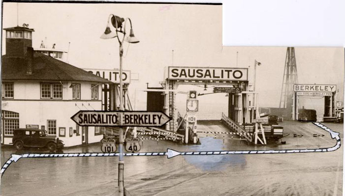
Regarding US 40 it seems that it was co-signed at the Hyde Street Pier along US 101. This photo of the Hyde Street Pier shows traffic being directed to board to the ferry for Berkeley.
Early Hyde Pier Photo
As I mentioned previously the roadways in San Francisco were city all city maintained until likely 1933 when the Golden Gate Bridge and Bay Bridge construction projects began. By 1935 there are clearly state maintained roadways shown on the California Divisions of Highway Map of San Francisco prior to the completion of the bridges.
1935 California Division of Highways City of San Francisco Map"
End quotation from the Hyde Street Pier blog.
In more simplistic terms of the original route of US 101 in San Francisco used the following route to the southern City Limit from Van Ness Aveune:
- Market Street to Valencia Street.
- Valencia Street to Mission Street.
- Mission Street to the City limits of San Francisco
Said route of US 101 upon through San Francisco is heavily implied by the 1930 State Highway Map City insert.
1930 State Highway Map City Insert
At least by 1934 US 101W was moved to the following alignment south of Van Ness Avenue after the California Division of Highways became involved with maintenance:
- Fell Street to 10th Street.
- 10th Street to Potrero Avenue.
- Potrero Avenue to Bayshore Boulevard
- Bayshore Boulevard to Alemany Boulevard
- Alemany Boulevard to San Jose Avenue
- San Jose Avenue out of the City of San Francisco to Mission Street
Said alignment above is clear on the 1935 Division of Highways Map of San Francisco the 1934 State Highway Map City Insert and as US 101 on the 1936 State Highway Map City Insert.
1934 State Highway Map City Insert
1935 San Francisco Highway Map
1936 State Highway Map City Insert
By 1937 US 101 was moved to the new route of the Bay Shore Freeway while the former surface route became US 101A. The split from US 101 and US 101A was at Bayshore Boulevard and Alemany Boulevard. US 101 followed LRN 68 on Bayshore Boulevard while US 101A followed Alemany Boulevard out of the City of San Francisco. This change can be seen on the 1938 State Highway Map City Insert.
1938 State Highway Map City Insert
By 1939 the mainline of US 101 was shifted back to it's surface alignment after local opposition and the new Bayshore Freeway route on LRN 68 was assigned as US 101 Bypass. This change can be seen on the 1940 State Highway Map City Insert.
1940 State Highway Map City Insert
During the 1964 State Highway renumbering the US 101 surface route on LRN 2 was reassigned as CA 82 while the US 101 Bypass Bayshore alignment on LRN 68 was given the US 101 mainline. This change can be seen by comparing the 1963 and 1964 State Highway Map City Inserts. Of note the 1964 City Insert shows the planned route of CA 82 ending at the planned route of CA 87 at San Francisco Bay.
1963 State Highway Map City Insert
1964 State Highway Map City Insert
At some point between 1967 and 1969 the north terminus of CA 82 was cut back to it's present location in San Francisco at I-280 on San Jose Avenue. Said change is reflected on the 1969 State Highway Map City Insert.
1969 State Highway Map City Insert
Much of the southern end of CA 82 was relinquished in San Jose by 2013. More details can be found at CAhighways.org.
CAhighways.org on CA 82
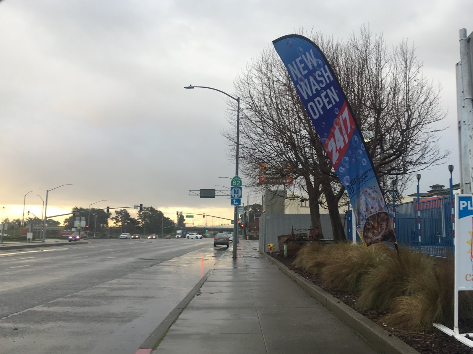
There is access to CA 82 south from I-280 northbound. I used John Daly Boulevard to reach CA 82 on Mission Street in Daly City. Mission Street continues right in the below photo whereas CA 82 on San Jose Avenue continues directly ahead towards I-280.

Upon heading northbound I entered San Francisco and headed to the north terminus of CA 82 on San Jose Avenue at I-280.

At I-280 I pulled a U-Turn and headed south on San Jose Avenue back towards Mission Street. CA 82 south quickly exits San Francisco and enters Daly City in San Mateo County.


CA 82 is remarkably well signed for an urban surface highway with various shields still in place. CA 82 south traverses through Daly City and Colma on Mission Street where the roadway becomes El Camino Real near the border of South San Francisco at Old Mission Road.


According to Chris Sampang much of Old Mission Road is the original alignment of US 101 and the El Camino Real which was bypassed in the 1930s. The original alignment of Old Mission Road bent back towards CA 82 over Colma Creek at one point.
The route of CA 82 south traverses through South San Francisco before entering San Bruno where it meets I-380. At I-380 I jumped on the freeway headed towards Devil's Slide. In total I traveled only about 7 miles of CA 82 between I-280 and I-380. Suffice to say there is much more to explore on the original alignment of US 101 all the way south to San Jose.


CA 82 is 52 mile State Route between I-280 in San Francisco southward to Interstate 880 in San Jose. CA 82 is significant due to it being part of the historical surface alignment of US Route 101 and the El Camino Real.
The "El Camino Real" was a Spanish Highway in Las Californias and Alta California which connected the 21 Catholic Missions along the coast. Essentially the route of the El Camino Real was plotted out in the late 1700s from two Spanish survey expeditions. The Missions were plotted approximately 30 miles apart along the 600 mile route so that they would be a single day journey by horse. The El Camino Real name fell into disuse after the Mexican Revolution of 1821 but was revived by American highway promoters in the 1890s and 1900s. Today the El Camino Real is mostly associated with US 101 which follows the general path but deviates substantially from the actual trails that the Spanish used. CA 82 is one of the exceptions where a highway follows the route of the El Camino Real.
State Highway maintenance along the El Camino Real between San Francisco and San Jose began during the 1909 First State Highway Bond Act which was approved by voters in 1910. The route of the El Camino Real would be incorporated into what eventually became known as Legislative Route Number 2 by the 1915 Second State Highway Bond Act. LRN 2 as a highway was routed between the southern City limits of San Francisco southward to San Diego.
In 1926 the US Route system was created and US 101 was assigned to LRN 2 south of San Francisco and LRN 1 north of it. Within the City of San Francisco the route of US 101 was originally maintained at a local level rather than the California Division of Highways. The alignment history of early US 101 in San Francisco is complicated but I described in a previous blog about the Hyde Street Pier.
Begin quotation from the following blog post:
November Bay Trip Part 6; Downtown San Francisco and the Hyde Street Pier
"Understanding the alignments of US Routes in San Francisco is an odd one. Before 1933 the California Divisions of Highways apparently didn't even maintain any highways in the city limits of San Francisco. Trying to track down old maps of the city showing a clear alignment of US 101 prior the completion of Golden Gate Bridge is difficult given it was on city maintained streets. Back in the 1930s it wasn't uncommon even for state routes to be signed on non-state maintained roadway, the practice seems to have stopped by the end of the 1930s. The 1938 State Highway Map shows certain routes like CA 180, 33, and 49 partially on county or locally maintained roadways. Those roadways not maintained by the state are not shown as state highways by 1940.
1938 State Highway Map
1940 State Highway Map
So with that all in mind I've never seen a conclusive document showing a clear alignment of any US Route in San Francisco prior to 1937. That being the case I'll try to decipher the history of US Routes prior to the Bay Area Bridges being completed. Starting with US 101 I suspect that traffic heading south off of the Hyde Street Pier continued on Hyde and took a westward turn on Bay Street to Van Ness Avenue. The 1933 Goshua City Map Insert (courtsey of a link provided by USends.com) and the 1934 State Highway Map City insert show a major but yet unsigned route along those roads to the Hyde Street Pier.
1933 Bay Area City Insert
1934 State Highway Map City Insert
Of course that really doesn't explain the whole alignment history of when US 101 was split into US 101W and US 101E. Prior to 1929 US 101 was a stand alone route on the San Francisco side of the Bay before it split into dual routes. The original US 101 became US 101W while a new route from the ferries in Oakland was carved out of part of US 48 to become US 101E. USends has a map on the page about endpoints in San Francisco showing the split in US 101.
USends on San Francisco US Route end points
It would seem by at least 1936 US 101W was reconsolidated into mainline US 101 on the San Francisco side of the Bay while US 101E was partially absorbed by US 50 which was extended west from Hayward. US 40 and 50 were was officially routed into San Francisco in 1936 via the newly completed Bay Bridge as well.
1936 State Highway Map
1936 State Highway Map City Insert
Regarding US 40 it seems that it was co-signed at the Hyde Street Pier along US 101. This photo of the Hyde Street Pier shows traffic being directed to board to the ferry for Berkeley.
Early Hyde Pier Photo
As I mentioned previously the roadways in San Francisco were city all city maintained until likely 1933 when the Golden Gate Bridge and Bay Bridge construction projects began. By 1935 there are clearly state maintained roadways shown on the California Divisions of Highway Map of San Francisco prior to the completion of the bridges.
1935 California Division of Highways City of San Francisco Map"
End quotation from the Hyde Street Pier blog.
In more simplistic terms of the original route of US 101 in San Francisco used the following route to the southern City Limit from Van Ness Aveune:
- Market Street to Valencia Street.
- Valencia Street to Mission Street.
- Mission Street to the City limits of San Francisco
Said route of US 101 upon through San Francisco is heavily implied by the 1930 State Highway Map City insert.
1930 State Highway Map City Insert
At least by 1934 US 101W was moved to the following alignment south of Van Ness Avenue after the California Division of Highways became involved with maintenance:
- Fell Street to 10th Street.
- 10th Street to Potrero Avenue.
- Potrero Avenue to Bayshore Boulevard
- Bayshore Boulevard to Alemany Boulevard
- Alemany Boulevard to San Jose Avenue
- San Jose Avenue out of the City of San Francisco to Mission Street
Said alignment above is clear on the 1935 Division of Highways Map of San Francisco the 1934 State Highway Map City Insert and as US 101 on the 1936 State Highway Map City Insert.
1934 State Highway Map City Insert
1935 San Francisco Highway Map
1936 State Highway Map City Insert
By 1937 US 101 was moved to the new route of the Bay Shore Freeway while the former surface route became US 101A. The split from US 101 and US 101A was at Bayshore Boulevard and Alemany Boulevard. US 101 followed LRN 68 on Bayshore Boulevard while US 101A followed Alemany Boulevard out of the City of San Francisco. This change can be seen on the 1938 State Highway Map City Insert.
1938 State Highway Map City Insert
By 1939 the mainline of US 101 was shifted back to it's surface alignment after local opposition and the new Bayshore Freeway route on LRN 68 was assigned as US 101 Bypass. This change can be seen on the 1940 State Highway Map City Insert.
1940 State Highway Map City Insert
During the 1964 State Highway renumbering the US 101 surface route on LRN 2 was reassigned as CA 82 while the US 101 Bypass Bayshore alignment on LRN 68 was given the US 101 mainline. This change can be seen by comparing the 1963 and 1964 State Highway Map City Inserts. Of note the 1964 City Insert shows the planned route of CA 82 ending at the planned route of CA 87 at San Francisco Bay.
1963 State Highway Map City Insert
1964 State Highway Map City Insert
At some point between 1967 and 1969 the north terminus of CA 82 was cut back to it's present location in San Francisco at I-280 on San Jose Avenue. Said change is reflected on the 1969 State Highway Map City Insert.
1969 State Highway Map City Insert
Much of the southern end of CA 82 was relinquished in San Jose by 2013. More details can be found at CAhighways.org.
CAhighways.org on CA 82
There is access to CA 82 south from I-280 northbound. I used John Daly Boulevard to reach CA 82 on Mission Street in Daly City. Mission Street continues right in the below photo whereas CA 82 on San Jose Avenue continues directly ahead towards I-280.

Upon heading northbound I entered San Francisco and headed to the north terminus of CA 82 on San Jose Avenue at I-280.

At I-280 I pulled a U-Turn and headed south on San Jose Avenue back towards Mission Street. CA 82 south quickly exits San Francisco and enters Daly City in San Mateo County.


CA 82 is remarkably well signed for an urban surface highway with various shields still in place. CA 82 south traverses through Daly City and Colma on Mission Street where the roadway becomes El Camino Real near the border of South San Francisco at Old Mission Road.


According to Chris Sampang much of Old Mission Road is the original alignment of US 101 and the El Camino Real which was bypassed in the 1930s. The original alignment of Old Mission Road bent back towards CA 82 over Colma Creek at one point.
The route of CA 82 south traverses through South San Francisco before entering San Bruno where it meets I-380. At I-380 I jumped on the freeway headed towards Devil's Slide. In total I traveled only about 7 miles of CA 82 between I-280 and I-380. Suffice to say there is much more to explore on the original alignment of US 101 all the way south to San Jose.


Comments