
California State Route 77; the real "Shortest Signed" State Highway


Over the last two weeks I visited almost every State Highway in the San Francisco Bay Area.  The shortest State Highway by a large margin in the Bay Area is California State Route 77.

CA 77 is presently only 0.45 miles in length and is located entirely within the City of Oakland.  CA 77 begins at Interstate 880 and heads eastward on 42nd Avenue to CA 185 on 14th Street.

 
As presently completed CA 77 would rank as the fourth shortest State Highway only behind CA 225, CA 275 and CA 283.

CAhighways.org list of Shortest State Highways

CA 77 presently has a 13.4 mile portion that has not been constructed.  CA 77 as originally envisioned would have continued northeast towards Concord and would have junctions with; I-580, unbuilt CA 93, CA 24, I-680 and CA 242.  According to CAhighways.org the present route of CA 77 was designated as Legislative Route Number 233 which was approved by the State Legislature in 1953.  The legislative description of LRN 233 was changed to LRN 235 by 1957.

CAhighways.org on CA 77

CAhighways.org on LRN 235

The path of LRN 233 first appears on the 1954 State Highway Map City Insert.


The designation of LRN 235 replaces LRN 233 on the 1958 State Highway Map City Insert.


By 1963 the portion of LRN 235 between CA 17 on the Nimitz Freeway (current I-880) and LRN 105 (present CA 185) is shown completed.


During the 1964 State Highway Renumbering LRN 235 was reassigned as CA 77.


According to CA 77 the planned route of CA 77 was cut back to CA 24 in Layayette by 1975.  This is reflected on the 1977 State Highway Map City Insert.


Note; as completed in 1963 the configuration of LRN 235/CA 77 was a freeway with free flowing ramps to/from CA 17/I-880 northbound.  Said ramps were reconfigured in 2012 into the at-grade ramps present at the western terminus of CA 77.

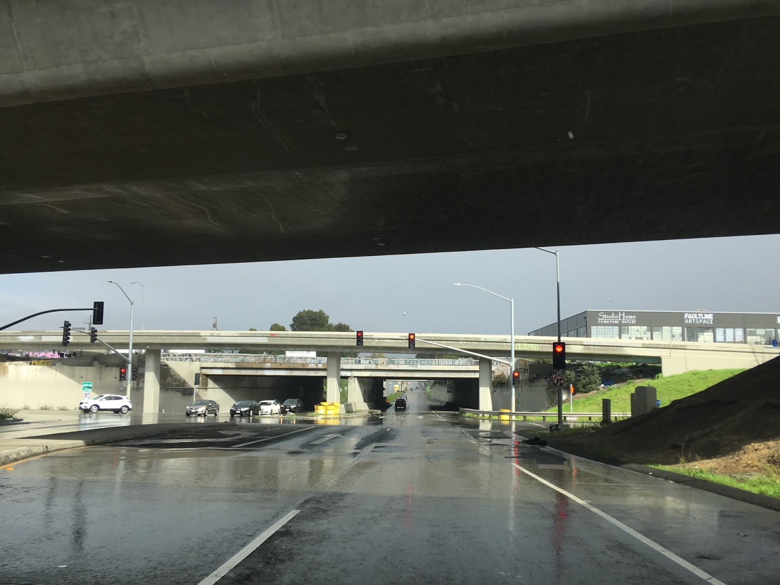
Access to CA 77 can be obtained from I-880 via Exit 38.  Oddly High Street is signed from I-880 and not 42nd Avenue even though that is the direct connection.  From I-880 there is not CA 77 signage, the downpour was about as miserable as it looks.


From the exit ramp CA 77 begins with a left hand turn onto 42nd Avenue.  Again there is no CA 77 shields to be found.


CA 77 east travels under both travel lanes of I-880 and essentially is limited access (albeit not a freeway).


Between the northbound lanes of I-880 and on-ramp from Coliseum Way the first CA 77 reassurance shield appears.   CA 77 east even features an off-ramp to 12th Street which can be seen in the second photo below.


The CA 77 reassurance shield makes it the real "shortest" signed State Highway and not CA 153 which is often proclaimed as such.  My previous blog entry on CA 153 can be found below.

California State Route 153; the supposedly shortest State Highway

CA 77 east even has a second reassurance shield before it terminates at CA 185 at 14th Street.


Comments

Littledots said…
Hi, I was researching the 42nd Ave freeway entrance for my blog and came across your page. Great photos. I am writing a page on the "Bancroft Parkway" which began at the San Leandro border on Bancroft and ended at 42nd Ave with entrance to the Nimitz (880) Freeway. Bancroft Parkway - Oakland Tribune November 25, 1956 -https://www.newspapers.com/clip/67723058/bancroft-parkway-nov-25-1956/
Littledots@yahoo.com

Popular posts from this blog

Dillon Road

Dillon Road is a 34.2-mile highway located in northern Coachella Valley of Riverside County, California.  Dillon Road begins at Avenue 48 on the outskirts of Indio and ends to the west at California State Route 62 near San Gorgonio Pass.  Dillon Road was developed the 1930s as a construction road for the Colorado River Aqueduct.  Dillon Road serves as a northern bypass to much of the development of Coachella Valley.  Dillon Road is known for it's frequent dips and spectacular views of San Gorgonio Pass.   Part 1; the history of Dillon Road Dillon Road was constructed as a haul road for the Colorado River Aqueduct through Coachella Valley.  The Colorado River Aqueduct spans 242 miles from Parker Dam on the Colorado River west to Lake Mathews near Corona.  Construction of the Colorado River Aqueduct began during January 1933 near Thousand Palms and was made functional on January 7, 1939.  West of Berdoo Canyon Road the alignment of Dillon Road is largely concurrent with the Colorado

Tehachapi-Willow Springs Road

Tehachapi-Willow Springs Road is an approximately 21-mile highway located in southeast Kern County.  Tehachapi-Willow Springs Road begins at Tehachapi Boulevard (former US Route 466) in Tehachapi and crosses the Tehachapi Mountains via the 4,820-foot-high Oak Creek Pass.  Tehachapi-Willow Springs Road enters Antelope Valley of the wider Mojave Desert and passes by the historic stage station of Willow Springs to a southern terminus at Rosamond Boulevard.  Tehachapi-Willow Springs Road has historic ties to the Havilah-Los Angeles Road and Stockton-Los Angeles Road due to the once reliable presence of water at Willow Springs. Part 1; the history of Tehachapi-Willow Springs Road Oak Creek Pass and Willow Springs were known to the local tribes of the Tehachapi Mountains for generations.  The first documented European crossing of Oak Creek Pass was during 1776 as part of an expedition by Francisco Garces.  Oak Creek Pass is as used again by John C. Fremont during an 1844-1845 expedition to e

The 1928 Iowa Hill Road Bridge

The 1928 Iowa Hill Road Bridge is a derelict structure located in the Sierra Nevada Mountains of Placer County, California.  The 1928 Iowa Hill Road Bridge can be found between the communities of Colfax and Iowa Hill.  The 1928 Iowa Hill Road Bridge is a wire suspension structure which spans the North Fork American River.  The 1928 Iowa Hill Road Bridge was replaced by a modern span and converted to pedestrian use following floods during 1963.   Part 1; the history of the 1928 Iowa Hill Road Bridge During 1853 gold was discovered at what to become Iowa Hill.  The gold mining claims soon led to a small community known as Iowa City being established.   By 1854, Post Office Service began at the mines of Iowa City.  By 1856 gold production at Iowa City was estimated to be around $100,000.  Iowa City was burned in fires during 1857 and 1862 but the community was rebuilt with more modernized structures.   The location of Iowa City can be seen as "Iowa Hill" on the 1873 Bancroft