
Near the eastern City Limit of Oakland high in the Berkeley Hills one can be find the ruins of the Kennedy Tunnel at the intersection of Old Tunnel Road and Skyline Boulevard. The Kennedy Tunnel opened in 1903 and was the first semi-modern automotive corridor which crossed the Alameda County-Contra Costa County Line. The Kennedy Tunnel even saw service briefly as part of California State Route 24 before the first two bores of the Caldecott Tunnel opened in 1937.
Part 1; the history of the Kennedy Tunnel
The genesis point for California State Route 24 ("CA 24") being extended into the San Francisco Bay Area begins a couple years before the Sign State Routes were announced when Legislative Route Number 75 ("LRN 75") was added by 1931 Legislative Chapter 82. According to cahighways.org the original definition of LRN 75 was as simply "Walnut Creek to Oakland." The instigator for the adoption of LRN 75 was construct a replacement route for the Kennedy Tunnel and Tunnel Road.
The original road from Oakland east over the Berkeley Hills of Alameda County followed a steep ascent via what is now Telegraph Avenue and Claremont Avenue. Upon cresting the Berkley Hills this road would have followed what is now Fish Ranch Road in Contra Costa County. This early road over the Berkeley Hills can be seen departing Oakland in a northeastern direction on the 1878 Thompson & West Map of Alameda County.

In greater detail on the Oakland insert of the 1878 Thompson & West Map of Alameda County. Note; the Summit House which was a stage stop and inn.

This early road over the Berkeley Hills is shown as the "Stage Road to Martinez and Lafayette" on the 1884 William J. Dingee Map of Oakland, Berkeley, and Alameda.

The first known concept for a tunnel through the Berkeley Hills emerged in 1860 but was rejected by the populace in Alameda County and Contra Costa County. Another concept emerged in 1871 as an extension of Broadway via a vaguely described path which would emerge somewhere near San Pablo Creek in Contra Costa County. This 1871 concept would eventually emerge as the route of a choice for a tunnel and would sporadically be under construction during the following decades. Eventually the tunnel construction was taken up by the Merchants Exchange of Oakland which procured the funding and permits to complete construction. The "Inter County Tunnel" was opened November 4th, 1903 and was covered in San Francisco Call Volume 94, Number 158.


Traffic emerging from the Kennedy Tunnel from a Metropolitan Transportation Commission sourced photo.

The median of Tunnel Road and Skyline Boulevard can be seen in this eastward view towards the Kennedy Tunnel.

The Kennedy Tunnel and Tunnel Road can be seen directly south of what Claremont Avenue on the 1912 Reality Union Map of Oakland. Claremont Avenue is noted as "Old Road to Martinez.

The
Kennedy Tunnel drastically cut the travel
time between Oakland-Lafayette by going directly through the Berkeley
Hills. The Kennedy Tunnel was timber lined, narrow and not really in
any way designed with the automobile in mind. Despite being lit by 1914
the Kennedy Tunnel quickly became obsolete and a massive choke point
for increasing automotive traffic. The increasing volume of traffic
using the Kennedy Tunnel was used for justification for inclusion into
the State Highway System as part of LRN 75 in 1931.
Thusly, LRN 75 first appears on the 1932 Division of Highways Map between Walnut Creek-Oakland.
LRN 75 was extended in 1933 and given the following route defintion:
- Oakland to LRN 5 near Stockton via Walnut Creek and Antioch
- LRN 4 near Stockton via Copperopolis to LRN 65 near Altaville
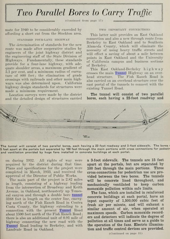
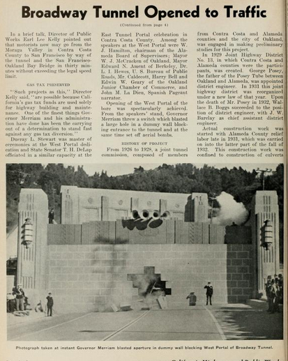
The May 1934 California Highways & Public Works details the design of two bores of the upcoming "Broadway Low Level Tunnel Project." The article goes onto detail a 1926 report spearheaded by Alameda County, Contra Costa County and City of Oakland which showed a need to replace the Kennedy Tunnel. The article goes further in providing detailed drawings of the bores of the Broadway Low Level Tunnels and comparing the planned new alignment of LRN 75 to existing Tunnel Road. Notably; Broadway towards Oakland and Ashby Avenue to Berkeley are cited as major connecting roads to the Broadway Low Level Tunnel Project.


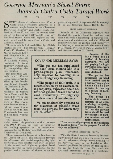
The July 1934 California Highways & Public Works details the ground breaking ceremony for the "Alameda-Contra Costa Tunnel" which took place on June 17th. The ground breaking ceremony was attended by notable figures such as; Governor Frank Merriam and State Director of Public Works Earl Lee Kelly.


The August 1934 California Highways & Public Works announced the initial run of Sign State Routes. CA 24 is noted as beginning at US 99 in Woodland and having a terminus at CA 7 near Reno Junction.


The future extension of CA 24 would see some activity upon the adoption of LRN 206 as part of 1935 Legislative Chapter 630. The initial definition of LRN 206 was from US 40/LRN 69 via Ashby Avenue to LRN 75. Subsequently the extension of CA 24 from the Sacramento Area to San Francisco Bay Area is announced in the October 1935 California Highways & Public Works. Of note; the article cites the new terminus of CA 24 as Oakland instead of Berkeley.


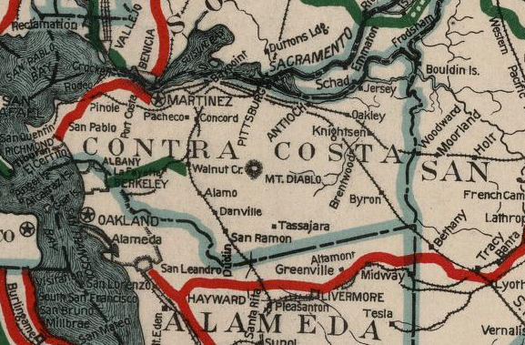
For visual clarity CA 24/LRN 75 east of the Kennedy Tunnel towards Walnut Creek can be seen on the 1935 Division of Highways Map of Contra Costa County.

Ashby Avenue/LRN 206 is shown terminating at LRN 75/Tunnel Road on the 1936 Division of Highways State Map Insert.

This 1936 Shell Highway Map of Oakland shows CA 24/LRN 75 aligned through the Kennedy Tunnel. West of the Kennedy Tunnel CA 24/LRN 75 is shown following; Tunnel Road, Claremont Avenue, College Avenue and Broadway to a terminus at US 40/San Pablo Avenue.


The
opening of the first two bores of the "Broadway Tunnel" and realignment
of CA 24 from the Kennedy Tunnel is discussed in the December 1937 California Highways & Public Works.
Notably; Thomas E. Caldecott the President of Joint Highway District
Number 13 is cited as being honored during the opening ceremonies of the
Broadway Tunnel on December 5th for his contributions. The extension
of Ashby Avenue/LRN 206 is cited to have been part of the Broadway
Tunnel Project.


After the Caldecott Tunnel opened and CA 24 was realigned the Kennedy Tunnel remained open to pedestrian traffic. The Kennedy Tunnel became unstable during the 1940s which led to it's closure. By 1947 the Kennedy Tunnel was sealed off to prevent further access. In the following decades the Kennedy Tunnel collapsed which left only Tunnel Road and the Tunnel Road/Skyline Boulevard median as proof of it's existence. For more on the Caldecott Tunnel and present California State Route 24 see hour blog below:
California State Route 24 and the Caldecott Tunnel
Part 2; visiting the Kennedy Tunnel via Tunnel Road
The December 1937 California Highways & Public Works provides and excellent illustration of what CA 24 looked like when it followed Tunnel Road through the Kennedy Tunnel prior to the completion of the Caldecott Tunnel.

Our drive begins from Caldecott Lane which skirts CA 24 as a northern frontage road. Caldecott Lane merges into Tunnel Road just north of the modern CA 24/CA 13 interchange. My direction of travel on Tunnel Road was eastbound ascending into the Berkeley Hills.


Tunnel Road ascends easterly via a narrow and winding grade. Tunnel Road is signed as a regional bike route and is prone to slip-outs. Upon crossing atop the Caldecott Tunnel the path of Tunnel Road intersects Skyline Boulevard at the median for the Kennedy Tunnel west portal.


Looking east towards the towards the Tunnel Road/Skyline Boulevard median it is hard to envision a tunnel portal just behind it.

The flagpole in the Tunnel Road/Skyline Boulevard median is original to the Kennedy Tunnel and still bears the original Inter County Tunnel plaque.


The E Clampus Vitus historic plaque located in the Tunnel Road/Skyline Boulevard median looks towards where the west portal of the Kennedy Tunnel was located. The plaque in error states that the Inter County Tunnel was renamed to the Broadway Tunnel in 1914, it was actually renamed at that time to the Kennedy Tunnel.


A look where the west portal of the Kennedy Tunnel once stood.


A look west from the Kennedy Tunnel portal reveals how much hill side debris has fallen over the decades. It is hard to fathom this view once being a primary route of travel much less part of CA 24.

Comments