
Exploring New River Gorge and its landmark Bridge


Recently on Gribblenation, we helped break the news that the New River National River and its surrounding lands are to be designated as a National Park & Preserve. Given this exciting news, I thought it would be appropriate to revisit this same area that I had the fortune of exploring for the first time back in July 2020 and show you some of my favorite locations and amenities encountered along the way.

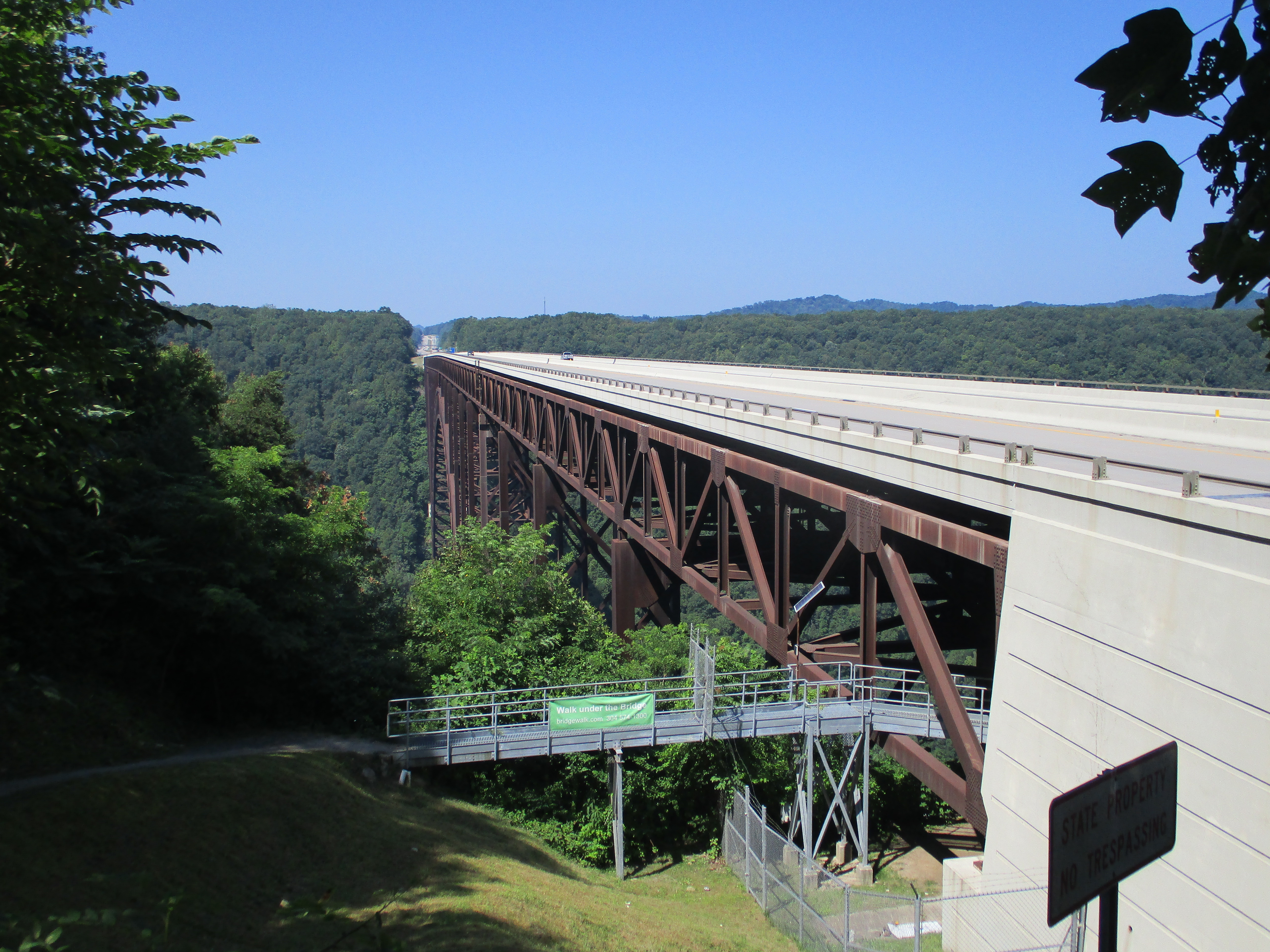
For an engineer like me, the centerpiece landmark of the New River region is the New River Gorge Bridge, a massive steel arch bridge located along US Route 19 near Fayetteville, WV. The bridge was completed in 1977 as the world’s largest bridge of its type, a title it held for 25 years after its completion. It is additionally the centerpiece link in ADHS Corridor L, connecting Interstates 64/77 in Beckley with Interstate 79 near Sutton, and it remains among the great engineering achievements of the 20th Century for both West Virginia and America in general. The bridge’s birthday is celebrated by the locals with the annual “Bridge Day” celebration held on the third Saturday of October. The event attracts folks nationwide and is known for its live demonstrations of rappelling, ascending, and BASE jumping. The eastern bridge landing area is home to a visitor center and a popular overlook point (the location where the picture above was taken). If you’re feeling a bit daring and are unable to attend the “Bridge Day” festivities, you can also sign up for the “Bridge Walk” experience, offered by the private “Bridge Walk, LLC” company. The Bridge Walk gives visitors the opportunity to walk the length of the bridge’s maintenance catwalk beneath the roadway, over 800 feet above the canyon floor. 


Above: Views of the Bridge from various overlook points along the narrow, winding Fayette Station Road. The bridge's steel arch spans 1,700 ft and its roadway stands 876 ft above the canyon floor, making it among the tallest bridges in the United States.

For a bit of a change of pace, drivers can also navigate their way along the Old Road across New River Gorge. Signed today as Fayette Station Road and Fayette County Route 82, the old road is a single lane wide (open to traffic in the south/westbound direction) and navigates the steep slopes of the gorge with the help of tight hairpin turns and switchbacks. At the bottom of the gorge, the old road crosses the New River on a single-lane truss bridge known as the Fayette Station Bridge. The bridge was built in 1889 and then closed upon completion of the New River Gorge Bridge in 1977. After 20 years of abandonment, the bridge and Fayette Station Road were reopened to small vehicle traffic in 1997 and this bridge at the bottom of the gorge offers a spectacular view of the newer arch bridge as it soars over 800 feet above.

Above: A few images of the Fayette Station Road as it winds its way through New River Gorge, including the Fayette Station Bridge at the bottom of the canyon.

The above photos come from my "Bridge Walk" trip as we walked the length of the maintenance catwalk beneath the roadway. In spite of the heights we were at, the walk is extremely safe - walkers wear lanyards that tie off to an overhead tag line to prevent falls. The catwalk itself also has waist-high railings on it so folks won't fall off the edges. It's one of the safer catwalks I've had the pleasure of strolling as an engineer, but the heights we deal with at this particular location are enough to frighten even the most skilled thrill-seekers.

It’s not just all about roads and bridges when you’re here - there are other non-road related locations folks can check out while they’re in the area. In July 2020, the above-mentioned Visitor Center was closed due to COVID-19, so I sought out other alternative ways to take advantage of what the area has to offer. One of my favorite activities during this visit was to hike the Long Point Trail, which is a 2.9 mile out & back from a trailhead located just south of Fayetteville village. It’s a fairly stress-free hike that takes about 90 minutes round-trip at a brisk pace and the views at the overlook at trail’s end are some of the finest in the entire New River region, spectacular even. It’s one of those simple ways to do something outdoors while still maintaining social distance in the era of COVID-19, while also taking in the man-made & natural scenery & beauty of New River.


Above: Select views of the Long Point Trail near Fayetteville, including the "Money Shots" of the Bridge at the Trail's End Overlook


Comments

Popular posts from this blog

Paper Highways: The Unbuilt New Orleans Bypass (Proposed I-410)

  There are many examples around the United States of proposed freeway corridors in urban areas that never saw the light of day for one reason or another. They all fall somewhere in between the little-known and the infamous and from the mundane to the spectacular. One of the more obscure and interesting examples of such a project is the short-lived idea to construct a southern beltway for the New Orleans metropolitan area in the 1960s and 70s. Greater New Orleans and its surrounding area grew rapidly in the years after World War II, as suburban sprawl encroached on the historically rural downriver parishes around the city. In response to the development of the region’s Westbank and the emergence of communities in St. Charles and St. John the Baptist Parishes as viable suburban communities during this period, regional planners began to consider concepts for new infrastructure projects to serve this growing population.  The idea for a circular freeway around the southern perimeter of t

Hernando de Soto Bridge (Memphis, TN)

The newest of the bridges that span the lower Mississippi River at Memphis, the Hernando de Soto Bridge was completed in 1973 and carries Interstate 40 between downtown Memphis and West Memphis, AR. The bridge’s signature M-shaped superstructure makes it an instantly recognizable landmark in the city and one of the most visually unique bridges on the Mississippi River. As early as 1953, Memphis city planners recommended the construction of a second highway bridge across the Mississippi River to connect the city with West Memphis, AR. The Memphis & Arkansas Bridge had been completed only four years earlier a couple miles downriver from downtown, however it was expected that long-term growth in the metro area would warrant the construction of an additional bridge, the fourth crossing of the Mississippi River to be built at Memphis, in the not-too-distant future. Unlike the previous three Mississippi River bridges to be built the city, the location chosen for this bridge was about two

Huey P. Long Bridge (New Orleans, LA)

Located on the lower Mississippi River a few miles west of New Orleans, the Huey P. Long Bridge is an enormous steel truss bridge that carries both road and rail traffic on an old-time structure that is a fascinating example of a bridge that has evolved in recent years to meet the traffic and safety demands of modern times. While officially located in suburban Jefferson Parish near the unincorporated community of Bridge City, this bridge’s location is most often associated with New Orleans, given that it’s the largest and most recognizable incorporated population center in the nearby vicinity. For this reason, this blog article considers the bridge’s location to be in New Orleans, even though this isn’t 100% geographically correct. Completed in 1935 as the first bridge across the Mississippi River in Louisiana and the first to be built in the New Orleans area, this bridge is one of two bridges on the Mississippi named for Huey P. Long, a Louisiana politician who served as the 40th Gove