The Arroyo Seco Parkway is an 8.16-mile section of freeway which traverses from the FourLevel Interchange in downtown Los Angeles northward to Pasadena. The Arroyo Seco Parkway is currently designated as part of California State Route 110 but is more widely known as being a classic component of US Route 66. While US Route 66 used the entirety of the Arroyo Seco Parkway the freeway also carried US Route 6, US Route 99 and California State Route 11 at different points throughout its long history. The Arroyo Seco Parkway is one of the oldest freeways in the United States. Featured as the blog cover is Figueroa Street at Solano Avenue in 1940 before the Figueroa Street Tunnels were converted to northbound service on the Arroyo Seco Parkway.
Part 1; the development of the Arroyo Seco Parkway and attempting to resolve the early western terminus points of US Route 66
The earliest route description of US 66 by the American Association of State Highway Officials (AASHO) has the highway technically ending in San Fernando. The AASHO had approved the creation of the US Route System on November 11th, 1926.
Note: the responsibility of designating and approving movements of the US Routes has always been under the scope the AASHO (and modern AASHTO). The early history of the western terminus of US 66 has numerous parties and factors contributing to its movements which fall outside of the supervision of the AASHO. This blog has far more conjecture than I would like but it is clear that a great deal of movement was at-foot with US 66 around Los Angeles without AASHO approval. My recommendation would be to always follow the official definitions of US Routes provided by the AASHO. Nonetheless this blog will attempt to examine all angles to the narrative of early western terminus of US 66.
Notably the original terminus of US 66 within Los Angeles is generally cited to have been located at 7th Street and Broadway. 7th Street and Broadway is the known terminus of the Los Angeles branch of the National Old Trails Road (NOTR).
In April of 1912 the NOTR was organized with the goal of signing a trans-continental highway between Baltimore and Los Angeles. Building a modern road for automotive use through the Mojave Desert of California would prove to be particularly difficult as State Highway Maintenance didn't exist, and the general path of travel was alongside the service routes of railroads. The first Auto Trail through Cajon Pass was the Santa Fe-Grand Canyon Needles National Highway which was first signed in Cajon Pass by 1913. NOTR organizers later adopted the routing of the Santa Fe-Grand Canyon Needles National Highway in the western United States by 1914.
The Auto Club of Southern California (ACSC) July 1914 Touring Topics magazine discussed the ongoing efforts to sign the NOTR between downtown Los Angeles and Kansas City (courtesy Stan Penton).
The ACSC signed the NOTR in downtown Los Angeles with California Metal Enameling Company sourced signage. The example below is a photo of one of the remaining guide signs which were once found in downtown (courtesy Stan Penton). The standard NOTR shield was a grey diamond which displayed the name of the highway along with a cross-country map.
Later era ACSC signage can be seen below at 7th Street and Broadway in a 1935 era photo. The photo omits references to the NOTR likely due to it being dated well into the service life the US Route System.
The NOTR was able secure funding to pave the route through Cajon Pass and construct the 1914 Crowder Canyon Bridge. The construction of the NOTR through Cajon Pass provided direct automobile access to the Inland Empire and Los Angeles Basin.
From San Bernardino beginning at Mount Vernon Avenue/4th Street the NOTR followed existing LRN 9 westbound to Pasadena. Upon reaching Pasadena the NOTR branched away from LRN 9. The NOTR westbound jogged south on Santa Anita Avenue to Colorado Boulevard in Pasadena and departed towards Los Angeles via Fair Oaks Avenue. The NOTR followed Fair Oaks Avenue, Huntington Drive and Broadway into downtown Los Angeles where it terminated at the intersection of 7th Street and Broadway. The early NOTR can be seen on the 1916 National Old Trails Road map developed by the ACS).
According to the California Historic Route 66 Association pre-1932 ACSC records indicate that the routing of early US 66 was concurrent with that of the NOTR between Pasadena and Los Angeles. In that sense it would be fair to say that 7th Street and Broadway as the original terminus of US 66 was simply an overlay of NOTR. It is unclear if the ACSC ever replaced NOTR signage with US 66 to 7th Street and Broadway, but the Los Angeles City Council minutes suggest they did not (see below for February 5th, 1930).
The initial draft of the US Route System was approved by the Secretary of Agriculture during November of 1925. The US Route System within California was approved by California Highway Commission with no changes recommended which can be seen in the January 1926 California Highways & Public Works. Planned US Route 60 is stated to be planned to follow the NOTR from the Arizona State Line to a terminus in Los Angeles. This only California Highways & Public Works to infer US 60 (and US 66) was planned to completely overlay the NOTR. At this point the Chicago-Los Angeles US Route was still planned to be designated US 60. US 60 of course would become US 66 when the US Route System was finalized on November 11th, 1926.
The location of the western terminus of US 66 was a source of much contention during the establishing years of the US Route System. In a letter dated March 1st, 1927, from California State Highway Engineer R.M. Morton replied to AASHO Executive Secretary W.C. Markham conveying it was the understanding of the California Highway Commission that US 66 ended in San Fernando.
In a letter dated April 21st, 1927, from California State Highway Engineer R.M. Morton writes to AASHO Executive Secretary W.C. Markham regarding numerous US Route topics. The western terminus of US 66 in San Fernando, how US 66 did not touch the City Limits of Los Angeles and the omission of Pasadena from the US 66 Route Description are expounded upon. Notably R.M. Morton states the description of US 99 would have it jog south into Los Angeles and then follow a multiplex of US 66 east to San Bernardino.
On April 26th, 1927, AASHO Executive Secretary W.C. Markham wrote in a letter to California Highway Commission Office Engineer L.T. Cambell stating it would be preferable to have US 66 end somewhere in Los Angeles. W.C. Markham noted US 66 was already being promoted as the primary highway between Chicago and Los Angeles. W.C. Markham goes onto suggest that it would be helpful if signage of the western terminus of US 66 was placed in the nearest convenient location within the City of Los Angeles. The terminus of US 66 in San Fernando is described as a technical error and that the last city on the Route Description should be Los Angeles.
Thusly US 66 is displayed in the January 1928 California Highways & Public Works as terminating in Los Angeles via San Fernando. This seems to imply US 66 was to be signed somewhere via multiplex of US 99 on San Fernando Road into the City Limits of Los Angeles.
Note, prior to 1933 the Division of Highways was not actively involved in maintaining urban highways outside of occasional cooperative projects. The responsibility for signage of US Routes in cities was thusly given to the ACSC in the Southern California region.
In the early US Route era amid the confusion as to the location of US 66 in Los Angeles the city of Santa Monica is shown to have desired to extend the highway into their boundaries. In the May 31st, 1928, Santa Monica Outlook (courtesy MapMikey) an article notes the city of Santa Monica was planning to send delegates to the June 6, 1928, US Route 66 Association convention Flagstaff in attempt to secure the western terminus of the highway.
The June 18th, 1929, Santa Monica Outlook (courtesy MapMikey) announced Los Angeles intended to aid the city of Santa Monica in signing US 66 to their boundaries. The Los Angeles city engineer John C. Shaw was directed by the Los Angeles City Council to cooperate with extending US 66 to Santa Monica. US 66 is noted in the article to be currently signed to western terminus at the Los Angeles/Pasadena city limit at the western edge of the Colorado Street Bridge. A planned routing for US 66 through Los Angeles to Santa Monica is described as following Pasadena Avenue, York Boulevard, Eagle Rock Boulevard, Fletcher Drive, Glendale Boulevard, Rowena Avenue, Hyperion Avenue, Fountain Avenue and Myra Avenue. No planned terminus for US 66 in Santa Monica is cited in the article.
The 1930 Division of Highways Map notably seems to follow the AASHO description of US 66 given in the January 1928 California Highways & Public Works. US 66 is shown terminating at US 99 near San Fernando which would have barely skirted the City of Los Angeles.
The Los Angeles City Council meeting notes (courtesy MapMikey) from February 5th, 1930, explicitly state that the US Routes were not yet signed within Los Angeles. The Los Angeles City Council did elect have the ACSC sign US 99 and US 101 during the February 5th, 1930, meeting but not US 66. The rationale by the Los Angeles City Council for not having the ACSC sign US 66 was due to the uncertainty of the location of the highway.
The Los Angeles City Council Minutes on January 12th, 1931, provide context to the initial signing of US 66 through Los Angeles. During 1930 the City of Santa Monica petitioned the Los Angeles City Council to have the ACSC sign US 66 through Los Angeles to their city limit at their expense. The Los Angeles City Council approved the request to allow the ACSC to sign US 66 to Santa Monica on December 15th, 1930. The Los Angeles City Council notably did not petition the California Highway Commission or AASHO regarding the signing of US 66 to Santa Monica.
The ACSC signage of US 66 within the City of Los Angeles is stated to have begun on Colorado Boulevard at the Los Angeles/Pasadena City Lines. US 66 is stated to follow Colorado Boulevard, Eagle Rock Boulevard (formerly Glassell Avenue), and Fletcher Drive to US 99 at San Fernando Road. US 66 is stated to continue westward via Glendale Boulevard, Rowana Boulevard, Hyperion Avenue, Myra Avenue, the viaduct under Sunset Boulevard and Santa Monica Boulevard to the city of Santa Monica. The Los Angeles City Council Minutes do not describe where US 66 was signed to in Santa Monica.
Note: Fletcher Drive was completed between Eagle Rock Boulevard and San Fernando Road which can be seen in announced on a January, 26th 1929 newspaper.
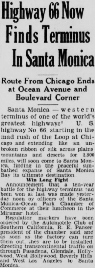
The January 27th, 1931, Santa Monica Outlook (courtesy MapMikey) announced US 66 had been signed through Santa Monica. The article details the alignment of US 66 in Santa Monica as following Santa Monica Boulevard to a terminus at Ocean Avenue.
The AASHTO Database file for 1931 shows a letter dated April 7th which illustrates the California Highway Commission and AASHO had become aware of US 66 being signed through Los Angeles to Santa Monica. California State Highway Engineer C.H. Purcell acknowledges in a response letter to the AASHO Executive Secretary that the US 66 signage Santa Monica was not officially approved by the AASHO and had been placed by the ACSC at the behest of the City of Los Angeles and Los Angeles County. C.H. Purcell notes the ACSC had agreed to withdraw US 66 signage from the city limit of Santa Monica. No officially established western terminus of US 66 is discussed in the exchange of letters.
The May 19th, 1931, Santa Monica Outlook (courtesy MapMikey) announced the removal of the US 66 signs in Santa Monica. The article stub notes the dissatisfaction of the Santa Monica City Council in having the signage of US 66 withdrawn by State orders to Los Angeles.
The November 6th, 1931, Santa Monica Outlook (courtesy MapMikey) announced Edgar Knight of the US 66 Grand Canyon-Boulevard Dam Highway Association met with the Santa Monica Chamber of Commerce to discuss promoting Santa Monica as the western terminus of US 66.
The December 15th, 1931, Santa Monica Outlook (courtesy MapMikey) expresses the lamentation of the Santa Monica Chamber of Commerce of having US 66 signage removed to Los Angeles.
Below is an exchange of letters dated to November/December 1931 between C.H. Purcell the California State Highway Engineer and W.C. Markham Executive Secretary of the AASHO. Markham conveys a desire to split US 66 into a mainline routing terminating at US 101 in downtown Los Angeles at Sunset Boulevard via Broadway and an Alternate Route which bypassed downtown towards US 101 at Sunset Boulevard via Hyperion Avenue. The AASHO recommended extending US 66 to Santa Monica so that they Mainline and Alternate Route would have a meet up point via US 101.
Ultimately Markham appears to have been not in favor of having US 66 ending in Santa Monica whereas the AASHO didn't want dual terminus points. Of note, the documents below show US 66 signage had been retracted by the ACSC from Santa Monica to a terminus point at US 99/San Fernando Road via Fletcher Drive. Despite US 66 being signed to an endpoint at San Fernando Drive via Fletcher Drive there seemingly was never an approval to make it the official terminus by the AASHO Executive Committee. It is not clear when signage of US 66 was shifted from a signed terminus at San Fernando Road and Fletcher Drive.
The first three Figueroa Street Tunnels opened between Riverside Drive and Solano Avenue in October of 1931 which routed traffic through Elysian Park. The Figueroa Street Tunnels would ultimately end up becoming a key piece of the future Arroyo Seco Parkway and resolving an official terminus of US 66 in Los Angeles.
1933 was a landmark year in terms of Statewide transportation. The State Legislature removed restrictions that prevented State Funds from being used to maintain urban roadways. This change by the Legislature led to the addition of numerous urban highways being adopted.
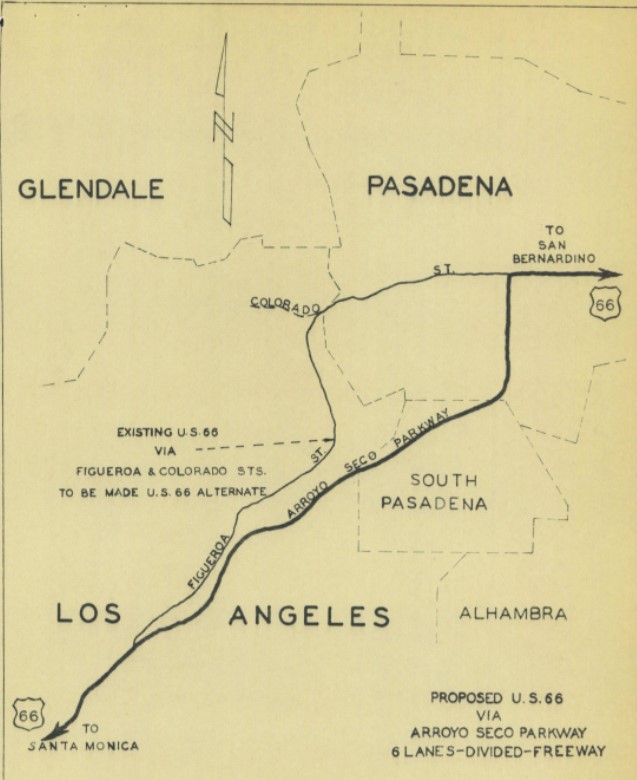
One of the 1933 additions to the State Highway system was Legislative Route Number 165 (LRN 165) which was routed from San Pedro to La Canada via Figueroa Street. The addition of LRN 165 made the three completed Figueroa Street Tunnels part of the State Highway system and led to the construction of the fourth southernmost tunnel. Figueroa Street once completed between Pasadena and downtown Los Angeles would serve as a much more direct corridor with more traffic capacity than earlier NOTR.
Much of the early US Route system around Los Angeles was heavily altered after 1933. During 1934 US 99 was realigned off a multiplex of US 66 from Pasadena-San Bernardino (LRN 9) to a new alignment which took it to Redlands via downtown Los Angeles, Pomona and Colton on LRN 26. The attached sketch map implies US 66 was aligned through the Figueroa Street Tunnels, Solano Avenue and Broadway to a terminus at US 101/Sunset Boulevard.
CAhighways.org has a page dedicated to I-110/CA 110 which shows a photo of the fourth Figueroa Street Tunnel under construction. Temporary signage showing US 66/US 99 and California State Route 11 can be seen in front of the tunnel which is looking southbound. The Temporary signage shows US 99/US 66 and California State Route 11 (CA 11) jogging from the fourth Figueroa Street Tunnel onto Solano Street onwards to Broadway. Note: CA 11 was one of the initial Sign State Routes announced in the August 1934 California Highways & Public Works.
On June 14th, 1935, the California State Highway Engineer submitted a request to extend US 66 from the intersection of Broadway and Sunset Boulevard in Los Angeles to the intersection of Lincoln Boulevard and Pennsylvania Avenue in Santa Monica.
The California State Highway Engineer acknowledges in a letter dated to July 6th, 1935, that the AASHO Executive Committee had approved the extension of US 66 to Santa Monica. The California State Highway Engineer conveyed a desire to delay the announcement of the extension of US 66 until US 6 had been extended to Long Beach. It is unclear why the approval of US 6 to California would impact the announcement of the extension of US 66 to Santa Monica.
Amusingly the Santa Monica Chamber of Commerce had already announced the formal extension of US 66 which can be seen in the July 2nd, 1935, Santa Monica Outlook. The article stub notes US 66 was to be extended back to Ocean Avenue via Santa Monica Boulevard. The article notes the change of California State Route 3 on Roosevelt Highway to US 101A as being critical in making the extension of US 66 to Santa Monica Official.
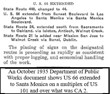
The October 1935 California Highways & Public Works announced US 66 was extended to US 101A in Santa Monica via LRN 162
An opening ceremony for the fourth Figueroa Street Tunnel was held on August 4th of 1936 which was featured in the Los Angeles Times. The completion of the fourth Figueroa Street Tunnel connected US 99/US 66/CA 11/LRN 165 directly to US 101/LRN 2 at Sunset Boulevard.
The August 1936 California Highways & Public Works announced plans for the North Figueroa Street Viaduct and details the planned Arroyo Seco Parkway (LRN 205). The North Figueroa Street Viaduct would eliminate the jog in US 99/US 66/CA 11/LRN 165 on Arroyo Seco Boulevard and Riverside Drive. Note: LRN 205 and the Arroyo Seco Parkway were defined by 1935 Legislative Chapter 426 as a State Highway.
A letter dated February 8th, 1937, by the AASHO Executive Secretary to the State Highway Engineers of; Colorado, Nevada and California announced the approved extension of US 6 from Greeley, Colorado to Long Beach, California. The extension of US 6 to Long Beach was carried via multiplex of US 99/LRN 4 from San Fernando Pass south onto San Fernando Road and US 99/US 66/CA 11/LRN 165 via the Figueroa Street Tunnels to downtown Los Angeles.
The April 1937 California Highways & Public Works features construction of the North Figueroa Street Viaduct over the Los Angeles River. The North Figueroa Street Viaduct is stated in the article stub to be nearing completion.
US 99/US 66/US 6/CA 11/LRN 165 can be seen realigned over the North Figueroa Street Viaduct on the 1938 Division of Highways Map. US 99/US 6 are shown being realigned onto Avenue 26 approaching the North Figueroa Street Viaduct.
The partially completed Figueroa Street/Temple Street underpass is shown in the November 1939 California Highways & Public Works. The article stub notes the Arroyo Seco Parkway was anticipated to be completed during 1941.
The August 1940 California Highways & Public Works announced the opening of a 3.7-mile unit of the Arroyo Seco Parkway from Orange Grove Avenue in south Pasadena to Avenue 40 in Los Angeles. The initial segment of the Arroyo Seco Parkway served as a new alignment of US 66.
On September 7th, 1940, the California State Highway Engineer submitted a request to reroute US 66 onto the Arroyo Seco Parkway and redesignate older route on Figueroa Street co-signed with CA 11 as US 66A. On October 9th, 1940, the AASHO Executive Secretary responded and advised that seeking AASHO approval to reroute US 66 was unnecessary given the rerouting was entirely in a California Metropolitain Area. While not directly stated the AASHO Executive Secretary did not disapprove of the existence of US 66A.
The November 1940 California Highways & Public Works featured the completed extension of the Arroyo Seco Parkway south to Avenue 22 near the Los Angeles River. The extension of the Arroyo Seco Parkway to Avenue 22 was completed by November 1st, 1940 and include the new interchanges with US 99/US 6 and CA 11.
The completed Arroyo Seco Parkway between Los Angeles and Pasadena is featured in the January 1941 California Highways & Public Works. The Arroyo Seco Parkway is stated to have been dedicated on December 30th, 1940, Governor Culbert L. Olson. The Arroyo Seco Parkway is stated to be the first freeway in the western United States serving as a direct limited access link between Los Angeles and Pasadena. The Arroyo Seco Parkway terminated at Avenue 22 where US 99/US 6/US 66/CA 11 continued south into Los Angeles via the North Figueroa Street Viaduct and Figueroa Street Tunnels. US 99 was carried via multiplex of US 66/US 6/CA 11/LRN 165 between Avenue 22 south on the Arroyo Seco Parkway to US 101/LRN 2 at Sunset Boulevard/Macy Boulevard.
The April 1941 California Highways & Public Works detailed the planned extension of the Arroyo Seco Parkway south from Avenue 22 to Adobe Street in Los Angeles. The extension of the Arroyo Seco Parkway included incorporating the existing Figueroa Street Tunnels as northbound travel lanes whereas new excavated southbound lanes were in the process of being constructed. The extension of the Arroyo Seco Parkway is stated to be a cooperative project between the State of California and the Federal Government.
The September 1941 California Highways & Public Works notes the Arroyo Seco Parkway extension had been designated a Defense Highway Project. The designation as a Defense Highway Project would ensure the Arroyo Seco Parkway extension was kept as a priority highway project in the event the United States would be pulled into World War II (spoiled, see what transpired on December 7th, 1941).
The July 1942 California Highways & Public Works features new ramp divider structures recently installed on the Arroyo Seco Parkway. The dividers are stated to be intended to prevent wrong-way entrances to the Arroyo Seco Parkway.
The November/December 1943 California Highways & Public Works features ongoing construction of the Los Angeles River Bridge along the southbound lanes of the Arroyo Seco Parkway extension to downtown Los Angeles.
The January/February 1944 California Highways & Public Works features the extension of the Arroyo Seco Parkway south to downtown Los Angeles to Adobe Street. The extension of the Arroyo Seco Parkway moved US 99/US 66/US 6/CA 11/LRN 165 to a new freeway structure between Avenue 22 and Adobe Street. The existing Figueroa Street Tunnels were converted to northbound freeway usage whereas new southbound lanes were routed via the new Los Angeles River Bridge and an excavated cut. The extension of the Arroyo Seco Parkway opened to traffic on December 30th, 1943.
The extended Arroyo Seco Parkway as part of US 99/US 66/US 6/CA 11/LRN 165 can be seen on the 1944 Division of Highways Map.
The May/June 1944 California Highways & Public Works features the conceptual Four Level Interchange. The Four Level Interchange as planned would permit direct limited access travel between the Arroyo Seco Parkway, Hollywood Parkway, Santa Ana Parkway and Harbor Parkway. in downtown Los Angeles.
The January/February 1949 California Highways & Public Works features an update on the construction of the Four Level Interchange. The Four Level Interchange is stated to be nearing completion. The article stub notes the Four Level Interchange would link the Arroyo Seco Parkway via a limited access grade to the Hollywood Parkway and Harbor Parkway. Construction of the Four Level Interchange once complete would eventually link the Arroyo Seco Parkway south from Adobe Street.
The March/April 1953 California Highways & Public Works notes the Arroyo Seco Parkway was expected to be completed to the Four Level Interchange by summer 1953. The completion of the Arroyo Seco Parkway to the Four Level Interchange would provide full freeway access through the structure for the first time.
The 1954 Division of Highways Map displays the completed segment of US 99/US 66/US 6/CA 11/LRN 165 on the Arroyo Seco Parkway to the Four Level Interchange. US 99/US 101/LRN 2 are shown moved to the completed Santa Ana Freeway and Aliso Street Bridge over the Los Angeles River. The completed Ramona Freeway alignment of US 99/US 60/US 70/LRN 26 from the Aliso Street Bridge to Alhambra is displayed. The planned Ramona Freeway extension of US 99/US 60/US 70/LRN 26 can also be seen.
The 1957 Division of Highways City Insert is the first year the name "Pasadena Freeway" appears. US 66A also makes its first appearance co-signed with CA 134 on Colorado Boulevard and CA 11 on Figueroa Street.
By 1961 the Golden State Freeway is shown on the State Highway Map City insert connecting to the Pasadena Freeway. US 99 is still shown multiplexing US 6/US 66/CA 11 on the Pasadena Freeway to the Four Level Interchange in 1961.
The 1962 State Highway Map City insert shows the Golden State Freeway bypass of downtown Los Angeles was completed. Consequently US 99 is shown being routed off the Pasadena Freeway onto the new Golden State Freeway bypass of downtown Los Angeles
During 1964 the California State Highway Renumbering took affect which would heavily impact the Pasadena Freeway corridor. The 1964 California State Highway Renumbering eliminated Legislative Route Numbers in favor of field signage, minimized multiplexes, eliminated US Routes which didn't cross the State Line and assigned field signage to former Legislative Route Numbers which lacked it.
The truncation of US 6 from Long Beach to Bishop was approved by the AASHO Executive Committee on June 19th, 1963. The truncation of US 6 to Bishop removed it from the Pasadena Freeway and Golden State Freeway.
US 66 was approved to be truncated from Santa Monica to US 95 in Needles by the AASHO on November 14th, 1963. US 66 was effectively immediately removed from the Pasadena Freeway with signage being truncated to Pasadena. This measure left only CA 11 as the only signed highway on the Pasadena Freeway. Signage of US 66 would not be truncated from Pasadena to US 95 until I-40 was completed through the Bristol Mountains in 1972.
US 66A which was concurrent with CA 11 between the Arroyo Seco Parkway and Pasadena was approved to be deleted by the AASHO Executive Committe on October 20th, 1963.
The 1964 Division of Highways Map reflects the changes to the US Routes associated with Pasadena Freeway related to the 1964 State Highway Renumbering. US 6 was truncated off the Pasadena Freeway and out of the Los Angeles area to Bishop whereas US 99 was truncated to downtown Los Angeles from Calexico. US 66 was truncated off the Pasadena Freeway from Santa Monica all the way back to Pasadena. US 66A was removed entirely and CA 11 was shifted off its surface alignment north of the Golden State Freeway. CA 11 was subsequently moved to the entirety of the Pasadena Freeway with its former surface portion on Figueroa Street becoming CA 159.
1981 Legislative Chapter 292 defined all of CA 11 on the Pasadena Freeway and Harbor Freeway as "Route 110." CA 110 was applied to the entirety of the Pasadena Freeway and the Harbor Freeway south through downtown Los Angeles to I-10. The Harbor Freeway south of I-10 was assigned as the second iteration of I-110. The Harbor Freeway south of I-10 had been designated an Interstate corridor as part of the Surface Transportation Assistance Act of 1978. The entire Pasadena Freeway can be seen legislatively assigned as CA 110 on the 1982 Caltrans Map.
During 2010 the Pasadena Freeway was redesignated as the Arroyo Seco Parkway. The Arroyo Seco Parkway was added to the National Register of Historic Places during 2011. The Arroyo Seco Parkway is one of the few segments of US 99 to be added to the National Register of Historic Places.
Part 2; visiting 7th Street and Broadway
In 2019 I visited downtown Los Angeles to visit 7th Street and Broadway. Upon my arrival in downtown Los Angeles, I parked on Bunker Hill and made way eastward towards Broadway. Along the way I checked out the east portals of the 2nd Street Tunnel and 3rd Street.
After descending Bunker Hill via 2nd Street to Broadway. Once on Broadway I began walking towards the 7th Street.
At the southeast corner of Broadway and 3rd Street is the location of the Bradbury Building. The Bradbury Building is a five-story high rise office building constructed in 1893 which has become a designated US 66 landmark. The Bradbury Building is mostly known for being the location of several scenes in the movie Blade Runner.
Broadway is signed with various marques directing pedestrian traffic to the numerous districts of downtown Los Angeles. Despite ssome modern skyscrapers popping up in the background the look of Broadway still fits the feel of what one might assume to see on an early urban US Route.
At Broadway and 7th Street I met what was in ACSC records once as the original terminus of US 66 and for certain the Los Angeles branch of the NOTR
Suffice to say there are many errors on the above placard as illustrated in Part 1. When I took this picture in 2019, I was certain that 7th Street and Broadway was the original terminus of US 66. Suffice to say three years of research (this blog was originally published on 6/10/19 and is being updated on 2/27/22) really has cast doubt if 7th Street and Broadway was signed as anything but terminus of the Los Angeles branch of the NOTR. Regardless of what was going with the terminus of US 66 the terminus NOTR is of enough historical importance that it probably should be celebrated.
Part 3; a drive on the Arroyo Seco Parkway
My approach to the Arroyo Seco Parkway was from 9th Street onto CA 110 north on the Harbor Freeway. The Harbor Freeway north of Interstate 10 to the Four Level Interchange is not compliant with Interstate standards and thus signed as CA 110.
Exit 23A on CA 110/Harbor Freeway northbound accesses 6th Street.
Exit 23B on CA 110/Harbor Freeway northbound accesses 4th Street whereas 3rd Street is accessed via Exit 23C.
CA 110/Harbor Freeway northbound approaches the Four Level Interchange. Access to the Santa Ana Freeway is presently signed as US 101 south to Interstate 5/Interstate 10/CA 60 whereas it once was US 99/US 101 south. Access to the Hollywood Freeway is signed as US 101 north whereas it would have once been US 101 north/US 66 west. CA 110 continues northward onto the Arroyo Seco Parkway and would have once carried; US 66 east/US 6 east/US 99 north/CA 11 north. Truck traffic is advised of they are prohibited on the Arroyo Seco Parkway. The truck prohibition on the Arroyo Seco Parkway dates back to 1943.
The Arroyo Seco Parkway begins north of the Four Level Interchange. The older character of the Arroyo Seco Parkway is evident immediately due to the button-copy signage and older Arc Deco bridge structures. CA 110 north on the Arroyo Seco Parkway accesses Stadium Way via Exit 24.
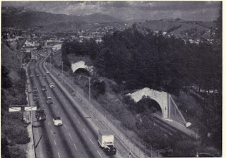
CA 110 north on the Arroyo Seco Parkway proceeds into the 1936 Figueroa Street Tunnel. The 1936 Figueroa Street Tunnel is the longest of the four tunnels at 755 feet in length. Academy Road and Solano Avenue are signed as being accessible from Exit 25. Before the completion of the fourth Figueroa Street Tunnel the alignment of US 66/US 99/CA 11 made a right-hand turn towards Broadway via Solano Avenue.
The next three Figueroa Street Tunnels were completed in 1931. The next northward tunnel is 461 feet in length.
The third Figueroa Street Tunnel northward is the shortest at 130 feet in length.
The fourth northernmost Figueroa Street Tunnel is 405 feet in length. I-5 north traffic is directed to use Exit 26A from the left.
CA 110 north on the Arroyo Seco Parkway crosses the Los Angeles River via the 1937 North Figueroa Street Viaduct. The junction for US 66 with US 6/US 99/CA 11 before the Arroyo Seco Parkway was built can be located via Exit 26B onto Figueroa Street which connects with San Fernando Road/Avenue 26.
CA 110 north traffic crosses under Avenue 26 and is greeted by Historic Arroyo Seco Parkway signage.
CA 110 north Exit 27 on the Arroyo Seco Parkway accesses Avenue 43.
CA 110 north Exit 28A on the Arroyo Seco Parkway accesses Avenue 52 whereas Exit 28B accesses Via Marsiol.
Exit 29 on CA 110 north/Arroyo Seco Parkway accesses Avenue 60.
Marmion Way and Avenue 64 are accessed from CA 110 north/Arroyo Seco Parkway Exit 30A.
CA 110 north/Arroyo Seco Parkway Exit 30B accesses Bridewell Street.
CA 110 north/Arroyo Seco Parkway north crosses the Arroyo Seco into San Gabriel Valley. Traffic is advised that the Rose Bowl can be reached via the following three exits.
Orange Grove Avenue is accessed from CA 110 north/Arroyo Seco Parkway Exit 31A whereas Fair Oaks Avenue is accessed via Exit 31B.
CA 110 and the Arroyo Seco Parkway terminate at Glenarm Street in Pasadena.
US 66 and LRN 205 continued north past the terminus of the Arroyo Seco Parkway on the surface street known as Arroyo Parkway to Colorado Boulevard where US 66A would have been met. I headed as far north as Green Street where I followed signage to Interstate 210.
Part 4; Roadwaywiz on the Arroyo Seco Parkway
During September 2020 Dan Murphy of the Roadwaywiz YouTube Channel and Gribblenation featured real-time drives on the Arroyo Seco Parkway. Below the northbound Arroyo Seco Parkway can be viewed.
Below the southbound Arroyo Seco Parkway can be viewed.
During May 2020 the Arroyo Seco Parkway was featured as part of the Roadwaywiz Los Angeles Webinar. The Arroyo Seco Parkway is discussed by panelists Dan Murphy, Scott Onson and Steve Alps at 41:00-50:54.
Part 5; visiting the signed terminus location of US Route 66 at Fletcher Drive and San Fernadno Road
After US Route 66 was shifted towards Broadway and Sunset Boulevard it's former terminus on Fletcher Drive would become part of California State Route 2. The Sign State Routes were announced during August 1934 and the alignment of California State Route 2 incorporated much of the early signed routing US Route 66 in Los Angeles. California State Route 2 can be seen crossing US Route 99 westbound at the intersection of Fletcher Drive and San Fernando Road in a photo dated to 1936. Notably the Van Kamp's Holland Dutch Holland Bakery which was built during 1930 can be seen on left.
Below a modern view of Fletcher Drive facing west at San Fernando Road reveals much of the environment has changed. Van Kamp's Dutch Holland Bakery still remains today and can be seen on the left. No trace of US Route 66 nor US Route 99 can be found at the intersection.
The Pre-Emption Road (or rather a series of roads named Pre-Emption Road) follows a survey line called the Pre-Emption Line, drawn in the early days of the United States. The story begins with Massachusetts and New York having competing land claims to modern day Western New York State that have their roots in colonial charters granted by the British. After the Revolutionary War ended, this land became the frontier of the nation and its settlement became a priority for the new American government. During this era, there were a lot of competing land claims that needed to be settled. It was no different with the land claims between New York State and Massachusetts. On November 30, 1786, Massachusetts and New York sent representatives to Hartford, Connecticut to resolve their competing land claims. In less than three weeks, the representatives had reached a compromise. Massachusetts would receive pre-emption rights, meaning the right to sell the land after the Indian title ...
Our tagline on the Gribblenation blog is "because every road tells a story". Some roads tell different stories than others. Along our travels, we may see historic markers that tell us a little story about the roads we travel or the places we pass by. Some historic markers are more general, as to telling us who lived where or what old trail traversed between two towns. During my travels across New York State and other states or provinces, I pass by many historic markers, some with interesting or amusing references to roads. I wanted to highlight a few of the markers I've seen along my travels around the Empire State and help tell their stories. Those stories may be as specific as explaining the tales of a tree that was used to help measure a distance of eight miles from Bath to Avoca in Steuben County, as referenced on the Eight Mile Tree historical marker above. They may also help point the way along historical roads first used centuries ago, or may help tell a local l...
After leaving Barstow via Old Highway 58 my next destination was in Death Valley. To access Death Valley from rural San Bernardino County required a trek on north on Interstate 15 to California State Route 127 which becomes Nevada State Route 373 at the state line. Along I-15 I encountered the road sign oddity that is Zzyzx Road about eight miles south of Baker. Zzyzx Road is a four mile road that used to go to the Zzyzx Mineral Springs and Health Spa. The spa was founded in the 1940s and the owner made up the name "Zzyzx" to claim it was the last word in the English Language. The spa has been shut down since the 1970s and is now part of a Desert Studies Center for California State University. The southern terminus of CA 127 in Baker is located at I-15 exit 246. CA 127 is a 91 mile north/south highway which runs to the Nevada State Line in Inyo County. CA 127 is called Death Valley Road from I-15 northward. South of CA 127 ...


Comments