
Kahekili Highway (Maui County Route 330, Hawaii Route 340, Maui County Route 340 and Hawaii Route 30)


Kahekili Highway is a 19.2-mile highway located on the Island of Maui.  Kahekili Highway begins at the terminus of Maui County Route 33 at the north end of Market Street in Wailuku.  Kahekili Highway is carried by 1.7 miles of Maui County Route 330, 4.3 miles of Hawaii Route 340 and 9.4 miles of Maui County Route 340 and 5.8 miles of Hawaii Route 30 to Honoapiilani Highway at Honokohau Bay.  Kahekili Highway skirts the northwest coast of Maui and the 9.4 miles carried by Maui County Route 340 is infamously narrow.  


Part 1; the history of Kahekili Highway

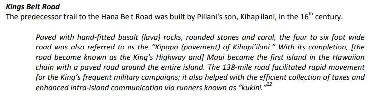
The predecessor to Kahekili Highway is the King's Highway.   During the 16th Century a 138-mile belt road known as the King's Highway was constructed around the island perimeter under the direction Maui King Kiha-a-Piilani.  King's Highway was the paved with hand fitted lava rocks and was the first perimeter road on any Hawaiian Island.  King's Highway was four to six feet wide and was intended to facilitate rapid foot travel around Maui. 


Kahekili Highway is named in honor of Maui ruler Kahekili I.  Kahekili was born during the 1700s and was known presiding over a period of conquest.  Kahekili would conquer the Islands of Oahu, Lanai and Kauai during his reign.  

A primitive road connecting Wailuku west to Honokahau appears on the 1906 F.S. Dodge Map of Maui.  


The Island of Maui seemingly was not part of the original World War II era Hawaii Route System.  Circa 1955 the United States Bureau of Public Roads renumbered the Hawaii Route System.  The 1955 Hawaii Route Renumbering saw most of the conventions utilized by the current Hawaii State Route System established.  Primary Hawaii Routes were given two-digit numbers whereas Secondary Hawaii Routes were given three-digit numbers.  The Hawaii Routes were assigned in sequence for what Island/County they were located on coupled with what Federal Aid Program number they were tied to.  In the case of the Island of Maui it was assigned numbers in the range of 30-40.

Hawaii Route 33 was designated as originating in Wailuku at Hawaii Route 32.  Hawaii Route 33 initially followed North Market Steet and the entirety of Kahekili Highway along the northwest coast of Maui to Hawaii Route 30 at Honokohau.  Hawaii Route 33 also had a bypass of downtown Wailuku which originated at Hawaii Route 32/Main Street.  The Hawaii Route 33 bypass route followed Mill Street and Central Street from Hawaii Route 32 to mainline Hawaii Route 33 at North Market Street. 

Hawaii Route 33 can be seen on the 1959 Gousha Highway Map of Hawaii.  

During the 1960s the Hawaii Route System was simplified, and numerous minor routes were shed from the State inventory.  According to hawaiihighways.com Hawaii Route 33 on North Market Street and Kahekili Highway to Waiehu Beach Road were redesignated as Maui County Route 330 during 1968.  The remaining portion of Kahekili Highway was redesignated as Hawaii Route 340 to Camp Maluhia and Maui County Route 340 to Honokohau Bay.  Kahekili Highway between Keawalua to Honokohau Bay was added back into the Hawaii State Highway System as an extension of Hawaii Route 30 sometime after 1981 or possibly 1994 according to hawaiihighways.com. 


Part 2; a drive on the Maui County Route 330 portion of Kahekili Highway

Kahekili Highway begins as Maui County Route 330 at the northern terminus of Maui County Route 33 at the end of Market Street in Wailuku.


Kahekili Highway follows Maui County Route 330 northward to the junction of Hawaii Route 340 and Hawaii Route 3400.  Kahekili Highway splits left from the junction onto Hawaii Route 340, Kahakuloa is signed as being 12 miles away.  


The Hawaii Route 340 and Maui County Route 340 portions of Kahekili Highway can be observed on hawaiihighways.com.  In recent years the Maui County Route 340 portion of Kahekili Highway has be repaved and is in far better condition than presented below.  


Comments

Popular posts from this blog

I-40 rockslide uncovers old debates on highway

The Asheville Citizen-Times continues to do a great job covering all the angles of the Interstate 40 Haywood County rock slide. An article in Sunday's edition provides a strong historical perspective on how the Pigeon River routing of Interstate 40 came about. And perhaps most strikingly, in an article that ran just prior to the highway's opening in the fall of 1968, how engineers from both Tennessee and North Carolina warned "...that slides would probably be a major problem along the route for many years." On February 12, 1969, not long after the Interstate opened, the first rock slide that would close I-40 occurred. Like many other Interstates within North Carolina, Interstate 40 through the mountains has a history prior to formation of the Interstate Highway System and was also a heated political battle between local communities. The discussion for a road that would eventually become Interstate 40 dates back to the 1940's as the idea for interregional high

Mines Road

Mines Road is an approximately twenty-eight-mile highway located in the rural parts of the Diablo Range east of the San Francisco Bay Area.  Mines Road begins in San Antonio Valley in Santa Clara County and terminates at Tesla Road near Livermore of Alameda County.  The highway essentially is a modern overlay of the 1840s Mexican haul trail up Arroyo Mocho known as La Vereda del Monte.  The modern corridor of Mines Road took shape in the early twentieth century following development of San Antonio Valley amid a magnesite mining boom.  Part 1; the history of Mines Road Modern Mines Road partially overlays the historic corridor used by La Vereda del Monte (Mountain Trail).  La Vereda del Monte was part of a remote overland route through the Diablo Range primarily used to drive cattle from Alta California to Sonora.  The trail was most heavily used during the latter days of Alta California during the 1840s. La Vereda del Monte originated at Point of Timber between modern day Byron and Bre

Former California State Route 41 past Bates Station

When California State Route 41 was commissioned during August 1934 it was aligned along the then existing Fresno-Yosemite Road north of the San Joaquin River.  Within the Sierra Nevada foothills of Madera County, the original highway alignment ran past Bates Station via what is now Madera County Road 209, part of eastern Road 406 and Road 207.   Bates Station was a stage station plotted during the early 1880s at what was the intersection of the Coarsegold Road and Stockton-Los Angeles Road.   The modern alignment bypassing Bates Station to the east would be reopened to traffic during late 1939.   Part 1; the history of California State Route 41 past Bates Station Bates Station was featured as one of the many 1875-1899 Madera County era towns in the May 21, 1968, Madera Tribune .  Post Office Service at Bates Station is noted to have been established on November 23, 1883 and ran continuously until October 31, 1903.  The postal name was sourced from Bates Station owner/operator George Ba