
The establishment of the numbering conventions of California's chargeable Interstates
The Interstate Highway System was not created in a vacuum by way of the passage of the 1956 Federal Highway Aid Act. The beginning of the Interstate Highway System can be found in the Federal-Aid Highway Act of 1944. The Federal-Aid Highway Act of 1944 was signed into law by President Franklin D. Roosevelt under the following wording:
"There shall be designated within the continental United States a National System of Interstate Highways not exceeding forty thousand miles in total extent so located as to connect by routes, as direct as practicable, the principal metropolitan areas, cities, and industrial centers, to serve the national defense, and to connect at suitable border points with the routes of continental importance in the Dominion of Canada and Republic of Mexico. The routes of the National System of Interstate Highways shall be selected by joint action of the State Highway departments of each State and the adjoining States, as provided by the Federal Highway Act of November 9, 1921, for the selection of the Federal-Aid system. All highways or routes included in the National System of Interstate Highways as finally approved, if not already included in the Federal-aid highway, shall be added to said system without regard to any mileage limitation."
The American Association of State Highway Officials (AASHO) committee on Planning and Design Policies started to develop standards for the location and design of the Interstate Highways. The first Interstate corridors were announced by the Public Roads Administration on August 2, 1947. These early Interstate corridor selections at the time did not have route number designations and comprised 37,681 miles of the Nation's principal highways. 2,882 miles of urban throughfares were included in the initial Interstate corridor selections.
.jpg)
Within California the initially selected Interstates largely followed the established corridors of several major US Routes:
- US Route 99 from the Oregon State line south to Los Angeles.
- US Route 40 from the Nevada State Line to west to San Francisco.
- A north/south corridor following Legislative Route Number 90 between Vacaville and Dunnigan.
- US Route 50 from Tracy west over Altamont Pass to Oakland.
- US Routes 91, 66 and 395 from the Nevada State Line to San Bernardino.
- US Route 66 from the Arizona State Line west to Barstow.
- US Route 70 along portions of US Routes 60 and US Route 99 from the Arizona State Line to Los Angeles.
- US Route 101 from Los Angeles to the Mexican Border.
- US Route 80 from the Arizona State Line west to San Diego.
Construction of several designated Interstate corridors would begin during 1947 without a vehicle to provide contributing Federal Funding. This would ultimately change with the passage of the Federal Highway Aid Act of 1956. The Federal Highway Aid Act of 1956 was signed into law by President Eisenhower on June 29 of said year. The Federal Highway Aid Act of 1956 provided a way for appropriations to be made towards construction of the Interstate Highway System via the Highway Trust Fund. Construction of Chargeable Interstates would be eligible for a 90% matching funding contribution.
The Federal Highway Aid Act of 1956 would establish the uniform standards of the Interstate Highway System. An amended map of the 1947 Interstate System with the basic beginnings of the numbering conventions set by AASHO was published on August 14, 1957.

The August 1957 Interstate Highway System map established numerous numbering conventions:
- North/south route numbers would begin in the west and ascend eastwards as a mirror to the US Route System. North/south Interstates were designated with odd numbers.
- East/west route numbers would begin in the south and ascend to the north as a mirror to the US Route System. East/west Interstates were designated with even numbers.
- Major north/south Interstates would end in "5" whereas major east/west routes would end in "0."
- Certain numbers like 50 and 60 were not used to avoid number duplication with US Route corridors.
Within California the initially selected chargeable Interstate corridors became:
- Interstate 5 and Interstate 5E along US Route 99 from the Oregon State line south to Los Angeles and US Route 101 south to the Mexican border.
- Interstate 80 along US Route 40 from the Nevada State Line to west to San Francisco.
- Interstate 5W along the north/south corridor following Legislative Route Number 90 between Vacaville- Dunnigan and US Route 50 between Oakland-Tracy.
- Interstate 15 along US Routes 91, 66 and 395 from the Nevada State Line to San Bernardino.
- Interstate 40 along US Route 66 from the Arizona State Line west to Barstow.
- Interstate 10 along US Route 70 along portions of US Routes 60 and US Route 99 from the Arizona State Line to Los Angeles.
- Interstate 8 along US Route 80 from the Arizona State Line west to San Diego.
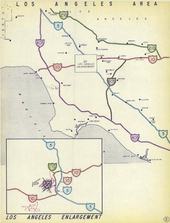
The major chargeable Interstate corridors can be seen more clearly on a zoomed version of the August 1957 Interstate Highway System map.

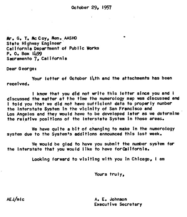
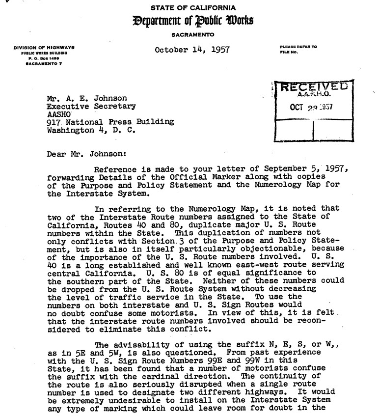
A series of October 1957 communications between the AASHO Executive Secretary and California State Highway Engineer reveal the entirety of California's initial run of chargeable Interstates. The major Interstate corridors described above are shown to have had route numbers been approved by the Commissioner of Public Roads during May 1957.
The California State Highway Engineer asked for numerous numbering changes and additions:
- A change of Interstate 5W to Interstate 3 or 7.
- A change of Interstate 5E to Interstate 5 (notably Interstate 5 south of Tracy is shown to have been realigned on the planned West Side Freeway to Wheeler Ridge).
- A change of number Interstates 80 and 40 due to duplication with existing US Routes.
- A number assignment for corridor A (future Interstate 280).
- A number assignment for corridor B (future Interstate 680).
- A number assignment for corridor C (future Interstate 405).
- A number assignment for corridor D (future Interstate 605).
- A number assignment for corridor E (future Interstate 210).
- A request not to assign a number to corridor F (the future Embarcadero Freeway and unbuilt Golden Gate Freeway).
- A request not to assign a number to corridor G (future Interstate 205).
- A request not to assign a number to corridor H (the future original iterations of Interstates 105 and 110 in downtown Los Angeles).


On November 8, 1957, the California State Highway Engineer submitted maps which contained massive changes to the planned numbers for the chargeable Interstates in California. Many of the suggested changes to the Interstate numbers pertained to avoiding duplication with the existing US Routes in California:
- Interstate 3 is shown to be proposed for what would ultimately become Interstate 280.
- Interstate 5 is shown to be proposed for what would ultimately become Interstate 680.
- Interstate 7 is shown to be proposed for established Interstate 5W between Vacaville-Dunnigan.
- Interstate 9 is shown to be proposed for what would ultimately become Interstate 405.
- Interstate 11 is shown to be proposed for established Interstate 5 and Interstate 5E.
- Interstate 12 is shown to be proposed for what would ultimately become Interstate 210.
- Interstate 13 is shown to be proposed for what would ultimately become Interstate 605.
- Interstate 30 is shown to be proposed for established Interstate 40.
- Interstate 72 is shown to be proposed for established Interstate 5W in the Oakland-Tracy corridor.
- Interstate 76 is shown to be proposed for established Interstate 80.
- What would become Interstate 205 is shown to still not have a proposed number.


A December 5, 1957, letter from the California State Highway Engineer to the AASHO Executive Secretary noted Arizona requested swapping the locations of Interstate 8 and 10. The California State Highway Engineer requested Interstate 12 be applied over established Intestate 10 and the latter number recycled over what was established Interstate 8. The same letter also requested Interstate 14 be applied to the future corridor of Interstate 210.


A February 10, 1958, letter from the AASHO Executive Secretary to the California State Highway Engineer rejected the Interstate numbering schemes submitted during November and December 1957. The rejections are noted to have been due to the use of several low route numbers and not following the core conventions of Interstate route numberings.

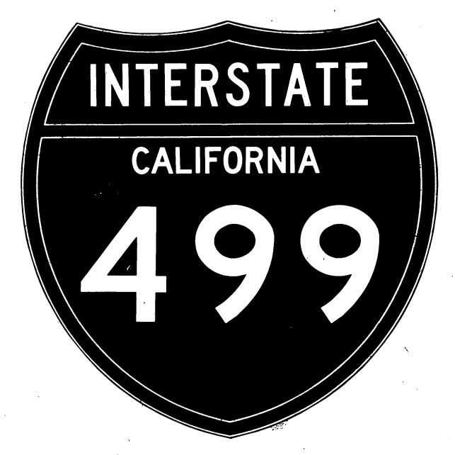
A letter dated April 1, 1958, from the California State Highway Engineer to the AASHO Executive Secretary contained new proposal for short three-digit Interstates along with two three-digit Interstate shield designs. The three-digit Interstate shield designs contained one variation with the State name and another lacking it. The proposed Interstate numbers in California changed drastically from the December 1957 plan:
- Interstate 3 was proposed for what would ultimately become Interstate 405.
- Interstate 5 was reverted back to it's established corridor.
- Interstate 8 was reverted back to it's established corridor.
- Interstate 10 was reverted back to it's established corridor.
- Interstate 40 was reverted back to it's established corridor.
- Interstate 72 was proposed for established Interstate 5W in the Oakland-Tracy corridor.
- Interstate 80 was reverted back to it's established corridor.
- Interstate 102 was proposed for what would ultimately become Interstate 210.
- Interstate 105 was proposed for what would ultimately become Interstate 605.
- Interstate 106 was proposed for what would become the original Interstate 105 and 110 in downtown Los Angeles.
- Interstate 109 was proposed for what would become Interstate 280.
- Interstate 110 was proposed for the corridor of the Golden Gate Freeway and Embarcadero Freeway.
- Interstate 112 was proposed for what would ultimately become Interstate 205.
- Interstate 113 was proposed for what would ultimately become Interstate 680.
- Interstate 115 was proposed for established Interstate 5W in the Vacaville-Dunnigan corridor.


A lettered dated August 7, 1958, from the California State Highway Engineer to the AASHO Executive Secretary contained a new draft for the Interstate numberings in California subsequent to the urban route numbering conventions being established during July 1958. The August 1958 proposal was close to the finalized numbering conventions in California but had some differences in the San Francisco Bay Area:
- Interstate 180 was proposed for what would ultimately become Interstate 280.
- Interstate 380 was proposed for the corridor of the planned Golden Gate Freeway and Embarcadero Freeway.
- Interstate 580 was proposed for what would ultimately become Interstate 680.


A letter dated November 10, 1958, would make the final alterations to initial run of chargeable Interstate Highways numbers in California. The same letter acknowledged the existence of Interstate 805 in San Diego and Interstate 880 in Sacramento. All of the final changes to the chargeable Interstate numbers were centered to the San Francisco Bay Area:
- Interstate 180 was reassigned as Interstate 280.
- Interstate 380 was reassigned as Interstate 480.
- Interstate 580 was reassigned as Interstate 680.


Comments