
Hawaii Route 92

Hawaii Route 92 is a 9.3 mile State Highway located on the Island of O'ahu.  Hawaii Route 92 connects Joint Base Pearl Harbor-Hickam east through downtown Honolulu via Nimitz Highway to Ala Moana Boulevard in Waikiki.  Hawaii Route 92 is notable due to much of the highway being located underneath the Queen Liliuokalani Freeway portion of Interstate H-1.  The Ala Moana Boulevard segment of Hawaii Route 92 was built largely over right of way which was originally set aside for proposed Interstate H-4.  

This page is part of the Gribblenation O'ahu Highways page.  All Gribblenation and Roadwaywiz media related to the highway system of O'ahu can be found at the link below:

https://www.gribblenation.org/p/gribblenation-oahu-highways-page.html


Part 1; the history of Hawaii Route 92

Prior to the Statehood the first signed highways within Hawaii Territory came into existence during World War II.   During World War II the territory of Hawaii saw an influx of military activity following the attack on Pearl Harbor on December 7th, 1941.  Numerous Military Routes and early Hawaii Routes were signed through the Hawaiian Territory to aid military personnel in navigating the islands.  Military Highways were assigned US Route style shields whereas lesser highways were assigned an early variation of what is now the Hawaii Route Spade.  

A 1946 Army Map of the Island of O'ahu shows modern Nimitz Highway as part of Hawaii Route 110 and Military Route 1 from Hickam Army Airfield to Honolulu.  A full version of the 1946 Army Map of O'ahu can be seen on hawaiihighways.com here


Circa 1955 following the conclusion of World War II the United States Bureau of Public Roads renumbered the Hawaii Route System.  The 1955 Hawaii Route Renumbering saw most of the conventions utilized by the current Hawaii State Route System established.  Primary Hawaii Routes were given two digit numbers whereas Secondary Hawaii Routes were given three digit numbers.  The Hawaii Routes were assigned in sequence for what Island/County they were located on coupled with what Federal Aid Program number they were tied to.  In the case of O'ahu the Island was assigned numbers in the range of 60-99.  In the case of Nimitz Highway it was assigned as Hawaii Route 92.

Hawaii Route 92 on Nimitz Highway can be seen constructed to Hawaii Route 61 at Nuuanu Boulevard in downtown Honolulu on the 1959 Gousha Map of Hawaii.  Ala Moana Boulevard is shown with no direct connection to Nimitz Highway.  


Notably the 1959 Gousha Map of Hawaii shows Hawaii Route 92/Nimitz Highway is being aligned alongside Hawaii Route 90/Kamehameha Highway from the outskirts of Hickam Air Force Base east to downtown Honolulu.  Hawaii Route 90 split from Hawaii Route 92 onto Dillingham Boulevard.  


Nimitz Highway is named in honor of U.S. Navy Fleet Admiral Chester W. Nimitz.  Chester W. Nimitz is well known for the role he played as Commander in Chief of the Pacific Fleet during World War II.  


Below Nimitz Highway (on the left as the two-lane highway) and Kamehameha Highway can be seen running alongside each other west of downtown Honolulu in a Hawaii Department of Transportation photo from 1951 (courtesy hawaiihighways.com).


According hawaiihighways.com what became Nimitz Highway had been planned as part of the cross-town Makai Arterial which would connect Honolulu to Hickam Army Airfield.  The Makai Arterial was dropped during 1948 and the Mauka Arterial (future Intestate H-1) through Honolulu began to be developed instead.  

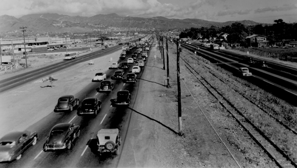
On August 21st, 1959 Hawaii became the 50th State which saw it's profile rise significantly.  The Interstate System in Hawaii was authorized as part of the 1960 Statehood Act.  The 1960 Statehood Act authorized Interstates H-1, H-2 and H-3 on the Island of O'ahu.  Hawaii Route 92 and Hawaii Route 90 from the outskirts of Hickam Airforce Base east to downtown Honolulu was selected to become part of the Queen Liliuokalani Freeway segment of Interstate H-1.  Ultimately the corridor of Hawaii Route 90 would be deleted which left Hawaii Route 92/Nimitz Highway planned as being part of a surface highway underneath Interstate H-1/Queen Liliuokalani Freeway.

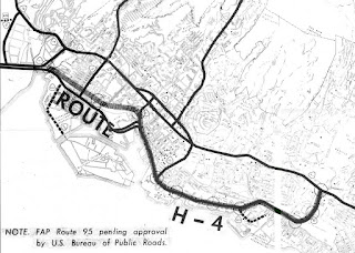
On August 24th, 1968 the Federal-Aid Highway Act of 1968 was signed into law by President Lyndon Johnson.  The Federal-Aid Highway Act of 1968 added an additional 1,500 miles to the Interstate Highway System which was to be funded through 1972.  The Federal-Aid Highway Act of 1968 was the impetus for numerous Interstate proposals which would include the concept of Interstate H-4.  Interstate H-4 was presented as a proposed highway by way of a October 1968 Hawaii of Transportation Document titled; Proposed Route H-4.

Proposed Route H-4 Section II describes proposed alignment of Interstate H-4.  Interstate H-4 is stated to have a planned length of 6.5 miles originating from the planned Keehi Interchange west of downtown Honolulu.  Interstate H-4 is described as being aligned between Nimitz Highway and Dillingham Boulevard eastward towards Ala Moana Boulevard.  Interstate H-4 is described as being planned to follow Ala Moana Boulevard eastward to Waikiki at the Ala Wai Canal.  Interstate H-4 is described as being planned to skirt Waikiki eastward via the Ala Wai Canal and looping back to Interstate H-1 via Manoa-Palolo Drainage Canal at the Kapiolani Interchange.  


An attached map shows the proposed alignment of Interstate H-4.  Interstate H-4 is shown to be categorized under Federal Aid Primary 92 which functionally made it an extension of Hawaii Route 92.  The proposed alignment of Interstate H-4 is shown to follow what is now Hawaii Route 92 from the eastern end of Nimitz Highway via an extended Ala Moana Boulevard to Ala Wai Canal.  A state highway conversion of Ala Moana Boulevard in Waikiki is shown as being planned as Hawaii Route 920.  Ala Moana Boulevard in Waikiki would ultimately become the eastern terminus of Hawaii Route 92 at Kalakaua Boulevard.  Notably the planned interchange structures on proposed Interstate H-4 are shown as circles.  


An attached Hawaii Department of Transportation Memorandum For Record cites the Interstate H-4 proposal being presented on October 18th, 1968.  The corridor of Interstate H-4 is ultimately cited as not being recommended.  A cost estimate of $600,000,000 million dollars to construct Interstate H-4 is cited as being cost prohibitive.  $400,000,000 dollars of the estimate is cited being earmarked for a largely underground tube alignment of Interstate H-4 (a tube alignment is not described in Proposed Route H-4).  The corridor of the Makai Arterial is cited as having merit if pursued via an alternative which ultimately led to Hawaii Route 92 being extended to Waikiki via Ala Moana Boulevard.  


Interstate H-1 on the Queen Liliuokalani Freeway from Exit 5 (HI 76/HI 750) to its western terminus opened during 1967.  The Queen Liliuokalani segment of Interstate H-1 was completed east to Hawaii Route 78 (future Interstate H-201) by 1971.  The completion of the Queen Liliuokalani Freeway saw the advent of the modern alignment of the Hawaii Route 92/Nimitz Highway underneath much of Interstate H-1.  The Queen Liliuokalani segment of Interstate H-1 was gradually extended east of Hawaii Route 78 to the Lunalilo Freeway segment of Interstate H-1 culminating in the completion of the Intestate during May of 1986. 


Part 2; Roadwaywiz on Hawaii Route 92

During May of 2019 Dan Murphy featured Hawaii Route 92 on the Roadwaywiz Youtube channel.  Part 1 below features Hawaii Route 92 beginning at Kalakaua Avenue in Waikiki westward on Ala Moana Boulevard towards Nimitz Highway.  Notably reassurance signage on much of Hawaii Route 92/Ala Moana Boulevard notes the highway directly accesses Daniel K. Inouye International Airport.  


Part 2 features Hawaii Route 92 transitioning onto Nimitz Highway in downtown Honolulu and following westward underneath Interstate H-1/Queen Liliuokalani Freeway.

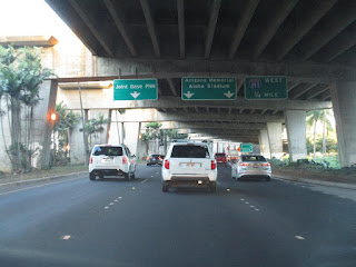
Part 3 features Hawaii Route 92 on Nimitz Highway underneath Interstate H-1/Queen Liliuokalani Freeway westward past Daniel K. Inouye International Airport towards the Hawaii Route 99/Kamehameha Highway junction towards Joint Base Pearl Harbor-Hickam.


Below numerous photos from westbound Hawaii Route 92 can be observed.


Part 3; a drive on eastbound Hawaii Route 92

Below Hawaii Route 92 begins on Nimitz Highway departing Joint Base Hickam-Pearl Harbor and splits underneath the Queen Liliuokalani Freeway segment of Interstate H-1 at the Interstate H-1/Hawaii Route 99 junction.  


Hawaii Route 92 eastbound follows Nimitz Highway underneath Interstate H-1 past Daniel K. Inouye International Airport.  


Hawaii Route 92 follows Nimitz Highway eastward and splits from underneath the Queen Liliuokalani freeway segment of Interstate H-1 towards downtown Honolulu.  


Hawaii Route 92 follows Nimitz Highway eastbound and transitions onto Ala Moana Boulevard.


Hawaii Route 92 follows Ala Moana Boulevard eastward and crosses Ala Wai Canal into Waikiki.  Upon entering Waikiki Hawaii Route 92 follows Ala Moana Boulevard to a terminus at Kalakaua Avenue near Fort Derussy Park.  


The Fort DeRussy Military Reservation in Waikiki is under the jurisdiction of the U.S. Army but functions more as a park during modern times.  Fort DeRussy was originally constructed during 1911 along with Battery Randolph.  Battery Randolph now houses the U.S. Army Museum of Hawaii.


From Fort DeRussy Beach one can see how much Diamond Head Crater towers of Waikiki.  


Comments

Popular posts from this blog

Memphis & Arkansas Bridge (Memphis, TN)

  Like the expansion of the railroads the previous century, the modernization of the country’s highway infrastructure in the early and mid 20th Century required the construction of new landmark bridges along the lower Mississippi River (and nation-wide for that matter) that would facilitate the expected growth in overall traffic demand in ensuing decades. While this new movement had been anticipated to some extent in the Memphis area with the design of the Harahan Bridge, neither it nor its neighbor the older Frisco Bridge were capable of accommodating the sharp rise in the popularity and demand of the automobile as a mode of cross-river transportation during the Great Depression. As was the case 30 years prior, the solution in the 1940s was to construct a new bridge in the same general location as its predecessors, only this time the bridge would be the first built exclusively for vehicle traffic. This bridge, the Memphis & Arkansas Bridge, was completed in 1949 and was the third

Old River Lock & Control Structure (Lettsworth, LA)

  The Old River Control Structure (ORCS) and its connecting satellite facilities combine to form one of the most impressive flood control complexes in North America. Located along the west bank of the Mississippi River near the confluence with the Red River and Atchafalaya River nearby, this structure system was fundamentally made possible by the Flood Control Act of 1928 that was passed by the United States Congress in the aftermath of the Great Mississippi River Flood of 1927 however a second, less obvious motivation influenced the construction here. The Mississippi River’s channel has gradually elongated and meandered in the area over the centuries, creating new oxbows and sandbars that made navigation of the river challenging and time-consuming through the steamboat era of the 1800s. This treacherous area of the river known as “Turnbull’s Bend” was where the mouth of the Red River was located that the upriver end of the bend and the Atchafalaya River, then effectively an outflow

California State Route 203 the proposed Minaret Summit Highway

California State Route 203 is an approximately nine-mile State Highway located near Mammoth Lakes in the Sierra Nevada Mountains of Mono County.  California State Route 203 as presently configured begins at US Route 395, passes through Mammoth Lakes and terminates at the Madera County line at Minaret Summit.  What is now California State Route 203 was added to the State Highway System in 1933 as Legislative Route Number 112.  The original Mammoth Lakes State Highway ended at Lake Mary near the site of Old Mammoth and was renumbered to California State Route 203 in 1964.  The modern alignment of the highway to Minaret Summit was adopted during 1967.   The corridor of Minaret Summit and Mammoth Pass have been subject to numerous proposed Trans-Sierra Highways.  The first corridor was proposed over Mammoth Pass following a Southern Pacific Railroad survey in 1901.  In 1931 a corridor between the Minarets Wilderness and High Sierra Peaks Wilderness was reserved by the Forest Service for po