
US Route 101 in Benbow, Garberville and Redway

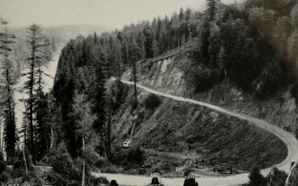
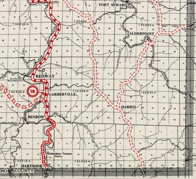
The communities of Benbow, Garberville and Redway can all be found along US Route 101 within southern Humboldt County.  The former surface alignment of US Route 101 in Garberville and Redway once crossed the Garberville Bluffs along what is now Redwood Drive via a corridor constructed as part of the Redwood Highway during the 1910s.  US Route 101 through Benbow, Garberville and Redway was modernized by 1935.  US Route 101 would eventually be upgraded to freeway standards in Benbow, Garberville and Redway by extension of the Redwood Freeway during 1966-68.  As the cover photo the original grade of US Route 101 and the Redwood Highway can be seen at the Garberville Bluffs during 1934.  US Route 101 can be seen in the communities of Benbow, Garberville and Redway on the 1935 Division of Highways Map of Humboldt County.  


The history of US Route 101 in Benbow, Garberville and Redway

Benbow, Garberville and Redway lie on the banks of the South Fork Eel River of southern Humboldt County.  During the American period of the State of California what is now Garberville was settled during 1853 by explorer Antone Garcia.  Garberville first received Post Office Service during 1874.  Garberville was named after the first community Postmaster Jacob C. Garber.  Garberville would never incorporate as a city.  

Garberville can be seen along the road between Shelter Cove and the Rattlesnake Grade on the 1882 Bancroft's Map of California.  


During 1922 the children of Arthur Benbow purchased 1,290 acres of land south of Garberville for ranching purposes.  Ranching proved to be inefficient, and the family decided to construct an Inn on their property.  The Benbow Inn would open on July 17, 1926, along the banks of the South Fork Eel River.  Benbow would receive Post Office Service during December 1929.  The Benbow Post Office would merge with the Garberville Post Office during January 1953.  

Redway was founded during 1923 by Oscar and Charles Burris.  The Burris brothers originally plotted Redway as a resort style golf course, the naming convention which remains apparent in the street grid of the community.  During the 1930s the Burris brothers subdivided their resort holdings which grew into the modern community of Redway.  Like nearby Garberville, the community of Redway would never incorporate as a city.  

The history of what would become the Redwood Highway (later US Route 101) begins with the approval of the 1909 First State Highway Bond Act.  The First State Highway Bond Act was approved by voters during 1910 and was the genesis point of some of the most notable highways in California.  Legislative Route Number 1 (LRN 1) in it's original form was a new State Highway which was designated between San Francisco north to Crescent City.  The route of LRN 1 would be extended to the Oregon State Line during the 1919 Third State Highway Bond Act.  The planned routing of LRN 1 can be seen between Garberville of Humboldt County and Cummings of Mendocino County on the 1917 California State Automobile Association Map.

Prior to the construction of LRN 1 wagon borne traffic heading north from Cummings to Humboldt County had to ascend the treacherous Rattlesnake Grade (also known as the Bell Springs Grade).  The Rattlesnake Grade is described in the July 1916 California Highway Bulletin as being only passable during the summer months.  The initial north climb on the Rattlesnake Grade ascended grades as high as 20% the from Cummings to the 4,100-foot-high Bell Springs Mountain.  The descent from Bell Mountain to Dyerville (now on California State Route 254/Avenue of the Giants) is described as having grades as steep as 30% amid an elevation drop of just over 3,900 feet.  The construction of LRN 1 (then known as the Mendocino State Highway) sought to follow the Eel River watershed to bypass the Rattlesnake Grade.  Note: The Rattlesnake Grade can be seen on the 1917 California State Automobile Association Map between Cummings and Dyerville.


Much of the Rattlesnake Grade still exists as modern Bell Springs Road.   The Rattlesnake Grade can be seen in detail between Garberville-Cummings on the 1935 Division of Highways Maps of Humboldt County and Mendocino County


The completed Redwood Highway/LRN 1 between Cummings and Garberville can be seen on the 1920 Clason Highway Map of California.  

The March 1926 California Highways & Public Works featured emergency slide repairs along the Redwood Highway/LRN 1 near Garberville. 

During November 1926 the US Route System was created by the American Association of State Highway Officials.  US Route 101 from San Francisco north to Crescent City was aligned over the Redwood Highway.  Both US 101 and the Redwood Highway between Garberville and Cummings can be seen on the 1927 Rand McNally Highway Map of California.  Within Redway and Garberville US Route 101 was aligned on Redwood Drive. 

The December 1929 California Highways & Public Works announced bids were received by the Division of Highways to widen US Route 101/LRN 1 from Garberville north to the outskirts of Redway at Bluff Creek to 28 feet.  

The January/February 1933 California Highways & Public Works announced the widening of US Route 101/LRN 1 from Benbow 7 miles north through Garberville and Redway as being budgeted for the 1933-35 Fiscal Years.  The segment of US Route 101/LRN 1 through Garberville-Redway is described as being one of the most dangerous, steep and narrow portions of the Redwood Highway.  


The June 1934 California Highways & Public Works previews the in-progress realignment/straightening of US Route 101/LRN 1 through Benbow, Garberville and Redway.  The article stub notes Redwood Highway/LRN 1 between Benbow and Garberville was completed by 1914 whereas the segment north to Bluff Creek was completed by 1917.  The incomplete realignment of US Route 101/LRN 1 is noted to reduce the number of curves in the Benbow/Garberville/Redway corridor from 130 to 34 over a 0.46-mile shorter routing.  The existing alignment of US Route 101/LRN 1 in the Benbow/Garberville/Redway corridor is noted to pass what was then known as the Redway Bluffs.  


US Route 101 can be seen passing through Benbow, Garberville and Redway on the 1935 Division of Highways Map of Humboldt County.  


The June 1935 California Highways & Public Works featured the completed realignment/straightening of US Route 101/LRN 1 in the Benbow/Garberville/Redway corridor.  The new alignment of US Route 101/LRN 1 with 96 less curves is cited to have been dedicated on a June 9, 1935, in a ceremony presided over by Governor Frank F. Merriam.  


The May/June 1956 California Highways & Public Works announced the completion of a 50-mile-long corridor study to upgrade US Route 101/LRN 1 in southern Humboldt County to freeway standards.  The corridor study is stated to have begun on August 20, 1953, spanning from the Mendocino County line north to Jordan Creek.  The location of the new Redwood Freeway corridor of US Route 101 was approved by the State Highway Engineer on January 25, 1956.  A public hearing on the new US Route 101 Redwood Freeway corridor was held in Garberville on February 8, 1956.  Article photos show a benched portion of US Route 101 on the Garberville Bluffs and the existing highway along Redwood Drive in Garberville.  


The March/April 1957 California Highways & Public Works discusses the modernization of US Route 101/LRN 1 in Humboldt County.  The first segment of the Redwood Freeway slated to be constructed was a segment from Englewood south to the vicinity of Dyerville.  Population increases in Humboldt County, traffic, and even rainfall were all cited as reasons for the expansion of US Route 101/LRN 1 via the Redwood Freeway project.


The initial construction of the Redwood Freeway in the vicinity of Weott is discussed in the September/October 1957 California Highways & Public Works.  


The November/December 1959 California Highways & Public Works features a report from Division Highways District I on the expansion of US Route 101/LRN 1.  The "Redwood Parks Freeway" is cited to recently had a second segment completed from Myers Flat 7.5 miles north to the vicinity of Dyerville.  This second segment of the Redwood Parks Freeway connected with the first completed segment which continued another 4.4 miles northward.  The recently bypassed portions of US Route 101 from Myers Flat to the vicinity of Englewood were retained under State Control as a spur of LRN 1 and would form the basis for Avenue of the Giants. 


The recently completed Redwood Parks Freeway can be seen on the 1960 Division of Highways State Map as US Route 101/LRN 1 north of Dyerville. 

The September/October 1960 California Highways & Public Works announced that 25 miles of former US Route 101/LRN 1 north from Miranda would be maintained by the State Division of Parks and Beaches as Avenue of the Giants.  Avenue of the Giants was announced on August 27, 1960, by then Governor Edmund G. Brown.  

The September/October 1963 California Highways & Public Works notes that the State had formalized it's commitment to maintaining Avenue of the Giants by giving it a specific routing definition.  

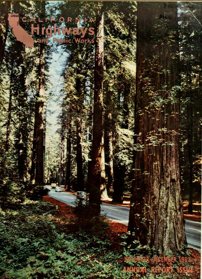
Avenue of the Giants is featured on the cover the November/December 1963 California Highways & Public Works.  


According CAhighways.org the Legislation that added Avenue of the Giants formally to the State Highway System was Chapter 890 which was duplicated by Chapter 901.  Avenue of the Giants was assigned Legislative Route Number 296 which was replaced by California State Route 254 for the 1964 Highway Renumbering.  The initial definition of California State Route 254 can be seen on the 1964 Division of Highways State Map as; "Avenue of the Giants, comprising a former portion of Redwood Highway through and connecting a number of state parks, from Route 101 near the Sylvandale interchange to Route 101 near the Redcrest interchange."  Notably US Route 101 can be seen with a Legislative Route Number of 254 from Phillipsville north to Myers Flat on the 1964 Division of Highways Map as the new alignment of US Route 101 had not been built yet.


The history of the Redwood Highway, expansion of US Route 101, and Avenue of the Giants are all discussed in the September/October 1964 California Highways & Public Works.   A photo of US Route 101 near Garberville is featured.  


The 1965 Division of Highways State Map shows US Route 101 bypassing Phillipsville and Miranda to Myers Flat.  The former segment of US 101 is shown legislatively as part of Route 254. 

The November/December 1965 California Highways & Public Works references freeway upgrades to US Route 101 at Sylvandale to 0.8 miles south of Garberville as being budgeted for the 1966-67 Fiscal Year.  


The March/April 1966 California Highways & Public Works references the new US Route 101 freeway bypassing Redway, Garberville having an anticipated opening during Fall 1967.  A northward view on the recently completed fifth unit of the Redwood Freeway corridor downstream from Garberville is featured.  


The November/December 1966 California Highways & Public Works announced an extension of the Redwood Freeway from 0.8 miles south of Garberville to 1.8 miles south of Benbow as being budgeted for the 1967-68 Fiscal Year. 


The California Highways & Public Works publication ended before the freeway bypasses of Redway, Garberville and Benbow were completed.  US Route 101 appears on a new freeway bypass of Redway, Garberville and Benbow on the 1969 Division of Highways Map.  Within Redway and Garberville the former alignment of US Route 101 on Redway Drive was left as a local frontage.  The existing grade of US Route 101 in Benbow was widened to freeway standards.  


Comments

Popular posts from this blog

Former US Route 50 and the Pioneer Route Lincoln Highway on Johnson's Pass Road

Johnson's Pass Road is one of the oldest highway corridors in California.  Johnson's Pass was part of the Lake Tahoe Wagon Road as it was completed during 1856 over the Sierra Nevada.  The pass would later be incorporated into the Pioneer Branch of the Lincoln Highway in 1913 and US Route 50 in 1926.  Johnson's Pass Road would be bypassed by a new alignment of US Route 50 over Echo Summit in 1938.  A replacement of the Meyers Grade east of Johnson's Pass would be opened to traffic in 1947.   Johnson's Pass Road remains accessible to traffic and is still signed by the Lincoln Highway Association.  Pictured as the blog cover is the view from the top of Johnson's Pass Road overlooking modern US Route 50 and Lake Tahoe.   Part 1; the history of Johnson's Pass Much of the history of what become the Lake Tahoe Wagon Road is discussed in the  September 1950 California Highways & Public Works  during its Centennial Edition.  The or...

Former US Route 50 and the South Lincoln Highway from Folsom east to Placerville

The corridor of Folsom of Sacramento County east to Placerville of El Dorado County has been a long established corridor of overland travel dating back to the California Gold Rush.  The Folsom-Placerville corridor was once part of the path of the Lake Tahoe Wagon Road which became the first California State Highway and later the South Lincoln Highway.  In time the South Lincoln Highway's surface alignment was inherited by US Route 50.  The Folsom-Placerville corridor also includes the communities of; Clarksville, Shingle Springs and El Dorado. Part 1; the history of the Lake Tahoe Wagon Road, South Lincoln Highway and US Route 50 through Folsom-Placerville Folsom is located on the American River/Lake Natoma of eastern Sacramento County.  That lands now occupied by the City of Folsom were part of Rancho Rio de los Americanos prior to the finding of gold at Sutter's Mill during 1848.  During the California Gold Rush the lands of Rancho Rio de los Americanos were p...

Old NC 10 - The Central Highway: Old Fort to Black Mountain through the Royal Gorge

A unique way of tracing the remnants of the Central Highway is through the mountainous terrain of Eastern Buncombe and Western McDowell Counties.  From the east on US 70, you reach the base of Blue Ridge Mountains at the town of Old Fort.  Old Fort is a tiny rail town that the old Central Highway and now US 70 goes through.  The Central Highway can be followed via a right onto Mill Creek Road from US 70.  Follow the highway as it takes you closer to the mountains.  When Mill Creek Road bears right to head towards Andrews Geyser stay straight until the road ends at a gate.  The nearby Piney Grove Church can be used for parking.  At this point, the old Central Highway began a 3.5 mile climb of the mountain to Swannanoa Gap.  NC 10 and later US 70 travelers followed this road for over 30 years until a new and modern four lane US 70 was built to the south.  This same four lane road would eventually become Interstate 40.    The Centra...